 +1 credit
| Version | Summary | Created by | Modification | Content Size | Created at | Operation |
|---|---|---|---|---|---|---|
| 1 | Faezeh Pasandideh | -- | 3145 | 2022-11-30 17:14:06 | | | |
| 2 | Lindsay Dong | + 23 word(s) | 3168 | 2022-12-01 09:47:50 | | |
Video Upload Options
Unmanned aerial vehicles (UAVs), or drones, have made them able to communicate and collaborate, forming flying ad hoc networks (FANETs). FANETs are becoming popular in many application domains, including precision agriculture, goods delivery, construction, environment and climate monitoring, and military surveillance. These interesting new avenues for the use of UAVs are motivating researchers to rethink the existing research on FANETs.
1. Introduction
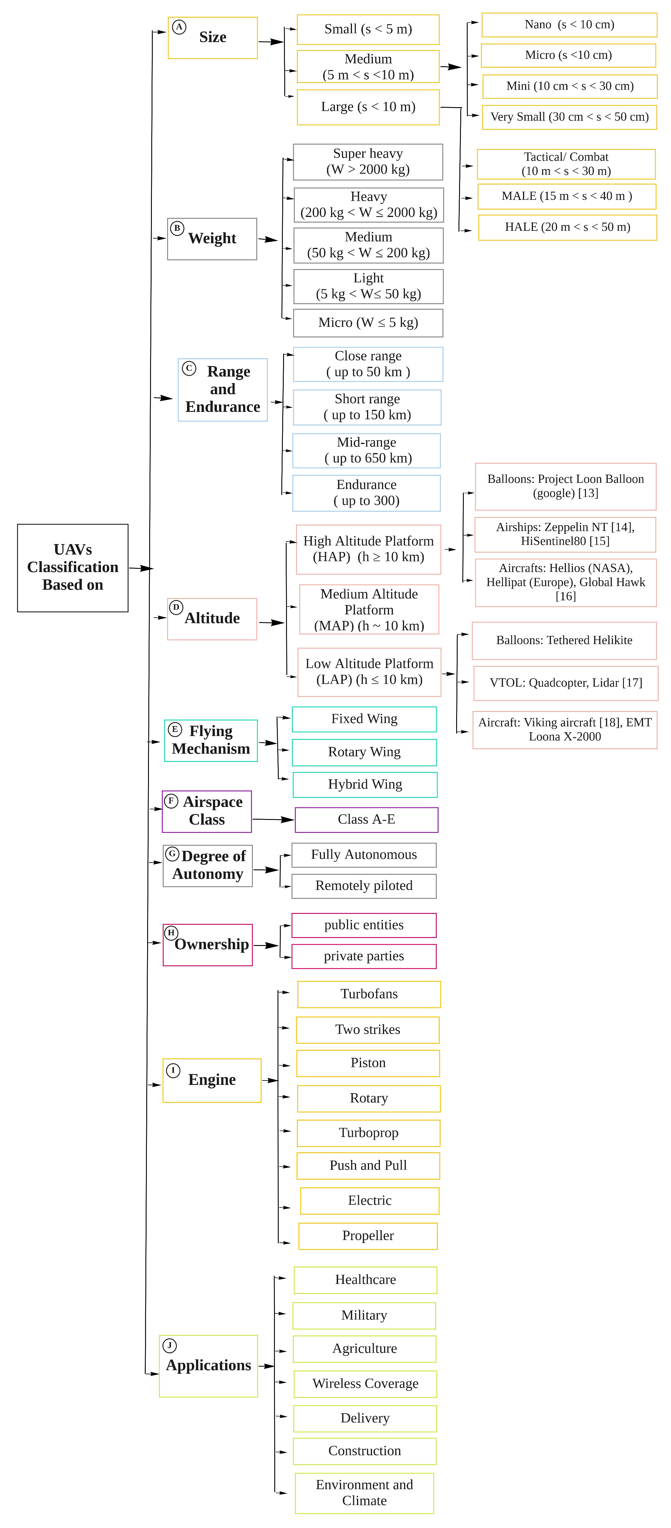
2. UAV Classification
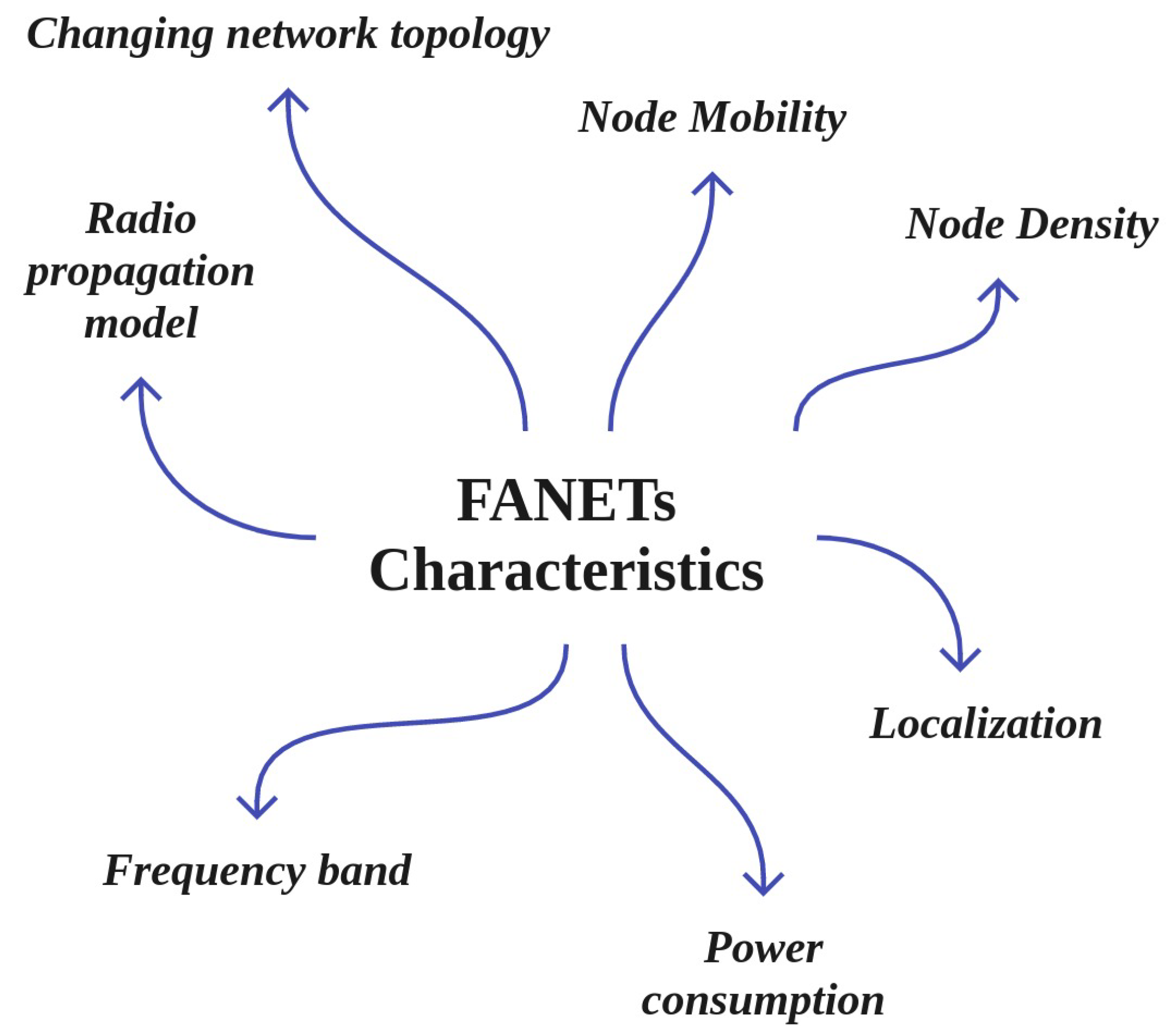
3. Main Characteristics of FANETs
4. Main Applications of FANETs
-
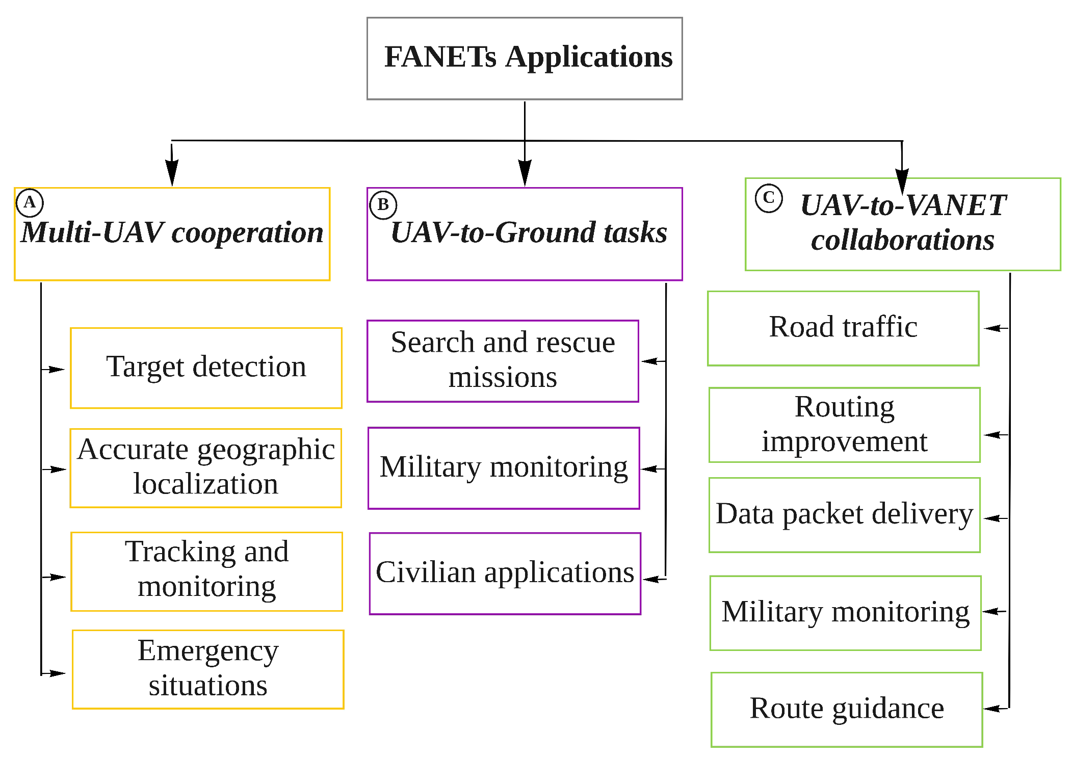
Multi-UAV cooperation: Figure 3, box A shows the following applications, which can be categorized as multi-UAV cooperation:
- –
- –
-
Tracking and monitoring in disaster situations: UAVs can help to assess the direction in which a flood is moving, then predict what buildings are exposed to damage. Similarly, they can be used for rescue operations in the aftermath of earthquakes, identifying collapsed population-dense buildings such as hospitals and schools so that these areas are given a higher priority in rescue operations [30][31].
- –
-
Emergency situations: UAVs are used in the construction industry to check safety and to monitor the progress of construction and buildings. UAVs can be used to provide temporary wireless coverage in cellular networks during emergencies when the ground base stations are out of service, as well as in many other emergency scenarios [32][33].

-
UAV-to-Ground tasks: Figure 3, box B shows the following applications for UAV-to-ground cooperation:
- –
-
Public and civilian applications: UAVs have been widely used for public and civilian domain applications, especially in the form of small quadcopters, as their cost effectiveness and flexibility provide advantages over ground-based infrastructure [34].
- –
-
Search and rescue missions: UAVs play a vital role in search and rescue missions (SAR). FANETs are considered an immense advantage in guaranteeing public safety, performing SAR missions, and managing man-made or natural disasters such as floods, earthquakes, forest fires, tsunamis, terrorist attacks, and checking the safety of critical infrastructure such as power and water utilities. It is important to provide communications coverage in such situations. In situations when public communications networks are disrupted, UAVs can provide timely disaster warnings and help to speed up rescue and recovery operations. UAVs can carry medical equipment to inaccessible regions. They can make SAR operation much faster in situations such as avalanches, wildfires, searching for missing persons, and more.
-
UAV-to-VANET collaborations between UAVs and vehicles: As shown in Figure 3, box C, the following applications involve cooperation between UAVs and vehicles:
- –
-
Roadway traffic monitoring: FANETs can be employed instead of intensive labour and complex observational infrastructure to carry out road traffic monitoring. In roadway traffic monitoring, UAVs are able to detect traffic crashes and then report these incidents easily. Using UAVs is much faster than using the incident commander’s vehicle. In addition, UAVs can be used to provide road safety by capturing real-time videos from various security scenarios and situations in road networks [35].
- –
-
Data packet delivery: Data delivery to mobile ad hoc nodes is a challenging task, as it is difficult to find a reliable forwarding path to ensure that data is delivered from one user to another. In this respect, UAVs are widely used as airborne communication relays to deliver data collected by ground devices to distant control centres. In other words, UAVs deliver packet data based on the load-carry-and-delivery (LCAD) paradigm, in which data is loaded from the source node and forwarded to the destination node utilizing multiple UAVs [36][37].
- –
5. FANET Routing Protocols
-
Position-based (Figure 4, box A): In these protocols, the geographic information of the nodes is known from GPS, and the positions of the sender and receiver are determined in advance using reactive, predictive, greedy [40], and hierarchical [41][42][43] methods, as shown in Figure 4, box A. The position-based hop by hop protocols usually dynamically select relay nodes. The packets are broadcast blindly by the node, and the selection of the relay is postponed until the neighbours of the node receive the packets. After the neighbours receive the packets, they calculate the dynamic forwarding delay (DFD) values according to their local position information in a distributed manner and then forward the packets to the destination greedily. The nodes closest to the destination then acquire the minimum DFD value and become the next forwarder [44].
-
Topology-based (Figure 4, box B): In topology-based hop by hop routing protocols, the senders forward packets through an optimal path using the network’s topology information along with link- state information such as IP address [45]. As shown in to Figure 4, box B, these can be classified as static [46], proactive [47], reactive [48], and Hybrid.
-
Delay-tolerant networks (DTNs) (Figure 4, box C): In DTNs, the mobile nodes are intermittently and unstably connected. As the mobile nodes experience high latency and low data rates, new routing protocols are needed to address the DTN characteristics [24]. The three main DTN-based routing protocols studied for FANETs are deterministic, social network, and stochastic [24], which are depicted in Figure 4, box C.
-
Heterogeneous (Figure 4, box D): FANETs interact with various ground networks, such as VANETs, MANETs, or fixed nodes, in which heterogeneous routing protocols are required for exchanging data between moving users. Routing protocols with heterogeneous techniques can support both mobile and fixed nodes in FANETs [49]. This technique can provide sub-network assistance coverage for both nodes on the ground and UAVs, network extension, and more [50]. The classification of heterogeneous routing protocols is shown in Figure 4, box D.
-
Cluster-based (Figure 4, box E): In the clustering technique, nodes with similar characteristics and features are combined to form clusters. There is a cluster head in each cluster that carries out communication processing [51]. As shown in Figure 4, box E, cluster-based routing protocols in FANETs can be classified into two main categories, namely, probabilistic and deterministic. A full classification of cluster-based routing protocols in FANETs is shown in Figure 4, box E.
6. UAV Mobility Models
7. Integration of Technologies with the UAV-Networked Systems
-
Augmented reality (AR) and Virtual Reality (VR) technologies (Figure 5, box A): VR, which is shown in Figure 5, box A, has been integrated with UAV-networked systems for greater integration of the virtual and real worlds. Such integration can create a virtual environments for multiple purposes, including marketing, agriculture, entertainment, education, and more, by taking over people’s vision and making them feel as if they are somewhere else. AR is considered a variation of VR; VR technology, there is an essential need for 3D data on a large scale. In this regard, UAVs that can freely fly in the sky are excellent tools for collecting 3D data. Several studies have investigated the use of VR technology and UAV networks [5][6][7][8][9].
-
IoT-enabled UAV communication system (Figure 5, box B): The integration of UAVs with IoT is called the Internet of Flying Things (IoFT) [10][11] or Internet of Drone Things (IoDT) [12]. IoFT or IoDT represents a new research topic related to IoT, cellular networks, cloud, fog, and edge computing, big data, intelligent computer vision, and security techniques. IoFT or IoDT can efficiently support different applications in various fields ranging from disaster management to smart industry, providing high connectivity, scalability, flexibility, and availability.
-
Integration with Cloud Computing (Figure 5, box C): As shown in Figure 5, box C, cloud computing has been integrated with FANETs; known as cloud-based UAV or flying cloud computing, this can improve and increase storage, network bandwidth, and processing. Such an integrated system includes three main layers: a UAV layer, a cloud server layer, and a ground control system (GCS)/client layer. The UAV layer collects sensor data such as pressure, temperature, etc., while flying and transmits the collected data to the cloud for storage and processing using 3G/4G/5G cellular communication devices or other technologies such as WiMAX, WiFi, etc. The communication layer is responsible for providing wireless connectivity for the UAVs and GCS any time and anywhere without any limitations on communication range. The last layer contains the cloud servers that store and process different types of data, such as geographical location parameters, environment variables, sensor data, images, etc., received from the UAVs to detect various events [10][58][59][60].
-
Flying Edge Computing (Figure 5, box D): Edge computing allows data storage and computing closer to the sources of data. Edge computing has been integrated with FANET (flying edge computing) to mitigate the hardware limitations of UAVs and improve the performance of UAV networks [13]. Flying edge computing is employed to support real-time IoT applications such as video streaming surveillance, VR and AR, and smart transportation [61]. In flying edge computing, UAVs are associated with edge IoT devices such as GBSs to offload and migrate part of the data computation to the edge layer; the other parts of computation tasks are locally managed by the UAVs [62] without the intervention of the cloud [63]. Integrating UAVs with edge computing provides low latency and response time for different IoT real-time applications. However, certain applications require storage and computing of voluminous data such as video streams. The local resources of edge IoT devices cannot efficiently support such cases. Therefore, flying fog computing can be expanded to the core network to provide low latency for storage and processing of huge amounts of UAV data [10].
-
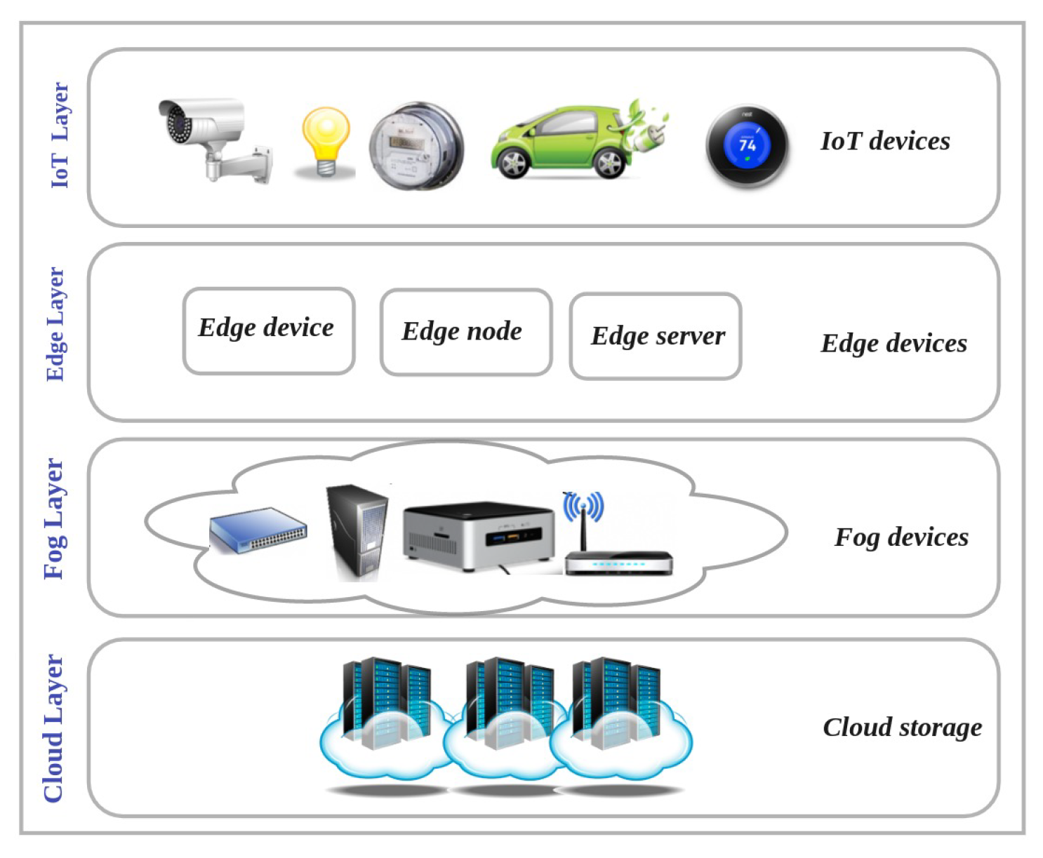
Flying Fog Computing (Figure 5, box E): Flying fog computing, which is located at the edge of the network, provides an intermediate level between the cloud and UAV layers. The fog layer communicates with the UAV layer through wireless connection and the cloud layer using the internet. The integration of fog computing and UAVs provides low latency for real-time UAV-assisted IoT applications along with high capacity in terms of computing and storage. Although the flying fog computing paradigm provides enough computing power for IoT nodes, a major issue involves the integration of the UAVs in the edge computing layer with the cloud computing layer [10][14][15]. Figure 6 shows the cloud, fog, edge, and IoT layers.
-
Integrating UAVs into cellular networks (Figure 5, box F): Agile UAVs are a special class of lightweight fixed-wing UAVs with small control surfaces [64]; they can be used as flying base stations, mobile relays, users, sensors, network controllers, and even as a scheduler in a cellular network [16], providing high reliability and low latency in communications. In UAV-based cellular networks, UAVs are mostly equipped with small BSs to provide temporary required communication links and cover the hard-to-reach regions. These flying BSs are more adaptive, flexible, and cost-effective than conventional towers or pole-mounted or rooftop BSs [17]. However, cellular networks have limitations in terms of supporting UAV communications. For example, optimally deploying UAVs is one of the most challenging issues in this context [18][19]. Therefore, new communication technologies such as 5G and 6G that support aerial and satellite communication are needed to manage UAV traffic in very dense air traffic scenarios [31][65][66][67]. There are challenges with integrating 5G and 6G with FANETs, which can suffer from issues and is a very complex task with many technical issues which need to be addressed [24].
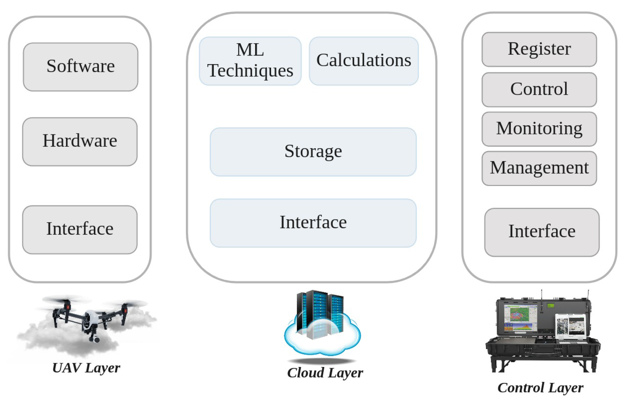
8. Main Components of Cloud-Based UAV Managing Systems (CBUMS)
-
UAV Layer: As shown in Figure 7, in the UAV layer (i.e., the physical layer), UAVs that are connected with the IoT cloud using short- and long-range wireless technologies can perform different tasks, ranging from traffic monitoring to delivery. The cloud layer sends control information and signals about the traffic situation to the UAV layer to guide responses based on the desired GBS in the control layer. In the UAV layer, multiple network components such as drone-to-target (D2T) and drone-to-drone (D2D) are attached [20][68].
-
Cloud Layer: The cloud layer, which is the heart of CBUMS, transfers the data between the UAV and control layers. As can be seen in Figure 7, the storage, computation, ML techniques, and interface are the main components of the cloud layer [20][68].Storage: The cloud layer captures streams of data about the location, environment, and UAV mission information, storing the captured data in a regular SQL database or NoSQL database based on the application’s requirements.Calculations and ML techniques: Several computation algorithms, such as map/reduce, data analytics, image processing, ML techniques (including supervised and unsupervised learning algorithms), RL and DRL-based algorithms, and FL-based techniques are executed in the cloud to improve the system performance and fix existing open issues.Interface: The interface contains web and network services that make connections between control and UAV layers. Interfaces in the cloud layer take advantage of various communication protocols, including wireless personal area networks (WPAN), wireless local area networks (WLAN), low-power wide-area networks (LPWAN), and cellular networks. In applications that require UAVs to directly communicate with the central station, a WiFi transmission system is used. However, long-term evolution (LTE) and long-range area networks (LPWAN) provide lower-latency communication systems than WIFi.
-
Control Layer: As Figure 7 shows, the control layer includes GCSs that remotely register, control, manage, and monitor UAVs from a location close to or inside the flying field. The GCS contains application software that receives collected data from UAVs and sends control signals to them. The users can monitor UAVs, set task parameters, and modify them through the data analysis implemented by the cloud based on the application software [20][68].
9. Simulation Tools
Evaluating the performance of UAV-based communication networks in the real world is a difficult task that requires a remarkable amount of time and resources. Frequent topology changes and the high degree of mobility of the UAVs in FANETs make the practical evaluation of UAV performance a challenging, costly, and time-consuming task. In addition, due to regulations around using UAVs in most countries, certain types of cyber-attack resistance evaluation tests for UAV networks are not allowed [2]. Therefore, many flexible simulation tools, frameworks, emulators, and testbeds have been developed to make it possible to create, implement, test, and evaluate schemes virtually without requiring real-world implementation. The available FANET performances analysis tools include AVENS, CUSCUS, Simbeeotic, UAVSim, UTSim, FANETSim, Netsim, OMNeT++, NS2,NS3, OPNET, ROS-NetSim, MATLAB, TOSSIM, QualNet, GloMoSim, YANS, ONE, SSFNet, FlynetSim, J-Sim, BonnMotion, GAZEBO, AirSim, RoboNetSim, Mininet-Wifi, and SUMO, each of which supports different mobility models, operating system, and programming languages [69][70][71][72].
References
- Mozaffari, M.; Saad, W.; Bennis, M.; Nam, Y.H.; Debbah, M. A Tutorial on UAVs for Wireless Networks: Applications, Challenges, and Open Problems. IEEE Commun. Surv. Tutor. 2019, 21, 2334–2360.
- Chriki, A.; Touati, H.; Snoussi, H.; Kamoun, F. FANET: Communication, mobility models and security issues. Comput. Netw. 2019, 163, 106877.
- Sahingoz, O.K. Networking Models in Flying Ad-Hoc Networks (FANETs): Concepts and Challenges. J. Intell. Robot. Syst. 2014, 74, 513–527.
- Sultan, L.; Anjum, M.; Rehman, M.; Murawwat, S.; Kosar, H. Communication Among Heterogeneous Unmanned Aerial Vehicles (UAVs): Classification, Trends, and Analysis. IEEE Access 2021, 9, 118815–118836.
- Lahmeri, M.A.; Kishk, M.A.; Alouini, M.S. Artificial Intelligence for UAV-Enabled Wireless Networks: A Survey. IEEE Open J. Commun. Soc. 2021, 2, 1015–1040.
- Zhang, D.; Xu, F.; Pun, C.M.; Yang, Y.; Lan, R.; Wang, L.; Li, Y.; Gao, H. Virtual Reality Aided High-Quality 3D Reconstruction by Remote Drones. ACM Trans. Internet Technol. 2021, 22, 1–20.
- Zhou, Y.; Pan, C.; Yeoh, P.L.; Wang, K.; Elkashlan, M.; Vucetic, B.; Li, Y. Communication-and-Computing Latency Minimization for UAV-Enabled Virtual Reality Delivery Systems. IEEE Trans. Commun. 2021, 69, 1723–1735.
- Le, N.T.T.; Zhu, H.Y.; Chen, H.T. Remote Visual Line-of-Sight: A Remote Platform for the Visualisation and Control of an Indoor Drone Using Virtual Reality. In Proceedings of the VRST’21, 27th ACM Symposium on Virtual Reality Software and Technology, Osaka Japan, 8–10 December 2021; Association for Computing Machinery: New York, NY, USA, 2021.
- AL-BAHRI, M.; Al Kishri, W.; Dharamshi, R.R. Implementation of Augmented Reality and Drones to Serve Smart Cities. Artif. Intell. Robot. Dev. J. 2021, 1, 147–157.
- Zaidi, S.; Atiquzzaman, M.; Calafate, C.T. Internet of Flying Things (IoFT): A Survey. Comput. Commun. 2021, 165, 53–74.
- Singh, B.; Singh, N.; Kaushish, A.; Gupta, N. Optimizing IOT Drones using Cellular Networks. In Proceedings of the 2020 12th International Conference on Computational Intelligence and Communication Networks (CICN), Bhimtal, India, 25–26 September 2020; pp. 192–197.
- Nayyar, A.; Nguyen, B.L.; Nguyen, N.G. The Internet of Drone Things (IoDT): Future Envision of Smart Drones. In Proceedings of the First International Conference on Sustainable Technologies for Computational Intelligence; Luhach, A.K., Kosa, J.A., Poonia, R.C., Gao, X.Z., Singh, D., Eds.; Springer: Singapore, 2020; pp. 563–580.
- Callegaro, D.; Baidya, S.; Levorato, M. A Measurement Study on Edge Computing for Autonomous UAVs. In Proceedings of the ACM SIGCOMM 2019 Workshop on Mobile AirGround Edge Computing, Systems, Networks, and Applications, Beijing, China, 19 August 2019; Association for Computing Machinery: New York, NY, USA, 2019; pp. 29–35.
- Uddin, M.A.; Ayaz, M.; Mansour, A.; Aggoune, e.H.M.; Sharif, Z.; Razzak, I. Cloud-connected flying edge computing for smart agriculture. Peer-Peer Netw. Appl. 2021, 14, 3405–3415.
- Faraci, G.; Grasso, C.; Schembra, G. Fog in the Clouds: UAVs to Provide Edge Computing to IoT Devices. ACM Trans. Internet Technol. 2020, 20, 1–26.
- Bithas, P.S.; Michailidis, E.T.; Nomikos, N.; Vouyioukas, D.; Kanatas, A.G. A Survey on Machine-Learning Techniques for UAV-Based Communications. Sensors 2019, 19, 5170.
- Fotouhi, A.; Qiang, H.; Ding, M.; Hassan, M.; Giordano, L.G.; Garcia-Rodriguez, A.; Yuan, J. Survey on UAV Cellular Communications: Practical Aspects, Standardization Advancements, Regulation, and Security Challenges. IEEE Commun. Surv. Tutorials 2019, 21, 3417–3442.
- Zhang, C.; Zhang, L.; Zhu, L.; Zhang, T.; Xiao, Z.; Xia, X.G. 3D Deployment of Multiple UAV-Mounted Base Stations for UAV Communications. IEEE Trans. Commun. 2021, 69, 2473–2488.
- Wang, H.; Zhao, H.; Wu, W.; Xiong, J.; Ma, D.; Wei, J. Deployment Algorithms of Flying Base Stations: 5G and Beyond With UAVs. IEEE Internet Things J. 2019, 6, 10009–10027.
- Nguyen, D.D. Cloud-Based Drone Management System in Smart Cities. In Development and Future of Internet of Drones (IoD): Insights, Trends and Road Ahead; Krishnamurthi, R., Nayyar, A., Hassanien, A.E., Eds.; Springer International Publishing: Cham, Switzerland, 2021; pp. 211–230.
- Sami Oubbati, O.; Atiquzzaman, M.; Ahanger, T.A.; Ibrahim, A. Softwarization of UAV Networks: A Survey of Applications and Future Trends. IEEE Access 2020, 8, 98073–98125.
- Amici, C.; Ceresoli, F.; Pasetti, M.; Saponi, M.; Tiboni, M.; Zanoni, S. Review of Propulsion System Design Strategies for Unmanned Aerial Vehicles. Appl. Sci. 2021, 11, 5209.
- Khan, M.A.; Safi, A.; Qureshi, I.M.; Khan, I.U. Flying ad-hoc networks (FANETs): A review of communication architectures, and routing protocols. In Proceedings of the 2017 First International Conference on Latest trends in Electrical Engineering and Computing Technologies (INTELLECT), Karachi, Pakistan, 15–16 November 2017; pp. 1–9.
- Srivastava, A.; Prakash, J. Future FANET with application and enabling techniques: Anatomization and sustainability issues. Comput. Sci. Rev. 2021, 39, 100359.
- Xie, T.; Zhao, H.; Xiong, J.; Sarkar, N.I. A Multi-Channel MAC Protocol With Retrodirective Array Antennas in Flying Ad Hoc Networks. IEEE Trans. Veh. Technol. 2021, 70, 1606–1617.
- Ibrahim, M.M.S.; Shanmugaraja, P. Optimized link state routing protocol performance in flying ad-hoc networks for various data rates of Un manned aerial network. Mater. Today Proc. 2021, 37, 3561–3568.
- Shakhatreh, H.; Sawalmeh, A.H.; Al-Fuqaha, A.; Dou, Z.; Almaita, E.; Khalil, I.; Othman, N.S.; Khreishah, A.; Guizani, M. Unmanned Aerial Vehicles (UAVs): A Survey on Civil Applications and Key Research Challenges. IEEE Access 2019, 7, 48572–48634.
- Shakhatreh, H.; Khreishah, A.; Othman, N.S.; Sawalmeh, A. Maximizing indoor wireless coverage using UAVs equipped with directional antennas. In Proceedings of the 2017 IEEE 13th Malaysia International Conference on Communications (MICC), Johor Bahru, Malaysia, 28–30 November 2017; pp. 175–180.
- Sun, J.; Li, B.; Jiang, Y.; Wen, C.y. A Camera-Based Target Detection and Positioning UAV System for Search and Rescue (SAR) Purposes. Sensors 2016, 16, 1778.
- Masroor, R.; Naeem, M.; Ejaz, W. Efficient deployment of UAVs for disaster management: A multi-criterion optimization approach. Comput. Commun. 2021, 177, 185–194.
- Qadir, Z.; Ullah, F.; Munawar, H.S.; Al-Turjman, F. Addressing disasters in smart cities through UAVs path planning and 5G communications: A systematic review. Comput. Commun. 2021, 168, 114–135.
- Pulsiri, N.; Vatananan-Thesenvitz, R. Drones in emergency medical services: A Systematic literature review with bibliometric analysis. Int. J. Innov. Technol. Manag. 2021, 18, 2097001.
- Lekkas, E.; Andreadakis, E.; Diakakis, M.; Mavroulis, S.; Antoniou, V. Natural Disasters: Mapping and Evaluating Incidents. In Emergency Medicine, Trauma and Disaster Management; Springer: Berlin/Heidelberg, Germany, 2021; pp. 451–462.
- Arpaio, M.J.; Fuschini, F.; Masotti, D. A Dual Frequency Blade Antenna Enabling UAV-Based Operations in ADS-B and 5G Environments. In Proceedings of the 2021 International Conference on Unmanned Aircraft Systems (ICUAS), Athens, Greece, 15–18 June 2021; pp. 1618–1623.
- Bujari, A.; Calafate, C.T.; Cano, J.C.; Manzoni, P.; Palazzi, C.E.; Ronzani, D. Flying ad-hoc network application scenarios and mobility models. Int. J. Distrib. Sens. Netw. 2017, 13, 1550147717738192.
- Yoon, J.; Lee, A.H.; Lee, H. Rendezvous: Opportunistic Data Delivery to Mobile Users by UAVs Through Target Trajectory Prediction. IEEE Trans. Veh. Technol. 2020, 69, 2230–2245.
- Lu, H.; Wei, X.; Qian, H.; Chen, M. A cost-efficient elastic UAV relay network construction method with guaranteed QoS. Ad Hoc Netw. 2020, 107, 102219.
- Zhang, K.; Li, K.; He, J.; Shi, H.; Wang, Y.; Niu, C. A UAV Autonomous Maneuver Decision-Making Algorithm for Route Guidance. In Proceedings of the 2020 International Conference on Unmanned Aircraft Systems (ICUAS), Athens, Greece, 1–4 September 2020; pp. 17–25.
- Oubbati, O.S.; Chaib, N.; Lakas, A.; Lorenz, P.; Rachedi, A. UAV-Assisted Supporting Services Connectivity in Urban VANETs. IEEE Trans. Veh. Technol. 2019, 68, 3944–3951.
- Li, J.; Jannotti, J.; De Couto, D.S.J.; Karger, D.R.; Morris, R. A Scalable Location Service for Geographic Ad Hoc Routing. In Proceedings of the MobiCom ’00, 6th Annual International Conference on Mobile Computing and Networking, Boston, MA, USA, 6–11 August 2000; Association for Computing Machinery: New York, NY, USA, 2000; pp. 120–130.
- Singh, K.; Verma, A.K. Experimental analysis of AODV, DSDV and OLSR routing protocol for flying adhoc networks (FANETs). In Proceedings of the 2015 IEEE International Conference on Electrical, Computer and Communication Technologies (ICECCT), Coimbatore, India, 5–7 March 2015; pp. 1–4.
- Singh, K.; Kumar, A.V.A. Applying OLSR routing in FANETs. In Proceedings of the 2014 IEEE International Conference on Advanced Communications, Control and Computing Technologies, Ramanathapuram, India, 8–10 May 2014; pp. 1212–1215.
- Vasiliev, D.S.; Meitis, D.S.; Abilov, A. Simulation-Based Comparison of AODV, OLSR and HWMP Protocols for Flying Ad Hoc Networks. In Internet of Things, Smart Spaces, and Next Generation Networks and Systems, Proceedings of the 18th International Conference, NEW2AN 2018, and 11th Conference, ruSMART 2018, St. Petersburg, Russia, 27–29 August 2018; Balandin, S., Andreev, S., Koucheryavy, Y., Eds.; Springer International Publishing: Cham, Switzerland, 2014; pp. 245–252.
- Oubbati, O.S.; Lakas, A.; Zhou, F.; Güneş, M.; Yagoubi, M.B. A survey on position-based routing protocols for Flying Ad hoc Networks (FANETs). Veh. Commun. 2017, 10, 29–56.
- Khan, M.A.; Khan, I.U.; Safi, A.; Quershi, I.M. Dynamic Routing in Flying Ad-Hoc Networks Using Topology-Based Routing Protocols. Drones 2018, 2, 27.
- Cheng, C.M.; Hsiao, P.H.; Kung, H.T.; Vlah, D. Maximizing Throughput of UAV-Relaying Networks with the Load-Carry-and-Deliver Paradigm. In Proceedings of the 2007 IEEE Wireless Communications and Networking Conference, Hong Kong, China, 11–15 March 2007; pp. 4417–4424.
- Clausen, T.H.; Jacquet, P. Optimized Link State Routing Protocol (OLSR). RFC 2003, 3626.
- Royer, E.M.; Perkins, C.E. Multicast Ad hoc On-Demand Distance Vector (MAODV) Routing. In Internet-Draft Draft-IETF-Manet-Maodv-00; Work in Progress; Internet Engineering Task Force: Wilmington, DE, USA, 2000.
- Oubbati, O.S.; Atiquzzaman, M.; Lorenz, P.; Tareque, M.H.; Hossain, M.S. Routing in flying ad hoc networks: Survey, constraints, and future challenge perspectives. IEEE Access 2019, 7, 81057–81105.
- Oubbati, O.S.; Lakas, A.; Lagraa, N.; Yagoubi, M.B. CRUV: Connectivity-based traffic density aware routing using UAVs for VANets. In Proceedings of the 2015 International Conference on Connected Vehicles and Expo (ICCVE), Shenzhen, China, 19–23 October 2015; pp. 68–73.
- Arafat, M.Y.; Moh, S. A survey on cluster-based routing protocols for unmanned aerial vehicle networks. IEEE Access 2018, 7, 498–516.
- Leonov, A.V. Application of bee colony algorithm for FANET routing. In Proceedings of the 2016 17th International Conference of Young Specialists on Micro/Nanotechnologies and Electron Devices (EDM), Erlagol, Russia, 30 June–4 July 2016; pp. 124–132.
- e Silva, T.D.; de Melo, C.F.E.; Cumino, P.; Rosário, D.; Cerqueira, E.; de Freitas, E.P. STFANET: SDN-Based Topology Management for Flying Ad Hoc Network. IEEE Access 2019, 7, 173499–173514.
- Fabra, F.; Zamora, W.; Reyes, P.; Sanguesa, J.A.; Calafate, C.T.; Cano, J.C.; Manzoni, P. MUSCOP: Mission-Based UAV Swarm Coordination Protocol. IEEE Access 2020, 8, 72498–72511.
- Pasandideh, F.; Silva, T.D.e.; Silva, A.A.S.d.; de Freitas, E.P. Topology management for flying ad hoc networks based on particle swarm optimization and software-defined networking. Wirel. Netw. 2021, 28, 257–272.
- Wheeb, A.H.; Nordin, R.; Samah, A.A.; Alsharif, M.H.; Khan, M.A. Topology-Based Routing Protocols and Mobility Models for Flying Ad Hoc Networks: A Contemporary Review and Future Research Directions. Drones 2022, 6, 9.
- Guillen-Perez, A.; Cano, M.D. Flying Ad Hoc Networks: A New Domain for Network Communications. Sensors 2018, 18, 3571.
- Al-Janabi, S.; Al-Shourbaji, I.; Shojafar, M.; Abdelhag, M. Mobile Cloud Computing: Challenges and Future Research Directions. In Proceedings of the 2017 10th International Conference on Developments in eSystems Engineering (DeSE), Paris, France, 14–19 June 2017; pp. 62–67.
- de Freitas, E.P.; Bermejo-Alonso, J.; Khamis, A.; Li, H.; Olszewska, J.I. Ontologies for cloud robotics. Knowl. Eng. Rev. 2020, 35, e25.
- de Freitas, E.P.; Olszewska, J.I.; Carbonera, J.L.; Fiorini, S.R.; Khamis, A.; Ragavan, S.V.; Barreto, M.E.; Prestes, E.; Habib, M.K.; Redfield, S.; et al. Ontological concepts for information sharing in cloud robotics. J. Ambient. Intell. Humaniz. Comput. 2020.
- Bekkouche, O.; Taleb, T.; Bagaa, M. UAVs Traffic Control Based on Multi-Access Edge Computing. In Proceedings of the 2018 IEEE Global Communications Conference (GLOBECOM), Abu Dhabi, United Arab Emirates, 9–13 December 2018; pp. 1–6.
- Hua, M.; Huang, Y.; Wang, Y.; Wu, Q.; Dai, H.; Yang, L. Energy Optimization for Cellular-Connected Multi-UAV Mobile Edge Computing Systems with Multi-Access Schemes. J. Commun. Inf. Netw. 2018, 3, 33–44.
- Yue, L.; Wanguo, W.; Ronghao, X.; Zengwei, L.; Yuan, T. An Intelligent Identification and Acquisition System for UAVs Based on Edge Computing Using in the Transmission Line Inspection. In Proceedings of the ICRCA 2019, 2019 4th International Conference on Robotics, Control and Automation, Guangzhou, China, 26–28 July 2019; Association for Computing Machinery: New York, NY, USA, 2019; pp. 205–209.
- Khan, W.; Nahon, M. Modeling dynamics of agile fixed-wing UAVs for real-time applications. In Proceedings of the 2016 International Conference on Unmanned Aircraft Systems (ICUAS), Arlington, VA, USA, 7–10 June 2016; pp. 1303–1312.
- Sharma, A.; Vanjani, P.; Paliwal, N.; Basnayaka, C.M.; Jayakody, D.N.K.; Wang, H.C.; Muthuchidambaranathan, P. Communication and networking technologies for UAVs: A survey. J. Netw. Comput. Appl. 2020, 168, 102739.
- Shrestha, R.; Bajracharya, R.; Kim, S. 6G Enabled Unmanned Aerial Vehicle Traffic Management: A Perspective. IEEE Access 2021, 9, 91119–91136.
- Fotouhi, A.; Ding, M.; Hassan, M. DroneCells: Improving spectral efficiency using drone-mounted flying base stations. J. Netw. Comput. Appl. 2021, 174, 102895.
- Luo, F.; Jiang, C.; Yu, S.; Wang, J.; Li, Y.; Ren, Y. Stability of Cloud-Based UAV Systems Supporting Big Data Acquisition and Processing. IEEE Trans. Cloud Comput. 2019, 7, 866–877.
- Chowdhury, M.M.U.; Anjinappa, C.K.; Guvenc, I.; Sichitiu, M.; Ozdemir, O.; Bhattacherjee, U.; Dutta, R.; Marojevic, V.; Floyd, B. A Taxonomy and Survey on Experimentation Scenarios for Aerial Advanced Wireless Testbed Platforms. In Proceedings of the 2021 IEEE Aerospace Conference (50100), Big Sky, MT, USA, 6–13 March 2021; pp. 1–20.
- Gill, J.S.; Velashani, M.S.; Wolf, J.; Kenney, J.; Manesh, M.R.; Kaabouch, N. Simulation Testbeds and Frameworks for UAV Performance Evaluation. In Proceedings of the 2021 IEEE International Conference on Electro Information Technology (EIT), Mt. Pleasant, MI, USA, 14–15 May 2021; pp. 335–341.
- Kang, S.; Aldwairi, M.; Kim, K.I. A survey on network simulators in three-dimensional wireless ad hoc and sensor networks. Int. J. Distrib. Sens. Netw. 2016, 12, 1550147716664740.
- Hentati, A.I.; Krichen, L.; Fourati, M.; Fourati, L.C. Simulation Tools, Environments and Frameworks for UAV Systems Performance Analysis. In Proceedings of the 2018 14th International Wireless Communications Mobile Computing Conference (IWCMC), Limassol, Cyprus, 25–29 June 2018; pp. 1495–1500.

