Your browser does not fully support modern features. Please upgrade for a smoother experience.
Submitted Successfully!
 +1 credit
Thank you for your contribution! You can also upload a video entry or images related to this topic.
For video creation, please contact our Academic Video Service.
| Version | Summary | Created by | Modification | Content Size | Created at | Operation |
|---|---|---|---|---|---|---|
| 1 | Jijun Zhao | -- | 2753 | 2022-06-28 09:50:46 | | | |
| 2 | Conner Chen | + 65 word(s) | 2818 | 2022-06-29 05:15:23 | | |
Video Upload Options
We provide professional Academic Video Service to translate complex research into visually appealing presentations. Would you like to try it?
Cite
If you have any further questions, please contact Encyclopedia Editorial Office.
Zhao, J.; Lian, B.; Wei, Z.; Sun, X.; Li, Z. Rainfall Measurement by Commercial Microwave Links. Encyclopedia. Available online: https://encyclopedia.pub/entry/24555 (accessed on 28 July 2026).
Zhao J, Lian B, Wei Z, Sun X, Li Z. Rainfall Measurement by Commercial Microwave Links. Encyclopedia. Available at: https://encyclopedia.pub/entry/24555. Accessed July 28, 2026.
Zhao, Jijun, Bin Lian, Zhongcheng Wei, Xiang Sun, Zhihua Li. "Rainfall Measurement by Commercial Microwave Links" Encyclopedia, https://encyclopedia.pub/entry/24555 (accessed July 28, 2026).
Zhao, J., Lian, B., Wei, Z., Sun, X., & Li, Z. (2022, June 28). Rainfall Measurement by Commercial Microwave Links. In Encyclopedia. https://encyclopedia.pub/entry/24555
Zhao, Jijun, et al. "Rainfall Measurement by Commercial Microwave Links." Encyclopedia. Web. 28 June, 2022.
Copy Citation
As one of the most critical elements in the hydrological cycle, real-time and accurate rainfall measurement is of great significance to flood and drought disaster risk assessment and early warning. Using commercial microwave links (CMLs) to conduct rainfall measure is a promising solution due to the advantages of high spatial resolution, low implementation cost, near-surface measurement, and so on.
wireless cellular networks
microwave links
rainfall
machine learning
remote sensing
1. Introduction
Rainfall is one of the major driving forces in the hydrological cycle of the land area. Natural disasters caused by rainfall, such as flash flood, debris flows, landslides, and urban waterlogging, have been damaging people’s lives and property over the years [1]. On 20 July 2021, floods and secondary disasters caused by torrential rain had a negative impact on 14.786 million people in Zhengzhou, China, with a direct economic loss of 120.06 billion yuan [2]. Therefore, developing rapid and accurate rainfall information acquisition technologies is extremely urgent and important to achieve precise flood risk assessment and enhance the public safety response capability. Meanwhile, rainfall is one of the most critical climate factors to determine crop growth, and accurate precipitation information can substantially improve crop yield [3]. In addition, rainfall information is also an important reference index for reservoir operations, urban water supply, irrigation planning, and other forms of water resource management [4]. However, due to the high spatial and temporal dynamics of rainfall, it is still challenging to accurately monitor and measure rainfall in real time [5][6].
Rain gauges (RGs), weather radars, and satellite remote sensing are the three main rainfall measurement methods at present. RG is a point measurement tool with limited density, low spatial resolution, and relatively high construction and maintenance costs. Radar observation of rainfall emits electromagnetic waves into the sky. These electromagnetic waves are reflected by clouds and returned to a ground receiver. Rainfall information is then estimated by comparing the original and returned electromagnetic waves [7]. This method measures the water volume in the clouds, which could be quite different from the rainfall amount on the ground. In addition, this method can be easily affected by ground obstacles at a low elevation angle [8]. Satellite rainfall measurement, on the other hand, has a global scale, but the resolution is relatively coarse in terms of small spatial and temporal scales. Moreover, its accuracy is significantly affected by the density of clouds, and the time lag is high [9].
In the recent years, many countries such as Israel, the Netherlands, France, Germany, the Czech Republic, Switzerland, Italy, and China have adopted commercial microwave links (CMLs) in wireless cellular networks (WCNs) to retrieve the regional rainfall information. The measurement accuracy and ability of capturing the spatial and temporal dynamics of rainfall for the CML method have been verified through a variety of simulations and experiments. The CMLs that have already been deployed in WCNs to achieve fronthaul/backhaul communications among base stations can be considered as a widely distributed environmental monitoring sensor network. Since CMLs were originally designed for the communications purpose and environment sensing is just a by-product, the network of CMLs is also called an opportunistic wireless sensor network (OWSN) [10]. The IMT-2030 (6G) Promotion Group released a research report on the integration of communications and sensing technology in September 2021 [11], which points out that the communications and sensing capabilities will finally achieve the integration and symbiosis in the future 6G wireless networks. According to the statistics of the Industry and Information Technology Ministry, the number of 5G base stations in China has already exceeded one million in 2021. The increasing number of the deployed base stations and microwave links provides great opportunities and supports to develop CML-based rainfall measurement technology [12][13][14]. Table 1 provides the comparisons of the existing rainfall measurement methods.
Table 1. Comparisons of conventional and CML-based rainfall measurement techniques.
| Techniques | Advantages | Disadvantages |
|---|---|---|
| Rain Gauge | High accuracy | Point measurement; low spatial resolution; high capital and operational cost; difficult to deploy in mountainous areas |
| Weather Radar | Broad spatial coverage of up to 300 km | Low accuracy in near-surface measurement; easy to be affected by ground obstacles at a low elevation angle |
| Satellite | Global scale | Coarse resolution for small spatial and temporal scales; affected by clouds; high time lag |
| Commercial Microwave Links | Path-integrated and near-surface measurements; high spatial and temporal resolution; no additional capital cost | Hard to acquire CML data; relatively high complexity for data processing |
In WCNs, in order to monitor the quality of service (QoS) of a CML, the network system always regularly monitors and records the transmission and received power of the signal in the CML for every, for example, 15 min. That is, a huge amount of CML attenuation data is already available and can be used to retrieve real-time rainfall intensity. However, there are many factors leading to the signal attenuation during the propagation, and it is nontrivial to extract the rain-induced attenuation from these attenuation data. This is because, first, microwave link attenuation data contain many spatio-temporal variations and uncertainties, which are not only related to path length, frequency, polarization, and other attributes of microwave links [15], but also affected by external factors such as temperature, humidity, atmospheric composition, and so on; second, rainfall is a highly spatio-temporal dependent event [16], and it is relatively complex and difficult to establish the model between rain-induced attenuation and rainfall intensity. Considering the problems mentioned above, data-driven methods such as machine learning have been proposed to facilitate CML-based rainfall measurement. Machine learning is a new way to solve interdisciplinary issues and the problems which are difficult to simulate their processes [17]. In particular, deep learning (DL) has been proven to be an important tool to exploit the power of big data (BD) by capturing high-dimensional and multi-modal data distribution, and extracting spatio-temporal features of data in order to understand the internal data logic and whole physical process [18].
Rainfall measured by the CML network has a broad application prospect in both densely populated cities and remote mountainous areas. Although current studies have made significant contributions on the technological aspects, there are very few review articles about this technique. One study [1] reviews the existing technologies and challenges of CML-based precipitation monitoring from a signal processing prospective, which includes calibration, detection, estimation, classification and separation, assimilation, and reconstruction. Another [19] divides the CML-based measurement studies into four groups and points out that the biggest challenge is the capitalization of CML data. Overviews of the history, theory, challenges, and opportunities toward CML-based rainfall monitoring technique are given by refs. [5][10]. The former focuses on the background introduction and continental-scale rainfall monitoring, while the latter emphasizes the issues of wet antenna attenuation and abnormal signal fluctuations. Studies related to terrestrial microwave rain attenuation measurement from 2010 to 2020 are investigated by [20]
2. The Principle and Theory of Rainfall Measurement by CML
2.1. Basic Principle
Wireless communications use electromagnetic waves, which can propagate in free space, to carry data. Microwave refers to the electromagnetic wave with 300 MHz–300 GHz frequency, i.e., 1 mm–1 m wavelength. Microwave can be further divided into decimeter wave, centimeter wave, and millimeter wave. Normally, round directional antennas have stronger beam focusing characteristics than rectangular omnidirectional antennas. The communication link between two such directional antennas is called a microwave backhaul link, or microwave link for short. As shown in Figure 1, when the microwave propagates through the rain area, the transmitting power will be attenuated due to the scattering and absorption by raindrops [21][22]. This type of microwave attenuation is called rain-induced attenuation, and the relative loss of power per unit path length is called specific attenuation, denoted as k (dB/km). Recommendation ITU-R P.838-3 [23] gives the relationship between the specific attenuation k and rain rate, denoted as R (mm/h), as follows:
where the coefficients a and b are functions of microwave signal frequency, polarization, and raindrop size distribution (DSD). In addition to rain-induced attenuation, non-rain factors, such as free space path loss, atmospheric attenuation and multipath effect, can also lead to microwave link attenuation. Therefore, the rain-induced attenuation can only be obtained by eliminating the non-rainfall induced attenuation from the total attenuation. CML-based rainfall measurement has the advantages of path-integrated measurement, high spatial density, less human intervention, low implementation cost, and true reflection of near-surface rainfall and thus can be used as an effective substitution or supplement to traditional rainfall measurement methods, such as RGs, weather radar, and satellite [20][24][25]. In addition, CML-based measurement can estimate not only rainfall, but also water vapor, solid particles, fog, snow, sleet, hail, and so on [26][27][28][29].
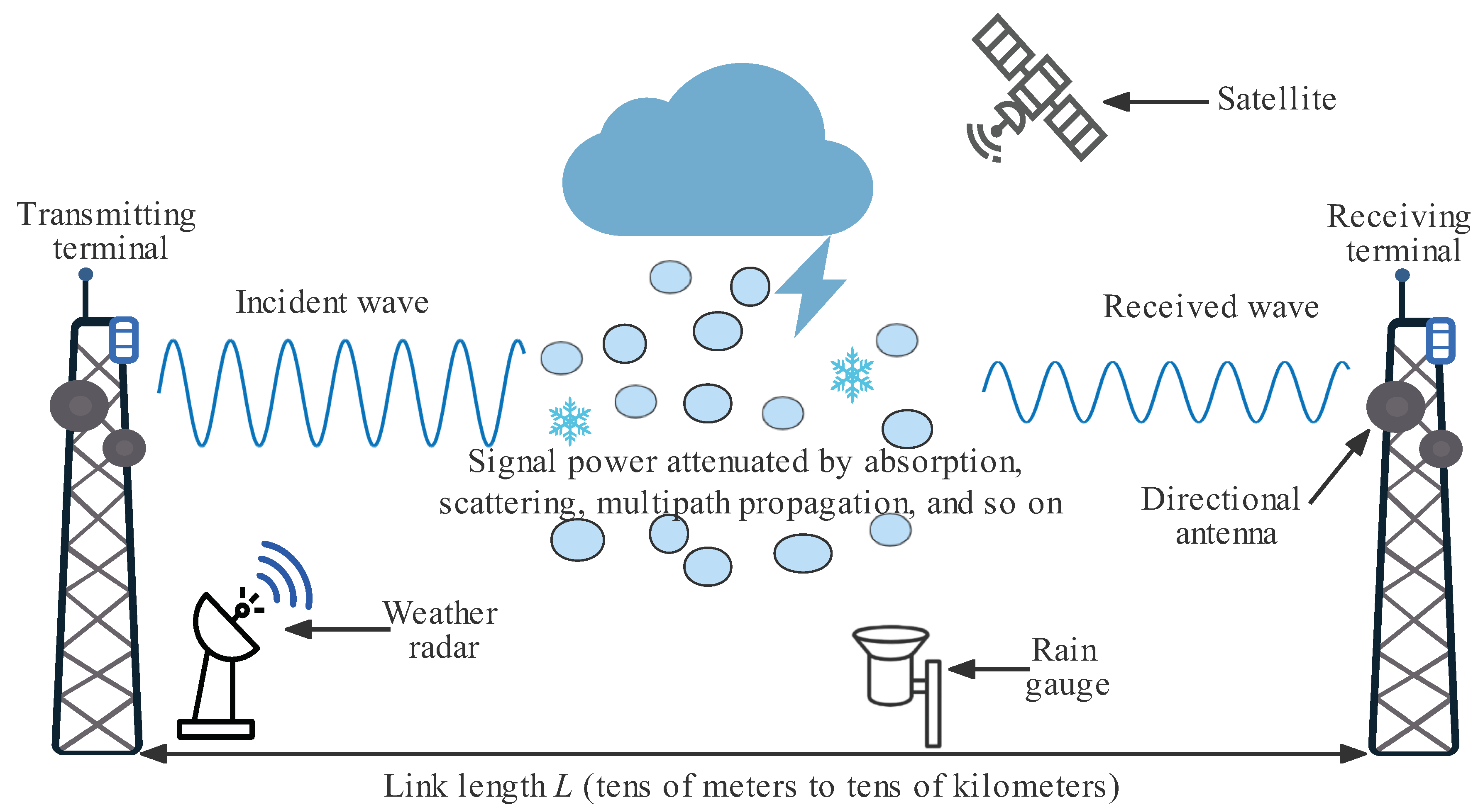
Figure 1. Basic operating principle of CML-based rainfall measurement.
2.2. Mathematical Models
The amount of signal attenuation, denoted as Atot (dB), is obtained by subtracting the received power from the transmitting power. Here, Atot comprises three types of attenuations, i.e., baseline attenuation Abaseline (dB), path-integrated rain attenuation Arain (dB), and wet antenna attenuation AWAA (dB). That is,
2.2.1. Baseline Attenuation
Abaseline is usually determined by the attenuation value in a time interval right before a rainfall event and mainly consists of free space path loss Abf (dB) and atmospheric attenuation Agas (dB), i.e.,
-
Free-space path loss Abf. The free-space path loss is the loss of signal strength when a signal propagates through free space. Free-space path loss Abf increases as the distance between the transmitter and the receiver increases. According to Recommendation ITU-R P.525-4 [30], when the distance between antennas is much larger than the electromagnetic wavelength λ, the path loss of electromagnetic wave in free space is only related to the frequency and distance, as shown in Equation (4):where f (MHz) is carrier frequency and L (km) is the distance between the transmitter and the receiver.
-
Atmospheric attenuation Agas. When electromagnetic waves propagate through the atmosphere, they will be attenuated by the absorption, reflection, and scattering of water vapor, fog, solid particles, oxygen, nitrogen, carbon dioxide, and other substances in the atmosphere. According to Recommendation ITU-R P.676-12 [31], the specific gaseous attenuation of a microwave link, denoted as kgas (dB/km), can be estimated bywhere ko and kw (dB/km) are the specific attenuation caused by dry air (oxygen, nitrogen, etc.) and water vapor, respectively, and N′′oxygen and N′′watervapour are the imaginary parts of the frequency-dependent complex refractivities. Then, the atmospheric attenuation of a microwave link can be estimated by
2.2.2. Path-Integrated Rain Attenuation
According to refs. [5][10][19], path-integrated rain attenuation Arain in Equation (2) basically is a function of the specific attenuation k, which can be calculated based on Equation (1), that is,
where R (mm/h) is the path-average rain rate. The attenuation caused by rainfall and the average rain rate are linearly correlated if b≈ 1. Other than Equation (1), the values of the rain rate R and the specific attenuation k can be estimated based on DSD refer to [32][33], i.e.,
where D is the raindrop diameter in mm, N(D) is the DSD’s number concentration per diameter in mm−1m−3, v(D) is the rain droplet final velocity in m/s, and Cext(D,f) is the extinction cross section at frequency f in m2, which describes the attenuation of the signal at frequency f by each raindrop. The dependence of Cext(D,f) and v(D)D1 on raindrop diameter D is very similar, especially in the frequency range from 20 GHz to 35 GHz [5].
2.2.3. Wet Antenna Attenuation (WAA)
WAA (AWAA) refers to the signal attenuation due to the water film attached to the radome during the rainfall, and it will last for a period of time until the water on the radome evaporates. Because Abaseline is determined prior to the rainfall event, WAA is generally not included in Abaseline. Usually, WAA is assumed as a constant value (1–2 dB) or determined by the RSL time series of the link and its surrounding links in the previous time, and the time probability distribution function of WAA can also be estimated by data-driven algorithms.
2.3. Example Demonstration
Figure 2 shows the relationship between the total attenuation of the CML and the rainfall intensity measured by RG. The simulation data come from an open access dataset [34], which contains the signal power total loss collected from six E-band (71–76 GHz and 81–86 GHz) CMLs and the rainfall intensity collected from four RGs in Prague, Czech Republic. The data from one CML of the six and one RG, which is nearest to the selected link midpoint, to generate the signal level time series of 24 h (23 August 2018 19:39–24 August 2018 19:39) with a time resolution of 1 min. It can be seen that there is a clear correlation between CML power total loss and rainfall intensity, and even very low intensity rainfall can be perceived by the CML measurement, because the E-band CML is more sensitive to rainfall than other used frequency bands (roughly from 10 to 50 GHz) at present [35][36].
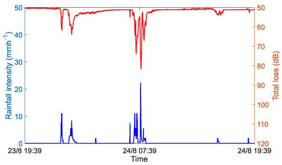
Figure 2. Correlation between CML power total loss and rainfall intensity.
3. Development of Rainfall Measurement Based on CML
In the middle of the 20th century, it was found that rainfall had a significant impact on the attenuation of electromagnetic waves, especially high-frequency electromagnetic waves, and it was proposed that the attenuation of electromagnetic waves could be used to retrieve rainfall intensity [37]. At the end of the 20th century, the implementation of the Tropical Rainfall Measuring Mission (TRMM) project has promoted a series of experiments to retrieve DSD by using dedicated dual-frequency links [38]. However, it is not realistic to deploy such a network of microwave links just for rain measurement in a large area. Fortunately, since the beginning of the 21st century, with the rapid growth number of mobile phone users, a variety of wireless base stations and microwave links have been widely deployed to build seamless WCNs. This forms the infrastructure foundation of the CML-based rainfall monitoring networks to timely observe rainfall with high temporal and spatial resolution. Each microwave link between two base stations is equivalent to a sensor node. Moreover, for the typical frequencies used by CML in WCNs, the coefficient b in Equation (1) is very close to 1, which means that there is a good linear relationship between rain-induced attenuation and rainfall intensity. In 2006, Messer et al. [39] used CML-RSL data to retrieve the rainfall intensity in Israel for the first time. In 2013, Overeem et al. [40] used an unprecedented number of more than 2400 CMLs to reconstruct the rainfall map for the entirety of the Netherlands (35,500 km2). Subsequently, countries around the world established research teams and tried to explore the potential of CML in the field of environmental monitoring. Table 2 summarizes the countries that have achieved rainfall measurement by CML in chronological order.
Table 2. Countries that have used CML to measure rainfall.
| CML Data | |||||||
|---|---|---|---|---|---|---|---|
| Authors (Year) | Country | Frequency (GHz) | Link Number | Length (km) | Temporal | Quantization Level (dB) | Remarks |
| Messer et al. (2006) [39] | Israel | — | — | — | 15 min | — | The correlation between rainfall intensity measured by CML and RG is 0.86 for a 15 min interval and 0.9 for an hourly interval. |
| Leijnse et al. (2007) [41] | The Netherlands | 38 | 2 | 7.75, 6.72 | 15 min | 1 | Eight rainfall events are evaluated, and the results are consistent with the rainfall retrieved from RGs and C-band radar. |
| Schleiss et al. (2010) [42] | France | 26, 19 | 4 | 3.7, 3.7, 7.1, 2.4 | 30s, 6s | 1 | A wet and dry weather classification method is proposed, which can identify 92% of all rainy periods and 93% of the total rain amount. |
| Chwala et al. (2012) [43] | Germany | 15, 18.7, 23 | 5 | 17.4, 10.2, 4, 17.1, 10.4 | selectable | <0.05 | A new algorithm based on short-time Fourier transform (STFT) is proposed for the wet/dry classification. The correlation reaches 0.81 for the link-gauge comparison. |
| Bianchi et al. (2013) [44] | Switzerland | 23, 38, 58 | 14 | 0.3–8.4 | 5 min | 0.1 or 1 | RGs, weather radar and CMLs are combined to estimate the intensity and temporal distribution of rainfall more accurately. |
| Fencl et al. (2013) [45] | Czech Republic |
38 | 14 | — | — | — | CML networks can better capture the spatio-temporal rainfall dynamics, especially in heavy rain, and thus improve pipe flow prediction. |
| Doumounia et al. (2014) [46] |
Burkina Faso | 7 | 1 | 29 | 1s | 1 | 95% of the rainy days are detected by CML measurement, and the correlation with the RGs data series is 0.8. |
| D’Amico et al. (2016) [47] | Italy | 25 | 3 | average of 6 | — | — | Tomographic technique was applied to reconstruct 2-D fields of rainfall accumulation, and the link density and topology affect the accuracy of the reconstruction algorithm. |
| Rios Gaona et al. (2018) [48] | Brazil | above 15 | 145 | shorter than 20 | — | 0.1 | As compared to RGs, CML-based measurement can better capture the city-average rainfall dynamics. |
| Sohail Afzal et al. (2018) [49] | Pakistan | 38 | 35 | 0.5–2.5 | 15 min | — | The correlation coefficient value between rainfall intensity measured by CMLs and RGs is as high as 0.97. |
| Jacoby et al. (2020) [50] | Sweden | 14–39 | 17 | 1.5–7 | 10 s | — | Using long short-term memory (LSTM) to learn from previous attenuation values is sufficient to generate accurate attenuation predictions. |
| Song et al. (2021) [51] | China | 15–23 | 8 | 0.55–1.08 | 1 min | 0.1 | The correlation coefficient values between the rain rate measured by CMLs and RGs are all higher than 0.77, and the highest coefficient is over 0.9. |
| Pudashin et al. (2021) [52] | Australia | 10–40 | 144 | 0.2–57 | 15 min | 0.1 | Using two types of datasets collected by different sampling strategies (maximum/minimum RSL and average RSL) to retrieve rainfall, the results show that the maximum/minimum RSL data are better than average in terms of the statistics, i.e., root mean square error (RMSE), bias, and coefficient of variation (CV). |
"—" represents that the content is not mentioned in the literature.
References
- Messer, H.; Sendik, O. A New Approach to Precipitation Monitoring: A Critical Survey of Existing Technologies and Challenges. IEEE Signal Process. Mag. 2015, 32, 110–122.
- Office of State Flood Control and Drought Relief Headquarters. National Flood Prevention and Drought Relief Work in 2021. China Flood Drought Manag. 2022, 32, 1–4. Available online: http://www.cfdm.cn/CN/10.16867/j.issn.1673-9264.2022024 (accessed on 17 May 2022).
- Pudashine, J. Improved Rainfall Measurement Using Microwave Links. Ph.D. Thesis, Monash University, Melbourne, Australia, March 2021.
- Lindersson, S.; Brandimarte, L.; Mård, J.; di Baldassarre, G. A Review of Freely Accessible Global Datasets for the Study of Floods, Droughts and Their Interactions with Human Societies. WIREs Water 2020, 7, e1424.
- Chwala, C.; Kunstmann, H. Commercial Microwave Link Networks for Rainfall Observation: Assessment of the Current Status and Future Challenges. WIREs Water 2019, 6, e1337.
- Samad, M.A.; Diba, F.D.; Choi, D.Y. A Survey of Rain Attenuation Prediction Models for Terrestrial Links: Current Research Challenges and State-of-the-Art. Sensors 2021, 21, 1207.
- Sokol, Z.; Szturc, J.; Orellana-Alvear, J.; Popová, J.; Jurczyk, A.; Célleri, R. The Role of Weather Radar in Rainfall Estimation and Its Application in Meteorological and Hydrological Modelling—A Review. Remote Sens. 2021, 13, 351.
- Germann, U.; Boscacci, M.; Clementi, L.; Gabella, M.; Hering, A.; Sartori, M.; Sideris, I.V.; Calpini, B. Weather Radar in Complex Orography. Remote Sens. 2022, 14, 503.
- Kidd, C.; Huffman, G.; Maggioni, V.; Chambon, P.; Oki, R. The Global Satellite Precipitation Constellation Current Status and Future Requirements. Bull. Am. Meteorol. Soc. 2021, 102, E1844–E1861.
- Uijlenhoet, R.; Overeem, A.; Leijnse, H. Opportunistic Remote Sensing of Rainfall Using Microwave Links from Cellular Communication Networks. WIREs Water 2018, 5, e1289.
- IMT-2030 (6G) Promotion Group. Research Report of the Integration of Communications and Sensing. Beijing, China, September 2021, pp. 1–54. Available online: https://mp.weixin.qq.com/s/2Wq0Cf2DW57R5nAaRZlS3w (accessed on 17 May 2022).
- Chaccour, C.; Soorki, M.N.; Saad, W.; Bennis, M.; Popovski, P.; Debbah, M. Seven Defining Features of Terahertz (THz) Wireless Systems: A Fellowship of Communication and Sensing. IEEE Commun. Surv. Tutor. 2021, in press.
- Han, C.; Huo, J.; Gao, Q.; Su, G.; Wang, H. Rainfall Monitoring Based on Next-Generation Millimeter-Wave Backhaul Technologies in a Dense Urban Environment. Remote Sens. 2020, 12, 1045.
- Du, R.; Santi, P.; Xiao, M.; Vasilakos, A.V.; Fischione, C. The Sensable City: A Survey on the Deployment and Management for Smart City Monitoring. IEEE Commun. Surv. Tutor. 2019, 21, 1533–1560.
- Diba, F.D.; Samad, M.A.; Choi, D.Y. The Effects of Rain on Terrestrial Links at K, Ka and E-Bands in South Korea: Based on Supervised Learning. IEEE Access 2021, 9, 9345–9355.
- Berne, A.; Uijlenhoet, R. Path-Averaged Rainfall Estimation Using Microwave Links: Uncertainty Due to Spatial Rainfall Variability. Geophys. Res. Lett. 2007, 34, L07403.
- Shen, C. A Transdisciplinary Review of Deep Learning Research and Its Relevance for Water Resources Scientists. Water Resour. Res. 2018, 54, 8558–8593.
- Reichstein, M.; Camps-Valls, G.; Stevens, B.; Jung, M.; Denzler, J.; Carvalhais, N. Deep Learning and Process Understanding for Data-Driven Earth System Science. Nature 2019, 566, 195–204.
- Messer, H. Capitalizing on Cellular Technology—Opportunities and Challenges for near Ground Weather Monitoring. Environments 2018, 5, 73.
- Christofilakis, V.; Tatsis, G.; Chronopoulos, S.K.; Sakkas, A.; Skrivanos, A.G.; Peppas, K.P.; Nistazakis, H.E.; Baldoumas, G.; Kostarakis, P. Earth-to-Earth Microwave Rain Attenuation Measurements: A Survey on the Recent Literature. Symmetry 2020, 12, 1440.
- ITU-R: Recommendation ITU-R, P. 341-7: The Concept of Transmission Loss for Radio Links. 2019. Available online: https://www.itu.int/dms_pubrec/itu-r/rec/p/R-REC-P.341-7-201908-I!!PDF-E.pdf (accessed on 19 April 2022).
- Zhao, Y.; Liu, X.; Xian, M.; Gao, T. Statistical Study of Rainfall Inversion Using the Earth-Space Link at the Ku Band: Optimization and Validation for 1 Year of Data. IEEE J. Sel. Top. Appl. Earth Obs. Remote Sens. 2021, 14, 9486–9494.
- ITU-R: Recommendation ITU-R, P. 838-3: Specific Attenuation Model for Rain for Use in Prediction Methods. 2005. Available online: https://www.itu.int/dms_pubrec/itu-r/rec/p/R-REC-P.838-3-200503-I!!PDF-E.pdf (accessed on 19 April 2022).
- Fencl, M.; Rieckermann, J.; Sýkora, P.; Stránský, D.; Bareš, V. Commercial Microwave Links Instead of Rain Gauges: Fiction or Reality? Water Sci. Technol. 2015, 71, 31–37.
- Polz, J.; Graf, M.; Chwala, C. Missing Rainfall Extremes in CML Data Due to Total Loss. Earth Space Sci. Open Arch. 2022, in press.
- Su, G.; Han, C.; Bi, Y.; Liu, K.; Bao, L. Monitoring and Analysis of Water Vapor Density Based on Wireless Communication Network in Gothenburg Area. J. Infrared Millim. Waves 2020, 39, 47–55.
- Han, C.; Su, G.; Bao, L.; Messer, H. Water Vapor Density Retrieval Studies Using Commercial Millimeter-Wave Links at 38 GHz and E-Band. Remote Sens. 2022, 14, 946.
- Song, K.; Liu, X.; Gao, T.; Zhang, P. Estimating Water Vapor Using Signals from Microwave Links below 25 Ghz. Remote Sens. 2021, 13, 1409.
- Ostrometzky, J.; Cherkassky, D.; Messer, H. Accumulated Mixed Precipitation Estimation Using Measurements from Multiple Microwave Links. Adv. Meteorol. 2015, 2015, 707646.
- ITU-R: Recommendation ITU-R, P. 525-4: Calculation of Free-Space Attenuation. 2019. Available online: https://www.itu.int/dms_pubrec/itu-r/rec/p/R-REC-P.525-4-201908-I!!PDF-E.pdf (accessed on 19 April 2022).
- ITU-R: Recommendation ITU-R, P. 676-12: Attenuation by Atmospheric Gases and Related Effects. 2019. Available online: https://www.itu.int/dms_pubrec/itu-r/rec/p/R-REC-P.676-12-201908-I!!PDF-E.pdf (accessed on 19 April 2022).
- Song, K.; Liu, X.; Gao, T.; He, B. Rainfall Estimation Using a Microwave Link Based on an Improved Rain-Induced Attenuation Model. Remote Sens. Lett. 2019, 10, 1057–1066.
- Han, C.; Feng, L.; Huo, J.; Deng, Z.; Zhang, G.; Ji, B.; Zhou, Y.; Bi, Y.; Duan, S.; Yuan, R. Characteristics of Rain-Induced Attenuation over Signal Links at Frequency Ranges of 25 and 38 Ghz Observed in Beijing. Remote Sens. 2021, 13, 2156.
- Fencl, M.; Dohnal, M.; Valtr, P.; Grabner, M.; Bareš, V. Atmospheric Observations with E-Band Microwave Links-Challenges and Opportunities. Atmos. Meas. Tech. 2020, 13, 6559–6578.
- Zheng, S.; Han, C.; Huo, J.; Cai, W.; Zhang, Y.; Li, P.; Zhang, G.; Ji, B.; Zhou, J. Research on Rainfall Monitoring Based on E-Band Millimeter Wave Link in East China. Sensors 2021, 21, 1670.
- Wang, Q. Research on Millimeter Wave Channel Propagation Characteristics in 5G Topical Frequency Bands and Scenarios. Ph.D. Thesis, North China Electric Power University, Beijing, China, June 2018.
- Stratton, J. The Effect of Rain and Fog on The Propagation of Very Short Radio Waves. Proc. Inst. Radio Eng. 1930, 18, 1064–1073.
- Rincon, R.; Lang, R. Microwave Link Dual-wavelength Measurements of Path-average Attenuation for the Estimation of Drop Size Distributions and Rainfall. IEEE Trans. Geosci. Remote Sens. 2002, 40, 760–770.
- Messer, H.; Zinevich, A.; Alpert, P. Environmental Monitoring by Wireless Communication Networks. Science 2006, 312, 713.
- Overeem, A.; Leijnse, H.; Uijlenhoet, R. Country-Wide Rainfall Maps from Cellular Communication Networks. Proc. Natl. Acad. Sci. USA 2013, 110, 2741–2745.
- Leijnse, H.; Uijlenhoet, R.; Stricker, J. Rainfall Measurement Using Radio Links from Cellular Communication Networks. Water Resour. Res. 2007, 43, W03201.
- Schleiss, M.; Berne, A. Identification of Dry and Rainy Periods Using Telecommunication Microwave Links. IEEE Geosci. Remote Sens. Lett. 2010, 7, 611–615.
- Chwala, C.; Gmeiner, A.; Qiu, W.; Hipp, S.; Nienaber, D.; Siart, U.; Eibert, T.; Pohl, M.; Seltmann, J.; Fritz, J.; et al. Precipitation Observation Using Microwave Backhaul Links in the Alpine and Pre-Alpine Region of Southern Germany. Hydrol. Earth Syst. Sci. 2012, 16, 2647–2661.
- Bianchi, B.; van Leeuwen, P.; Hogan, R.; Berne, A. A Variational Approach to Retrieve Rain Rate by Combining Information from Rain Gauges, Radars, and Microwave Links. J. Hydrometeorol. 2013, 14, 1897–1909.
- Fencl, M.; Rieckermann, J.; Schleiss, M.; Stránský, D.; Bareš, V. Assessing the Potential of Using Telecommunication Microwave Links in Urban Drainage Modelling. Water Sci. Technol. 2013, 68, 1810–1818.
- Doumounia, A.; Gosset, M.; Cazenave, F.; Kacou, M.; Zougmore, F. Rainfall Monitoring Based on Microwave Links from Cellular Telecommunication Networks: First Results from a West African Test Bed. Geophys. Res. Lett. 2014, 41, 6016–6022.
- D’Amico, M.; Manzoni, A.; Solazzi, G. Use of Operational Microwave Link Measurements for the Tomographic Reconstruction of 2-D Maps of Accumulated Rainfall. IEEE Geosci. Remote Sens. Lett. 2016, 13, 1827–1831.
- Rios Gaona, M.F.; Overeem, A.; Raupach, T.H.; Leijnse, H.; Uijlenhoet, R. Rainfall Retrieval with Commercial Microwave Links in São Paulo, Brazil. Atmos. Meas. Tech. 2018, 11, 4465–4476.
- Sohail Afzal, M.; Shah, S.H.H.; Cheema, M.J.M.; Ahmad, R. Real Time Rainfall Estimation Using Microwave Signals of Cellular Communication Networks: A Case Study of Faisalabad, Pakistan. Hydrol. Earth Syst. Sci. Discuss. 2018, 1–20.
- Jacoby, D.; Ostrometzky, J.; Messer, H. Short-Term Prediction of the Attenuation in a Commercial Microwave Link Using LSTM-Based RNN. In Proceedings of the 2020 28th European Signal Processing Conference (EUSIPCO), Amsterdam, The Netherlands, 18–21 January 2021.
- Song, K.; Liu, X.; Gao, T. Real-Time Rainfall Estimation Using Microwave Links: A Case Study in East China during the Plum Rain Season in 2020. Sensors 2021, 21, 858.
- Pudashine, J.; Guyot, A.; Overeem, A.; Pauwels, V.R.N.; Seed, A.; Uijlenhoet, R.; Prakash, M.; Walker, J.P. Rainfall Retrieval Using Commercial Microwave Links: Effect of Sampling Strategy on Retrieval Accuracy. J. Hydrol. 2021, 603, 126909.
More
Information
Subjects:
Remote Sensing
Contributors
MDPI registered users' name will be linked to their SciProfiles pages. To register with us, please refer to https://encyclopedia.pub/register
:
View Times:
1.9K
Entry Collection:
Environmental Sciences
Revisions:
2 times
(View History)
Update Date:
29 Jun 2022
Table of Contents


Notice
You are not a member of the advisory board for this topic. If you want to update advisory board member profile, please contact office@encyclopedia.pub.
OK
Confirm
Only members of the Encyclopedia advisory board for this topic are allowed to note entries. Would you like to become an advisory board member of the Encyclopedia?
Yes
No
${ textCharacter }/${ maxCharacter }
Submit
Cancel
Back
Comments
${ item }
|
${ item.createdUser.fullName }
${ item.createdAt }
${ item.vote }
${ item.reply }
Delete
${ reply.createdUser.fullName }
${ reply.createdAt }
${ reply.vote }
Delete
There is no reply to this comment~
${ item.replyTextCharacter }/${ item.replyMaxCharacter }
Submit
Cancel
More
No more~
There is no comment~
${ textCharacter }/${ maxCharacter }
Submit
Cancel
${ selectedItem.replyTextCharacter }/${ selectedItem.replyMaxCharacter }
Submit
Cancel
Confirm
Are you sure to Delete?
Yes
No