Your browser does not fully support modern features. Please upgrade for a smoother experience.
Submitted Successfully!
 +1 credit
Thank you for your contribution! You can also upload a video entry or images related to this topic.
For video creation, please contact our Academic Video Service.
| Version | Summary | Created by | Modification | Content Size | Created at | Operation |
|---|---|---|---|---|---|---|
| 1 | Hao Li | + 4158 word(s) | 4158 | 2021-12-22 02:54:37 |
Video Upload Options
We provide professional Academic Video Service to translate complex research into visually appealing presentations. Would you like to try it?
Cite
If you have any further questions, please contact Encyclopedia Editorial Office.
Li, H. Snow-Disaster Risk Zoning and Assessment in Heilongjiang Province. Encyclopedia. Available online: https://encyclopedia.pub/entry/18468 (accessed on 18 June 2026).
Li H. Snow-Disaster Risk Zoning and Assessment in Heilongjiang Province. Encyclopedia. Available at: https://encyclopedia.pub/entry/18468. Accessed June 18, 2026.
Li, Hao. "Snow-Disaster Risk Zoning and Assessment in Heilongjiang Province" Encyclopedia, https://encyclopedia.pub/entry/18468 (accessed June 18, 2026).
Li, H. (2022, January 19). Snow-Disaster Risk Zoning and Assessment in Heilongjiang Province. In Encyclopedia. https://encyclopedia.pub/entry/18468
Li, Hao. "Snow-Disaster Risk Zoning and Assessment in Heilongjiang Province." Encyclopedia. Web. 19 January, 2022.
Copy Citation
Heilongjiang Province is located in Northeast China and has the highest latitude in China. It has a long and cold winter and a mild monsoon climate. The unique geographical location and climatic conditions make it the second largest stable snow area in China. The winter snowfall period begins in October and ends in April of the next year. Therefore, long-term snow has caused road obstruction and low-temperature freezing damage, which has seriously affected local economic development and personal safety.
snow disaster
risk assessment
risk zoning
Heilongjiang Province
1. Introduction
Since the 1990s, the focus of emergency management has gradually turned from emergency rescue and postevent recovery and reconstruction, to prepreventive preparations [1]. The United States, Britain, Germany, France, Japan, and other countries have promoted major disaster risk assessments. In 2004, the United Nations International Strategy for Disaster Reduction (UNISDR) and the United Nations Development Programme (UNDP) released two reports, respectively titled: “Living with Risk: A Global Review of Disaster Reduction Initiatives”, and “Disaster risk reduction: a development concern”. In March 2015, the “Sendai Framework for Disaster Risk Reduction 2015–2030”, finally adopted by the Third World Conference on Disaster Risk Reduction, pointed out that two of the four priorities for disaster reduction are “Understanding disaster risk” and “Strengthening disaster risk governance to manage disaster risk” [2][3]. A snow disaster is large-scale snow, caused by heavy snowfall, which seriously affects the survival and health of humans and livestock. It is a meteorological disaster that can affect and damage traffic, communications, agriculture, and electricity [4]. In 1977, the snow disaster in Xilingol (Inner Mongolia) caused more than 70% of livestock deaths [5]. From 2000 to 2012, the agriculture sector of Liaoning Province suffered 20 large-scale disasters resulting from snowstorms [6]. In 2008, the 100-year snow disaster swept over half of China, and affected circuits, communications, the water supply, and heating, to different degrees. According to statistics, the snow disaster caused 129 deaths; the emergency resettlement of 1.66 million people; 485,000 house collapses; and 178 million mu of crop damage; and resulted in direct economic losses of CNY 151.65 billion. The heavy snow in Heilongjiang Province in 2007 caused 754 houses to collapse. Local snowstorms affected more than 900 people in Suifenhe City and other places, with direct economic losses of nearly CNY 100 million [7]. It is evident that snow disasters have had a huge impact on human society. Therefore, snow-disaster risk assessment provides an important theoretical basis for predisaster preparations, as well as for scientifically setting the meteorological disaster prevention standards for various regional infrastructures, which is more conducive to promoting the construction of resilient cities and villages, and to fundamentally improving the ability to resist snow disasters.
Snow disasters occur in various forms, such as snow melting leading to avalanches and ice floods, less (more) snow leading to black (white) disasters, and abnormal snowfall in windy weather leading to snowstorms. The existing studies on snow-disaster risk mainly focus on three aspects: (1) Studies on single snow-disaster risks. Some scholars have evaluated the avalanche risk. Schmitt et al. assessed the avalanche risk on the Alps on the basis of topographical parameters, such as slope, aspect and elevation, forestry-related variables, and rocks [8]. Seliverstov et al. [9] carried out avalanche risk zoning in Russia on the basis of the recurrence interval of avalanches (avalanche frequency), the percentage of the whole investigated territory that is occupied by avalanche-prone areas, the duration of the avalanche danger period, the probability of a person’s stay in an avalanche-prone area for 1 day (24 h) and for 1 year, and the total population of the area and its density. Cappabianca et al. [10] presented an avalanche risk estimation procedure that combines a statistical analysis of the snowfall record, iterative simulations of avalanche dynamics, and empirically based vulnerability relations. Germain et al. [11] reconstructed past avalanche events in the north of the Gaspe Peninsula on the basis of tree rings and assessed the avalanche risk. In 2016, Germain also analyzed the avalanche risk from natural factors, the population, and environmental factors for avalanche disaster in northern Quebec, eastern Canada [12]. Some scholars have studied the risk of snowstorm disasters. Zhang et al. [13] calculated the probability of each level of the snowstorm information diffusion theory on the basis of the daily snow precipitation in 63 cities and counties in Heilongjiang Province, China, from 1961 to 2015, and established a hazard index model by using the snowstorm probability and the amount of snow precipitation. Next, a hazard assessment and the regionalization of snowstorms was performed for Heilongjiang Province from 1961 to 2015, and it was proposed that the high-risk areas increased by 30.7% from the 1960s to the 2010s, as opposed to the 38.9% reduction in the low-risk areas. Liu et al. [14] constructed the snowstorm disaster risk index on the basis of the frequency of snowstorms and assessed and regionalized the snowstorm risk in northeast China in the future (2020–2099). They showed that, under the RCP4.5 and RCP8.5 scenarios, the areas of the high-risk and light-risk regions would increase, while the areas of the low- and medium-risk regions would decrease. (2) Studies on the impact of snow disasters. Snow disasters have a major impact on agriculture, animal husbandry, and road transportation. Barbolini et al. [15], on the basis of avalanche accidents that occurred during outdoor winter activities over the Italian Alps in the last 20 years, proposed a vulnerability relation for people directly exposed to avalanches. Sinickas et al. [16] discussed the effects of the long-term changes in the avalanche occurrence rates in terms of consequences and vulnerability. Casteller et al. [17] report on the relationship between Nothofagus broadleaf forests and avalanche runout distances. Gao [18] constructed an agricultural risk estimation index and divided the risks of China’s ice and snow on agriculture. Their results propose that the regions with high snow and freezing occurrences are located in northwestern China, and that the regions with the high-loss areas are located in the coastal and southeastern parts. Sa et al. [19] established a snow-cover index using passive microwave remote sensing data from 1978 to 2012, and evaluated the risk factors of disaster in the pastoral areas of the Inner Mongolia Grasslands. Liu et al. [20] constructed the snow-disaster index and the vulnerability index by using the highway network, social and economic development data, meteorology data, and ArcGIS software of Guoluo Prefecture, Qinghai Province, combined with the analytic hierarchy process (AHP) and cluster analysis, to calculate the snow-road-disaster risk index of Guoluo Prefecture. Qi et al. [21] proposed the risk assessment index system of highway snow cover on the basis of a theoretical model and put forward a distribution of trunk highway snow-disaster risks in Shaanxi. Leone et al. [22] evaluated the impact of avalanches on road traffic in three Alpine departments (Alpes-de-Haute-Provence, Hautes-Alpes, and Alpes-Maritimes). Snow disasters can also amplify the effects of other disasters, such as earthquakes [23]. (3) Studies on the comprehensive risk regionalization of snow disasters. Wang et al. [24] further analyzed the formation mechanism of snow disasters (SDs), and constructed the integrated risk index (IRI) of a snow disaster from the aspects of historical disasters, snowfall events, disaster-formation environments, livestock overload, and livestock vulnerability and adaptability. The regions with high IRIs are mainly concentrated in the middle, east, and southwest of the Qinghai-Tibet Plateau, and appear as a contiguous risk belt from northeast to southwest. Liu et al. [25] conducted a comprehensive analysis of the 18 indexes of snow disaster on the Qinghai-Tibet Plateau, based on the hazard harmfulness data collected from historical records and the data collected from the entities affected by this hazard in 2010, and classified the snow-disaster hazards. Gao et al. [26], on the basis of the logistic regression of 33 snow-disaster events in Qinghai province, with the maximum snow depths, snow-cover days (SCDs), slopes, annual average temperatures, and per capita gross domestic product (GDP), constructed a potential risk assessment model to regionalize the snow-disaster risk in Qinghai Province. Park et al. [27] selected the pressure index (PI), the state index (SI), and the response index (RI) to assess the comprehensive risk of snow disaster in the metropolitan city of Ulsan. Insang [28] also assessed and analyzed the snow disaster risks of Daegu City, Ulsan City, Gyeongsangbuk Province, and Gangwon Province on the basis of the subindicators of three hazards, six exposures, four vulnerabilities, and five adaptive capacities.
2. Snow-Disaster Risk Analysis
2.1. The Characteristics of the Risk Zoning Factors of Snow Disasters in Heilongjiang Province
In this paper, the snow depth, the length of the snow-cover period, the snowfall intensity, the total blizzard volume, the total number of blizzards, and the total days of wind speeds over 8 m/s were selected as the risk factors of snow disaster. The deeper the snow depth, the longer the snow-cover period, the stronger the snowfall intensity, the greater the blizzards, the greater the total number of blizzards, and the more days with wind speeds over 8 m/s, the greater the risk of snow disasters. Figure 1 shows the interannual variation characteristics of the snow depth, the snow-period length, the snow intensity, the total blizzard volume, the total number of blizzards, and the days with wind speeds over 8 m/s in Heilongjiang Province, from 1983 to 2020. It can be seen that the snow depth, snow intensity, total blizzard volume, and the total number of blizzards in Heilongjiang Province show a significant increase, and the M–K statistics are 2.869, 3.269, 1.968, 2.014, respectively. The length of the snow-cover period and the wind speeds showed a significant decrease, and the M–K statistical values were −3.223 and −6.43 (Table 1). It can be seen from the distribution of the box map (Figure 2) that the snow depth, the snow-period length, the snow intensity, the total blizzard volume, the total number of blizzards, and the days with average wind speeds over 8 m/s are 20.82 cm, 165.4 d, 1.24 cm/time, 142.0 mm, 9.9 times, and 92 d, respectively. The interannual changes in the wind speed, snow intensity, the number of blizzards, and the snow depth are relatively large, while the interannual changes in the snow depth and the blizzard volume are relatively small. It can be seen from the extreme value distribution characteristics that the maximum value of the snow intensity, the maximum value of the blizzard volume, and the number of blizzards are obviously larger than the average values, while the minimum value of the days with wind speeds over 8 m/s is obviously smaller than the average value. Using the Pettitt method to calculate the mutation year of each hazard factor, it was concluded that the snow depth, the snow-cover length, the snow intensity, and the days with wind speeds over 8 m/s days in Heilongjiang Province all have abrupt changes around the early 2000 s, and the catastrophes of the total snow cover and the total number of snowstorms occur in the middle and late parts of the 2000 s, respectively.
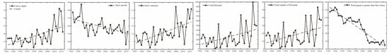
Figure 1. Time variation of risk factors.
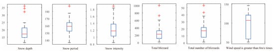
Figure 2. Boxplots of risk factors.
Table 1. The M–K statistics and abrupt years of risk factors.
| Disaster-Causing Factors | Snow Depth |
Snow Period |
Snow Intensity |
Total Blizzard Volume |
Total Number of Blizzards | Wind Speed Is Greater than 8 m/s Times |
|---|---|---|---|---|---|---|
| M–K statistics | 2.867 ** | −3.223 ** | 3.269 ** | 1.968 * | 2.014 * | −6.43 ** |
| Abrupt year | 1999 | 2002 | 1998 | 2005 | 2008 | 2000 |
Figure 3 shows the spatial distribution of the snow depth, the snow-period length, the snow intensity, the total blizzard volume, the total number of blizzards, and the days with wind speeds over 8 m/s in Heilongjiang Province, from 1983 to 2020. It can be seen that the snow depths of Heilongjiang Province, from 1983 to 2015, are between 7.39 and 35.26 cm, and that the snow depths of 25–35.26 cm are mainly distributed in Mohe County in the northwest, northwest of Tahe County, northwest of Huzhong District, Xunke County, Jiayin County, north of Yichun City, north of Hegang City, and north of Luobei County; snow depths of 15–25 cm are mainly distributed in most cities and counties in central and southern Heilongjiang Province; snow depths of 7–15 cm are mainly distributed in the southwest of Heilongjiang Province, including Qiqihar cities and counties, Daqing, and the southwest of Suihua. The length of the snow period in Heilongjiang Province from 1983 to 2015 is 150–200.3 days. Snow periods of more than 180 days are mainly distributed in the Daxing’anling area, in the north of Heilongjiang Province; the areas of snow periods of more than 160 days are mainly distributed in central and northern Heilongjiang Province; the areas with a snow-cover period of less than 160 days are mainly distributed in the southern part of Heilongjiang Province. The length of the snow-cover period of the province generally increases from low latitudes to high latitudes. The snow intensity in Heilongjiang Province from 1983 to 2020 was from 1.23–2.10 cm/time. The areas with higher snow intensities are mainly located in the east of Hegang, Jiamusi, and in Shuangyashan in the east; the areas with moderate snow are mainly located in the east of Heilongjiang Province and Mohe County; and the areas with low snow intensity are mainly distributed in the west of Heilongjiang Province. The total blizzards in Heilongjiang Province from 1983 to 2020 were between 0 and 761.9 mm, and the blizzards above 200 mm were mainly distributed in Jiamusi, Hegang, Shuangyashan, Qitaihe, Jixi, and Mudanjiang, in eastern Heilongjiang Province; the areas with blizzards above 100 mm were mainly distributed in the Yichun, eastern Suihua, eastern Harbin, Mudanjiang, and Daxing’anling regions, in the central part of Heilongjiang Province; the areas with blizzards below 100 mm were mainly distributed in Heihe, Qiqihar, Daqing, Suihua, and Harbin, in the western part of Heilongjiang Province. The total number of blizzards in Heilongjiang Province from 1983 to 2020 was between 5 and 20 times. The total number of blizzards above 15 were mainly located in Jiamusi, Hegang, Shuangyashan, Qitaihe, Jixi, and Mudanjiang, in eastern Heilongjiang Province; the number of blizzards were 10 in the areas mainly distributed in Qiqihar, Daqing, Suihua, and Harbin, in the west of Heilongjiang Province. In Heilongjiang Province, from 1983 to 2020, the number of days with wind speeds over 8 m/s were 70–187.7 days, and the days with wind speeds over 8 m/s over 110 days were mainly distributed in Jiamusi, Hegang, Shuangyashan, Qitaihe, Jixi, and Mudanjiang, in eastern Heilongjiang Province. The areas with wind speeds> 8 m/s within 90–130 days are mainly distributed in the Qiqihar, Daqing, Heihe, and Daxing’anling areas, in western Heilongjiang Province; the areas with wind speeds over 8 m/s below 90 days are mainly distributed in Heihe, Suihua, and Iraq, in central Heilongjiang Province.
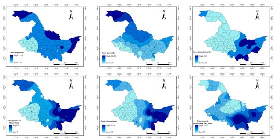
Figure 3. Distribution map of risk factors of snow disaster.
2.2. Results of the Risk Zoning of Snow Disasters in Heilongjiang Province
The spatial superpositions of the risk factors are used to obtain the disaster risk zoning results of snow disasters in Heilongjiang Province (Figure 4a). The spatial distribution of hazards is uneven, and there are high-value areas locally. The risk index is equally divided into three levels (as shown in Table 2), and the spatial distribution of the risk classification is presented in Figure 4b. The spatial distribution of the snow-disaster risk in Heilongjiang Province followed a decreasing trend from east to west. High-risk areas accounted for 46.3% of the entire Heilongjiang area, and were distributed mainly in the eastern region of Heilongjiang (Jiamusi, Yichun, Jixi, Qitaihe, Hegang, Shuangyashan, Xunke, and Mudanjiang) and the northwestern Daxing’anling area; the medium-risk areas covered 36.8% of the entire Heilongjiang area, and were distributed primarily in the central region of Heilongjiang Province (eastern Daxing’anling, Heihe, eastern Suihua, northern Mudanjiang, and eastern Harbin); and the low-risk areas accounted for 16.9% of the total area of Heilongjiang Province, and were distributed mostly in the western region of Heilongjiang Province (Qiqihar, Daqing, western Suihua, and western Harbin).
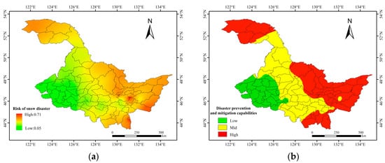
Figure 4. Risk map of snow disaster in Heilongjiang Province ((a): stretch, (b): classification).
Table 2. Risk classification criteria.
| Index | Low | Mid | High |
|---|---|---|---|
| Risk | 0.046–0.244 | 0.244–0.414 | 0.414–0.712 |
| Susceptibility | 0.014–0.129 | 0.129–0.245 | 0.245–0.667 |
| Vulnerability | 0–0.178 | 0.178–0.368 | 0.368–0.824 |
| Prevention and mitigation capacity | 0–0.178 | 0.178–0.280 | 0.280–0.969 |
| Comprehensive Snow Disaster Risk | 0.067–0.295 | 0.295–0.434 | 0.434–0.666 |
3. Susceptibility Analysis of Snow Disaster
3.1. The Characteristics of the Susceptibility Zoning Factors of Snow Disasters in Heilongjiang Province
Figure 5 shows the spatial distribution of the altitude, slope, land-use type, terrain standard deviation, and the NDVI in Heilongjiang Province. It can be seen that the altitude in Heilongjiang province is between 15 and 1651 m; the slope is between 0 and 57.4°; the terrain standard deviation is between 0 and 174.14; and the spatial distribution of the altitude, the slope, and the terrain standard deviation are roughly the same. The areas with high levels are mainly distributed in Huzhong District, Xinlin District, Yichun City, Hailin City, Muling City, and Dongning County in Heilongjiang Province. The land-use types in Heilongjiang Province are dominated by farmland and forest. The forest land is mainly distributed in the Greater Khingan Mountains, in the Lesser Khingan Mountains, and in Mudanjiang City in the south. The NDVI values corresponding to the forest area are also higher, and the highest is 0.83. Farmland is mainly distributed on the Songnen Plain, in the west of Heilongjiang Province, and on the Sanjiang Plain in the east.
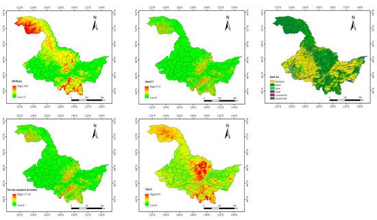
Figure 5. Heilongjiang Province altitude, slope, land-use type, terrain standard deviation, NDVI spatial distribution maps.
3.2. Results of the Susceptibility Zoning of Snow Disasters in Heilongjiang Province
The weight in Table 2 is used to perform the spatial superposition of the susceptibility factors to obtain the susceptibility zoning results of snow disasters in Heilongjiang Province (Figure 6a). The spatial distribution of the snow-disaster susceptibilities in Heilongjiang Province is high in the central and northwestern regions, and is low in the eastern and western regions. The susceptibility index is equally divided into three levels (as shown in Table 2), and the spatial distribution of the susceptibility classification is presented in Figure 6b. High susceptibilities accounted for 16.3% of the entire Heilongjiang area, and were distributed mainly in the northern region (southern Mohe County, Huzhong District, Xinlin District, Yichun City, Tieli City, and Mudanjiang City); medium susceptibilities covered 35.6% of the entire Heilongjiang area, and were distributed largely in the central region of Heilongjiang Province (Heihe City, Huma County, Tahe County, Jixi City, and Yichun); and low susceptibilities accounted for 48.1% of the total area of Heilongjiang Province, and were distributed mainly in the western (Qiqihar, Daqing, Suihua, and Harbin) and eastern (Jiamusi, Shuangyashan, and Jixi) regions of Heilongjiang Province. Heilongjiang Province is located in the Northeast Plain and includes the Songnen Plain and the Sanjiang Plain. Other regions with high susceptibilities were distributed in the Daxinganling, Xiaoxinganling, and Mudanjiang mountainous regions.
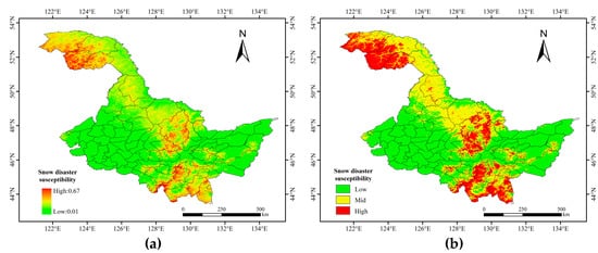
Figure 6. Map of snow-disaster susceptibilities in Heilongjiang Province ((a): stretch, (b): classification).
4. Vulnerability Analysis of Snow Disaster
4.1. The Characteristics of the Vulnerability Zoning Factors of Snow Disasters in Heilongjiang Province
Figure 7 shows the spatial distributions of urban lights, livestock numbers, crop-sown areas, and highway mileages in Heilongjiang. It can be seen that the urban night lights are between 0 and 63, and that the high values of urban night lights are scattered in prefecture-level cities and urban areas, while urban night lights in country-level cities are relatively low. The livestock numbers are from 498 to 665,511, and the areas with high levels are mainly distributed in Longjiang County, Shuangcheng City, and Zhaodong City, in the southwest of Heilongjiang Province. The crop-sown areas are from 214 to 342,188 km2, and the areas with high levels are mainly distributed in Songnen Plain and Sanjiang Plain. The highway mileage is between 92.88 and 25,455, and the areas with high levels are distributed in Qiqihar city, Harbin city, Suihua city, and Heihe city, in Heilongjiang Province.
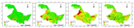
Figure 7. Spatial distributions of urban lights, livestock numbers, crop-sown areas, and highway mileages in Heilongjiang.
4.2. Results of the Vulnerability Zoning of Snow Disasters in Heilongjiang Province
The weight in Table 2 is used to perform the spatial superposition of the vulnerability factors to obtain the vulnerability zoning results of snow disasters in Heilongjiang Province (Figure 8a). The spatial distribution of the snow-disaster vulnerabilities in Heilongjiang Province is high in the western regions, and low in the central and northwestern regions. The vulnerability index is equally divided into three levels, and the spatial distribution of the vulnerability classification is presented in Figure 8b. High vulnerabilities accounted for 3.0% of the entire Heilongjiang area, and were distributed mainly in the economically developed main urban areas (Qiqihar City, Daqing City, Harbin City, and Suihua City), as well as other small parts of cities and counties; medium vulnerabilities constituted about 27.9% of the entire Heilongjiang area, and were distributed chiefly in Heihe City, Nenjiang County, Nehe City, Longjiang County, Zhaodong City, Wuchang City, Fujin City, Baoqing County, and other cities and counties of Heilongjiang Province; and low vulnerabilities accounted for 69.1% of the entire area of Heilongjiang Province, and were distributed mostly in the northern and central regions of Heilongjiang Province. As shown in the figure, high vulnerabilities were distributed mainly in regions with more urban lights and larger populations, which have been significantly affected by disasters.
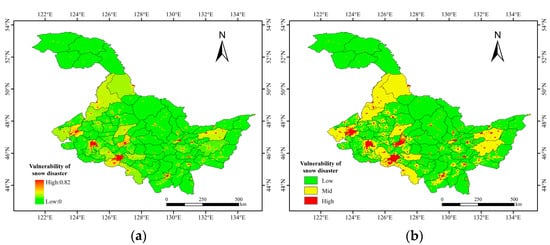
Figure 8. Vulnerability zoning map of snow disaster in Heilongjiang Province ((a): stretch, (b): classification).
5. Analysis of Snow-Disaster Prevention and Mitigation Capability
5.1. The Characteristics of the Prevention and Mitigation Capability Zoning Factors of Snow Disasters in Heilongjiang Province
Socioeconomic factors are the main indicators that affect the disaster prevention and mitigation capability. We selected the economic indicators of the Heilongjiang Province Statistical Yearbook, from 1996 to 2020 that each county has data for, as the factors of the disaster prevention and mitigation capability, and finally selected the total GDP, the per capita disposable income, and the education level. The higher the GDP, the stronger the region’s economic strength, and the stronger its ability to fight disasters. The population size of each region is different, and the per capita disposable income further illustrates the level of economic development. Therefore, the per capita disposable income was selected as the disaster prevention and mitigation ability. The level of education represents the level of awareness of the impacts of, and the defenses against, disasters. Therefore, the higher the level of education, the stronger the ability to reduce disasters.
Figure 9 shows the spatial distributions of the total GDPs, per capita disposable incomes, and education levels in Heilongjiang. It can be seen that the total GDP is between 25,538 and 15,324,071, and that the high values of the total GDPs are mainly distributed in Daqing City, Qiqihar City, and Harbin City. The per capita disposable income is between 2514 and 14,850, and the areas with high levels are mainly distributed in Daqing City, Harbin City, Dongning County, and Hailin City. The education level is between 2300 and 73,770, and the areas with high levels are the same as those with high total GDPs.
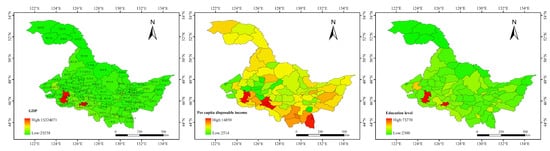
Figure 9. Spatial distributions of total GDPs, per capita disposable incomes, and education levels in Heilongjiang Province.
5.2. Results of the Prevention and Mitigation Capacity Zoning of Snow Disasters in Heilongjiang Province
The weight in Table 2 is used to perform the spatial superposition of the prevention and mitigation capacity factors to obtain the prevention and mitigation capacity zoning results of snow disaster in Heilongjiang Province (Figure 10a). The spatial distribution of the snow-disaster prevention and mitigation capacities in Heilongjiang Province is uneven and is high in the southern regions, and low in the northwestern regions. The prevention and mitigation capacity index is equally divided into three levels, and the spatial distribution of the prevention and mitigation capacity classification is presented in Figure 10b. High disaster prevention and mitigation capabilities accounted for 7.4% of the entire Heilongjiang area, and were distributed mainly in Qiqihar City, Daqing City, Zhaodong City, Hulan District, Harbin City, Acheng District, Shuangcheng City, Mudanjiang City, Jiamusi City, Suifenhe City, and Dongning County; middle disaster prevention and mitigation capabilities constituted 84.0% of the entire Heilongjiang area, and were distributed in most cities and counties in Heilongjiang Province; and low disaster prevention and mitigation capabilities covered 8.6% of the entire Heilongjiang Province area, and were distributed mainly in Sunwu County, Gannan County, Tailai County, Lindian County, Kedong County, Baiquan County, Mingshui County, Qinggang County, Wangkui County, Lanxi County, Suileng County, and Jixi City. The figure shows that the more developed the economy, the stronger the disaster prevention and mitigation capability.
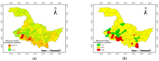
Figure 10. Map of Heilongjiang Province’s snow-disaster prevention and mitigation capacities ((a): stretch, (b): classification).
6. Comprehensive Snow-Disaster Risk Assessment and Zoning
The risk factors, the susceptibility factors, the vulnerability factors, and the prevention and mitigation capacity factors are superimposed, according to the weights, and the comprehensive snow disaster risk index is obtained. The comprehensive risk assessment and zoning results for snow disasters in Heilongjiang Province are shown in Figure 11a. The comprehensive risk index is equally divided into three levels (Table 2), and the spatial distribution of the comprehensive risk classification is presented in Figure 11b.The spatial distribution of the comprehensive snow disaster risk in Heilongjiang Province followed a declining trend from east to west. High risks accounted for 34.3% of the entire Heilongjiang Province area (i.e., an area of 97,000 km2), and were distributed mainly in Hulin City, the eastern part of Mishan City, Shuangyashan City, Qitaihe City, Suifenhe City, Dongning County, Muling City, Ning’an City, Hailin, Mudanjiang City, Yichun City, Jiayin County, Xunke, Hegang, Tangyuan, Jiamusi, Tieli, Mohe County, Huzhong District, Xinlin District, and western Tahe County; medium vulnerabilities covered 45.2% of the Heilongjiang area (i.e., an area of 214,000 km2), largely distributed in eastern Tahe County, Huma County, Heihe City, Nenjiang County, Sunwu County, eastern Wudalianchi, Bei’an, Qing’an, Hailun, Suihua, Mulan, Tonghe, Yilan, Luobei County, Suibin County, Tongjiang City, Fuyuan County, Fujin, Baoqing, Youyi, Jixian, Linkou, Jixi, Jidong, Shangzhi City, and Wuchang City; and low vulnerabilities accounted for 20.5% of the Heilongjiang Province area (i.e., an area of 162,000 km2), and were distributed mostly in the southwestern region of Heilongjiang Province, including Qiqihar, Daqing, western Suihua, and western Harbin.
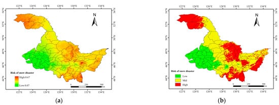
Figure 11. Comprehensive risk zoning map of Heilongjiang snow disaster ((a): stretch, (b): classification).
References
- Zhong, K.B. International Experience and Enlightenment of Comprehensive Disaster Risk Assessment. China Emerg. Manag. 2021, 5, 78–81.
- UN-ISDR. Sendai Framework for Disaster Risk Reduction 2015–2030, International Strategy for Disaster Reduction; United Nations Inter-Agency Secretariat: Geneva, Switherlands, 2015; Available online: www.unisdr.org (accessed on 14 October 2020).
- Wang, P. Research on the zoning method of natural disasters based on GIS. Front. Earth Sci. 2001, 8, 2.
- General Administration of Quality Supervision; Inspection and Quarantine of the People’s Republic of China; Standardization Administration of the People’s Republic of China. GB/T 28921–2012 Natural Disaster Classification and Code; China Standards Press: Beijing, China, 2013.
- Gong, D.J.; Li, Z.J. Causes and mitigation measures of snowstorm disasters in Inner Mongolia. Clim. Environ. Res. 2001, 1, 132–138.
- Chen, Y.Q.; Chen, Y.; Wu, M.L. Characteristic Analysis of Blizzard and Gale Disasters of Liaoning Facility Agriculture. J. Anhui Agric. Sci. 2013, 41, 1660–1661,1692.
- Zhang, J.P. Research on the Spatial and Temporal Distribution and Prevention Technology of Highway Snowstorm Disasters in Heilongjiang Province. Master’s Thesis, Chang’an University, Xi’an, China, 2012.
- Schmitt, U.; Schardt, M.; Ninaus, J. Snow avalanche risk assessment supported by remote sensing Observing Our Environment from Space-New Solutions for a New Millennium. In Proceedings of the 21st EARSel Symposium, Paris, France, 14–16 May 2001; CRC Press: Boca Raton, FL, USA, 2021; pp. 14–16.
- Seliverstov, Y.; Glazovskaya, T.; Shnyparkov, A.; Vilchek, Y.; Sergeeva, K.; Martynov, A. Assessment and mapping of snow avalanche risk in Russia. Ann. Glaciol. 2008, 49, 205–209.
- Cappabianca, F.; Barbolini, M.; Natale, L. Snow avalanche risk assessment and mapping: A new method based on a combination of statistical analysis, avalanche dynamics simulation and empirically-based vulnerability relations integrated in a GIS platform. Cold Reg. Sci. Technol. 2008, 54, 193–205.
- Germain, D.; Hétu, B.; Filion, L. Tree-Ring Based Reconstruction of Past Snow Avalanche Events and Risk Assessment in Northern Gaspé Peninsula (Québec, Canada); Springer: Amsterdam, The Netherlands, 2010.
- Germain, D. Snow avalanche hazard assessment and risk management in northern Quebec, eastern Canada. Nat. Hazards 2016, 80, 1303–1321.
- Zhang, F.; Zhang, L.J.; Huang, Y.T.; Wang, N.; Li, Y.S. Hazard assessment and regionalization of snowstorms in Heilongjiang Province from 1961 to 2015. Phys. Chem. Earth Parts A/B/C 2020, 115, 102833.
- Liu, D.; Zhang, L.; Jiang, S.; Shi, S.; Li, Y. Hazard prediction and risk regionalization of snowstorms in northeast China. Phys. Chem. Earth Parts A/B/C 2020, 116, 102832.
- Barbolini, M.; Cappabianca, F.; Sailer, R. Empirical estimate of vulnerability relations for use in snow avalanche risk assessment. In Proceedings of the 4th International Conference on Computer Simulation in Risk Analysis and Hazard Mitigation, Rhodes, Greece, 2004; Volume 77. Available online: https://www.witpress.com/elibrary/wit-transactions-on-ecology-and-the-environment/77/14328 (accessed on 14 October 2020).
- Sinickas, A.; Jamieson, B.; Maes, M.A. Snow avalanches in western Canada: Investigating change in occurrence rates and implications for risk assessment and mitigation. Struct. Infrastruct. Eng. 2016, 12, 490–498.
- Casteller, A.; Häfelfinger, T.; Donoso, E.C.; Podvin, K.; Kulakowski, D.; Bebi, P. Assessing the interaction between mountain forests and snow avalanches at Nevados de Chillan, Chile and its implications for ecosystem-based disaster risk reduction. Nat. Hazards Earth Syst. Sci. 2018, 18, 1173–1186.
- Gao, J.M. Analysis and assessment of the risk of Snow and Freezing Disaster in China. Int. J. Disaster Risk Reduct. 2016, 19, 334–340.
- Sa, C.; Liu, G.; Wang, M.; Bao, Y. Study on Hazard Factor Assessment Caused by Snow Disaster in Pastoral Areas of Inner Mongolia Grassland based on Multi-source Remote Sensing Data. In Proceedings of the 7th Annual Meeting of Risk-Analysis-Council of China-Association-for-Disaster-Prevention (RAC), Changsha, China, 4 November 2016.
- Liu, Z.; Hou, G.L.; Li, F. Preliminary Study of Risk Assessment of the Failure of Road Traffic Caused by Snow Disaster in Guoluo Prefecture. In Medicine and Biopharmaceutical, Proceedings of the 2015 International Conference, London, UK, 8–12 June 2015; World Scientific: Singapore, 2016; pp. 1420–1431.
- Qi, H.L.; Tian, W.P.; Zhao, F. Risk assessment of snow disaster for trunk highway transportation in Shaanxi, China. Nat. Hazards 2017, 85, 523–536.
- Leone, F.; Colas, A.; Garcin, Y.; Eckert, N.; Jomelli, V.; Gherardi, M. The snow avalanches risk on Alpine roads network Assessment of impacts and mapping of accessibility loss. Rev. Geogr. Alp. J. Alp. Res. 2014, 102–104.
- Fujita, K.; Inoue, H.; Izumi, T.; Yamaguchi, S.; Sadakane, A.; Sunako, S.; Kouichi, N.; Walter, W.; Immerzeel, J.M.; Shea, R.B.; et al. Anomalous winter-snow-amplified earthquake-induced disaster of the 2015 Langtang avalanche in Nepal. Nat. Hazards Earth Syst. Sci. 2017, 17, 749–764.
- Wang, S.J.; Chen, S.Y.; Wei, Y.Q. Risk prevention and control strategies for the severely affected areas of snow disaster in the Three Rivers Source Region (TRSR), China. Sci. Cold Arid. Reg. 2019, 11, 248–252.
- Liu, F.G.; Liu, F.; Mao, X.; Zhang, Y.; Chen, Q.; Liu, P.; Zhao, Z. Risk analysis of snow disaster in the pastoral areas of the Qinghai-Tibet Plateau. J. Geogr. Sci. 2014, 24, 411–426.
- Gao, J.L.; Huang, X.D.; Ma, X.F.; Feng, Q.S.; Liang, T.G.; Xie, H.J. Snow Disaster Early Warning in Pastoral Areas of Qinghai Province, China. Remote. Sens. 2017, 9, 475.
- Park, H.S.; Lee, S.J.; Yu, I.; Jeong, S.; Chung, G. Snow disaster risk index in the ulsan metropolitan city. Korean Soc. Hazard Mitig. 2014, 14, 97–106.
- Insang, Y. Methodology of an analysis of snow disaster risk for establishing climate change adaptation measures. Korean Soc. Hazard Mitig. 2020, 20, 351–364.
More
Information
Subjects:
Meteorology & Atmospheric Sciences
Contributor
MDPI registered users' name will be linked to their SciProfiles pages. To register with us, please refer to https://encyclopedia.pub/register
:
View Times:
822
Entry Collection:
Environmental Sciences
Revision:
1 time
(View History)
Update Date:
19 Jan 2022
Table of Contents


Notice
You are not a member of the advisory board for this topic. If you want to update advisory board member profile, please contact office@encyclopedia.pub.
OK
Confirm
Only members of the Encyclopedia advisory board for this topic are allowed to note entries. Would you like to become an advisory board member of the Encyclopedia?
Yes
No
${ textCharacter }/${ maxCharacter }
Submit
Cancel
Back
Comments
${ item }
|
${ item.createdUser.fullName }
${ item.createdAt }
${ item.vote }
${ item.reply }
Delete
${ reply.createdUser.fullName }
${ reply.createdAt }
${ reply.vote }
Delete
There is no reply to this comment~
${ item.replyTextCharacter }/${ item.replyMaxCharacter }
Submit
Cancel
More
No more~
There is no comment~
${ textCharacter }/${ maxCharacter }
Submit
Cancel
${ selectedItem.replyTextCharacter }/${ selectedItem.replyMaxCharacter }
Submit
Cancel
Confirm
Are you sure to Delete?
Yes
No