 +1 credit
| Version | Summary | Created by | Modification | Content Size | Created at | Operation |
|---|---|---|---|---|---|---|
| 1 | Ahmad Hadi Mohamed Rashidi | + 2855 word(s) | 2855 | 2021-06-29 11:06:38 | | | |
| 2 | Peter Tang | Meta information modification | 2855 | 2021-07-02 04:13:52 | | | | |
| 3 | Peter Tang | Meta information modification | 2855 | 2021-07-05 05:13:38 | | |
Video Upload Options
The shoreline of Malaysia is exposed to threats of coastal erosion and a rise of sea level. The National Coastal Erosion Study, 2015 reported that 15% of an 8840 km shoreline is currently eroding, where one-third of those falls under the critical and significant categories that require structural protection. The Study of Sea Level Rise in Malaysia, 2017 presented a sea-level increase of 0.67–0.74 mm on average yearly.
1. Introduction
2. Coastal Management Strategies
|
Coastal Protection System |
Pros |
Cons |
|---|---|---|
|
Hard Structures Seawalls, revetments, armor rocks Breakwater and perpendicular groyne Detached and offshore breakwater Submerged dykes and breakwater Temporary sandbag and tubes Floodgate and tidal barriers Innovative structures |
Effective shoreline control Quick/different types Promote beach build-up Safe for public use Promote beach build-up Aesthetic value, reef/coral Cheap and quick Avoid saline intrusion Easy, quick, and cheap |
Wave overtop/reflection Local scour and erosion Erosion at downdrift Rip current generation Costly, eye-sore Less effective Require maintenance Deplete sediment source Less effective |
|
Soft Engineering and Ecological Based Beach nourishment Mangrove replanting The artificial reef, seagrass, and seaweed Creation of wetland and dune building |
As the natural sandy beach As natural muddy shore Rejuvenate biodiversity Create a new ecosystem |
Expensive, maintenance Long term effect Long term effect Long term effect |
|
Infrastructure Modification Elevation of seawall and breakwater Raise the level of platform and piers |
Cheaper and adaptive Periodically if required |
Eyesore, limited beach space, maintenance |
3. Coastal Erosion
|
State |
Length (km) |
Total Eroded Coastline (km) |
Critical and Significant Erosion (km) |
|---|---|---|---|
|
Perlis |
26.4 |
0.1 |
0.0 |
|
Kedah |
639.8 |
26.8 |
15.5 |
|
Pulau Pinang |
215.6 |
16.3 |
9.7 |
|
Perak |
397.5 |
95.1 |
33.9 |
|
Selangor |
492.1 |
74.6 |
23.4 |
|
Negeri Sembilan |
65.0 |
9.8 |
9.6 |
|
Melaka |
120.5 |
3.7 |
1.9 |
|
Johor |
813.6 |
64.7 |
38.1 |
|
Pahang |
378.4 |
61.8 |
18.4 |
|
Terengganu |
443.1 |
48.7 |
27.7 |
|
Kelantan |
179.5 |
19.8 |
4.5 |
|
Sarawak |
1234.1 |
492.5 |
163.4 |
|
Sabah |
3752.9 |
429.3 |
82.1 |
|
Labuan |
81.5 |
4.4 |
3.1 |
|
Total |
8840.0 |
1347.6 |
431.3 |
4. Sea Level Rise
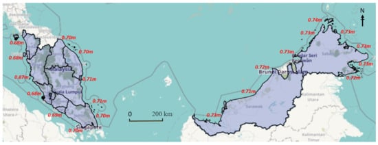
|
Methods |
Malaysia (Year) |
Global |
|---|---|---|
|
Tide Gauge |
2.2–5.3 (1993–2015) |
3.2 (2.8–3.6) |
|
Satellite Altimetry |
2.8–4.4 (1993–2015) |
|
Projection/Location |
Sea Level Rise |
Note |
|---|---|---|
|
Projection 2100 (RCP 8.5) for Peninsular Malaysia |
0.67–0.71 m (10.5–10.9 mm/year) |
Maximum SLR—east coast of Johor, Pahang, Terengganu and Kelantan |
|
Projection 2100 (RCP 8.5) for East Malaysia |
0.71–0.74 m (10.9–11.1 mm/year) |
Maximum SLR–Sabah (Kudat) |
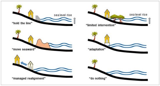
5. Shoreline Erosion Defense and Sea Level Rise Adaptation
|
Coastal Defense Approach |
Erosion Control (Future) |
Sea Level Rise Adaptation |
|---|---|---|
|
Coastal bunds, seawall, and revetment |
Effective |
Adaptive |
|
Offshore breakwater and geotextile tubes |
No significant change Long term: less effective |
No significant change Long term; less effective |
|
Submerged breakwater |
Less effective |
Not effective |
|
Beach nourishment |
Effective |
Effective, immediate impact |
|
Mangrove replanting |
Fairly effective |
Effective, the long term impact |
|
Tidal barrier, flood gate |
Not effective |
Avoid saline intrusion |
|
Abandoned wetland |
Effective |
Effective, need more space |
|
Innovation structure |
Effective and adaptive |
Adaptive |
References
- Chen, S.-L.; Jeevan, J.; Cahoon, S. Malaysian Container Seaport-Hinterland Connectivity: Status, Challenges and Strategies. Asia J. Shipp. Logist 2016, 32, 127–138.
- Flewwelling, P.; Hosch, G. Country Review—Malaysia; Food and Agriculture Organization of the United Unions: Rome, Italy, 2004; Available online: (accessed on 22 June 2021).
- Wong, P.P. Where have all the beaches gone. Singap. J. Trop. Geogr. 2003, 24, 111–132.
- Prasad, D.H.; Kumar, N.D. Coastal Erosion Studies—A Review. Int. J. Geosci. 2014, 5, 341–345.
- Noujas, V.; Thomas, K.V. Erosion Hotspots along Southwest Coast of India. Aquat. Procedia 2015, 4, 548–555.
- Yincan, Y. Coastal Erosion. In Marine Geo-Hazards in China; Elsevier: Amsterdam, The Netherlands, 2017; pp. 269–296.
- Amara, R.; Diop, M.; Diop, C.; Ouddane, B. Chapter 37: The Senegalese Coastal and Marine Environment. In World Seas: An Environmental Evaluation; Elsevier: Amsterdam, The Netherlands, 2019; pp. 855–873.
- Ariffin, E.H. Effect of Monsoons on Beach Morphodynamics in the East Coast of Peninsular Malaysia. Universite Bretagne Loire, France. 2017. Available online: (accessed on 12 February 2021).
- Church, J.A.; Aarup, T.; Woodworth, P.L.; Wilson, W.S.; Nicholls, R.J.; Rayner, R.; Lambeck, K.; Mitchum, G.T.; Steffen, K.; Cazenave, A.; et al. Chapter 13 Synthesis and Outlook for the Future. In Understanding Sea-Level Rise and Variability; Blackwell Publishing Ltd.: Amsterdam, The Netherlands, 2010.
- Hsan, S.; Begum, R.A.; Nor, N.G.; Abdul Maulud, K.N. Current and potential impacts of sea level rise in Malaysia. In Proceedings of the 3rd International Conference on Science & Technology Applications in Climate Change (STACLIM 2018), Melaka, Malaysia, 13–15 November 2018.
- De Almeida, B.A.; Mostafavi, A. Resilience of Infrastructure Systems to Sea-Level Rise in Coastal Areas: Impacts, Adaptation Measures, and Implementation Challenges. Sustainability 2016, 8, 1115.
- Zhang, K.; Douglas, B.C.; Leatherman, S.P. Global Warming and Coastal Erosion. Clim. Chang. 2004, 64, 41–58.
- Ghazali, N.H.M.; Awang, N.A.; Mahmud, M.; Mokhtar, A. Impact of Sea Level Rise and Tsunami on Coastal Areas of North-West Peninsular Malaysia. Irrig. Drain. 2018, 67, 119–129.
- JPBD. Report Rancangan Fizikal Zon Pesisiran Pantai Negara; Federal Town and Country Planning Department: Kuala Lumpur, Malaysia, 2012; ISBN 9789832839354.
- Nordin, D.Y.B. Towards sustainable coastal planning and policies from a Malaysian perspective. In Environmental Problems in Coastal Regions VI; WIT Press: Southampton, UK, 2006; pp. 45–54.
- Mohamad, M.F.; Lee, L.H.; Samion, M.K.H. Coastal Vulnerability Assessment towards Sustainable Management of Peninsular Malaysia Coastline. J. Environ. 2014, 5, 533–538.
- Nicholls, R.J.; Cazenave, A. Sea-level rise and its impact on coastal zones. Science 2010, 328, 1517–1520.
- NOAA. Hurricane Post Tropical Cyclone Sandy; National Oceanic and Atmospheric Administration & National Weather Service: Washington, DC, USA, 2012. Available online: (accessed on 22 January 2021).
- Hosen, N.; Nakamura, H.; Hamzah, A. Adaptation to Climate Change: Does Traditional Ecological Knowledge Hold the Key? Sustainability 2020, 12, 676.
- Hamzah, F.M.; Saimi, F.M.; Jaafar, O. Identifying the Monotonic Trend in Climate Change Parameter in Kluang and Senai, Johor, Malaysia. Sains Malays. 2017, 46, 1735–1741.
- Intergovernmental Panel on Climate Change; Coastal Zone Management Subgroup; Dronkers, J.J.; Misdorp, R.; Spradley, J.R. Strategies for Adaptation to Sea Level Rise; Ministry of Transport and Public Works, Rijkswaterstaat, Tidal Waters Division: Geneva, Switzerland, 1990.
- Stelljes, N.; Martinez, G.; McGlade, K. Introduction to the RISC-KIT web based management guide for DRR in European coastal zones. Coast. Eng. 2018, 134, 73–80.
- Frohle, P.; Müncheberg, R. Fokusthema 1: Küstenschutz. In RADOST Jahresbericht. RADOST-Berichtsreihe; RADOST-Verbund, Ed.; Bericht Nr. 21: Berlin, Germany, 2013.
- Gracia, A.; Rangel-Buitrago, N.; Oakley, J.A.; Williams, A.T. Use of ecosystems in coastal erosion management. Ocean Coast. Manag. 2018, 156, 277–289.
- Heurtefeux, H.; Sauboua, P.; Lanzellotti, P.; Bichot, A. Coastal Risk Management Modes: The Managed Realignment as a Risk Conception More Integrated. In Risk Management in Environment, Production and Economy; Intech Open: London, UK, 2011.
- Sarkar, M.S.K.; Begum, R.; Pereira, J.; Jaafar, A.; Saari, M.Y. Impacts of and Adaptations to Sea Level Rise in Malaysia. Asian J. Water Environ. Pollut. 2014, 11, 29–36. Available online: (accessed on 12 December 2020).
- Williams, A.T.; Rangel-Buitrago, N.; Pranzini, E.; Anfuso, G. The management of coastal erosion. Ocean Coast Manag. 2018, 156, 4–20.
- DID. National Coastal Erosion Study (NCES2015) Report; Department of Drainage and Irrigation: Kuala Lumpur, Malaysia, 2015; p. ES27.
- EPU. National Coastal Erosion Study (NCES1985) Report; Economy Planning Unit, Department of Drainage and Irrigation, Prime Minister Office: Kuala Lumpur, Malaysia, 1985.
- NAHRIM. The Study of Impact of Climate Change on Sea Level Rise in Malaysia; National Hydraulic Research Institute of Malaysia: Selangor, Malaysia; Ministry of Natural Resources and Environment: Selangor, Malaysia, 2010.
- NAHRIM. Impact of Climate Change: Sea Level Rise Projection in Malaysia; National Hydraulic Research Institute of Malaysia: Selangor, Malaysia; Ministry of Water, Land and Natural Resources: Putrajaya, Malaysia, 2017.
- Church, J.A.; Clark, P.U.; Cazenave, A.; Gregory, J.M.; Jevrejeva, S.; Levermann, A.; Merrifield, M.A.; Milne, G.A.; Nerem, R.S.; Nunn, P.D. Sea-Level Rise by 2100. Science 2013, 342, 1445.
- Hamid, A.I.A.; Din, A.H.M.; Hwang, C.; Khalid, N.F.; Tugi, A.; Omar, K.M. Contemporary sea level rise rates around Malaysia: Altimeter data optimization for assessing coastal impact. J. Asian Earth Sci 2018, 166, 247–259.
- Awang, N.A.; Hamid, M.R.A. Sea Level Rise in Malaysia. Hydrolink 2013, 2, 47–49. Available online: (accessed on 22 June 2021).
- Ghazali, N.H.M. Coastal erosion and reclamation in Malaysia. Aquat. Ecosyst. Health Manag. 2006, 9, 237–247.
- Cheon, S.-H.; Suh, K.-D. Effect of sea level rise on nearshore significant waves and coastal structures. Ocean Eng. 2016, 114, 280–289.
- Le Cozannet, G.; Garcin, M.; Petitjean, L.; Cazenave, A.; Becker, M.; Meyssignac, B.; Walker, P.; Devilliers, C.; Le Brun, O.; Lecacheux, S.; et al. Exploring the relation between sea level rise and shoreline erosion using sea level reconstructions: An example in French Polynesia. J. Coast. Res. 2013, 165, 2137–2142.
- Ishak, D.S.M.; Abd Wahab, A.K.; Teh, S.Y.; Jamal, M.H. Projected ecosystem response to the anticipated effects of sea level rise. Phys. Chem. Earth 2020, 120, 102934.
- Lavine, W.; Jamal, M.H.; Abd Wahab, A.K.; Kasiman, E.H. Effect of sea level rise on oil spill model drift using TELEMAC-2D. J. Water Clim. Chang. 2020, 11, 1021–1031.
- Awang, N.A.; Anuar, N.; Hamid, M.R.A.; Mohamad, M. Modification of design parameters for coastal protection structures in view of future sea level rise for east coast Peninsular Malaysia. In Proceedings of the Australian Coasts & Ports Conference, Hobart, Tasmania, 10–13 September 2019.
- Jones, A. Chapter 7: Potential Coastal Erosion of the Swan Coastal Plain due to long-term Sea Level Rise. In Natural Hazard Risk in Perth, WA; Geoscience Australia: Canberra, Australia, 2005.
- Romine, B.M.; Fletcher, C.H.; Barbee, M.M.; Anderson, T.R.; Frazer, L.N. Are beach erosion rates and sea-level rise related in Hawaii? Glob. Planet Chang. 2013, 108, 149–157.
- Ling, S.Y.; Veerasamy, K.; Jamal, M.H.; Ab Razak, M.S. Preliminary Modelling Assessment of Hydrodynamic Simulation due to Terengganu Airport Runway Extension. In IOP Conference Series: Earth and Environmental Scienc; IOP Publishing: Bristol, UK, 2019; Volume 357, p. 012036.
- Rangel-Buitrago, N.; Williams, A.; Anfuso, G. Hard protection structures as a principal coastal erosion management strategy along the Caribbean coast of Colombia. A chronicle of pitfalls. Ocean Coast. Manag. 2018, 156, 58.

