The shoreline of Malaysia is exposed to threats of coastal erosion and a rise of sea level. The National Coastal Erosion Study, 2015 reported that 15% of an 8840 km shoreline is currently eroding, where one-third of those falls under the critical and significant categories that require structural protection. The Study of Sea Level Rise in Malaysia, 2017 presented a sea-level increase of 0.67–0.74 mm on average yearly.
1. Introduction
As a maritime nation, Malaysia’s shoreline is consistently exposed to threats from the ocean, resulting in coastal erosion and sea-level rise. The country is located near the equator in Southeast Asia where its major ports are situated within international maritime and shipping routes
[1]. It is surrounded by seven sea areas where the total sea area is almost twice the land area
[2]. Hence these two distinctive threats had continuously causing adverse impacts on physical, socioeconomy, and biodiversity along the coast
[3].
Beach erosion is defined as long-term sediment loss within coastal zones due to changes in a hydrodynamic pattern such as wind, wave, and current
[4][5][4,5]. In the natural coastal cycle, sediments are transported and distributed by these hydrodynamic forces along the coast, providing material for dunes, beaches, and marshes
[6]. Even though anthropogenic activities mostly drive erosion, however, with a combination of natural forces; the impacts are exacerbated by climate change
[7]. In Malaysia, the coastal processes are greatly influenced by the East Asian monsoon system that brings a great intensity of the related physical phenomena associated with waves, current velocities, winds, and a high rainfall frequency
[8], subsequently impacting the cycle of beach erosion and accretion.
Whereas sea level rise (SLR) is a permanent coastal inundation due to the increasing global mean sea level, as a result of climate change impact
[9]. Major contributors to SLR are ocean thermal expansion, melting of ice sheets and glaciers, and changes in terrestrial waters
[10]. SLR can be considered one of the most significant and costly effects of global warming. Potential adverse impacts of SLR are coastal flooding, accelerated coastal erosion, saltwater intrusion, and land subsidence
[11]. Globally sea level rise is also found ultimately responsible for long-term coastal erosion problems
[12].
The impacts of coastal erosion and sea-level rise include loss of lives, disruption to economic sectors, and degradation of natural ecosystems and biodiversity
[13]. Environmental problems were continuously affecting over 30% of the Malaysian coastal population
[14] and escalated due to climate change and anthropogenic effects. More than 20% of Malaysia’s coastal zones have been developed mainly for urbanization and tourism purposes
[15], as it is also the centre of economic activities comprising aquaculture, agriculture, industries, and oil and gas exploitation
[16][17][16,17]. These threats severely affect the coastal areas due to land encroachment and inundation, especially with regards to the ageing of coastal structures due to chronic and acute weather exposure hence accelerating infrastructure degradation and projected increased population residing in coastal urban areas
[18][19][20][18,19,20].
2. Coastal Management Strategies
The earliest study by the Intergovernmental Panel on Climate Change (IPCC): Coastal Management Subgroup and Response Strategies Working Group proposed three approaches for adaptation to sea-level rise, namely protection, retreat, and accommodation
[21][62]. Discussions on available methods evolved and based on a recent management guide for disaster risk reduction in the European coastal zone, five different strategies are adopted
[22][23][63,64]. In terms of coastal risk management in Malaysia, these options can be suited for both coastal erosion defense and sea-level rise adaptation.
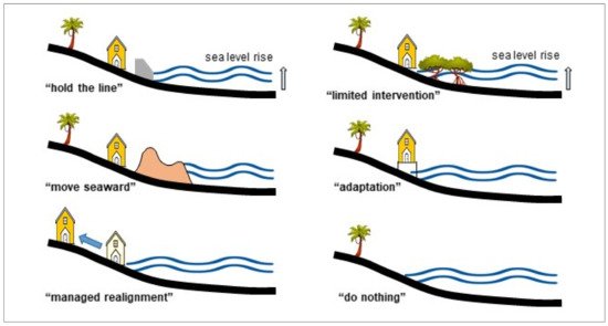
Figure 1 proposes six management strategies, which were also adopted from various studies by
[24][25][26][65,66,67].
Figure 1. Classification of adopted coastal management strategies as modified from
[22][63].
“Move seaward” is only carried out if coastal land reclamation is critically required, as the strategy leads to various adverse impacts on the environment. Adjacent ecosystems, wetlands, salt marshes, and mangroves are becoming more vulnerable due to coastal squeeze effects. “Hold the line strategy” maintains the existing shoreline due to significant land use, infrastructures, and socioeconomic activities within the coastal zone.
“Managed realignment” involves the relocation of critical structures or land use to further inland. The first two strategies are generally costly due to the construction of hard structures, such as seawall, revetment, breakwater, and a combination of soft engineering beach nourishment techniques. Whereas, the major cost in “managed realignment” consists of land purchase, rebuilding infrastructure, and relocation of existing businesses.
“Limited intervention” requires low or potentially no cost, such as changing existing land use, restoration of wetland, and mangrove replanting. The “Adaptation or accommodate’ strategy is the continuous usage of land at risk with no attempt to prevent the land from damage such as raising the platform level and elevated buildings. “Do nothing” is no active intervention, vacant land, or available wetland that has insignificant physical and economic impacts that are selected as sacrificial areas for inundation or erosion downdrift impact areas. Coastal defense strategy for protection from threats of erosion and sea-level rise is simplified in
Table 1.
Table 1. General comparison of coastal structures modified from
[27][21]. ‘Reproduced with permission from The manage-ment of coastal erosion
[27][21], 2018; published by Elsevier, License Number 5071160448480, Date 17 May 2021’.
|
| Coastal Protection System |
|
| Pros |
|
| Cons |
|
|
| Hard Structures |
| Seawalls, revetments, armor rocks |
| Breakwater and perpendicular groyne |
| Detached and offshore breakwater |
| Submerged dykes and breakwater |
| Temporary sandbag and tubes |
| Floodgate and tidal barriers |
| Innovative structures |
|
| Effective shoreline control |
| Quick/different types |
| Promote beach build-up |
| Safe for public use |
| Promote beach build-up |
| Aesthetic value, reef/coral |
| Cheap and quick |
| Avoid saline intrusion |
| Easy, quick, and cheap |
|
| Wave overtop/reflection |
| Local scour and erosion |
| Erosion at downdrift |
| Rip current generation |
| Costly, eye-sore |
| Less effective |
| Require maintenance |
| Deplete sediment source |
| Less effective |
|
|
| Soft Engineering and Ecological Based |
| Beach nourishment |
|
|
|
Total |
|
|
|
|
8840.0 |
|
|
|
|
1347.6 |
|
|
|
| 431.3 |
|
Moreover, NCES 2015 also recommended a two-pronged approach: curative action and a preventative strategy. The first approach refers to the immediate coastal protection works along with the critically eroding coastal sites. The latter focuses on administrative instruments and development control plans to pre-empt potential erosion problems due to coastal development. Some case studies on available coastal protection structures as curative methods at selected eroded sites are briefly discussed.
4. Sea Level Rise
The first sea-level rise (SLR) study in Malaysia by NAHRIM collaborated with the California Hydrologic Research Laboratory (CHRL), the United States of America in 2010. The methodology in obtaining SLR rates was based on the atmosphere–ocean global climate model concerning Assessment Report No. 4, Intergovernmental Panel on Climate Change 2007 (AR4 IPCC) by using the linear trend analysis on the tide gauge and satellite altimeter
[30][132]. The study showed that the national SLR projection was 2.5–10.6 mm/year, slightly higher than the global projection, with a maximum rate projected for Kedah, Kelantan, and Sabah.
An updated national sea-level rise study due to climate change impact was conducted by NAHRIM recently in 2017 with the collaboration of the Commonwealth Scientific and Industrial Research Organisation, Australia (CSIRO), and Universiti Kebangsaan Malaysia (UKM)
[31][133]. The study was based on AR5 IPCC 2013 on various RCP (representative carbon pathway) scenarios by using the latest tide gauge data and satellite altimeter. The projections were derived from Coupled Model Inter-comparison Project Phase 5 (CMIP5) with the combination of data from global ocean thermal expansion, mass loss due to glaciers, the surface mass balance of ice sheets, land water storage change, and GIA-induced regional sea-level changes in surface loading over the previous glacial cycle
[32][134]. Regarding the updated study
[31][133], the rate of sea-level increase and projection details in the year 2100 are given in
Table 3 and
Table 4, respectively.
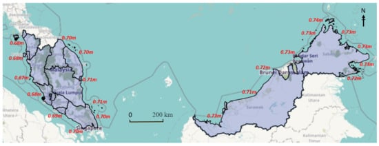
Figure 219 presents the map of SLR projection along the shoreline in Malaysia based on a similar RCP 8.5 scenario. A study using the radar altimeter database system (RADS) also suggested that land subsidence due to excessive water extraction also enhanced the impacts of sea-level rise on coastal cities
[33][135].
Figure 219. Map of the sea-level rise projection of Malaysia in 2100 based on RCP 8.5
[31][133]. Reproduced from Report on Impact of Climate Change: Sea Level Rise Projection in Malaysia, 2017; published by National Water Research Institute of Malaysia.
Table 3. Historical average rate of sea level (mm/year) based on IPCC AR5
[31][133]. Reproduced from Report on Impact of Climate Change: Sea Level Rise Projection in Malaysia, 2017; published by National Water Research Institute of Malaysia.
|
| Methods |
|
Coastal Defense Approach |
| Malaysia (Year) |
|
| Global |
|
|
| Tide Gauge |
|
| 2.2–5.3 (1993–2015) |
|
| 3.2 (2.8–3.6) |
|
|
| Satellite Altimetry |
|
| 2.8–4.4 (1993–2015) |
|
Table 4. Projection of sea-level rise in Malaysia for * RCP 8.5 in year 2100
[31][133]. Reproduced from Report on Impact of Climate Change: Sea Level Rise Projection in Malaysia, 2017; published by National Water Research Institute of Malaysia.
|
| Projection/Location |
|
| Sea Level Rise |
|
| Note |
|
Erosion Control (Future) |
|
| Sea Level Rise Adaptation |
|
|---|
|
| Projection 2100 (RCP 8.5) |
| for Peninsular Malaysia |
|
| 0.67–0.71 m |
| (10.5–10.9 mm/year) |
|
| Maximum SLR—east coast of Johor, Pahang, Terengganu and Kelantan |
|
|
|
|
| Coastal bunds, seawall, and revetment |
|
| Effective |
|
| Adaptive |
|
Mangrove replanting |
| The artificial reef, seagrass, and seaweed |
| Creation of wetland and dune building |
|
Projection 2100 (RCP 8.5) |
| for East Malaysia |
| As the natural sandy beach |
| As natural muddy shore |
|
| 0.71–0.74 m Rejuvenate biodiversity |
| (10.9–11.1 mm/year) Create a new ecosystem |
|
| Expensive, maintenance |
| Long term effect |
| Long term effect |
|
| Maximum SLR–Sabah (Kudat) Long term effect |
|
|
|
| Infrastructure Modification |
| Elevation of seawall and breakwater |
| Raise the level of platform and piers |
|
| Cheaper and adaptive |
| Periodically if required |
|
| Eyesore, limited beach space, maintenance |
|
The selection of the coastal protection system is site-specific. For shoreline control, hard structures such as seawalls and revetment are the most effective, fast, and easy. Perpendicular structures such as groynes and breakwater promote natural sediment deposition and beach build-up. However, downdrift erosion is expected. Soft engineering techniques are ecologically friendly but are costly and require a longer time for significant impacts.
3. Coastal Erosion
The National Coastal Erosion Study in 2015 showed that 1348 km from a total of 8840 km or 15% of the shoreline is currently facing erosion problems under three categorizations: critical, significant, and acceptable erosions
[28][68]. In this study, the demarcation of the coastline is between 0.2 and 1 km upstream of river mouths. For the past 30 years, protection works and shoreline management plans have been implemented; hence, the impacts of erosion are controlled even though they still occur primarily during the monsoon seasons. As compared to the earliest study, the National Coastal Erosion Study 1985 stated that 29% of 4809 km (not including islands) coastline was eroded under similar categories
[29][69]. In the updated NCES 2015, improvements were made towards the descriptions, methods, and techniques in classifying erosion categories, with inclusions of scoring for physical and economic scores. In addition, recommendations on coastal management and mitigation measures were also included.
Based on the NCES 2015, Category 1 or critical erosion is a fast retreating coastline at the rate of more than 4 m/year with generally dense human settlement, some commercial/industrial activities being served by significant public infrastructure and facilities. Significantly eroded or Category 2 is the retreating shoreline at the rate of more than 1 m/year but less than 4 m/year. The area is generally sparsely populated or some agricultural activities are being served by relatively minor public infrastructure and facilities. Whereas, Category 3 is considered acceptable erosion; a slowly retreating coastline of less than 1 m/year with generally no human settlement and minimal agricultural activities not served by public infrastructure and facilities.
Information on eroded sites along the shoreline of Malaysia under the different categorizations is presented in
Table 2. Statistically, out of the total eroded length, critical erosion was 4%, followed by significant erosion at 28% and the remaining 68% was acceptable erosion. The aggregate length of erosion under Category 1 and Category 2 was approximately one-third of the total eroded shoreline at 431.3 km. Typical mitigation measures for Category 1 and Category 2 erosions consist of hard structure construction such as revetment, breakwater, seawalls, and similar defense structures that are carried out quickly to avoid disastrous consequences. The proposed mitigation measures of the identified site should be technically feasible, economically viable, environmentally friendly, and socially acceptable.
Table 2. Coastline erosion condition in 2015 as reported by
[28][68]. ‘Reproduced from Report on National Coastal Erosion Study, 2015; published by Department of Irrigation and Drainage, Malaysia’.
|
| State |
|
| Length (km) |
|
| Total Eroded Coastline (km) |
|
| Critical and Significant Erosion (km) |
|
|
| Perlis |
|
| 26.4 |
|
| 0.1 |
|
| 0.0 |
|
|
| Kedah |
|
| 639.8 |
|
| 26.8 |
|
| 15.5 |
|
|
| Pulau Pinang |
|
| 215.6 |
|
| 16.3 |
|
| 9.7 |
|
* Global projection for AR5 RCP 8.5 in the year 2100 is 0.73 m (0.52–0.98 m) with a rate of 8–16 mm/year.
A detailed study on the impact of sea-level rise was carried out by using DTM, GIS, and MIKE21 numerical software tools, conducted at several coastal cities in Malaysia to produce inundation models and vulnerability maps
[34][136]. This section reviews the studies conducted from 2010 to 2018, where the previous AR4 IPCC was referred. The proposed adaptation measures to sea-level rise could also be a selection of hard structures or soft engineering approaches, incorporated with various approaches of the shoreline management strategy.
5. Shoreline Erosion Defense and Sea Level Rise Adaptation
The function of coastal protection structures is assessed from the perspective of shoreline erosion defense and sea-level rise adaptation. In most cases for Category 1 and Category 2 erosion, protection structures are constructed retrospectively at eroded sites after a series of erosion events
[35][145]. For Category 3, continuous monitoring is carried out to minimize the impact of physical and socioeconomic activities.
A study by
[36][146] stated that a higher sea-level rise leads to greater wave height towards the shore inside the surf zone due to less depth-limited breaking. The same trends were observed for relative changes in wave run-up height and crest freeboard. Therefore, a higher level of coastal defense structures is proposed for protection against sea-level rise and erosion related to higher waves due to increased water level. Disturbance in coastal hydrodynamics due to a sea-level rise leads to shoreline, morphological, and sedimentation concentration changes
[37][38][39][147,148,149]. For example, the structure crest level has to be raised by a magnitude larger than the corresponding mean sea-level rise
[40][150]. A study by
[41][151] stated that in some cases, the erosion rate due to sea-level rise is magnetized approximately 2.5 times higher for the next 100 years. However, it is important to note that coastal structures may have a localized impact on accretion or erosion changes, depending on shoreline trends, as suggested by many studies, including
[42][43][152,153].
Coastal hard structures are commonly used for the “hold the line” strategy at most of the eroded coasts where physical and economic activities are vital as such in Morib, Marang, and Tanjung Piai. Properly designed structures such as coastal bunds, seawall, and revetment are effective for protection. However, adverse physical and environmental impacts are expected at the adjacent shoreline and downdrift area
[44][154]. Nevertheless, the approach provides a specific solution to the eroded site promptly. The structures are also adaptive to sea-level rise as long as structural integrity and stability are not affected. The finish level of bunds, seawall, and revetment can be periodically increased when required to avoid overtopping and inundation along the protected shore. This “adaptation” option is generally practical for cost-saving and immediate solutions. Offshore breakwater and geotextile tubes are located within the intertidal zone with minimum design crest height. Therefore, no significant change is expected in terms of function effectiveness for erosion control and short-medium sea-level rise adaptation. However, underwater structures such as submerged breakwater WABCORE in Marang and dykes in Kemaman are expected to be less effective due to sea-level rise, as the freeboard level is increased. However, their ecologically based function as a coral and fish ecosystem restorer is expected to be improved.
Beach nourishment “hold the line” is commonly used at sandy beaches with major tourism activities such as in Port Dickson and Kuala Terengganu. The system requires periodical maintenance of sediment supply to make sure its effectiveness as a soft engineering approach in erosion control. In terms of sea-level rise adaptation, a long-term continuous supply of sediment is required. Mangrove replanting is one of the strategies in ‘limited intervention’, both as erosion and sea-level rise control measures. The approach is considered fairly effective as a long-term solution, as the ecosystem is crucial to the coastal environment. However, as the sea-level keeps increasing, suitable areas for mangrove replanting are becoming limited due to backshore development and current land use. The abandoned coconut plantation in Batu Pahat is one of the examples of a sacrificial area for the “do nothing” strategy. As water volume is expected to increase, more vacant lands and wetlands are required to adapt to sea-level rise. “Managed realignments” strategy requires systematic evaluation and integrated management procedure as it involves various stakeholders. Some examples include the relocation of a coconut plantation in Batu Pahat, aquaculture ponds in Sabak Bernam, village houses at Marang, and coastal infrastructures in Kuala Terengganu further inland.
Coastal reclamation is an example of a “move seaward” strategy, which is only approved for critical development. Environmental impact assessment and detailed hydraulic study must be conducted to evaluate adverse environmental impacts and propose mitigation measures before execution. A combination of hard structure and soft engineering techniques is used along the reclaimed shoreline in most cases. A detailed study should be carried out for better projection by using detailed subsurface data and advanced numerical models that is site-specific. The summary of coastal structure functions as future beach erosion control and sea-level rise adaptation is proposed in
Table 5.
Table 5. Summary of coastal structures as erosion control and sea-level rise adaptation.
|
|
|
| Offshore breakwater and geotextile tubes |
|
| No significant change |
| Long term: less effective |
|
| No significant change |
| Long term; less effective |
|
|
| Submerged breakwater |
|
| Less effective |
|
| Not effective |
|
|
| Perak |
|
|
| Beach nourishment |
| 397.5 |
|
|
| Effective |
| 95.1 |
|
| Effective, immediate impact |
| 33.9 |
|
|
| Selangor |
|
| 492.1 |
|
| 74.6 |
|
| 23.4 |
|
|
| Negeri Sembilan |
|
| 65.0 |
|
| 9.8 |
|
| 9.6 |
|
|
| Mangrove replanting |
|
| Fairly effective |
|
| Effective, the long term impact |
|
|
| Tidal barrier, flood gate |
|
| Not effective |
|
| Avoid saline intrusion |
|
| Melaka |
|
| 120.5 |
|
|
|
| Abandoned wetland |
|
| Effective |
| 3.7 |
|
| Effective, need more space |
| 1.9 |
|
|
| Johor |
|
|
| Innovation structure |
|
| 813.6 |
|
| Effective and adaptive |
|
| 64.7 |
|
| 38.1 |
|
|
| Adaptive |
|
| Pahang |
|
| 378.4 |
|
| 61.8 |
|
| 18.4 |
|
|
| Terengganu |
|
| 443.1 |
|
| 48.7 |
|
| 27.7 |
|
|
| Kelantan |
|
| 179.5 |
|
| 19.8 |
|
| 4.5 |
|
|
| Sarawak |
|
| 1234.1 |
|
| 492.5 |
|
| 163.4 |
|
|
| Sabah |
|
| 3752.9 |
|
| 429.3 |
|
| 82.1 |
|
|
| Labuan |
|
| 81.5 |
|
| 4.4 |
|
| 3.1 |
|