- Subjects: Remote Sensing
- |
- Contributors:
- Sergio Vélez ,
- Sergio Vélez ,
- Rubén Vacas ,
- Hugo Martín ,
- David Ruano-Rosa ,
- Sara Álvarez


- leaf area
- drone
- pistachio
- aerial
- image analysis
- precision agriculture
- machine learning
- spatial variability
- random forest
This video is adapted from 10.3390/rs14236006
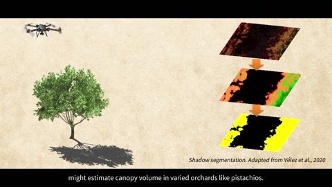
Interest in pistachios has increased in recent years due to their healthy nutritional profile and high profitability. In pistachio trees, as in other woody crops, the volume of the canopy is a key factor that affects the pistachio crop load, water requirements, and quality [1]. However, canopy/crown monitoring is time-consuming and labor-intensive, as it is traditionally carried out by measuring tree dimensions in the field. Therefore, methods for rapid tree canopy characterization are needed to provide accurate information that can be used for management decisions. Remote Sensing and UAVs could aid in these operations since they have shown potential in the field of precision agriculture for Site-Specific Management [2] or disease assessment [3]. The present study focuses on developing a new, fast, and low-cost technique, based on two main steps, for estimating the canopy volume in pistachio trees. The first step is based on adequately planning the UAV (unmanned aerial vehicle) flight according to light conditions and segmenting the RGB (Red, Green, Blue) imagery using machine learning methods. The second step is based on measuring vegetation planar area and ground shadows [4] using two methodological approaches: a pixel-based classification approach and an OBIA (object-based image analysis) approach. The results show statistically significant linear relationships (p < 0.05) between the ground-truth data and the estimated volume of pistachio tree crowns, with R2 > 0.8 (pixel-based classification) and R2 > 0.9 (OBIA). The proposed methodologies show potential benefits for accurately monitoring the vegetation of the trees. Moreover, the method is compatible with other remote sensing techniques, usually performed at solar noon, so UAV operators can plan a flexible working day [5]. Further research is needed to verify whether these results can be extrapolated to other woody crops.
- Raquel Martínez-Peña; Sergio Vélez; Rubén Vacas; Hugo Martín; Sara Álvarez; Remote Sensing for Sustainable Pistachio Cultivation and Improved Quality Traits Evaluation through Thermal and Non-Thermal UAV Vegetation Indices. Appl. Sci. 2023, 13, 7716, .
- Sergio Vélez; Florian Rançon; Enrique Barajas; Guilhem Brunel; José Antonio Rubio; Bruno Tisseyre; Potential of functional analysis applied to Sentinel-2 time-series to assess relevant agronomic parameters at the within-field level in viticulture. Comput. Electron. Agric. 2022, 194, 106726, .
- Sergio Vélez; Mar Ariza-Sentís; João Valente; Mapping the spatial variability of Botrytis bunch rot risk in vineyards using UAV multispectral imagery. Eur. J. Agron. 2023, 142, 126691, .
- Sergio Vélez; Carlos Poblete-Echeverría; José Antonio Rubio; Rubén Vacas; Enrique Barajas; Estimation of Leaf Area Index in vineyards by analysing projected shadows using UAV imagery. OENO One 2021, 55, 159-180, .
- Sergio Vélez; Rubén Vacas; Hugo Martín; David Ruano-Rosa; Sara Álvarez; A Novel Technique Using Planar Area and Ground Shadows Calculated from UAV RGB Imagery to Estimate Pistachio Tree (Pistacia vera L.) Canopy Volume. Remote. Sens. 2022, 14, 6006, .