 +1 credit
Video Upload Options
The Yangtze River Valley is an important economic region and one of the cradles of human civilization. It is also the site of frequent floods, droughts, and other natural disasters. Conducting Holocene environmental archaeology research in this region is of great importance when studying the evolution of the relationship between humans and the environment and the interactive effects humans had on the environment from 10.0 to 3.0 ka BP, for which no written records exist.
1. Introduction
Environmental archaeology is an interdisciplinary science combining archaeolog-ical science, geochronology, Quaternary geology, zoology, botany, sedimentology, stra-tigraphy, geochemistry, micropaleontology, remote sensing, GIS, and other natural sciences [1][2][3][4][5][6][7][8][9]. Primarily through the analysis and research of sediments from archae-ological site stratigraphy and the natural stratigraphic profile, environmental archae-ology reveals environmental processes occurring since the dawn of humanity, particu-larly human-related environmental issues during the Holocene [10][11][12][13][14][15][16][17][18][19][20][21]. The goal of environmental archaeology is to understand how the natural environment impacted the survival of ancient humans and how ancient humans lived and developed through their simultaneous adaptation to and influence on the environment [21][22][23][24][25][26]. Environ-mental archaeology focuses on the environmental evolution and human–landscape in-teractions closely related to the development of human civilization [4][27][28][29].
Environmental archaeology took root in the 1920s in China. In 1921, Swedish scholar Andersen [30] studied the physiognomy, climate, and other natural features during an archaeological excavation in Yangshao Village, Mianchi County, Henan Province. In the 1950s, natural science methods, such as palynology, age determina-tion, analysis of animal and plant relics, sediment analysis, and other techniques, gradually began to be applied to archaeology. In this context, archaeologists began to focus on cooperating with experts in such disciplines as geology, geography, biology, and environmental science to carry out research on the relationship between ancient cultures and the paleoenvironment, thus promoting the development of environmen-tal archaeology in China. In the 1960s, more scholars began scrutinizing the environ-mental background of cultural sites. For example, Pei [31] used zoolites to study the habitation environments of ancient humans. Zhou [32] conducted a sporopollen analy-sis and paleoclimate environmental research on the Banpo Site. In the 1970s, Chu [33] analyzed the paleoenvironment and paleoclimate in China over the past 5000 years through archaeology and research into fauna and flora data, along with ancient litera-ture. In the 1980s, the influence of many European and American environmental ar-chaeological theories and methods gradually increased in China, accelerating the pro-gress of environmental archaeology. Botanists specializing in sporopollen have focused on the environmental background of ancient sites; many scholars in geography, zool-ogy, and other disciplines are also gradually becoming involved in environmental ar-chaeological research and have achieved fruitful results in their respective fields of study [34][35].
The first session of the Academic Seminar of Environmental Archaeology in Chi-na was held in Lintong, Xi’an, Shaanxi Province in October 1990 [36]. The conference successfully facilitated the discussion and exchange of academic achievements in en-vironmental archaeology, making it the first milestone in the development of envi-ronmental archaeology in China. This indicated the formal establishment of a new branch of archaeology—environmental archaeology—in China. It also heralded the ar-rival of a great new period of development for environmental archaeology in China. Since then the second, third, fourth, fifth, and sixth sessions of Academic Seminar of Environmental Archaeology in China were, respectively, held in Luoyang, Henan Province in September 1994; Jinan, Shandong Province in September 2002; Pujiang, Zhejiang Province in November 2006; Lanzhou, Gansu Province in September 2012; and Guangzhou, Guangdong Province in November 2016. These sessions systemati-cally summarized the development of national environmental archaeology at different stages [5][37][38][39]. At the Fourth Session of Academic Seminar of Environmental Ar-chaeology in China, Zhou [40] defined the fundamental task of environmental archae-ology in China: to interpret the characteristics of Chinese culture from the characteris-tics of the Chinese environment. This mission has guided the development of envi-ronmental archaeology in China [4]. Since then, the environmental archaeology of China has entered a new stage of vigorous development.
Based on the academic research conditions that have existed for many years, en-vironmental archaeology research has mainly included three aspects [5][35][41][42][43][44]: (1) research on the evolutionary rules of spatiotemporal distribution for human sites in the research area; (2) research on the archaeological stratigraphy of typical sites in the research area; and (3) research on environmental evolution based on the typical natural sediments in the research area. Among these, the first type of research helps increase understanding of the process of human civilization from birth to development (that is, the source and flow of archaeological culture), and the relationships between changes in the spatiotemporal distribution of human sites and geography, physiognomy, ter-rain, and other natural geographical elements and social changes. The second kind of research helps reveal the human–landscape interactions in different periods of the re-search area from the perspective of vertical stratigraphy and spatiotemporal change. The third kind of research is an extension or supplement to the second kind. Stratig-raphy of a human site, during the process of formation, would inevitably be disturbed by human actions, resulting in the loss of strata in some eras. Therefore, the integrated comparative study of archaeological strata and typical continuous records of environ-mental evolution in the research area can reveal the relationship between ancient hu-man activities and the paleoenvironment in the area. In addition, the international en-vironmental archaeology field now pays particular attention to the impacts of climate change—particularly abrupt climate change—on human activities, cultural develop-ment, and civilization processes [19][45][46][47][48][49]. However, some issues about mismatches of scale in the application of paleoclimatic research to environmental archaeology have been focused by some scholars [50][51]. We can not fall into environmental determin-ism. Even as many recent studies would like to advance the connection between cli-matic events and social response, the nature of the data, including their resolutions and quantities, must be improved if we are to assess them. Understanding proper ways with which to incorporate paleoclimatic, archaeological, and historical data in reconstructions of the past must be a focus of future environmental archaeology work.
Located in the southeastern portion of the Asian continent (Figure 1, located at the position of 24°27′–35°54′ N and 90°13′–122°19′ E), the Yangtze River Valley is signifi-cantly affected by the intensity variations of monsoon rainfall, which had an impact on the rise and fall of early Chinese civilizations [43][52][53]. The Yangtze River is also the physical and cultural line dividing North and South China (Figure 1), flows through a wide variety of ecosystems, and is the habitat of several endemic and endangered spe-cies [54][55]. Meanwhile, a large number of Neolithic archaeological sites in the region provide excellent material for the high-resolution study of human–landscape interac-tions [43]. However, despite its importance in the understanding of large-scale region-al Holocene environmental change and cultural evolution (Figure 2), studies on the progress of environmental archaeology research in the Yangtze River Valley, where the history of Neolithic and Bronze Age cultures spans nearly 7000 years (Figure 2), and analyses of human–environment interaction in prehistory, have not been thoroughly reviewed. This manuscript synthesizes a large body of recently published materials regarding Holocene environmental archaeology throughout the catchment of the Yangtze River, to provide comprehensive insight into Holocene environmental and cultural interaction in this region.
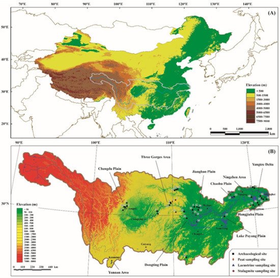
Figure 1. (A) Location of the Yangtze River Valley in China, the topographic map is based on a 30 m Digital Elevation Model (DEM). (B) Geomorphic features and main Neolithic cultural areas of the Yangtze River Valley, showing the locations of sites mentioned in the text and the distribution of large freshwater lakes; 1: Dajiuhu; 2: Shanbao Cave; 3: Zhongba; 4: Yuxi; 5: Zhangjiawan; 6: Shuangyantang; 7: Guiyuanqiao; 8: Baodun; 9: Sanxingdui; 10: Jinsha; 11: Shi-erqiao; 12: JZ-2010 section; 13: Zhoulao core; 14: Lake Dongting core; 15: Heshang Cave; 16: Yuchanyan; 17: Xianrendong; 18: Chengbeixi; 19: Daxi; 20: Qujialing; 21: Shijiahe; 22: Chengtoushan; 23: Zhongqiao; 24: Tanjialing; 25: Sanfangwan; 26: Liaowadian; 27: Lijiazui; 28: Tuojiazhou; 29: Lake Chaohu core; 30: Qianmutian; 31: Linfengqiao; 32: Tangzui; 33: Majiabang; 34: Songze; 35: Liangzhu; 36: Maqiao; 37: Caoxieshan; 38: Chuodun; 39: Guangfulin; 40: Luotuodun; 41: Qingdun; 42: Taozhuang.
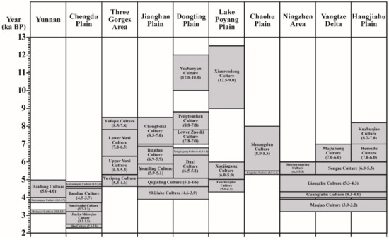
Figure 2. Main Neolithic and Bronze cultures of ten areas of the Yangtze River Valley.
2. Overview of Holocene Environmental Archaeology Research in the Yangtze River Valley
In the upper reaches of the Yangtze River, the main stream and tributaries have large head drops, many supercritical flows, and shoals. With the exception of the Chengdu Plain in the Sichuan Basin, the upper reaches of the Yangtze River are less hospitable for human habitation than the middle and lower reaches [56][57]. However, in the middle reaches of the Yangtze River, there are many plains and lakes conducive to human farming and civilization development. The earliest Neolithic sites and rice remains in the Yangtze River Valley appeared in this area, including the Yuchanyan Site in Daoxian County, Hunan Province and the Xianrendong Cultural Sites in Wann-ian County, Jiangxi Province [43]. Although there are vast plains in the lower reaches of the Yangtze River, floods, transgressions, storm surges, and other natural disasters have a great impact [58]. Therefore, recent Holocene environmental archaeology re-search has generally been based on clues from event stratigraphy for paleofloods and sea-level changes in the Yangtze River Valley [17][35][59][60][61][62][63][64][65][66][67][68]. For example, there are paleofloods recorded at the Zhongqiao Neolithic site in the Jianghan Plain and in the Hanjiang River Valley in the Yangtze River [63][69]. Furthermore, due to the high sea level in Holocene, human cultural relics of the early Neolithic are difficult to be found in the archeological strata with an age of 7.8 ka BP or earlier and with an elevation of lower than 1.08 m on the Huanghai Vertical Datum [60]. From the perspective of the spatiotemporal distribution of archaeological sites, archaeological stratigraphy of typi-cal sites, and regional environmental evolution archived from typical natural sedi-mentary strata, there has been significant progress in Holocene environmental archae-ology in the upper, middle, and lower reaches of the Yangtze River.
2.1. The Upper Reaches of the Yangtze River
With regard to the upper reaches of the Yangtze River, an area where environ-mental archaeology has been developing, the main focus is on the Ba cultural area in the Three Gorges region and the Shu cultural area in the Chengdu Plain of the Sichuan Basin (Figure 1). In particular, research on typical Holocene sites and natural sedi-ments in the Three Gorges region is relatively mature.
2.1.1. The Ba Cultural Area of the Three Gorges Region
Research progress in this area has primarily been made by the environmental ar-chaeology studies contrasting typical Neolithic sites in Zhongba (in Zhongxian Coun-ty), Yuxi (in Fengdu County), Zhangjiawan, and Shuangyantang (in Wushan County) with Dajiuhu peat records of Shennongjia, taking advantage of the rescue archaeologi-cal excavations prior to the Three Gorges Project in the Yangtze River [70][71][72][73][74][75][76][77][78][79]. The most important research focused on the Zhongba Site, where archaeological and cultural layers are almost intact in all historical times during the 5000 years ranging from the Neolithic Age to modern times [71]. Since then, more than 200,000 pieces of artifacts have been unearthed, along with a large number of animal bones (from more than 200 excavation units; in one excavation unit alone more than 200,000 bones were discov-ered from at least 42 species of mammals, fish, birds, amphibians, and reptiles); the Zhongba Site was named one of the nation’s top ten archaeological discoveries in 1999 [74]. Paleofloods are a recurring feature of the geographical history of China. Sedi-mentary deposits record extreme climatic and environmental events [68]. Slack-water deposits are considered to be the best evidence of a flood event. According to Kochel and Baker [80], slack-water deposits are formed when the flood is at its lowest level. If a flood deposit site does not experience subsequent erosion, the later slack-water de-posits would overlie the deposit of the previous event so that a somewhat bigger and longer flooding record might be preserved [81]. Comparing the modern flood sedi-ments in 1981 preserved on the surface of the Zhongba Site with the sedimentary characteristics of natural sediment sources, heavy mineral composition, and zircon micromorphology in strata, Zhu et al. [71] explored a set of reliable research methods for judging the paleoflood deposits in archaeological sites and reproduced the process and sequence of paleoflood events since the Neolithic Age. By comparing the strati-graphic sediment of the Yuxi Site with modern flood sediment, AMS (accelerator mass spectrometry) 14C dating, grain size, heavy minerals and zircon micromorphology, magnetic susceptibility, Rb/Sr ratios, and other geochemical indicators, it was learned that since 7.6 ka BP paleofloods with water levels over 147.02 m in Wusong elevation had left at least 16 sedimentary records in the Neolithic strata of the T0403 excavation unit (154.747 m in Wusong elevation) at the Yuxi Site [75].
In addition, detailed research was conducted on the animal diversity and envi-ronmental changes revealed by unearthed animal skeletons [74], the application of enamel and bone fossil carbon–nitrogen–oxygen isotopes to reconstruct the past sur-vival patterns of mammals [82][83], the human–landscape interactions reflected by the evolution of the production tools in the Neolithic Age [84], the relationship between the anomaly of magnetic susceptibility in the site profile and human activities [85], the history of the salt industry reflected by the Na-Ca element in site strata, and the rela-tionship between the three different evolutionary stages of human activities and the paleoclimate since approximately 4.25 ka BP recorded by Hg, Rb, Sr, P, Ca, Mg, and TOC contents [73][86].
GIS spatial analysis was used in the research of human–landscape interactions and archaeological culture sources and flows [87], and this method revealed that the general trend of the spatiotemporal distribution of 677 sites in the Three Gorges reser-voir area in the upper reaches of the Yangtze River gradually increased from west to east and from high to low. The sites are mostly located in the confluence regions of rivers. The distribution height of the Pre-Qin sites was significantly greater than that of the historical period, and the analysis suggests that this was caused by the following factors: ① People need to select locations on the first or the second terrace close to the water source and with the ability to resist floods as living sites in all periods. Examples of this include the Zhangjiawan and Shuangyantang Sites of Wushan County in the Daning River Valley of the Three Gorges area of the Yangtze River [78] (Figure 3). Since the Holocene, the area has been uplifted by the regional tectonics, and the rivers have been relatively lowered. Thus, the prehistoric sites of an earlier era were often placed at a higher elevation [87]; ② Tributary inflow into the main stream has a top-supporting effect on incoming water from the upper reaches, causing increases in plankton and fish populations. Thus, the river confluence reaches became fishing and hunting economic areas conducive to human survival [87]. This is the reason there are more sites in river confluence reaches.
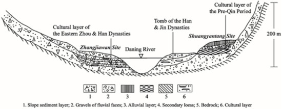
Figure 3. Fluvial geomorphology and strata of the Zhangjiawan and Shuangyantang Sites in the Daning River Valley, Three Gorges area of the Yangtze River.
2.1.2. The Shu Cultural Area of the Chengdu Plain
The latest archaeological information shows that the civilization between the Ne-olithic Age and ancient Shu Culture in the Chengdu Plain is mainly divided into five periods: the Guiyuanqiao Culture (5.1–4.6 ka BP), Baodun Culture (4.8–3.7 ka BP), the Sanxingdui Culture (3.7–3.0 ka BP), the Jinsha-Shierqiao Culture (3.0–2.5 ka BP), and late Shu Culture (2.5–2.3 ka BP) [88][89]. The Qin Dynasty exterminated Ba and Shu in 316 BC. By the time of the Emperor Wu Period in the mid-Western Han Dynasty (156–87 BC), the Ba-Shu Culture had eventually integrated into the Han Culture, and the history of the ancient Shu Kingdom thus ended. The ancient Shu civilization finally became an integral part of the Chinese civilization community. However, the Guiyu-anqiao Culture, Baodun Culture, Sanxingdui Culture, and Jinsha Culture all lack writ-ten records from the Neolithic Age to the ancient Shu civilization. Recently, by com-paring multiple paleoclimatic proxies from regions mainly controlled by the Indian Monsoon, Zeng et al. [56] found that climate deterioration (a sustained cooling climate with increasing numbers of flood events) during the “Holocene Event 3” (or “4.0 ka BP Event”, also sometimes called the “4.2 ka BP Event”) hindered the sustainable devel-opment of the Baodun Culture, eventually contributing to its decline. Specifically, cli-mate was an important factor that caused changes in the subsistence strategy and spa-tiotemporal distribution of human settlement sites in the Chengdu Plain during the Baodun period. The cooling climate and widespread floods that occurred approxi-mately 4.0 cal. ka BP had significant impacts on walled sites and agriculture. Further-more, the geographic background of the fluvial plain and the hydrographic system, the variations in the agricultural system, the frequent migrations, and the increased risk of flooding all had significant effects that made the development of this culture difficult. All of these factors influenced the cultural evolution and human activity and eventu-ally impacted the decline of the Baodun Culture, although the climatic effect of the “4.2–4.0 ka BP Event” was significant [52]. The survival strategies that were employed during the Baodun period, including migration, site selection, flood-control methods, diversification of food resources, and agricultural changes, possibly indicate how an-cient humans responded to climate change. Another view is that the period when sudden flooding occurred frequently in the Chengdu Plain was 4.0–3.6 ka BP, contem-poraneous with an ancient global flooding event, and this paleoflood event probably brought about the extinction of the Baodun Culture [57]. Of course, the research out-lined above conveys a form of environmental determinism. The exact causes of the rise and fall of civilizations during the above important cultural stages of the ancient Shu civilization in the upper reaches of the Yangtze River have not yet been scientifically and convincingly explained [90][91]. More evidence and consilience of knowledge are needed in the future works.
2.1.3. Background of Environmental Evolution Derived from Typical Natural Sedimen-tary Records
In the comparative study of site distribution, site stratum, and natural sediment, the identified results of 121 surface sediment sporopollen samples in Shennongjia and the 30-year meteorological database for 7 meteorological stations around Dajiuhu, Shennongjia, were used [92]. Selecting 55 species of common sporopollen with the method of space fitting and stepwise regression, Zhu et al. [72] constructed the spo-ropollen climate factor transfer function of annual mean temperature and tested it us-ing the sporopollen samples concentration percentage in a 297-cm-thick peat section in Dajiuhu from 15.753 ka BP, which is an important reference value for studying climate change since the last glacial period. At the same time, the peat humification contrast between Dajiuhu and Qianmutian, the δ18O records of stalagmites in Dongge Cave in Guizhou Province, and such high-resolution records as the δ18O of stalagmites in Shanbao Cave in Shennongjia revealed the characteristics of Holocene temperature and monsoon precipitation in the Shennongjia area [93][94][95][96]. During the early Holocene, this area was relatively cold and wet in general [96][97]. Significant drought events ap-peared around 10.6 cal. ka BP, and the temperature dropped around 8.2 cal. ka BP [96][97]. The Holocene climatic optimum was 6.7–4.2 cal. ka BP, and there was a decline in monsoon events accompanied by a sharp decline in precipitation at around 4.2 cal. ka BP [72][96], which may have impacted on the development of the Neolithic culture. The driest peak appeared around 3.7 cal. ka BP, from which precipitation levels then quickly rebounded [96]. The monsoon precipitation intensity from 3.5 to 0.9 cal. ka BP was relatively weak. However, monsoon rainfall increased after 0.9 cal. ka BP, and the peat absorbance gradually decreased. All of these changes came in response to the uniform driving of summer solar radiation in the Northern Hemisphere [53][79][97].
Combined with the above natural sedimentary records, a comprehensive inte-grated analysis shows that there are eight paleoflood layers in the archaeological site strata during the Holocene climatic optimum of 6.7–4.2 ka BP, i.e., the 4th, 5th, 6th, 7th, 8th, and 10th strata of the Yuxi Site and the 76-2 and 50-1 strata of the Zhongba Site [71][75]. From 3.5 to 0.9 ka BP, when the precipitation dropped, there are only two flood layers in the Zhongba Site, i.e., the 37-1 strata in the Western Zhou Dynasty and the 21 strata in the early Warring States Period. There have been 3 flood layers in the Zhong-ba Site since 0.9 ka BP, when there has been more precipitation, i.e., the 11C-1 strata in the mid-Song Dynasty, the 5-1 strata in the Qing Dynasty, and the 2B-2 strata in 1981. The above contrast fully embodies the agreement between the archaeological site stra-ta and the natural sedimentary records [76][77].
2.2. The Middle Reaches of the Yangtze River
The progress of environmental archaeology in the middle reaches of the Yangtze River mainly involves regional environmental archaeology of the Qujialing-Shijiahe cultural system that primarily developed on the Jianghan-Dongting Plain (Figure 1). In addition, there have been quite a few remarkable relevant research results from the Hanjiang River Valley.
2.2.1. Spatiotemporal Distribution of Human Sites
Li et al. [98] adopted data on the spatiotemporal distribution of 1362 sites in Hubei from the Paleolithic Age to the Warring States Period unearthed by archaeologists and obtained by field investigation in past years and plotted them on a relief map with dif-ferent elevation layering and colors using MapInfo vector drawings. Then, combined with topography and the sporopollen records of the peat strata continuously deposited since the late glacial period in Dajiuhu [77][99], the relationship between regional hu-man activities and topographical and environmental evolution was examined. This re-vealed that the spatiotemporal distribution of the sites in this area is mainly affected by changes in hydrological regimes, river terraces, and climatic conditions. Liu et al. [100] investigated the response of the migration of Neolithic settlements to changes of the lake and monsoon climate in the Lake Dongting area by combining sedimentology and geoarchaeology. Deng et al. [101] systematically analyzed the evolution of the dis-tribution of 7534 ancient cultural sites in the Jianghan-Dongting Plain since 8.5 ka BP using ArcGIS from the perspective of environmental archaeology. Their results indi-cate that the spatial distributions of cultural sites in different eras vary significantly. The Neolithic sites were mainly distributed on the loess terra in the piedmont hills and high alluvial plains, where the elevation was higher and the slope varied. During the Western Zhou Dynasty, the main distribution of cultural sites shifted from the loess terra to the alluvial plain, with lower elevations and gentler slopes. From the Qin Dynasty to the Qing Dynasty, the cultural sites were mainly located in the lowest allu-vial plain and the lake-deposit plain. This reflects the response of human activities to natural environmental changes at different levels of productivity.
In addition to the Jianghan-Dongting regions, there are many research results worth noting in the Hanjiang River Valley, which is also in the middle reaches of the Yangtze River. Li et al. [102] examined the spatial processes of Daxi, Qujialing, and Shi-jiahe cultural sites during the Neolithic Age in the middle and lower reaches of the Hanjiang River through the use of the trend surface method and discovered that the spatial evolution of the Neolithic culture in the middle and lower reaches of the Han-jiang River roughly divided into two stages: Qujialing cultural sites diffused to the up-per reaches along the Yunshui River and the main stream of the Hanjiang River, while the Shijiahe cultural sites were characterized by shrinkage, mainly aggregated along a Danjiang–Zaoyang–Suizhou line. Combined with the changes in climate and landform that occurred during the mid-Holocene, the site distribution patterns and elevation changes of the sites in the middle and lower reaches of the Hanjiang River were inter-preted to reflect the influences of paleofloods and lake expansion. The characteristics of site diffusion and aggregation are closely related to such social factors as agricultur-al production and cultural integration. Li et al. [103] conducted systematic research on the relationship between the spatiotemporal distribution of the Neolithic sites and the geographic background in the upper reaches of the Hanjiang River and found that the tectonic and geomorphologic conditions restricted the distribution of the Neolithic sites. Further comparative analysis also showed that the rise and fall of culture in the upper reaches of the Hanjiang River exhibited a good coupling relationship with Hol-ocene environmental evolution, reflecting the complicated and dynamic evolution of human–landscape interactions in the Neolithic Age.
2.2.2. Archaeological Stratigraphy Research in Typical Sites
By relying on 14C dating of the stratigraphy at the Chengtoushan Site in Lixian County, Hunan Province, and through the identification of rice, plant megafossils, sporopollen, and phytoliths unearthed in the strata of the site, Yasuda et al. [104] dis-covered that the end of the Daxi, Qujialing, and Shijiahe Cultures in the Liyang Plain during the Neolithic Age corresponded to the climate deterioration period, which was also the period when the intensity of the summer monsoons weakened. It is theorized that the widespread decline of summer monsoons, coupled with climatic drought events, over the Eurasian continent from 4.2 to 4.0 cal. ka BP caused precipitation, which was required by agricultural irrigation, to decline precipitously, thus resulting in the decline of the Shijiahe Neolithic Culture [104]. However, Li et al. [105] and Wu et al. [106] discovered a large range of extreme flood events in the middle and late stages of the Qujialing Culture (4.9–4.6 cal. ka BP) and between the late Shijiahe Culture and the Xia Dynasty (4.1–3.8 cal. ka BP) in the Jianghan Plain (Figure 4). Their findings were based on comprehensive research on archaeological stratigraphy, geochronology, spo-ropollen, grain size, zircon micromorphology, magnetic susceptibility, geochemistry, and other multi-proxy indicators of paleoflood events in the typical sites of the late mid-Holocene in the Zhongqiao, Tanjialing, and Sanfangwan Sites in the Jianghan Plain (Figure 4), combined with the comparative analysis of the characteristics of mod-ern flood sediment in the area, changes in the spatiotemporal distribution of cultural sites, and stratigraphic accumulation characteristics, and statistical information of pa-rameters such as geographic location, chronology, terrain elevation, paleoflood layer depth, and cultural layer thickness for many mid-Holocene archaeological sites in the Jianghan Plain [43][63][106][107][108]. They also suggested that the decline of the Shijiahe Culture is related to the formation of an extremely complex socioeconomic union be-cause the invasion of external forces might lead to the decline of a highly centralized social and economic system. Evidence of increased social conflicts is reflected in the increasingly common phenomenon of missing heads or incomplete skeletons in the archaeological remains of the period, increases in the number of unearthed arrow-heads of various forms and other aspects [109][110]. There are also records for saying “Sanmiao was in chaos”, “Yu conquered Sanmiao”, etc., in ancient documents [111]. The intensified discrepancy between social development (including the political con-flicts from internal or other cultural areas) and environmental change processes (espe-cially the hydrological process or extraordinary floods) during the late Shijiahe cultural period might be the important factors to accelerate the decline of the Shijiahe Culture [63][106]. In terms of environmental reconstruction of individual site, Li et al. [112][113] restored the vegetation succession and environmental change process of the Shijiahe cultural period through a comprehensive analysis of sporopollen and total organic carbon (TOC), total nitrogen (TN), and organic carbon isotope (δ13Corg) from Tanjialing Site’s strata and found that the ancient city of Shijiahe initially played a significant role in preventing floods and foreign enemy invasion. The climate continued to cool and get drier until 4.2 ka BP, affecting the development of local agriculture, fishing, and hunting. Meanwhile, the underground water level and flood level dropped, the flood control pressure decreased, the defensive role of the city naturally weakened, the trenches gradually filled up, and the ancient city was abandoned.
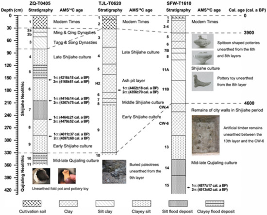
Figure 4. Stratigraphic correlation between the ZQ-T0405 (at the Zhongqiao Neolithic site) and SFW-T1610 (at the Sanfangwan Neolithic site) profiles containing mid-late Holocene paleoflood deposits and the TJL-T0620 profile at the Tanjialing Neolithic site in the Jianghan Plain, middle reaches of the Yangtze River.
In addition, Li et al. [114] conducted environmental archaeology research on the Liaowadian Site in the upper and middle reaches of the Hanjiang River, using ele-mental geochemical methods to restore the environmental changes and human activi-ties recorded in the cultural layers of the Xia Dynasty, the Eastern Zhou Dynasty, and the Ming and Qing Dynasties in the site strata. They also discovered that the frequency of Hanjiang River flooding and seasonal mountain torrents had been increasing since the Eastern Zhou Dynasty. The original ecosystem in this region had been destroyed, and the positive feedback effect of human activities on nature had been more apparent. Through additional field investigations, the sedimentary records of the Holocene flood events were also discovered in the Wufeng section of Yunxian County (e.g., the Lijiazui and Tuojiazhou profiles containing the Shijiahe, Zhou, and Han cultural layers) and in the upper reaches of the Hanjiang River [115]. Based on stratigraphic correlation, ar-chaeological dating of the cultural layers, and optically-stimulated luminescence (OSL) dating, four extraordinary flood events since the Holocene were determined in this ar-ea. In addition, the paleoflood water level and flood peak flow were calculated and re-stored.
2.2.3. Comparative Research on Site Distributions, Site Strata, and Natural Sedimentary Records
The main results of this facet of environmental archaeology have been concen-trated in the Jianghan Plain [63][106][109][116][117][118][119][120][121]. Based on extensive field investiga-tions and comprehensive laboratory research of borehole sediments, stalagmites, and lacustrine sediments in the Jianghan Plain, combined with previous research results on the sedimentation of rivers and lakes, archaeological stratigraphy, and site distribu-tion, Gu et al. [121][122] explored the relationship between climate change, human ac-tivities, and the evolution of the Jianghan lakes over 20,000 years. Wang et al. [123] and Li et al. [105] used AMS 14C dating to establish the time sequences of environmental evolution since 12.76 cal. ka BP in the Jianghan Plain, with the object of study being the JZ-2010 lacustrine sedimentary section. Comprehensive analyses of multiple indicators indicate that the regional moisture turned from relatively dry to wet after the late-glacial period and reached its optimum until the mid-Holocene. However, the trend was punctuated by several decreased humidity phases. Beginning with the se-vere dry event approximately 4.4–4.1 cal. ka BP, the environment was dry as a whole. Humidity changes in the study area are dominated by the East Asian monsoon system, which is under the influence of the gradual southward migration of the ITCZ, driven by the summer solar insolation changes in the Northern Hemisphere due to orbital forcing. It was also found that the fluctuation of magnetic susceptibility values in the JZ-2010 profile reveals anthropogenic effects on the deposition rate and the land use types in drainage basins. An increased magnetic susceptibility value indicated intensi-fied bedrock erosion caused by farming and deforestation. Thus, the magnetic suscep-tibility (particularly, the abnormal value segments) reflected the alternating Neolithic cultural types (Daxi Culture, 6.4-5.3 ka BP → Qujialing Culture, 5.0-4.6 ka BP → Shijiahe Culture, 4.6-4.0 ka BP) of the Jianghan Plain [105]. Based on the aforementioned re-search, Li [124] also explored the environmental changes from 5.5 to 3.4 ka BP in the Jianghan Plain and the impact of these changes on the succession of ancient cultures.
The main research of Lake Dongting in this regard consisted of the comprehen-sive investigation of the geochemical characteristics of 21 sites, 114 cultural layers, and the natural sedimentary strata of different ages and topsoil samples in the Liyang Plain [125]. The results reflected the ancient natural and human environmental characteris-tics of different natural and cultural stages in this area. It can be seen that dramatic changes in Neolithic cultures in the middle reaches of the Yangtze River approximately 4.0 cal. ka BP were also affected by climate change and associated consequences (e.g., the local topography, climate zone, and survival strategy), comparable to the upper reaches of the Yangtze River [106][113]. In the early and middle Shijiahe cultural period, population growth and rice cultivation development continuously stimulated human activities to expand to the hinterlands of the low-lying Jianghan-Dongting Plain [106][110][126]. Subsequently, fluctuations in the water level of rivers and lakes precipi-tated flood disasters and increased the threat from floods at the end of the Shijiahe cultural period [63][106][119]. The discrepancy between social development and envi-ronmental change processes, especially hydrological processes, became particularly prominent at the end of the Shijiahe cultural period and were the main cause of the demise of this culture [63][110][126]. The extraordinarily severe floods caused by climate anomalies around 4.0 cal. ka BP, which were of global significance, and conflicts within the area or between inhabitants of the area and those of the Central Plains and other areas at the end of the Shijiahe cultural period, accelerated the decline of the Shijiahe Culture [63][106][113]. Taking the Jianghan Plain as an example, only ten settlement sites between the end of the Shijiahe cultural period and the Xia Dynasty remain after 4.0 cal. ka BP (Figure 5), all of which are located at an altitude above 50 m, indicating that significant flood events actually occurred during that period, and the inhabitants were forced to live in high-altitude areas [43][106]. However, there is still a need for further analysis of the comparative research between archaeological strata and natural sedi-mentary records in the middle reaches of the Yangtze River. Therefore, interpreting this as a breakthrough in terms of research perspective, we can further explore the changing mechanisms of the geographic environment and their impacts on the succes-sion of archaeological cultures. In addition, we can analyze the causes of the interrup-tion or disappearance of archaeological cultures to answer the scientific questions re-garding the dynamic changes in the human–landscape interactions in this area.
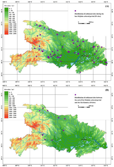
Figure 5. Distribution change of settlement sites before and after the 4.0 ka BP event in and around the Jianghan Plain area. (A) Distribution of settlement sites during the late Shijiahe cul-tural period (4.2–4.0 ka BP) in and around the Jianghan Plain area; and (B) distribution of set-tlement sites between the end of the Shijiahe cultural period and the Xia Dynasty (4.0–3.5 ka BP) in and around the Jianghan Plain area.
2.3. The Lower Reaches of the Yangtze River
Research content of environmental archaeology in the lower reaches of the Yang-tze River is abundant, with both a multi-indicator analysis for typical site strata and comprehensive exploration on the spatiotemporal distribution of regional settlement sites, consisting of study on human living environments and analyses of the impacts of climate event and environmental evolution on human life and production.
2.3.1. Spatiotemporal Distribution Research of Archaeological Sites and Ancient Water Wells
With regard to the investigation of regional sites and the comprehensive discus-sion of their spatiotemporal distribution, the spatial and temporal distribution of Neo-lithic sites in the Yangtze River Delta and the identification characteristics of marine foraminifera revealed that this area lacked Neolithic sites from the beginning of Holo-cene until 7 ka BP [127]. From 7 to 4 ka BP, Neolithic sites appeared continuously and the number of such sites gradually increased, suggesting great development of prehis-toric civilization in this area. Among these archaeological sites, the marine foraminif-era appear in the strata below the Majiabang cultural layer. With the exception of the area east of the chenier ridges of Maqiao in Shanghai, no marine foraminifera have been found in the strata since 7 ka BP in this area, indicating that the greatest Holocene transgression should have occurred between 10 and 7 ka BP [127]. Wu et al. [128] ana-lyzed the spatiotemporal distribution characteristics of settlement sites in the Lake Chaohu Basin of Anhui from the middle and late Neolithic Age to the Han Dynasty, mainly discussing the response of the ancient settlements in the basin to environmen-tal evolution. The results showed that as time went on, the settlement sites in the Chaohu area gradually moved from high to low altitudes and approached the lakes. However, the distribution pattern of the settlement sites in each period was related to the geomorphologic conditions in the eastern part of the basin, which were highly susceptible to river swings and flood disasters. Wu et al. [21][61][62][129], Luo et al. [130], and Zong et al. [131] also extensively used a large quantity of chronology, micropale-ontology, and sedimentary borehole data, in combination with archaeological site sur-veys and geographic information technologies, to explore the impact of ancient water landscape and Holocene environmental changes of Anhui, Shanghai, and Zhejiang on the rise and fall of prehistoric cultures and settlement transmutations.
Recently, Zhu et al. [43][60] developed statistical information on the quantity, loca-tion, and elevation of the ancient wells unearthed in the Lake Taihu area between 7 ka BP and the Tang Dynasty (618–907 AD) and discerned some important rules. From the statistics of 20 sites and 157 wells identified to be from 7 to 3 ka BP in the Lake Taihu area, there are 121 wells from the Liangzhu cultural period, accounting for 77% of the total number of wells in the Neolithic Age, which was the period with the most dis-covered ancient wells. Ancient wells are densely distributed on the eastern Taihu Plain at locations with an elevation below 5 m (i.e., the plains of Lake Yangcheng, Lake Chenghu, and Lake Dianshan); there are fewer ancient wells in other areas of the Lake Taihu Basin. Based on the statistical analysis of the depth elevation of ancient wells in Lake Chenghu and Lake Dushu in Suzhou, it was discovered that during the Songze cultural period the groundwater level in the dry season ranged between −1.5 and −1.8 m, while the lowest groundwater level in the dry season was below −2.5 m during the Liangzhu cultural period. The groundwater level in the Maqiao cultural period rose back to a maximum depth of −1.7 m. The above research on the wellhead elevation of ancient wells confirmed that there was no Holocene transgression in this area from 7 to 3 ka BP; the wells’ ages in Lake Chenghu were distributed continuously from the Neolithic Age to the Song Dynasty, proving that the formation of Lake Chenghu took place during or after the Song Dynasty (960–1279 AD). Zheng et al. [17] also investi-gated more than 2000 prehistoric sites and sites from the Shang and Zhou Dynasties in coastal China, 655 of which were from the Neolithic Age, using Digital Elevation Mod-el (DEM) and GIS methods. Their results suggest that the spatial and temporal distribution of Neolithic sites was largely controlled by landform evolution (particu-larly coastline changes), which were ultimately governed by sea level changes.
2.3.2. Archaeological Stratigraphy Research on Typical Sites
In comprehensive research on typical Neolithic sites, Yu et al. [132] studied a sec-tion of the Caoxieshan Site, Suzhou, located on the eastern plain of Lake Taihu, using data and methods such as sporopollen, grain size, and magnetic susceptibility analysis and found that at approximately 5.4 and 5.2 ka BP there were brief droughts in the site area that might impact on the gradual decline of the Songze Culture and the emer-gence of regional irrigation agriculture. However, the particular linkages between cli-mate change, environmental stress, agricultural impacts, and human response are un-clear. Zhang et al. [133] studied the environmental changes in the Yangtze River Delta over the past 7000 years, in combination with the collected records of many archaeo-logical and natural strata in that area, and discovered that a marine regression process between 7.2 and 5.3 ka BP provided a vast space for human activities in the Liangzhu cultural period. Zhang et al. [134] examined the regional climate change and living en-vironment of the Chuodun Site in Jiangsu using sporopollen analysis and concluded that the rise and fall of Neolithic culture in the Lake Taihu area was closely related to changes in terrain, climate, and sea level in the area, and the development of the dish lake basin system of Lake Taihu, not just a simple consideration of climate change. Chen et al. [135] analyzed stratigraphic profile samples of the Guangfulin Site in Shanghai in terms of grain size, sporopollen, organic carbon content, magnetic charac-teristics of the soil, micropaleontology, and elemental geochemistry and discovered that prior to human habitation the climate was relatively dry. The climate was then warm and humid during the Liangzhu cultural period, while the climate in the Guangfulin cultural period was increasingly cool and dry, with a relatively harsh en-vironment, although the temperatures between the Warring States Period and the Han Dynasty were relatively high. Based on the archaeological excavations of the Luotuo-dun Site in Yixing, Jiangsu, Li et al. [136] combined the 14C dating data of samples from four related strata and made foraminifera, plant clast, and seed fossil identifications for 63 samples in the stratigraphic profile of the site, finding one genus and two species of benthic foraminifera in the 10th peat layer, namely, Ammonia compressiuscula and a sim-ilar type that is a close relative of Ammonia. Ammonia is euryhalic and is a common species in brackish water near the intertidal zones of modern coasts. It can be seen from the topography of the site that the marine foraminifer is a typical heterochtho-nous burial type in this area, which may have been transported in seawater to the area for deposition. It is thus inferred that since the Holocene and before the Luotuodun Site and its adjacent Majiabang Culture came into being, there was a transgression event between 7500 and 5400 BC. This occurrence is consistent with the marine micro-paleontological characteristics of the transgression layer in Zhenjiang during the Hol-ocene derived from drilling samples by Lin et al. [137], indicating that the Lake Taihu area was a marine sedimentary environment between the early Holocene and 7 ka BP. The identification of marine micropaleontology indicates that there was still a shallow sea sedimentary environment from the beginning of the Holocene to 7.8 cal. ka BP in the region of Hai’an and Dongtai in the northern margin of the Yangtze River Valley [60]. For example, there are lots of microfossils of planktonic foraminifera, benthic foraminifera, and ostracoda identified from the lower marine strata (12.6–9.2 cal. ka BP) at the Taozhuang Neolithic site of Dongtai. By using sedimentary proxies, including Sr, calcium content, grain size, diatoms, and dinoflagellates, Ling et al. [138] also suggest-ed that during the middle to late Holocene (after ca. 7.6 cal. ka BP), the deposits mainly originated from overbank flooding or from storm surge events rather than from direct RSL rise from ca. 7.6–6.6 cal ka BP in the Liangzhu area. The Liangzhu Ancient City ar-ea remained a swamp and an area of salinization until ca. 5.1 cal. ka BP. Another study presented an analysis of the chronology, sedimentology, and organic and alka-line-earth metal geochemistry (Sr/Ba ratio, δ13C value, etc.) of a profile collected from the Xiawangdu Neolithic site on the Ningbo Plain [139]. They found that frequent ex-treme typhoon events occurred during both periods. In response to the flooding, the Neolithic people either abandoned the low-lying land close to the river channel or re-treated to dwellings constructed on earth mounds.
In the case of Shanghai, the stratigraphic profile of the Maqiao Site consists of 9 layers, with Layers 2a, 3, and 5 being cultural layers, Layers 2b, 4, and 6 being cultural interruption layers (i.e., natural fine sand or mud, peat and bog-iron layers, the absence of cultural relics between two cultural layers), and Layer 8 being the ancient coastal shell ridges around 6 ka BP [140]. No foraminifera were found in layer 6 (the age of the middle is 5.5 ka BP), which is a marker horizon of the formation of land in the region of Shanghai [43][140]. According to 14C dating, along with foraminifera and sporopollen identification of the stratum samples in the Maqiao Site, it was found that in the At-lantic Ocean period (7.45–4.45 ka BP), the Maqiao area in Shanghai experienced a changing sedimentary environment process that took the form successively of inland shallow sea, onshore intertidal zone, onshore supratidal zone and onshore freshwater lakes and marshes. During the sub-boreal period (4.45–2.45 ka BP), this area experi-enced a changing process that took the form successively of dry cool onshore envi-ronment, flood water lake and marsh, and warm-humid onshore environment. In the sub-Atlantic period (2.45 ka BP to present), it has experienced flooding lake and marsh environments accompanied by fluctuations in temperature, but in general, the envi-ronment has been warm and humid. Furthermore, this area has experienced three dis-tinctly unfavorable environments for the survival and development of humans fol-lowing land formation; i.e., before the formation of the Liangzhu Culture and at the end of it and from the Shang and Zhou Dynasties until the Tang Dynasty, resulting in three obvious cultural interruption layers. All lines of evidence, including landform development, fluvial and lacustrine deposits, fossil bones, and micropaleontology, clearly indicate that these cultural interruption layers were mainly caused by the lake expansion due to land floods over a long period of time, none of which were related to a transgression [43][127][140].
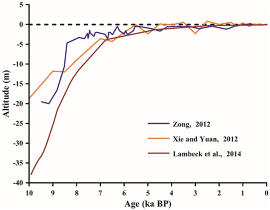
The Liangzhu Culture (5.0–4.0 ka BP), which included a developed jade industry in the Yangtze River Delta, suddenly disappeared around 4.0 ka BP. In the strata of the site from the same period, a natural silt layer without any cultural relics lies above the cultural layer. Above the silt layer is the Maqiao cultural layer, which was character-ized by the artifacts of the Yellow River during the Xia and Shang Dynasties. This stratification indicates that human civilization suffered serious catastrophic events at that time [140]. Research on the deposited foraminifera, sporopollen, and sedimentol-ogy revealed that no foraminifera were found above the Liangzhu cultural layer of the Maqiao Site in Shanghai, although there was hydrophyte sporopollen. Thus, it was speculated that there was no transgression, but there had been cataclysmic land-flooding events. From the curves of sea level changes during the Holocene in East China and their comparison with the global curve (Figure 6), it can also be observed that there was no high sea level and transgression from 5.0 to 4.0 ka BP in Eastern China, including the Yangtze Delta [19][141][142][143]. Another point worth noting is that, after 4.0 ka BP, as represented by the Maqiao Culture, the distribution area of each pre-historic culture contracted, a phenomenon that was simultaneously accompanied by two different modes of production (rice farming vs. hunting and gathering) and eco-nomic transitions [43][61][62]. Wu et al. [61][62] also performed further analysis that re-vealed that climate change triggered modifications to production-lifestyles and eco-nomic forms, which induced prehistoric inhabitants to change their area of activity and even brought about the rise of a new cultural form. However, the cause of the location of the Liangzhu Culture and the origins of the Maqiao Culture have yet to be conclu-sively determined and are still being studied in depth [144].
2.3.3. Comparative Research on Site Distributions, Site Strata, and Natural Sedimentary Records
In recent years, environmental archaeology research involving the environmental evolution background of the sedimentary strata in the lower reaches of the Yangtze River has mainly focused on the Qianmutian profile of Mt. Tianmu [96][145], supple-mented by the Linfengqiao profile in Nanjing [146]. Two sediment cores in the south Taihu Plain were also analyzed to improve understanding of the geomorphological and hydrological context for evolution of prehistoric rice agriculture [147]. Through a com-prehensive analysis of radiocarbon dating, sporopollen, diatoms, δ13C and δ15N, grain size and lithology, magnetic susceptibility, Rb and Sr content, Rb/Sr ratio, and other environmental proxy indicators, the regional paleoclimate and the environmental evo-lution background were reconstructed and used for comparative research with site strata and site distributions [146][147][148].
The results showed that during the Majiabang cultural period, sea water penetra-tion influenced the largest area of the Taihu Plain occurred at ca. 7.0-6.50 cal. ka BP. Sporopollen, organic carbon isotope δ13C, magnetic susceptibility, and Rb/Sr all had high values in the peat profile of Qianmutian during this period, indicating that the climate was warm and humid. The sea level of the Lake Taihu area was relatively sta-ble, and the vegetation was characterized by evergreen broad-leaved forests, which experienced low temperatures and flood events 6.4 and 6 ka BP.
Compared with the Majiabang cultural period, the sporopollen analysis of the Qianmutian profile showed that during the Songze cultural period, the content of ev-ergreen broad-leaved species gradually decreased, the content of temperate deciduous broad-leaved species gradually increased, and the pollen content of the herbaceous plants significantly increased during the middle and late stages. The values of δ13Corg, magnetic susceptibility, and Rb/Sr exhibited their lowest values throughout the profile during this period. All of these data reflect the fact that, compared to the Majiabang cultural period, both the temperature and precipitation in the Songze cultural period were noticeably lower. The sea surface was also lower than that of the previous period, with a certain amount of fluctuation. Stable freshwater environments persisted after ca. 5.6 cal. ka BP. The climate experienced a change from warm-humid to warm-dry to warm-humid, resulting in a stratigraphic gap in the cultural layers of many site pro-files from this period. There were especially strong cooling and flooding events ap-proximately 5.5 ka BP [149].
During the Liangzhu cultural period, the climate was slightly cool and dry. The sporopollen analysis of the Qianmutian stratum showed that the vegetation at that time was coniferous and broad-leaved mixed forest and grassland dominated by conif-erous species, reflecting a slightly dry and cool climatic environment. For the Qianmu-tian peat stratum, δ13Corg, magnetic susceptibility, and Rb/Sr ratios were all higher than the corresponding values of the previous period, demonstrating an increasing trend, which indicated that the climate in the Liangzhu cultural period generally tended to be warm and dry, with the exception of a short warm and wet stage early in the period. Increased freshwater supply caused by water system change promoted the rapid rise of rice farming during the Liangzhu period. Significant cooling and flooding events occurred late in the Liangzhu cultural period (approximately 4.0 ka BP).
References
- Chambers, F.M. Climate Change and Human Impact on the Landscape: Studies in Palaeoecology and Environmental Archaeology; Springer: Dordrecht, The Netherlands, 1993.
- Dincauze, D.F. Environmental Archaeology: Principles and Practice; Cambridge University Press: Cambridge, UK, 2000.
- Reitz, E.; Shackley, M. Environmental Archaeology; Springer: Berlin/Heidelberg, Germany, 2012.
- Zhou, K.S. Nature and Humanity; Science Press: Beijing, China, 2012. (In Chinese)
- Mo, D.W.; Chen, F.H.; Wang, H. Environmental Archaeology Research; Science Press: Beijing, China, 2016; Volume 5. (In Chinese)
- Pişkin, E.; Marciniak, A.; Bartkowiak, M. Environmental Archaeology: Current Theoretical and Methodological Approaches; Springer Intentional Publishing: Cham, Switzerland, 2018.
- Chen, F.H.; Welker, F.; Shen, C.-C.; Bailey, S.E.; Bergmann, I.; Davis, S.; Xia, H.; Wang, H.; Fischer, R.; Freidline, S.E.; et al. A late Middle Pleistocene Denisovan mandible from the Tibetan Plateau. Nature 2019, 569, 409–412.
- Guo, H.D.; Wang, X.Y.; Chen, F.L.; Wang, C. An Introduction to Space Archaeology; Science Press: Beijing, China, 2020. (In Chinese)
- Luo, L.; Wang, X.Y.; Guo, H.D.; Lasaponara, R.; Zong, X.; Masini, N.; Wang, G.Z.; Shi, P.L.; Khatteli, H.; Chen, F.L.; et al. Airborne and spaceborne remote sensing for archaeological and cultural heritage applications: A review of the century (1907–2017). Remote Sens. Environ. 2019, 232, 111280.
- Branch, N. Environmental archaeology. Int. Encycl. Soc. Behav. Sci. 2015.
- Chen, F.H.; Dong, G.H.; Zhang, D.J.; Liu, X.Y.; Jia, X.; An, C.B.; Ma, M.M.; Xie, Y.W.; Barton, L.; Ren, X.Y.; et al. Agriculture facilitated permanent human occupation of the Tibetan Plateau after 3600 B.P. Science 2015, 347, 248–250.
- Dong, G.H.; Zhang, D.J.; Liu, X.Y.; Liu, F.W.; Chen, F.H.; Jones, M. Response to Comment on “Agriculture facilitated permanent human occupation of the Tibetan Plateau after 3600 B.P.”. Science 2015, 348, 872.
- Latorre, C.; Wilmshurst, J.M.; von Gunten, L. Climate change and cultural evolution. Past Glob. Chang. Mag. 2016, 24, 53–84.
- Wu, Q.L.; Zhao, Z.J.; Liu, L.; Granger, D.E.; Wang, H.; Cohen, D.J.; Wu, X.H.; Ye, M.L.; Bar-Yosef, O.; Lu, B.; et al. Outburst flood at 1920 BCE supports historicity of China’s Great Flood and the Xia dynasty. Science 2016, 353, 579–582.
- Huang, C.C.; Zhou, Y.L.; Zhang, Y.Z.; Guo, Y.Q.; Pang, J.L.; Zhou, Q.; Liu, T.; Zha, X.C. Comment on “Outburst flood at 1920 BCE supports historicity of China’s Great Flood and the Xia dynasty”. Science 2017, 355, 1382.
- Gaillard-Lemdahl, M.-J.; Whitehouse, N.; Madella, M.; Morrison, K.; von Gunten, L. Past land use and land cover. Past Glob. Chang. Mag. 2018, 26, 1–44.
- Zheng, H.B.; Zhou, Y.S.; Yang, Q.; Hu, Z.J.; Ling, G.J.; Zhang, J.Z.; Gu, C.G.; Wang, Y.Y.; Cao, Y.T.; Huang, X.R.; et al. Spatial and temporal distribution of Neolithic sites in coastal China: Sea level changes, geomorphic evolution and human adaption. Sci. China: Earth Sci. 2018, 61, 123–133.
- Gayo, E.M.; McRostie, V.B.; Campbell, R.; Flores, C.; Maldonado, A.; Uribe-Rodriguez, M.; Moreno, P.I.; Santoro, C.M.; Christie, D.A.; Muñoz, A.A.; et al. Geohistorical records of the Anthropocene in Chile. Elem. Sci. Anthr. 2019, 7, 1–31.
- Sun, Q.L.; Liu, Y.; Wünnemann, B.; Peng, Y.J.; Jiang, X.Z.; Deng, L.J.; Chen, J.; Li, M.T.; Chen, Z.Y. Climate as a factor for Neolithic cultural collapses approximately 4000 years BP in China. Earth-Sci. Rev. 2019, 197, 102915.
- Liu, Y.; Deng, L.J.; He, J.; Jiang, R.; Fan, D.D.; Jiang, X.Z.; Jiang, F.; Li, M.T.; Chen, J.; Chen, Z.Y.; et al. Early to middle Holocene rice cultivation in response to coastal environmental transitions along the South Hangzhou Bay of eastern China. Palaeogeogr. Palaeoclimatol. Palaeoecol. 2020, 555, 109872.
- Wu, L.; Sun, X.L.; Sun, W.; Zhu, C.; Zhu, T.X.; Lu, S.G.; Zhou, H.; Guo, Q.C.; Guan, H.C.; Xie, W.; et al. Evolution of Neolithic site distribution (9.0–4.0 ka BP) in Anhui, East China. J. Geogr. Sci. 2020, 30, 1451–1466.
- Albarella, U. Environmental Archaeology: Meaning and Purpose; Springer: Dordrecht, The Netherlands, 2001.
- Redman, C.L.; James, S.R.; Fish, P.R.; Rogers, J.D. The Archaeology of Global Change: The Impact of Humans on Their Environment; Smithsonian Institution: Washington, DC, USA, 2004.
- Innes, J.B.; Zong, Y.; Wang, Z.; Chen, Z. Climatic and palaeoecological changes during the mid- to Late Holocene transition in eastern China: High-resolution pollen and non-pollen palynomorph analysis at Pingwang, Yangtze coastal lowlands. Quat. Sci. Rev. 2014, 99, 164–175.
- Kajita, H.; Kawahata, H.; Wang, K.; Zheng, H.B.; Yang, S.Y.; Ohkouchi, N.; Utsunomiya, M.; Zhou, B.; Zheng, B. Extraordinary cold episodes during the mid-Holocene in the Yangtze delta: Interruption of the earliest rice cultivating civilization. Quat. Sci. Rev. 2018, 201, 418–428.
- Qin, Z. Exploring the early anthropocene: Implications from the long-term human-climate interactions in early China. Mediterr. Archaeol. Archaeom. 2021, 21, 133–148.
- Jackson, L.J.; Hinshelwood, A. The Late Palaeo-Indian Great Lakes: Geological and Archaeological Investigations of Late Pleistocene and Early Holocene Environments; Canadian Museum of Civilization: Gatineau, QC, Canada, 2004.
- Wright, D.K.; Thompson, J.C.; Schilt, F.; Cohen, A.S.; Choi, J.-H.; Mercader, J.; Nightingale, S.; Miller, C.E.; Mentzer, S.M.; Walde, D.; et al. Approaches to middle Stone Age landscape archaeology in tropical Africa. J. Archaeol. Sci. 2017, 77, 64–77.
- Wright, D.K.; Waters, M.R.; Loendorf, C.; Woodson, M.K.; Miles, W.D.; Darling, J.A. Late Archaic wells on the Gila River Indian Community, Arizona. J. Archaeol. Sci. 2013, 40, 45–57.
- Andersson, J.G. 1923. Chinese cultures during ancient times. Geol. Rep. 1923, 5, 11–12.
- Pei, W.-C. On the problem of the “Bone implements” of the Choukoutien Sinanthropus site. Chin. J. Archaeol. 1960, 2, 1–9, (In Chinese with English abstract).
- Zhou, K.S. Pollen analysis on the Banpo Neolithic Site in Xi’an. Archaeology 1963, 9, 520–522, (In Chinese with English abstract).
- Chu, K.-C. A preliminary study on the climatic fluctuations during the last 5000 years in China. Sci. China Math. 1973, 16, 226–256.
- Wu, W.T. Holocene Palaeogeography along the Hangzhou Bay as constructed on the basis of Neolithic cultural remains. Acta Geogr. Sin. 1983, 38, 113–127, (In Chinese with English abstract).
- Zhu, C.; Li, L.; Liu, W.Q. An Introduction to Environmental Archaeology; Science Press: Beijing, China, 2013. (In Chinese)
- Zhou, K.S.; Gong, Q.M. Environmental Archaeology Research (Volume 1); Science Press: Beijing, China, 1991. (In Chinese)
- Zhou, K.S.; Song, Y.Q. Environmental Archaeology Research (Volume 2); Science Press: Beijing, China, 2000. (In Chinese)
- Zhou, K.S.; Mo, D.W.; Tong, P.H.; Yuan, J.; Zhang, S.L. Environmental Archaeology Research (Volume 3); Peking University Press: Beijing, China, 2006. (In Chinese)
- Zhou, K.S.; Bao, X.L. Environmental Archaeology Research (Volume 4); Peking University Press: Beijing, China, 2007. (In Chinese)
- Zhou, K.S. The practice and theory of environmental archaeology. Early Chin. Civiliz. Res. 2013, 1, 221–227, (In Chinese with English abstract).
- Ministry of Science and Technology of the People’s Republic of China, National Cultural Heritage Administration. Collected works of the Project Aimed at Tracing the Origins of Chinese Civilization (Environment Volume I); Science Press: Beijing, China, 2009. (In Chinese)
- Xia, Z.K. Environmental Archaeology: Principles and Practice; Peking University Press: Beijing, China, 2012. (In Chinese)
- Zhu, C.; Zheng, C.G.; Wu, L. Environmental Archaeology Since the Neolithic Age in the Yangtze River Valley, China; Science Press: Beijing, China, 2015. (In Chinese)
- Leng, S.Y.; Gao, X.; Pei, T.; Zhang, G.; Chen, L.; Chen, X.; Zhu, L.; He, C.; He, D.; Li, X.; et al. The Geographical Sciences during 1986-2015: From the Classics to the Frontiers; The Commercial Press, Ltd.; Springer Science + Business Media: Singapore, 2017.
- Weiss, H.; Courty, M.-A.; Wetterstrom, W.; Guichard, F.; Senior, L.; Meadow, R.; Curnow, A. The genesis and collapse of third millennium North Mesopotamian civilization. Science 1993, 261, 995–1004.
- DeMenocal, P.B. Cultural responses to climate change during the late Holocene. Science 2001, 292, 667–673.
- Parker, A.G.; Morley, M.W.; Armitage, S.J.; Engel, M.; Parton, A.; Preston, G.W.; Russ, H.; Drechsler, P. Palaeoenvironmental and sea level changes during the Holocene in eastern Saudi Arabia and their implications for Neolithic populations. Quat. Sci. Rev. 2020, 249, 106618.
- Cai, Y.J.; Cheng, X.; Ma, L.; Mao, R.X.; Breitenbach, S.F.M.; Zhang, H.W.; Xue, G.; Cheng, H.; Edwards, R.L.; An, Z.S. Holocene variability of East Asian summer monsoon as viewed from the speleothem δ18O records in central China. Earth Planet. Sci. Lett. 2021, 558, 116758.
- Rawat, V.; Rawat, S.; Srivastava, P.; Negi, P.S.; Prakasam, M.; Kotlia, B.S. Middle Holocene Indian summer monsoon variability and its impact on cultural changes in the Indian subcontinent. Quat. Sci. Rev. 2021, 255, 106825.
- Jaffe, Y.Y.; Hein, A. Considering change with archaeological data: Reevaluating local variation in the role of the ~4.2k BP event in Northwest China. Holocene 2020, 31, 169–182.
- Jaffe, Y.Y.; Castellano, L.; Shelach-Lavi, G.; Campbell, R.B. Mismatches of scale in the application of paleoclimatic research to Chinese archaeology. Quat. Res. 2021, 99, 14–33.
- Wu, W.X.; Liu, T.S. Possible role of the “Holocene Event 3” on the collapse of Neolithic Cultures around the Central Plain of China. Quat. Int. 2004, 117, 153–166.
- Chen, F.H.; Chen, J.H.; Huang, W.; Chen, S.Q.; Huang, X.Z.; Jin, L.Y.; Jia, J.; Zhang, X.J.; An, C.B.; Zhang, J.W.; et al. Westerlies Asia and monsoonal Asia: Spatiotemporal differences in climate change and possible mechanisms on decadal to sub-orbital timescales. Earth-Sci. Rev. 2019, 192, 337–354.
- Yang, D.Y. Study on the Changjiang River; Hohai University Press: Nanjing, China, 2004; (In Chinese with English abstract).
- Wu, S.H.; Yin, Y.H.; Zheng, D.; Yang, Q.Y.; Deng, H.Y. Advances in terrestrial system research in China. J. Geogr. Sci. 2016, 26, 791–802.
- Zeng, M.X.; Ma, C.M.; Zhu, C.; Song, Y.G.; Zhu, T.X.; He, K.Y.; Chen, J.; Huang, M.; Jia, T.J.; Guo, T.H. Influence of climate change on the evolution of ancient culture from 4500 to 3700 cal. yr BP in the Chengdu Plain, upper reaches of the Yangtze River, China. Catena 2016, 147, 742–754.
- Jia, T.J.; Ma, C.M.; Zhu, C.; Guo, T.H.; Xu, J.J.; Guan, H.C.; Zeng, M.X.; Huang, M.; Zhang, Q. Depositional evidence of palaeofloods during 4.0–3.6 ka BP at the Jinsha site, Chengdu Plain, China. Quat. Int. 2017, 440, 78–89.
- Zhu, C. Thinking of the research question on the environmental archaeology in the Yangtze River Valley since the Neolithic Age. Prog. Nat. Sci. 2005, 15, 149–153. (In Chinese)
- Zhu, C.; Xie, Z.R.; Li, F. An Introduction to Global Change Science, 3rd ed.; Science Press: Beijing, China, 2012. (In Chinese)
- Zhu, C.; Wu, L.; Li, L.; Zhao, Q.H.; Zhang, W.Q.; Li, K.F.; Li, B.; Tan, Y.; Wang, K.H.; Jia, T.J.; et al. Recognition of sea-level change during the Neolithic period in the Jiangsu Area, East China. Chin. Sci. Bull. 2016, 61, 374–387, (In Chinese with English abstract).
- Wu, L.; Zhu, C.; Zheng, C.G.; Li, F.; Wang, X.H.; Li, L.; Sun, W. Holocene environmental change and its impacts on human settlement in the Shanghai Area, East China. Catena 2014, 114, 78–89.
- Wu, L.; Zhu, C.; Zheng, C.G.; Ma, C.M.; Wang, X.H.; Li, F.; Li, B.; Li, K.F. Impact of Holocene climate change on the prehistoric cultures of Zhejiang region, East China. J. Geogr. Sci. 2014, 24, 669–688.
- Wu, L.; Zhu, C.; Ma, C.M.; Li, F.; Meng, H.P.; Liu, H.; Li, L.Y.; Wang, X.C.; Sun, W.; Song, Y.G. Mid-Holocene palaeoflood events recorded at the Zhongqiao Neolithic cultural site in the Jianghan Plain, middle Yangtze River Valley, China. Quat. Sci. Rev. 2017, 173, 145–160.
- Yao, F.L.; Ma, C.M.; Zhu, C.; Li, J.Y.; Chen, G.; Tang, L.Y.; Huang, M.; Jia, T.J.; Xu, J.J. Holocene climate change in the western part of Taihu Lake region, East China. Palaeogeogr. Palaeoclimatol. Palaeoecol. 2017, 485, 963–973.
- He, K.Y.; Lu, H.Y.; Zheng, Y.F.; Zhang, J.P.; Xu, D.K.; Huan, X.J.; Wang, J.H.; Lei, S. Middle-Holocene sea-level fluctuations interrupted the developing Hemudu culture in the lower Yangtze River, China. Quat. Sci. Rev. 2018, 188, 90–103.
- Wang, Z.H.; Ryves, D.B.; Lei, S.; Nian, X.M.; Lv, Y.; Tang, L.; Wang, L.; Wang, J.H.; Chen, J. Middle Holocene marine flooding and human response in the south Yangtze coastal plain, East China. Quat. Sci. Rev. 2018, 187, 80–93.
- Wang, Z.H.; Saito, Y.; Zhan, Q.; Nian, X.M.; Pan, D.D.; Wang, L.; Chen, T.; Xie, J.L.; Li, X.; Jiang, X.Z. Three-dimensional evolution of the Yangtze River mouth, China during the Holocene: Impacts of sea level, climate and human activity. Earth-Sci. Rev. 2018, 185, 938–955.
- Liritzis, I.; Westra, A.; Miao, C.H. Disaster geoarchaeology and natural cataclysms in world cultural evolution: An overview. J. Coast. Res. 2019, 35, 1307–1330.
- Huang, C.C.; Pang, J.; Zha, X.; Zhou, Y.; Yin, S.; Su, H.; Zhou, L.; Yang, J. Extraordinary hydro-climatic events during the period AD 200–300 recorded by slackwater deposits in the upper Hanjiang River valley, China. Palaeogeogr. Palaeoclimatol. Palaeoecol. 2013, 374, 274–284.
- Flad, R.; Zhu, J.P.; Wang, C.S.; Chen, P.C.; von Falkenhausen, L.; Sun, Z.B.; Li, S.C. Archaeological and chemical evidence for early salt production in China. Proc. Natl. Acad. Sci. USA 2005, 102, 12618–12622.
- Zhu, C.; Zheng, C.G.; Ma, C.M.; Sun, Z.B.; Zhu, G.Y.; Wang, H.L.; Gao, H.Z.; Wang, P.L.; Huang, R. Identifying paleoflood deposits archived in Zhongba Site, the Three Gorges Reservoir region of the Yangtze River, China. Chin. Sci. Bull. 2005, 50, 2493–2504.
- Zhu, C.; Chen, X.; Zhang, G.S.; Ma, C.M.; Zhu, Q.; Li, Z.X.; Xu, W.F. Spore-pollen-climate factor transfer function and paleoenvironment reconstruction in Dajiuhu, Shennongjia, Central China. Chin. Sci. Bull. 2008, 53, 42–49.
- Zhu, C.; Jiang, F.Q.; Ma, C.M.; Xu, W.F.; Huang, L.Y.; Zheng, C.G.; Li, L.; Sun, Z.B. Rise and decline of ancient salt industry revealed by Na and Ca concentrations in sediments at Zhongba site, Chongqing. J. Geogr. Sci. 2008, 18, 328–340.
- Zhu, C.; Ma, C.M.; Ouyang, J.; Li, Z.X.; Yin, Q.; Sun, Z.B.; Huang, Y.P.; Flad, R.K.; Li, L.; Li, Y.M. Animal diversities and characteristics of environmental change revealed by skeletons unearthed at Zhongba Site of Chongqing City, China. Chin. Sci. Bull. 2008, 53, 74–86.
- Zhu, C.; Ma, C.M.; Xu, W.F.; Bai, J.J.; Zheng, C.G.; Zhu, G.Y.; Wang, H.L.; Chen, Y.; Lu, X.F. Characteristics of paleoflood deposits archived in unit T0403 of Yuxi Site in the Three Gorges reservoir areas, China. Chin. Sci. Bull. 2008, 53, 1–17.
- Zhu, C.; Ma, C.M.; Li, L.; Sun, Z.B.; Zheng, C.G.; Bai, J.J.; Zhu, G.Y.; Huang, R. The progress in the study of environmental archaeology during the Holocene in Three Gorges reservoir area of the Yangtze River. Earth Sci. Front. 2010, 17, 222–232, (In Chinese with English abstract).
- Zhu, C.; Ma, C.M.; Yu, S.-Y.; Tang, L.Y.; Zhang, W.Q.; Lu, X.F. A detailed pollen record of vegetation and climate changes in Central China during the past 16 000 years. Boreas 2010, 39, 69–76.
- Zhang, Y.; Zhu, C. Environmental archaeology of the Dachang region in the Daning Valley, the Three Gorges reservoir region of the Yangtze River, China. Chin. Sci. Bull. 2008, 53, 140–152.
- Shi, W.; Zhu, C.; Li, S.J.; Ma, C.M. Climatic and environmental changes as well as ancient culture response in the Yangtze Gorges Region. Acta Geogr. Sin. 2009, 64, 1303–1318, (In Chinese with English abstract).
- Kochel, R.C.; Baker, V.R. Paleoflood hydrology. Science 1982, 215, 353–361.
- Baker, V.R. Paleoflood hydrology: Origin, progress, prospects. Geomorphology 2008, 101, 1–13.
- Tian, X.S.; Zhu, C.; Xu, X.W.; Ma, C.M.; Sun, Z.B.; Yin, Q.; Zhu, Q.; Shi, W. Reconstructing past subsistence patterns on Zhongba Site using stable carbon and oxygen isotopes of fossil tooth enamel. Chin. Sci. Bull. 2008, 53, 87–94.
- Tian, X.S.; Zhu, C.; Sun, Z.B.; Shui, T.; Huang, Y.P.; Flad, R.K.; Li, Y.M. Carbon and nitrogen stable isotope analyses of mammal bone fossils from the Zhongba site in the Three Gorges Reservoir region of the Yangtze River, China. Chin. Sci. Bull. 2011, 56, 169–178.
- Zhu, G.Y.; Zhu, C.; Shi, G.Y.; Sun, Z.B. Relations between man and nature reflected by the evolution of the Neolithic production tools in the Three Gorges region of Yangtze River, China. Chin. Sci. Bull. 2008, 53, 95–106.
- Shi, W.; Zhu, C.; Xu, W.F.; Guan, Y.; Sun, Z.B. Relationship between abnormal phenomena of magnetic susceptibility curves of profiles and human activities at Zhongba Site in Chongqing. Acta Geogr. Sin. 2007, 62, 257–267, (In Chinese with English abstract).
- Shi, W.; Zhu, C.; Ma, C.M.; Zhu, Q. Records of Paleo-climate and mankind activities since 4250 a B.P. in Zhongba Site, Chongqing. Sci. Geogr. Sin. 2008, 28, 703–708, (In Chinese with English abstract).
- Zheng, C.G.; Zhu, C.; Zhong, Y.S.; Yin, P.L.; Bai, J.J.; Sun, Z.B. Relationship between the temporal-spatial distribution of archaeological sites and natural environment from the Paleolithic Age to the Tang and Song dynasties in the Three Gorges Reservoir of Chongqing area. Chin. Sci. Bull. 2008, 53, 107–128.
- Jinsha Site Museum of Chengdu. The Jinsha Site; China Intercontinental Press: Beijing, China, 2006. (In Chinese)
- Jinsha Site Museum of Chengdu. Jinsha Site Museum; Sichuan People’s Publishing House: Chengdu, China, 2010. (In Chinese)
- Zhao, D.Z. The Sanxingdui Culture and Ba-Shu Civilization; Jiangsu Education Publishing House: Nanjing, China, 2005. (In Chinese)
- Huang, M.; Ma, C.M.; Zhu, C. Progress of the Mid-Late Holocene environmental archaeology in Chengdu Plain. J. Palaeogeogr. 2017, 19, 1087–1098, (In Chinese with English abstract).
- Chen, X.; Zhu, C.; Ma, C.M.; Fan, C. Sensitivity of pollen factors in the climate transfer function. Chin. Sci. Bull. 2008, 53, 50–57.
- Dykoski, C.A.; Edwards, R.L.; Cheng, H.; Yuan, D.X.; Cai, Y.J.; Zhang, M.L.; Lin, Y.S.; Qing, J.M.; An, Z.S.; Revenaugh, J. A high-resolution, absolute-dated Holocene and deglacial Asian monsoon record from Dongge Cave, China. Earth Planet. Sci. Lett. 2005, 233, 71–86.
- Wang, Y.J.; Cheng, H.; Edwards, R.L.; He, Y.Q.; Kong, X.G.; An, Z.S.; Wu, J.Y.; Kelly, M.J.; Dykoski, C.A.; Li, X.D. The Holocene Asian monsoon: Links to solar changes and North Atlantic climate. Science 2005, 308, 854–857.
- Shao, X.H.; Wang, Y.J.; Cheng, H.; Kong, X.G.; Wu, J.Y.; Edwards, R.L. Long-term trend and abrupt events of the Holocene Asian monsoon inferred from a stalagmite δ18O record from Shennongjia in Central China. Chin. Sci. Bull. 2006, 51, 221–228.
- Ma, C.M.; Zhu, C.; Zheng, C.G.; Yin, Q.; Zhao, Z.P. Climate changes in East China since the Late-glacial inferred from high-resolution mountain peat humification records. Sci. China Ser. D Earth Sci. 2009, 52, 118–131.
- Ma, C.M.; Zhu, C.; Zheng, C.G.; Wu, C.L.; Guan, Y.; Zhao, Z.P.; Huang, L.Y.; Huang, R. High-resolution geochemistry records of climate changes since late-glacial from Dajiuhu peat in Shennongjia Mountains, Central China. Chin. Sci. Bull. 2008, 53, 28–41.
- Li, L.; Wu, L.; Zhu, C.; Li, F.; Ma, C.M. Relationship between archaeological sites distribution and environment from 1.15 Ma BP to 278 BC in Hubei Province. J. Geogr. Sci. 2011, 21, 909–925.
- Zhu, C.; Ma, C.M.; Zhang, W.Q.; Zheng, C.G.; Tang, L.Y.; Lu, X.F.; Liu, K.X.; Chen, H.Z. Pollen record from Dajiuhu Basin of Shennongjia and environmental changes since 15.753 kaB. P. Quat. Sci. 2006, 26, 814–826, (In Chinese with English abstract).
- Liu, T.; Chen, Z.Y.; Sun, Q.L.; Finlayson, B. Migration of Neolithic settlements in the Dongting Lake area of the middle Yangtze River basin, China: Lake-level and monsoon climate responses. Holocene 2012, 22, 649–657.
- Deng, H.; Chen, Y.Y.; Jia, J.Y.; Mo, D.W.; Zhou, K.S. Distribution patterns of the ancient cultural sites in the middle reaches of the Yangtze River since 8500 a BP. Acta Geogr. Sin. 2009, 64, 1113–1125, (In Chinese with English abstract).
- Li, Z.X.; Zhu, C.; Yan, H. Spatial pattern of the Neolithic cultural sites in the middle and lower reaches of Hanjiang River. Sci. Geogr. Sin. 2011, 31, 239–243, (In Chinese with English abstract).
- Li, F.; Wu, L.; Zhu, C.; Zheng, C.G.; Sun, W.; Wang, X.H.; Shao, S.X.; Zhou, Y.; He, T.T.; Li, S.Y. Spatial-temporal distribution and geographic context of Neolithic cultural sites in the Hanjiang River Basin, southern Shaanxi, China. J. Archaeol. Sci. 2013, 40, 3141–3152.
- Yasuda, Y.; Fujiki, T.; Nasu, H.; Kato, M.; Morita, Y.; Mori, Y.; Kanehara, M.; Toyama, S.; Yano, A.; Okuno, M.; et al. Environmental archaeology at the Chengtoushan site, Hunan Province, China, and implications for environmental change and the rise and fall of the Yangtze River civilization. Quat. Int. 2004, 123–125, 149–158.
- Li, F.; Zhu, C.; Wu, L.; Sun, W.; Liu, H.; Chyi, S.-J.; Kung, C.-L.; Zhu, G.Y.; Wang, X.C. Environmental humidity changes inferred from multi-indicators in the Jianghan Plain, Central China during the last 12,700 years. Quat. Int. 2014, 349, 68–78.
- Wu, L.; Zhu, C.; Li, F. Environmental Archaeology of the Mid- Holocene Palaeofloods in the Jianghan Plain, Central China; Science Press: Beijing, China, 2018. (In Chinese)
- Wu, L.; Zhu, C. A case study of sedimentary characteristics of archaeological strata archived on site: Tianmen, Jianghan Plain. Int. J. Simul. Syst. Sci. Technol. 2016, 17.
- Wu, L.; Zhu, C. Identifying paleoflood deposits archived in Sanfangwan Site, the Tianmen of the Jianghan Plain, Central China. Int. J. Simul. Syst. Sci. Technol. 2016, 17.
- Guo, L.X. Initial Social Complexity in the Middle Reaches of the Yangtze River (4300B.C.~2000B.C.); Shanghai Classics Publishing House: Shanghai, China, 2005; (In Chinese with English abstract).
- Guo, W.M. Culture and Society on Liyang Plain and Handong Area during the Neolithic Period; Cultural Relics Press: Beijing, China, 2010; (In Chinese with English abstract).
- Meng, H.P. Prehistoric Cultural Structure in the Middle Reaches of the Yangtze River; Yangtze Literature and Art Press: Wuhan, China, 1997; (In Chinese with English abstract).
- Li, B.; Zhu, C.; Wu, L.; Li, F.; Sun, W.; Wang, X.C.; Liu, H.; Meng, H.P.; Wu, D. Relationship between environmental change and human activities in the period of the Shijiahe culture, Tanjialing site, Jianghan Plain, China. Quat. Int. 2013, 308-309, 45–52.
- Li, B.; Liu, H.; Wu, L.; McCloskey, T.A.; Li, K.F.; Mao, L.M. Linking the vicissitude of Neolithic cities with mid Holocene environment and climate changes in the middle Yangtze River, China. Quat. Int. 2014, 321, 22–28.
- Li, Z.X.; Zhu, C.; Zhang, G.S.; Ouyang, J.; Wang, R. Relationship between human activity and environment of the Liaowadian Site in Hubei Province. Quat. Sci. 2008, 28, 1145–1159, (In Chinese with English abstract).
- Liu, T.; Huang, C.C.; Pang, J.L.; Zha, X.C.; Zhou, Y.L.; Zhang, Y.Z.; Liu, K. Hydrological reconstruction of the pre- historical great floods in the Wufeng reach of Yunxian County in the upper Hanjiang River. Acta Geogr. Sin. 2013, 68, 1568–1577, (In Chinese with English abstract).
- Zhu, C.; Yu, S.Y.; Lu, C.C. The study of Holocene environmental archaeology and extreme flood disaster in the Three Gorges of the Changjiang River and the Jianghan Plain. Acta Geogr. Sin. 1997, 52, 268–278, (In Chinese with English abstract).
- Zhu, C.; Zhong, Y.S.; Zheng, C.G.; Ma, C.M.; Li, L. Relationship of archaeological sites distribution and environment from the Paleolithic Age to the Warring States time in Hubei Province. Acta Geogr. Sin. 2007, 62, 227–242, (In Chinese with English abstract).
- Wang, H.X. The distribution rule of Neolithic sites and the transfer of cultural center with their relationships with environmental evolution in the middle reach of Yangtze River. Jianghan Archaeol. 1998, 1, 53–61. (In Chinese)
- Guo, L.X. On the environmental changes of the Neolithic age in the middle reaches of the Yangtze River. Collect. Essays Chin. Hist. Geogr. 2004, 19, 5–16.
- Xie, Y.Y. Climatic Environment Change over 9 kaBP: Evidence from Jiangling Area, Jianghan Plain, China; China University of Geosciences: Wuhan, China, 2004; (In Chinese with English abstract).
- Gu, Y.S.; Ge, J.W.; Huang, J.H.; Zhu, J. Climate Change and Human Activity and its Relationship with the Evolution of the Jianghan Lakes over the Past 20,000 Years; Geological Publishing House: Beijing, China, 2009; (In Chinese with English abstract).
- Gu, Y.S.; Wang, H.L.; Huang, X.Y.; Peng, H.X.; Huang, J.H. Phytolith records of the climate change since the past 15000 years in the middle reach of the Yangtze River in China. Front. Earth Sci. 2012, 6, 10–17.
- Wang, X.C.; Zhu, C.; Wu, L.; Sun, W.; Li, F.; Zhou, F.Q.; Qi, S.Z.; Gong, Q.L. Grain-size characteristics and sedimentary environment change of JZ-2010 section in Jianghan Plain, Hubei Province. J. Lake Sci. 2012, 24, 480–486, (In Chinese with English abstract).
- Li, F. Environmental Changes and Its impacts on Archaeological Culture Evolutions in the Jianghan Plain during 5.5–3.4 kyr BP; Nanjing University: Nanjing, China, 2013; (In Chinese with English abstract).
- Zhang, J.X.; Gu, H.B.; Lu, J.; Xing, X.D.; Shen, Z.J.; Lü, H.Z. Geochemical records of cultural layers in the Liyang plain, northern Hunan, China, and their significance. Geol. Bull. China 2007, 26, 1445–1452, (In Chinese with English abstract).
- Shi, C.X.; Mo, D.W.; Liu, H.; Mao, L.J. Late Neolithic cultural evolution and environmental changes in Northern Jianghan Plain east of Hanjiang River. Quat. Sci. 2010, 30, 335–343, (In Chinese with English abstract).
- Zhu, C.; Zheng, C.G.; Ma, C.M.; Yang, X.X.; Gao, X.Z.; Wang, H.M.; Shao, J.H. On the Holocene sea-level highstand along the Yangtze Delta and Ningshao Plain, East China. Chin. Sci. Bull. 2003, 48, 2672–2683.
- Wu, L.; Wang, X.Y.; Zhou, K.S.; Mo, D.W.; Zhu, C.; Gao, C.; Zhang, G.S.; Li, L.; Liu, L.; Han, W.G. Transmutation of ancient settlements and environmental changes between 6000-2000 aBP in the Chaohu Lake Basin, East China. J. Geogr. Sci. 2010, 20, 687–700.
- Wu, L.; Wang, X.Y.; Zhu, C.; Zhang, G.S.; Li, F.; Li, L.; Li, S.Y. Ancient culture decline after the Han Dynasty in the Chaohu Lake basin, East China: A geoarchaeological perspective. Quat. Int. 2012, 275, 23–29.
- Luo, L.; Wang, X.Y.; Liu, J.; Guo, H.D.; Zong, X.; Ji, W.; Cao, H. VHR GeoEye-1 imagery reveals and ancient water landscape at the Longcheng site, northern Chaohu Lake Basin (China). Int. J. Digit. Earth 2017, 10, 139–154.
- Zong, X.; Wang, X.Y.; Luo, L. The integration of VHR satellite imagery, GPR survey and boring for archaeological prospection at the Longcheng Site in Anhui Province, China. Archaeometry 2018, 60, 1088–1105.
- Yu, S.Y.; Zhu, C.; Qu, W.Z. Mid-Holocene climatic transition and rapid interruption in Neolithic cultures in the eastern plain of Taihu Lake. Sci. Geogr. Sin. 1999, 19, 549–554, (In Chinese with English abstract).
- Zhang, Q.; Zhu, C.; Liu, C.L.; Jiang, T. Environmental changes in the Yangtze Delta since 7000 aBP. Acta Geogr. Sin. 2004, 59, 534–542, (In Chinese with English abstract).
- Zhang, R.H. Sporopollen record in Chuodun site in Suzhou, Jiangsu and palaeoenvironment in Taihu region. Acta Palaeontol. Sin. 2005, 44, 314–321, (In Chinese with English abstract).
- Chen, J.; Chen, Z.Y.; Li, C.H. Environmental analysis on the Guangfulin Site in Songjiang. Shanghai. Archaeol. 2007, 7, 71–79, (In Chinese with English abstract).
- Li, L.; Zhu, C.; Lin, L.G.; Zhao, Q.H.; Shi, G.Y.; Zheng, C.G.; Fan, C. Evidence for marine transgression between 7500-5400BC at the Luotuodun site in Yixing, Jiangsu Province. J. Geogr. Sci. 2009, 19, 671–680.
- Lin, J.X.; Zhang, S.L.; Qiu, J.B.; Wu, B.Y.; Huang, H.Z.; Huang, H.Z.; Xi, J.G.; Tang, B.G.; Cai, Z.R.; He, Y.B. Quaternary marine transgressions and paleoclimate in the Yangtze River Delta region. Quat. Res. 1989, 32, 296–306.
- Ling, G.J.; Ma, C.M.; Yang, Q.; Hu, Z.J.; Zheng, H.B.; Liu, B.; Wang, N.Y.; Chen, M.H.; Zhao, Y. Landscape evolution in the Liangzhu area since the early Holocene: A comprehensive sedimentological approach. Palaeogeogr. Palaeoclimatol. Palaeoecol. 2021, 562, 110141.
- Huang, J.; Li, Y.N.; Ding, F.Y.; Zheng, T.T.; Meadows, M.E.; Wang, Z.H. Sedimentary records of mid-Holocene coastal flooding at a Neolithic site on the southeast plain of Hangzhou Bay, east China. Mar. Geol. 2021, 431, 106380.
- Zhu, C.; Song, J.; You, K.Y.; Han, H.Y. Cultural interruptions of the Maqiao Site in Shanghai. Chin. Sci. Bull. 1996, 41, 148–152. (In Chinese)
- Zong, Y.Q. Mid-Holocene sea-level highstand along the Southeast Coast of China. Quat. Int. 2004, 117, 55–67.
- Xie, Z.R.; Yuan, L.W. Fluctuation characteristics of Holocene sea-level change and its environmental implications. Quat. Sci. 2012, 32, 1065–1077, (In Chinese with English abstract).
- Lambeck, K.; Rouby, H.; Purcell, A.; Sun, Y.Y.; Sambridge, M. Sea level and global ice volumes from the Last Glacial Maximum to the Holocene. Proc. Natl. Acad. Sci. USA 2014, 111, 15296–15303.
- Shi, C.X.; Mo, D.W.; Li, C.H.; Liu, B.; Mao, L.J.; Li, M.L. The relationship between environmental evolution and human activities in Liangzhu Sites Group, Zhejiang Province, China. Earth Sci. Front. 2011, 18, 347–356, (In Chinese with English abstract).
- Yin, Q.; Zhu, C.; Ma, C.M.; Wang, F.B.; Zhao, Z.P.; Zheng, C.G.; Huang, L.Y.; Tian, X.S. Holocene climate change recorded in peat humification in Tianmu Mountain region. Mar. Geol. Quat. Geol. 2006, 26, 117–122, (In Chinese with English abstract).
- Zheng, C.G.; Zhu, C.; Gao, H.Z.; Shen, H.Y.; Ma, C.M. Paleoclimatic change recorded by δ13C of peat stratum on north- bank of Changjiang River in Nanjing since last stage of Late Pleistocene Epoch. Sci. Geogr. Sin. 2006, 26, 328–334, (In Chinese with English abstract).
- Chen, T.; Ryves, D.B.; Wang, Z.H.; Lewis, J.P.; Yu, X.N. Mid- to late Holocene geomorphological and hydrological changes in the south Taihu area of the Yangtze delta plain, China. Palaeogeogr. Palaeoclimatol. Palaeoecol. 2018, 498, 127–142.
- Zheng, C.G. Environmental Archaeology on the Temporal-Spatial Distribution of Culture Sites in Taihu Lake area during 7~4 kaBP; Nanjing University: Nanjing, China, 2005; (In Chinese with English abstract).
- Wu, W.X.; Zheng, H.B.; Hou, M.; Ge, Q.S. The 5.5 cal ka BP climate event, population growth, circumscription and the emergence of the earliest complex societies in China. Sci. China Earth Sci. 2018, 61, 134–148.

