| Version | Summary | Created by | Modification | Content Size | Created at | Operation |
|---|---|---|---|---|---|---|
| 1 | Gabriella Caroti | -- | 1630 | 2024-03-27 14:31:05 | | | |
| 2 | Fanny Huang | Meta information modification | 1630 | 2024-04-01 07:09:15 | | |
Video Upload Options
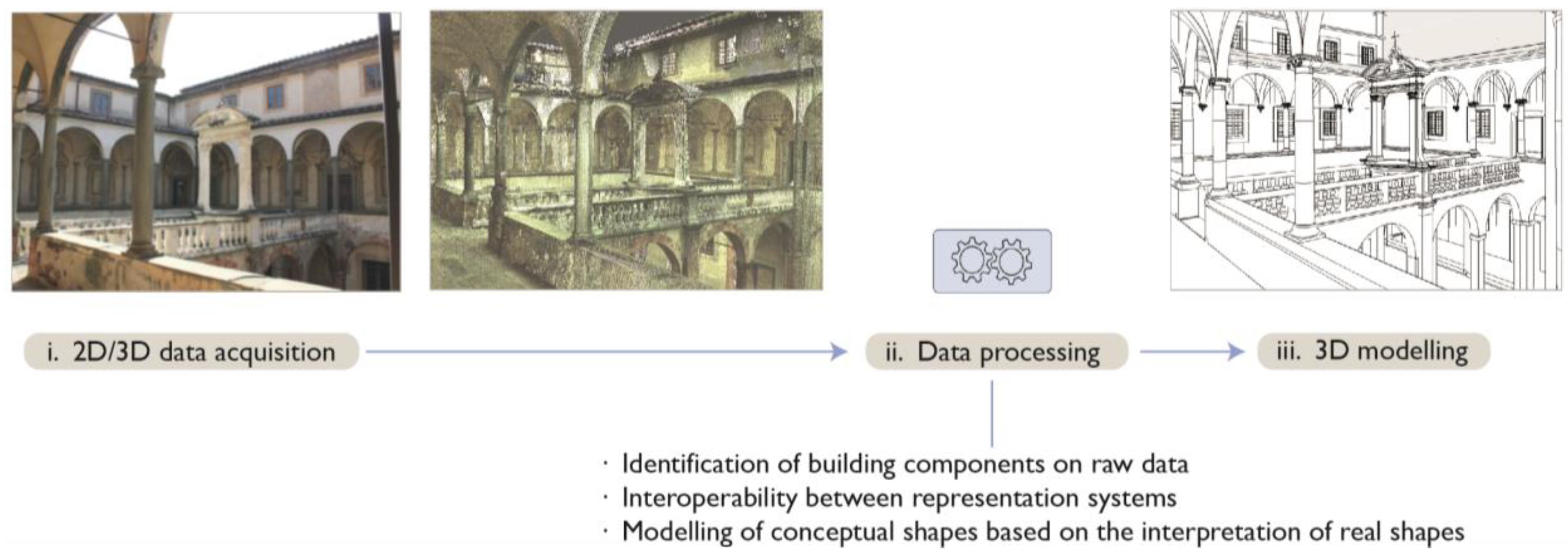
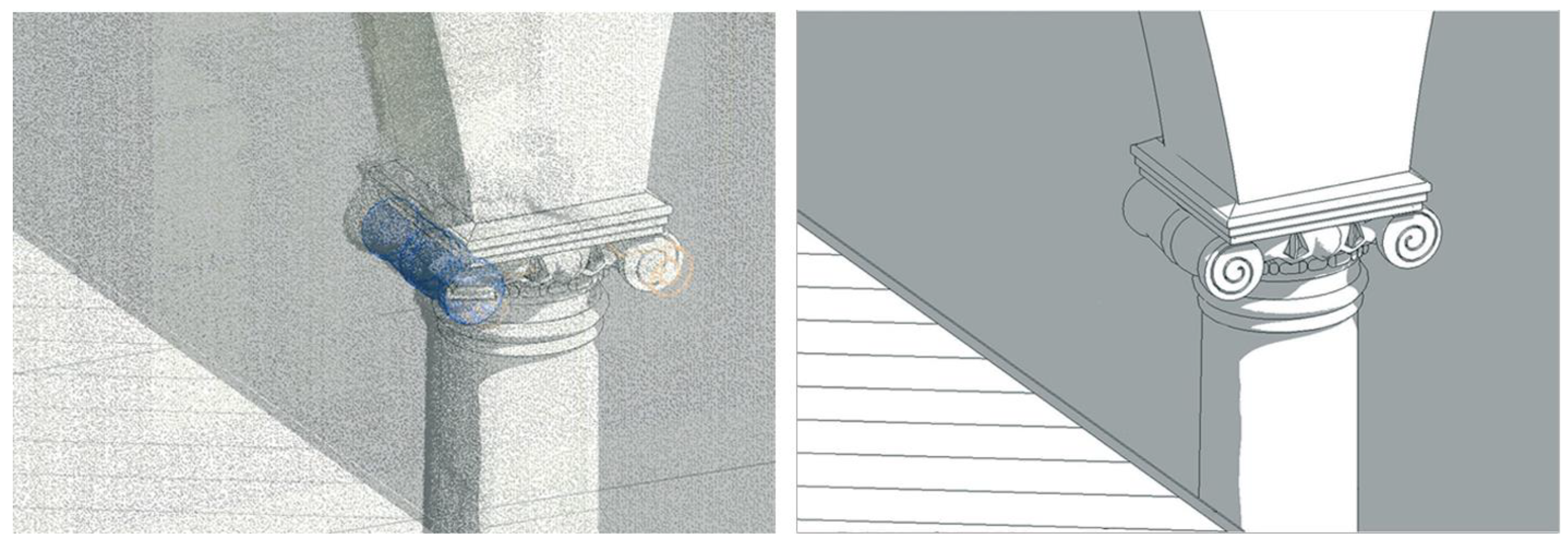
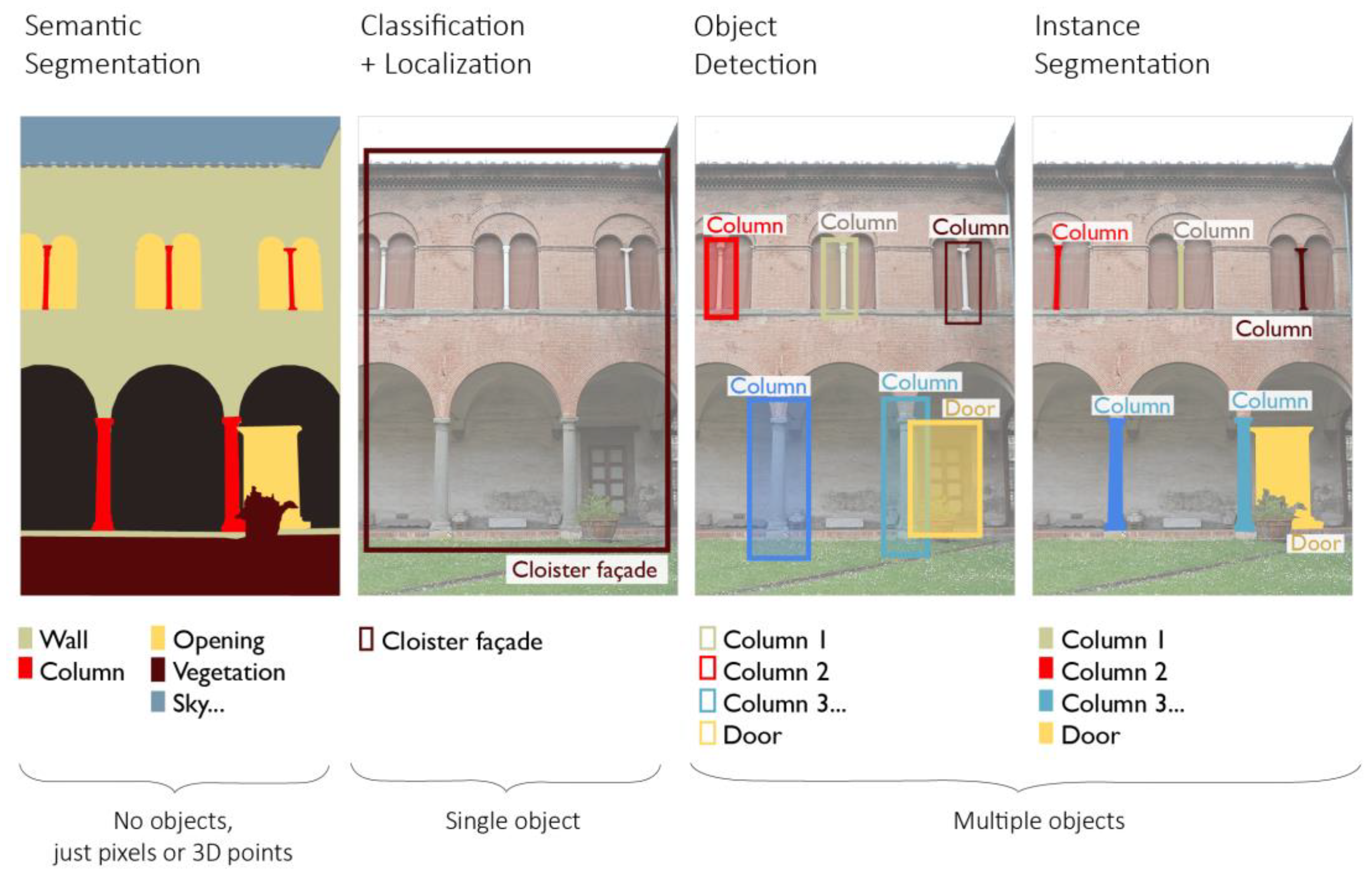
Heritage- or Historic-Building Information Modeling (H-BIM) reconstruction from laser scanning or photogrammetric surveys is a manual, time-consuming, overly subjective process, but the emergence of AI techniques, applied to the realm of existing architectural heritage, is offering new ways to interpret, process and elaborate raw digital surveying data, as point clouds. The proposed methodological approach for higher-level automation in Scan-to-BIM reconstruction is threaded as follows: (i) semantic segmentation via Random Forest and import of annotated data in 3D modeling environment, broken down class by class; (ii) reconstruction of template geometries of classes of architectural elements; (iii) propagation of template reconstructed geometries to all elements belonging to a typological class. Visual Programming Languages (VPLs) and reference to architectural treatises are leveraged for the Scan-to-BIM reconstruction.
1. Introduction
2. Historic-Building Information Modeling and Artificial Intelligence
2.1. State-of-the-Art Scan-to-BIM Reconstruction Processes

2.1.1. Manual Scan-to-BIM Methods

2.1.2. Semi-Automated Scan-to-BIM Methods
2.2. State-of-the-Art AI-Based Semantic Segmentation

References
- Dore, C.; Murphy, M. Semi-automatic techniques for as-built BIM façade modeling of historic buildings. In Proceedings of the 2013 Digital Heritage International Congress (DigitalHeritage), IEEE, Marseille, France, 28 October 2013–1 November 2013; pp. 473–480.
- Murphy, M.; McGovern, E.; Pavia, S. Historic building information modelling (HBIM). Struct. Surv. 2009, 27, 311–327.
- López, F.; Lerones, P.; Llamas, J.; Gómez-García-Bermejo, J.; Zalama, E. A Review of Heritage Building Information Modeling (H-BIM). MTI 2018, 2, 21.
- Pocobelli, D.P.; Boehm, J.; Bryan, P.; Still, J.; Grau-Bové, J. BIM for heritage science: A review. Herit. Sci. 2018, 6, 30.
- Pătrăucean, V.; Armeni, I.; Nahangi, M.; Yeung, J.; Brilakis, I.; Haas, C. State of research in automatic as-built modelling. Adv. Eng. Inform. 2015, 29, 162–171.
- Logothetis, S.; Delinasiou, A.; Stylianidis, E. Building Information Modelling for Cultural Heritage: A review. ISPRS Ann. Photogramm. Remote Sens. Spat. Inf. Sci. 2015, II-5/W3, 177–183.
- Volk, R.; Stengel, J.; Schultmann, F. Building Information Modeling (BIM) for existing buildings—Literature review and future needs. Autom. Constr. 2014, 38, 109–127.
- Hichri, N.; Stefani, C.; De Luca, L.; Veron, P.; Hamon, G. From point cloud to BIM: A survey of existing approaches. Int. Arch. Photogramm. Remote Sens. Spat. Inf. Sci. 2013, XL-5/W2, 343–348.
- Miceli, A.; Morandotti, M.; Parrinello, S. 3D survey and semantic analysis for the documentation of built heritage. The case study of Palazzo Centrale of Pavia University. VITRUVIO Int. J. Archit. Technol. Sustain. 2020, 5, 65.
- Oreni, D.; Brumana, R.; Georgopoulos, A.; Cuca, B. HBIM for conservation and built heritage: Towards a library of vaults and wooden bean floors. ISPRS Ann. Photogramm. Remote Sens. Spat. Inf. Sci. 2013, II-5/W1, 215–221.
- Arayici, Y. Towards building information modelling for existing structures. Struct. Surv. 2008, 26, 210–222.
- Fai, S.; Sydor, M. Building Information Modelling and the documentation of architectural heritage: Between the ‘typical’ and the ‘specific’. In Proceedings of the 2013 Digital Heritage International Congress (DigitalHeritage), Marseille, France, 28 October 2013–1 November 2013; Volume 1, pp. 731–734.
- Bacci, G.; Bertolini, F.; Bevilacqua, M.G.; Caroti, G.; Martínez-Espejo Zaragoza, I.; Martino, M.; Piemonte, A. HBIM methodologies for the architectural restoration. The case of the ex-church of San Quirico all’Olivo in Lucca, Tuscany. Int. Arch. Photogramm. Remote Sens. Spat. Inf. Sci. 2019, XLII-2/W11, 121–126.
- Angulo-Fornos, R.; Castellano-Román, M. HBIM as Support of Preventive Conservation Actions in Heritage Architecture. Experience of the Renaissance Quadrant Façade of the Cathedral of Seville. Appl. Sci. 2020, 10, 2428.
- Barazzetti, L.; Banfi, F.; Brumana, R.; Gusmeroli, G.; Previtali, M.; Schiantarelli, G. Cloud-to-BIM-to-FEM: Structural simulation with accurate historic BIM from laser scans. Simul. Model. Pract. Theory 2015, 57, 71–87.
- Croce, P.; Landi, F.; Puccini, B.; Martino, M.; Maneo, A. Parametric HBIM procedure for the structural evaluation of Heritage masonry buildings. Buildings 2022, 12, 194.
- Pepe, M.; Costantino, D.; Restuccia Garofalo, A. An efficient pipeline to obtain 3D model for HBIM and structural analysis purposes from 3D point clouds. Appl. Sci. 2020, 10, 1235.
- Brumana, R.; Oreni, D.; Cuca, B.; Binda, L.; Condoleo, P.; Triggiani, M. Strategy for integrated surveying techniques finalized to interpretive models in a Byzantine Church, Mesopotam, Albania. Int. J. Archit. Herit. 2014, 8, 886–924.
- Pocobelli, D.P.; Boehm, J.; Bryan, P.; Still, J.; Grau-Bové, J. Building Information Modeling for monitoring and simulation data in heritage buildings. Int. Arch. Photogramm. Remote Sens. Spat. Inf. Sci. 2018, 42, 909–916.
- Martinez Espejo Zaragoza, I.; Caroti, G.; Piemonte, A. The use of image and laser scanner survey archives for cultural heritage 3D modelling and change analysis. ACTA IMEKO 2021, 10, 114.
- Brumana, R.; Oreni, D.; Barazzetti, L.; Cuca, B.; Previtali, M.; Banfi, F. Survey and Scan to BIM Model for the Knowledge of Built Heritage and the Management of Conservation Activities. In Digital Transformation of the Design, Construction and Management Processes of the Built Environment; Daniotti, B., Gianinetto, M., Della Torre, S., Eds.; Springer International Publishing: Cham, Switzerland, 2020; pp. 391–400. ISBN 978-3-030-33570-0.
- Bruno, S.; Musicco, A.; Fatiguso, F.; Dell’Osso, G.R. The Role of 4D Historic Building Information Modelling and Management in the Analysis of Constructive Evolution and Decay Condition within the Refurbishment Process. Int. J. Archit. Herit. 2019, 15, 1250–1266.
- Macher, H.; Landes, T.; Grussenmeyer, P. From Point Clouds to Building Information Models: 3D Semi-Automatic Reconstruction of Indoors of Existing Buildings. Appl. Sci. 2017, 7, 1030.
- Bevilacqua, M.G.; Caroti, G.; Piemonte, A.; Terranova, A.A. Digital Technology and Mechatronic Systems for the Architectural 3D Metric Survey. In Mechatronics for Cultural Heritage and Civil Engineering; Intelligent Systems, Control and Automation: Science and Engineering; Ottaviano, E., Pelliccio, A., Gattulli, V., Eds.; Springer International Publishing: Cham, Switzerland, 2018; Volume 92, pp. 161–180. ISBN 978-3-319-68645-5.
- Fiorucci, M.; Khoroshiltseva, M.; Pontil, M.; Traviglia, A.; Del Bue, A.; James, S. Machine Learning for Cultural Heritage: A Survey. Pattern Recognit. Lett. 2020, 133, 102–108.
- Matrone, F.; Grilli, E.; Martini, M.; Paolanti, M.; Pierdicca, R.; Remondino, F. Comparing Machine and Deep Learning Methods for Large 3D Heritage Semantic Segmentation. IJGI 2020, 9, 535.
- Grilli, E.; Remondino, F. Classification of 3D Digital Heritage. Remote Sens. 2019, 11, 847.
- Rocha, G.; Mateus, L.; Fernández, J.; Ferreira, V. A Scan-to-BIM Methodology Applied to Heritage Buildings. Heritage 2020, 3, 47–67.
- Yang, X.; Koehl, M.; Grussenmeyer, P. Mesh-To-BIM: From segmented mesh elements to BIM model with limited parameters. Int. Arch. Photogramm. Remote Sens. Spat. Inf. Sci. 2018, 42, 1213–1218.
- Bruno, S.; De Fino, M.; Fatiguso, F. Historic Building Information Modelling: Performance assessment for diagnosis-aided information modelling and management. Autom. Constr. 2018, 86, 256–276.
- Previtali, M.; Barazzetti, L.; Brumana, R.; Scaioni, M. Towards automatic indoor reconstruction of cluttered building rooms from point clouds. ISPRS Ann. Photogramm. Remote Sens. Spat. Inf. Sci. 2014, 2, 281–288.
- Bruno, N.; Roncella, R. HBIM for Conservation: A New Proposal for Information Modeling. Remote Sens. 2019, 11, 1751.
- Tommasi, C.; Achille, C. Interoperability matter: Levels of data sharing, starting from a 3D information modeling. Int. Arch. Photogramm. Remote Sens. Spat. Inf. Sci. 2017, XLII-2/W3, 623–630.
- Tang, P.; Huber, D.; Akinci, B.; Lipman, R.; Lytle, A. Automatic reconstruction of as-built building information models from laser-scanned point clouds: A review of related techniques. Autom. Constr. 2010, 19, 829–843.
- Dore, C.; Murphy, M. Current state of the art Historic Building Information Modeling. Int. Arch. Photogramm. Remote Sens. Spat. Inf. Sci. 2017, 42, 185–192.
- Xiong, X.; Adan, A.; Akinci, B.; Huber, D. Automatic creation of semantically rich 3D building models from laser scanner data. Autom. Constr. 2013, 31, 325–337.
- Jung, J.; Hong, S.; Jeong, S.; Kim, S.; Cho, H.; Hong, S.; Heo, J. Productive modeling for development of as-built BIM of existing indoor structures. Autom. Constr. 2014, 42, 68–77.
- Zhang, X. Curvature estimation of 3D point cloud surfaces through the fitting of normal section curvatures. Proc. Asiagraph 2008, 8, 23–26.
- Schnabel, R.; Wahl, R.; Klein, R. Efficient RANSAC for Point-Cloud Shape Detection. Comput. Graph. Forum 2007, 26, 214–226.
- Fischler, M.A.; Bolles, R.C. Random sample consensus: A paradigm for model fitting with applications to image analysis and automated cartography. Commun. ACM 1981, 24, 381–395.
- Hough, P.V.C. Method and Means for Recognizing Complex. Patterns. Patent 3,069,654, 18 December 1962.
- Thomson, C.; Boehm, J. Automatic Geometry Generation from Point Clouds for BIM. Remote Sens. 2015, 7, 11753–11775.
- Bosché, F.; Ahmed, M.; Turkan, Y.; Haas, C.T.; Haas, R. The value of integrating Scan-to-BIM and Scan-vs-BIM techniques for construction monitoring using laser scanning and BIM: The case of cylindrical MEP components. Autom. Constr. 2015, 49, 201–213.
- Wang, Z.; Shi, W.; Akoglu, K.; Kotoula, E.; Yang, Y.; Rushmeier, H. CHER-Ob: A Tool for Shared Analysis and Video Dissemination. J. Comput. Cult. Herit. 2018, 11, 1–22.
- Hong, S.; Jung, J.; Kim, S.; Cho, H.; Lee, J.; Heo, J. Semi-automated approach to indoor mapping for 3D as-built building information modeling. Comput. Environ. Urban Syst. 2015, 51, 34–46.
- Santagati, C.; Lo Turco, M.; Garozzo, R. Reverse information modeling for historic artefacts: Towards the definition of a level of accuracy for ruined heritage. Int. Arch. Photogramm. Remote Sens. Spat. Inf. Sci. 2018, 42, 1007–1014.
- Yang, X.; Lu, Y.-C.; Murtiyoso, A.; Koehl, M.; Grussenmeyer, P. HBIM Modeling from the Surface Mesh and Its Extended Capability of Knowledge Representation. IJGI 2019, 8, 301.
- Rodríguez-Moreno, C.; Reinoso-Gordo, J.F.; Rivas-López, E.; Gómez-Blanco, A.; Ariza-López, F.J.; Ariza-López, I. From point cloud to BIM: An integrated workflow for documentation, research and modelling of architectural heritage. Surv. Rev. 2018, 50, 212–231.
- Quattrini, R.; Battini, C.; Mammoli, R. HBIM TO VR. Semantic awareness and data enrichment interoperability for parametric libraries of historical architecture. Int. Arch. Photogramm. Remote Sens. Spat. Inf. Sci. 2018, 42, 937–943.
- Baik, A. From point cloud to Jeddah Heritage BIM Nasif Historical House—Case study. Digit. Appl. Archaeol. Cult. Herit. 2017, 4, 1–18.
- Fai, S.; Rafeiro, J. Establishing an appropriate Level of Detail (LoD) for a Building Information Model (BIM)—West Block, Parliament Hill, Ottawa, Canada. ISPRS Ann. Photogramm. Remote Sens. Spat. Inf. Sci. 2014, 2, 123–130.
- De Luca, L.; Véron, P.; Florenzano, M. A generic formalism for the semantic modeling and representation of architectural elements. Vis. Comput. 2007, 23, 181–205.
- Murphy, M.; McGovern, E.; Pavia, S. Historic Building Information Modelling—Adding intelligence to laser and image based surveys of European classical architecture. ISPRS J. Photogramm. Remote Sens. 2013, 14, 89–102.
- Tommasi, C.; Achille, C.; Fassi, F. From point cloud to BIM: A modelling challenge in the Cultural Heritage field. Int. Arch. Photogramm. Remote Sens. Spat. Inf. Sci. 2016, 41, 429–436.
- Andriasyan, M.; Moyano, J.; Nieto-Julián, J.E.; Antón, D. From Point Cloud Data to Building Information Modelling: An Automatic Parametric Workflow for Heritage. Remote Sens. 2020, 12, 1094.
- Capone, M.; Lanzara, E. Scan-to-BIM vs. 3D ideal modela HBIM: Parametric tools to study domes geometry. Int. Arch. Photogramm. Remote Sens. Spat. Inf. Sci. 2019, 42, 219–226.
- Kelly, G. A survey of procedural techniques for city generation. ITB J. 2006, 14, 342–351.
- Pierdicca, R.; Paolanti, M.; Matrone, F.; Martini, M.; Morbidoni, C.; Malinverni, E.S.; Frontoni, E.; Lingua, A.M. Point Cloud Semantic Segmentation Using a Deep Learning Framework for Cultural Heritage. Remote Sens. 2020, 12, 1005.
- Paumard, M.-M.; Picard, D.; Tabia, H. Deepzzle: Solving Visual Jigsaw Puzzles with Deep Learning and Shortest Path Optimization. IEEE Trans. Image Process. 2020, 29, 3569–3581.
- Ibrahim, Y.; Nagy, B.; Benedek, C. Deep Learning-Based Masonry Wall Image Analysis. Remote Sens. 2020, 12, 3918.
- Varinlioglu, G.; Balaban, O. Artificial Intelligence in Architectural Heritage Research: Simulating Networks of Caravanserais through Machine Learning; The Routledge Companion to Artificial Intelligence in Architecture; Basu, P., Ed.; Routledge: Abingdon-on-Thames, UK, 2021; ISBN 978-0-367-42458-9.
- Korc, F.; Forstner, W. eTRIMS Image Database for Interpreting Images of Man-Made Scenes. Comput. Sci. 2009, 12, 62918340.
- Manfredi, M.; Grana, C.; Cucchiara, R. Automatic Single-Image People Segmentation and Removal for Cultural Heritage Imaging. In New Trends in Image Analysis and Processing—ICIAP 2013; Petrosino, A., Maddalena, L., Pala, P., Eds.; Springer: Berlin/Heidelberg, Germany, 2013; pp. 188–197.
- Grilli, E.; Dininno, D.; Petrucci, G.; Remondino, F. From 2D to 3D supervised segmentation and classification for Cultural Heritage applications. Int. Arch. Photogramm. Remote Sens. Spat. Inf. Sci. 2018, 42, 399–406.
- Musicco, A.; Galantucci, R.A.; Bruno, S.; Verdoscia, C.; Fatiguso, F. Automatic point cloud segmentation for the detection of alterations on historical buildings through an unsupervised and clustering-based Machine Learning approach. ISPRS Ann. Photogramm. Remote Sens. Spat. Inf. Sci. 2021, 2, 129–136.
- Bassier, M.; Yousefzadeh, M.; Vergauwen, M. Comparison of 2D and 3D wall reconstruction algorithms from point cloud data for as-built BIM. ITcon 2020, 25, 173–192.
- El Kadi, K.A. Automatic Extraction of Facade Details of Heritage Building Using Terrestrial Laser Scanning Data. J. Archit. Eng. Technol. 2014, 3, 2.
- Morbidoni, C.; Pierdicca, R.; Paolanti, M.; Quattrini, R.; Mammoli, R. Learning from synthetic point cloud data for historical buildings semantic segmentation. J. Comput. Cult. Herit. 2020, 13, 1–16.
- Grilli, E.; Farella, E.M.; Torresani, A.; Remondino, F. Geometric features analysis for the classification of Cultural Heritage point clouds. Int. Arch. Photogramm. Remote Sens. Spat. Inf. Sci. 2019, 42, 541–548.
- Malinverni, E.S.; Mariano, F.; Di Stefano, F.; Petetta, L.; Onori, F. Modeling in HBIM to document materials decay by a thematic mapping to manage the Cultural Heritage: The case of Chiesa della Pietà in Fermo. Int. Arch. Photogramm. Remote Sens. Spat. Inf. Sci. 2019, 42, 777–784.
- Weinmann, M. Reconstruction and Analysis of 3D Scenes; Springer International Publishing: Cham, Switzerland, 2016; ISBN 978-3-319-29244-1.
- Özdemir, E.; Remondino, F.; Golkar, A. Aerial point cloud classification with deep learning and machine learning algorithms. Int. Arch. Photogramm. Remote Sens. Spat. Inf. Sci. 2019, XLII-4/W18, 843–849.
- Breiman, L. Ramdom forests. Mach. Learn. 2001, 45, 5–32.


