Your browser does not fully support modern features. Please upgrade for a smoother experience.
Submitted Successfully!
 +1 credit
Thank you for your contribution! You can also upload a video entry or images related to this topic.
For video creation, please contact our Academic Video Service.
| Version | Summary | Created by | Modification | Content Size | Created at | Operation |
|---|---|---|---|---|---|---|
| 1 | Kalle Konttinen | -- | 1293 | 2023-11-30 09:43:26 | | | |
| 2 | Catherine Yang | Meta information modification | 1293 | 2023-12-01 02:21:11 | | |
Video Upload Options
We provide professional Academic Video Service to translate complex research into visually appealing presentations. Would you like to try it?
Cite
If you have any further questions, please contact Encyclopedia Editorial Office.
Balawejder, M.; Warchoł, A.; Konttinen, K. Energy Efficiency in Land Consolidation. Encyclopedia. Available online: https://encyclopedia.pub/entry/52221 (accessed on 22 June 2026).
Balawejder M, Warchoł A, Konttinen K. Energy Efficiency in Land Consolidation. Encyclopedia. Available at: https://encyclopedia.pub/entry/52221. Accessed June 22, 2026.
Balawejder, Monika, Artur Warchoł, Kalle Konttinen. "Energy Efficiency in Land Consolidation" Encyclopedia, https://encyclopedia.pub/entry/52221 (accessed June 22, 2026).
Balawejder, M., Warchoł, A., & Konttinen, K. (2023, November 30). Energy Efficiency in Land Consolidation. In Encyclopedia. https://encyclopedia.pub/entry/52221
Balawejder, Monika, et al. "Energy Efficiency in Land Consolidation." Encyclopedia. Web. 30 November, 2023.
Copy Citation
Land consolidation in rural areas is greatly influenced by a number of social, agricultural, and economic factors. They extend the time and complicate activities related to the implementation of this project. Land consolidation is a huge investment, requiring a good and up-to-date map.
land consolidation
open geospatial datasets
energy efficiency
1. Introduction
Agriculture is one of the least digitized human activity industries. The higher the level of digitisation, the easier it is to monitor production processes and improve activity indicators, including efficiency [1][2][3]. Food production and agriculture have an important role in maintaining biodiversity and rural landscapes. In addition to its positive effects, agriculture also has adverse environmental impacts on soil, water systems, and the atmosphere [4]. There are a number of factors in agricultural production that farmers have no control over on a macro scale (e.g., country or region) [5], such as temperature or rainfall. Along with soil quality, they are key parameters affecting the efficiency of agricultural production. In order to increase efficiency/profitability, one can either focus on raising yields or lowering production costs. In the first approach, the focus will be on adequate soil moisture, temperature regulation, and proper soil fertilisation. However, each of these activities increases energy requirements. On the other hand, production costs can be minimized by optimizing the shape of farms and the shape of individual plots themselves, which can be achieved by implementing an agricultural land consolidation project. In the land consolidation project, properly designed agricultural transport roads will change the number of kilometers that must be traveled by agricultural machinery. Such an action directly translates into a change in the amount of fuel needed to operate the farm, thus increasing energy efficiency in agricultural operations and reducing the carbon footprint [6][7][8][9].
2. Geostaptial Datasets and Information
Modern geomatics technologies are used in various tasks related to mapping the natural environment. LiDAR laser scanning can be used both for inventory measurements, describing reality as presented in papers [10][11], as well as for long-term activities, i.e., monitoring [12][13]. In environmental issues, there is often a need to use multi-source data, examples of which can be found in papers [14][15][16][17]. Data integration also occurs in the area of cultural heritage, examples of which can be found in papers [18][19]. The aforementioned LiDAR technology is also very often used in surveying for the acquisition of geometrical source data for cultural heritage [20][21]. An extension of the above-mentioned documentation are BIM/HBIM models, examples of which can be found in [22]. Qualitative aspects in [23], accuracy aspects in [24] or the image-based approach in [25].
The geospatial data obtained in this way are the basis for spatial management [26][27], or cultural heritage [28][29].
An important aspect of having and using geospatial data are also making it available to other entities, scientific units, or the general public. For this reason, publications [30][31][32][33] seem relevant.
The utilitarian aspect of the research should not be overlooked either. In this context, it is worth citing works that could not have been produced without linking the research carried out to the space. These are: noise [34], land consolidation [35], cadastral works [36][37], displacement [38], air quality [39], land use [40], or building monitoring [41].
3. Land Consolidation
The level of development of consolidation work in two countries—Poland and Finland—is presented below. The use of digital geospatial data for the planning and implementation of consolidation work were taken as an indicator of the level of development. Due to the history of implemented projects in Poland, where the use of digital geospatial data are lower, the assessment of the effects of consolidation is mainly based on geometric indicators [42][43][44]. In contrast, in Finland, where the history of consolidation work is more than 260 years old, areas are being consolidated once again, assessing the effect mainly in terms of economics.
Almost 100 years of land consolidation development in rural areas that took place in Poland show the multi-criteria nature of this procedure [45]. EU funding helps to improve, among others, the area structure of agricultural land in the European Union (EU) countries [46][47][48]. The agricultural area in EU countries covers almost half of the land of the whole country [49]. In 2015, agricultural land was estimated to cover 42% of all EU land area [50].
Figure 1 shows the agricultural area as a percentage of the total area in individual EU countries. Blue columns: agricultural area in% (scale on the left side of the chart) and size of agricultural area in 1000 hectares—red dots (scale on the right side). The agricultural area is the area that may be included in land consolidation work.
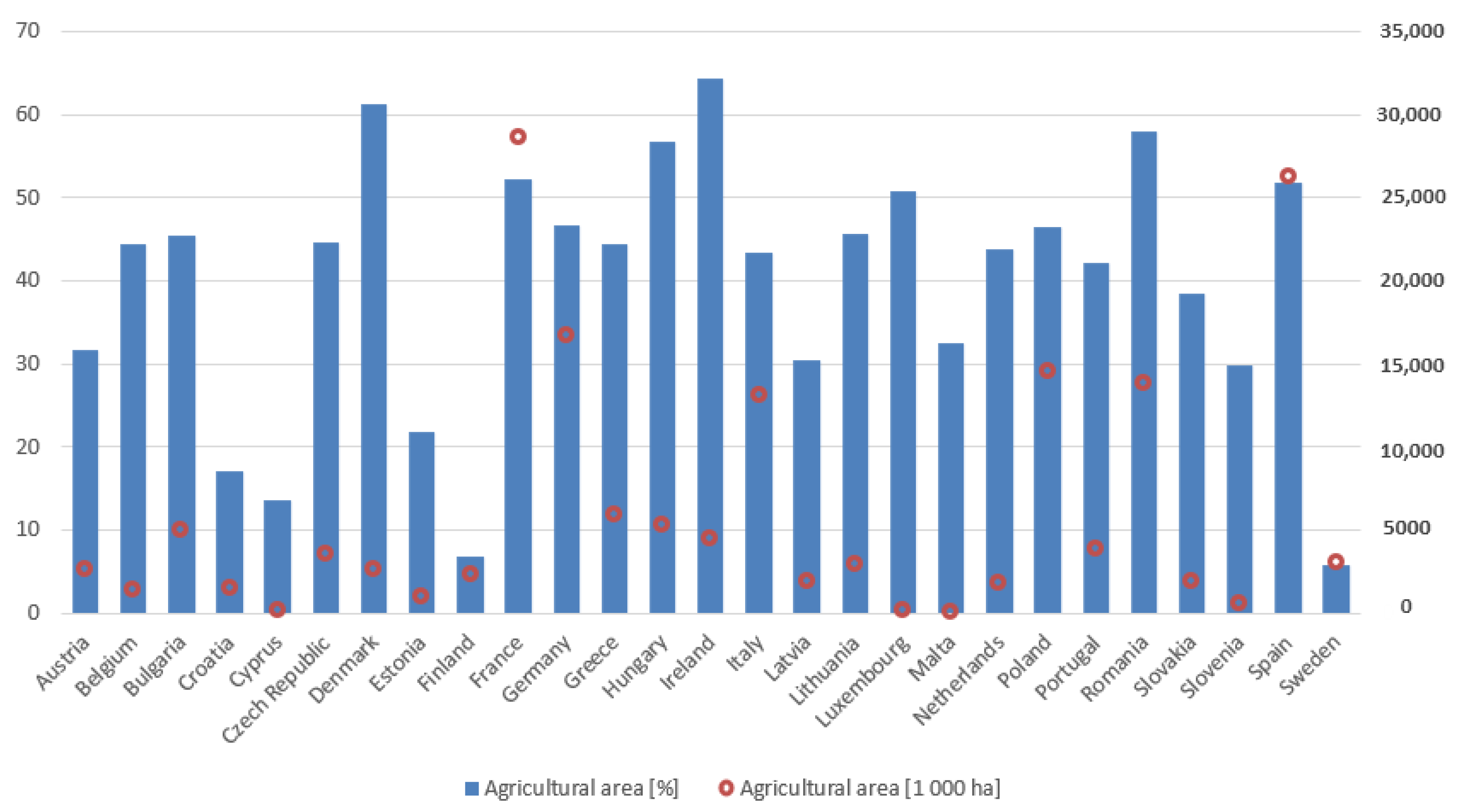
Figure 1. Agricultural area from the total area in individual EU countries. Source: own study based on data from the FAO Estimate, 2019 [51].
Poland takes 9th place out of 27 EU member states, where 1st place is the largest percentage of agricultural area in relation to the country’s area. Notice that Finland and Sweden have a low percentage. For example, Finland has the same amount of agricultural land as Denmark. Because Finland and Sweden are large countries with large amounts of forests, their percentage here is low. Also, agricultural areas both in Sweden and Finland are concentrated in the southern parts, where municipal or provincial-level percentages can be high.
Additionally, the high fragmentation of the agricultural area in Poland makes us one of the leading countries that urgently needs land consolidation in rural areas [43][52][53][54][55]. The problem of excessive land fragmentation affects many countries. One can read in the literature that it occurs, among others, in Bulgaria [56][57], in the Republic of Belarus [58], in Cyprus [59], in the Czech Republic [60], in Estonia [61], in Finland [62][63], in Hungary [64], in Latvia [65], in Lithuania [66], in Slovakia [67], in Spain [68], in The Netherlands [69][70], and in Ukraine [71].
In Poland, since 2008, the number of cadastral plots has been systematically increasing. Over the past 12 years, the number of cadastral plots has increased by over 3 million. The number of cadastral plots is systematically increasing as a result of dividing real estate. In Finland, agricultural plots are only a small minority of cadastral plots; this number does not show fragmentation at agricultural plots. In Finland, they follow agricultural administration IACS-systems information en masse to show real cultivated parcels (regardless of ownership).
4. The Impact of Land Consolidation on Energy Efficiency
The land consolidation processes in Poland focus not only on the geometric and location aspects of the farm but also, to a greater extent, on translating these into economic and ecological aspects. Such activities are in line with the directions of the European Green Deal and will certainly translate into reduced energy consumption and a lower carbon footprint [8][72]. Authors [73] suggest that moderate changes in food diets and land use in Finland can reduce GHG emissions from agriculture by more than 40% by 2050. In the period 2021–2030, the collective target of EU Member States is to reduce greenhouse gas emissions by 30% from the 2005 level by 2030 [4].
Better road planning in the land consolidation project will result in reduced agricultural production costs, lower fuel consumption, and a smaller carbon footprint. The basic elements of transport infrastructure are agricultural roads (access to fields). Hence, the high share of agricultural transport costs can be reduced through an appropriate system of these [74] roads. Each newly separated cadastral plot in the land consolidation in rural areas must have access to a public road. Consequently, the road infrastructure in a land consolidation project is extremely important. The road network density indicator is often mentioned by communes as the most important consolidation effect [45]. A very important effect of land consolidation in rural areas is post-merger management, including the arrangement and modernisation of “agricultural transport roads,” which provide access to each registration plot [45]. The paper [74] describes the influence of the distribution—the arrangement of fields in relation to the economic center—on the distance and the expenditure incurred in internal transport. The conclusions from these studies are as follows: Fuel consumption costs are 92.25% [74] lower after consolidating land and arranging all cadastral plots around the farm.
References
- Zawilińska, B.; Brańka, P.; Majewski, K.; Semczuk, M. National Parks—Areas of Economic Development or Stagnation? Evidence from Poland. Sustainability 2021, 13, 11351.
- Telega, A.; Bieda, A. Analizy Stopnia Dopasowania Sposobu Użytkowania Ziemi, Jako Narzędzie Zarządzania Konfliktami Przestrzennymi. Infrastrukt. I Ekol. Teren. Wiej.-Infrastruct. Ecol. Rural AREAS 2015, IV, 1007–1020.
- Li, M.; Milojevic, M.; Gura, D.; Gura, D.; Li, M. Development of Methodology for Evaluating Sustainable Rural Development. Environ. Dev. Sustain. 2023, 1–21.
- Niemi, J.; Väre, M. Agriculture and Food Sector in Finland 2019; Luke Natural Resources Institute Finland: Helsinki, Finland, 2019; ISBN 978-952-326-770-1.
- Surówka, M.; Popławski, Ł.; Fidlerová, H. Technical Infrastructure as an Element of Sustainable Development of Rural Regions in Małopolskie Voivodeship in Poland and Trnava Region in Slovakia. Agriculture 2021, 11, 141.
- Manavbaşı, D.; Polat, H.E. Determining the Effects of Land Consolidation on Fuel Consumption and Carbon Dioxide Emissions in Rural Area. J. Agric. Sci. 2012, 18, 157–165.
- Ertunç, E.; Janus, J.; Uyan, M. Prioritization of Land Consolidation Projects Using the Multi-Criteria Best-Worst Method: A Case Study from Poland. Environ. Monit. Assess. 2023, 195, 1045.
- Janus, J.; Ertunç, E. Impact of Land Consolidation on Agricultural Decarbonization: Estimation of Changes in Carbon Dioxide Emissions Due to Farm Transport. Sci. Total Environ. 2023, 873, 162391.
- Ramírez del Palacio, Ó.; Hernández-Navarro, S.; Sánchez-Sastre, L.F.; Fernández-Coppel, I.A.; Pando-Fernández, V. Assessment of Land Consolidation Processes from an Environmental Approach: Considerations Related to the Type of Intervention and the Structure of Farms. Agronomy 2022, 12, 1424.
- Chiappini, S.; Pierdicca, R.; Malandra, F.; Tonelli, E.; Malinverni, E.S.; Urbinati, C.; Vitali, A. Comparing Mobile Laser Scanner and Manual Measurements for Dendrometric Variables Estimation in a Black Pine (Pinus Nigra Arn.) Plantation. Comput. Electron. Agric. 2022, 198, 107069.
- Wężyk, P.; Hawryło, P.; Szostak, M.; Zięba-Kulawik, K.; Winczek, M.; Siedlarczyk, E.; Kurzawiński, A.; Rydzyk, J.; Kmiecik, J.; Gilewski, W.; et al. Using LiDAR Point Clouds in Determination of the Scots Pine Stands Spatial Structure Meaning in the Conservation of Lichen Communities in “Bory Tucholskie” National Park. Arch. Photogramm. Cartogr. Remote Sens. 2019, 31, 85–103.
- Zięba-Kulawik, K. Rola Wskaźników Krajobrazowych w Monitorowaniu Przemian Lasów Miejskich z Wykorzystaniem Technologii Geoinformacyjnych; University of Agriculture in Krakow: Krakow, Poland, 2022.
- Krawczyk, K. Influence of Reference Stations on the Stability of the Geodetic Control Network during Deformation Determination in the Area of Kadzielnia in Kielce. Rep. Geod. Geoinform. 2023, 115, 19–26.
- Balestra, M.; Chiappini, S.; Vitali, A.; Tonelli, E.; Malandra, F.; Galli, A.; Urbinati, C.; Malinverni, E.S.; Pierdicca, R. Integration of Geomatic Techniques for The 3D Representation and Monitoring of a Veteran Chestnut Tree. In Proceedings of the International Archives of the Photogrammetry, Remote Sensing and Spatial Information Sciences-ISPRS Archives, Krakow, Poland, 23–24 October 2022; Volume 43.
- Hajdukiewicz, M. Use of Archival Aerial Photos and Images Acquired Using UAV to Reconstruct the Changes of Annual Load of the Suburban Landfill: Case Study of Promnik, Poland. Energies 2022, 16, 181.
- Warchoł, A.; Szwed, P.; Wężyk, P. Integration of Technology of Airborne, Mobile, and Terrestrial Laser Scanning in the Process of Inventory Urban Vegetation in Selected Parts of Kraków. In Proceedings of the Pokrycie Terenu I Przewietrzanie Krakowa, Krakow, Poland, 20 October 2016; pp. 67–79.
- Bakula, K.; Lejzerowicz, A.; Pilarska-Mazurek, M.; Ostrowski, W.; Górka, J.; Biernat, P.; Czernic, P.; Zalegowski, K.; Kleszczewska, K.; Wezka, K.; et al. Sensor Integration and Application of Low-Sized Mobile Mapping Platform Equipped with Lidar, Gpr and Photogrammetric Sensors. In Proceedings of the International Archives of the Photogrammetry, Remote Sensing and Spatial Information Sciences-ISPRS Archives, Krakow, Poland, 23–24 October 2022; Volume 43, pp. 167–172.
- Di Stefano, F.; Sanità, M.; Malinverni, E.S.; Doti, G. Geomatic Technologies to Valorize Historical Watermills. Int. Arch. Photogramm. Remote Sens. Spat. Inf. Sci. 2023, 48, 511–518.
- Sobura, S.; Bacharz, K.; Granek, G. Analysis of Two-Option Integration of Unmanned Aerial Vehicle and Terrestrial Laser Scanning Data for Historical Architecture Inventory. Geod. Cartogr. 2023, 49, 76–87.
- Herrero-Tejedor, T.R.; Maté-González, M.Á.; Pérez-Martín, E.; López-Cuervo, S.; López de Herrera, J.; Sánchez-Aparicio, L.J.; Villanueva Llauradó, P. Documentation and Virtualisation of Vernacular Cultural Heritage: The Case of Underground Wine Cellars in Atauta (Soria). Heritage 2023, 6, 5130–5150.
- Gawronek, P.; Makuch, M.; Mitka, B.; Bożek, P.; Klapa, P. 3D Scanning of the Historical Underground of Benedictine Abbey in Tyniec (POLAND). In Proceedings of the International Multidisciplinary Scientific GeoConference: SGEM-Section Geodesy and Mine Surveying, Albena, Bulgaria, 29 June–5 July 2017.
- Warchoł, A.; Lęcznar, J. Gęstość Naziemnych Chmur Punktów LiDAR w Kontekście Modelowania BIM. In Pozyskiwanie Danych Geodezyjnych dla Potrzeb Gospodarowania Przestrzenią Regionu Świętokrzyskiego; Wolski, B., Cienciała, A., Eds.; Wydawnictwo Politechniki Świętokrzyskiej: Kielce, Poland, 2022; pp. 77–99.
- Błaszczak-Bąk, W.; Suchocki, C.; Mrówczyńska, M. Optimization of Point Clouds for 3D Bas-Relief Modeling. Autom. Constr. 2022, 140, 104352.
- Skrzypczak, I.; Oleniacz, G.; Leśniak, A.; Zima, K.; Mrówczyńska, M.; Kazak, J.K. Scan-to-BIM Method in Construction: Assessment of the 3D Buildings Model Accuracy in Terms Inventory Measurements. Build. Res. Inf. 2022, 50, 859–880.
- Kontrimovicius, R.; Juszczyk, M.; Leśniak, A.; Ustinovichius, L.; Miedziałkowski, C. Photogrammetry-Based Approach for Collecting and Processing Information about an Existing Building. Bull. Polish Acad. Sci. Tech. Sci. 2023, 71, 144453.
- Karabin, M.; Bakuła, K.; Łuczyński, R. Verification of the Geometrical Representation of Buildings in Cadastre Using UAV Photogrammetry. Geomatics Environ. Eng. 2021, 15, 81–99.
- Medolińska, K.; Gołȩbiowska, I.; Karsznia, I. Local GIS: Development and Assessment of the Geoportal for Local Governments and Local Communities. Case Study of a Small Town in Poland. Misc. Geogr. 2017, 21, 160–167.
- Abate, D.; Agapiou, A.; Toumbas, K.; Lampropoulos, A.; Petrides, K.; Pierdicca, R.; Paolanti, M.; Di Stefano, F.; Felicetti, A.; Malinverni, E.S.; et al. Artificial Intelligence to Fight Illicit Trafficking of Cultural Property. Int. Arch. Photogramm. Remote Sens. Spat. Inf. Sci. 2023, 48, 3–10.
- Malinverni, E.S.; Chiappini, S.; Pierdicca, R. A Geodatabase for Multisource Data Management Applied to Cultural Heritage: The Case Study of Villa Buonaccorsi’s Historical Garden. In Proceedings of the ISPRS Annals of the Photogrammetry, Remote Sensing and Spatial Information Sciences, Milan, Italy, 8–10 May 2019; Volume 42.
- Quattrini, R.; Pierdicca, R.; Morbidoni, C.; Malinverni, E.S. Conservation-Oriented Hbim. The Bimexplorer Web Tool. WG HBIM for Management and Maintenance. Int. Arch. Photogramm. Remote Sens. Spat. Inf. Sci. 2017, XLII, 275–283.
- Vasic, I.; Pauls, A.; Mancini, A.; Quattrini, R.; Pierdicca, R.; Angeloni, R.; Malinverni, E.S.; Frontoni, E.; Clini, P.; Vasic, B. Virtualization and Vice Versa: A New Procedural Model of the Reverse Virtualization for the User Behavior Tracking in the Virtual Museums. In Proceedings of the Lecture Notes in Computer Science (including subseries Lecture Notes in Artificial Intelligence and Lecture Notes in Bioinformatics), Lecce, Italy, 6–8 July 2022; Volume 13446 LNCS.
- Pierdicca, R.; Mulliri, M.; Lucesoli, M.; Piccinini, F.; Malinverni, E.S. Geomatics Meets XR: A Brief Overview of the Synergy Between Geospatial Data and Augmented Visualization. In Proceedings of the Lecture Notes in Computer Science (including subseries Lecture Notes in Artificial Intelligence and Lecture Notes in Bioinformatics), Lecce, Italy, 6–8 July 2022; Volume 13446 LNCS.
- Iosifescu-Enescu, I.; Matthys, C.; Gkonos, C.; Iosifescu-Enescu, C.M.; Hurni, L. Cloud-Based Architectures for Auto-Scalable Web Geoportals towards the Cloudification of the GeoVITe Swiss Academic Geoportal. ISPRS Int. J. Geo-Inf. 2017, 6, 192.
- Szopińska, K.; Balawejder, M.; Warchoł, A. National Legal Regulations and Location of Noise Barriers along the Polish Highway. Transp. Res. Part D Transp. Environ. 2022, 109, 103359.
- Warchoł, A.; Balawejder, M. The Use of Orthophotomaps to Verify the Network of Agricultural Transport Roads in the Land Consolidation Project. In Proceedings of the FIG Congress 2022 Volunteering for the Future-Geospatial Excellence for A Better Living, Warsaw, Poland, 11–15 September 2022.
- Femenia-Ribera, C.; Mora-Navarro, G.; Pérez, L.J.S. Evaluating the Use of Old Cadastral Maps. Land Use Policy 2022, 114, 105984.
- Kurczynski, Z.; Bakuła, K.; Karabin, M.; Kowalczyk, M.; Markiewicz, J.S.; Ostrowski, W.; Podlasiak, P.; Zawieska, D. The possibility of using images obtained from the uas in cadastral works. Int. Arch. Photogramm. Remote Sens. Spat. Inf. Sci. 2016, XLI-B1, 909–915.
- Kuras, P.; Ortyl, Ł.; Owerko, T. Empirical SNR-Based Model of the Displacement Accuracy for Ground-Based Radar Measurements. ISPRS J. Photogramm. Remote Sens. 2022, 194, 181–194.
- Szopińska, K.; Cienciała, A.; Bieda, A.; Kwiecień, J.; Kulesza, Ł.; Parzych, P. Verification of the Perception of the Local Community Concerning Air Quality Using ADMS-Roads Modeling. Int. J. Environ. Res. Public Health 2022, 19, 908.
- Ogryzek, M.; Podawca, K.; Cienciała, A. Geospatial Tools in the Analyses of Land Use in the Perspective of the Accessibility of Selected Educational Services in Poland. Land Use Policy 2022, 122, 106373.
- Szojda, L.; Kapusta, Ł. Evaluation of the Elastic Model of a Building on a Curved Mining Ground Based on the Results of Geodetic Monitoring. Arch. Min. Sci. 2020, 65, 213–224.
- Balawejder, M.; Leń, P. The Realization of Complex Work of Consolidation and Exchange of Land in the Villages Divided by a Highway. Geomatics Environ. Eng. 2016, 10, 27.
- Stręk, Ż.; Noga, K. Method of Delimiting the Spatial Structure of Villages for the Purposes of Land Consolidation and Exchange. Remote Sens. 2019, 11, 1268.
- Woch, F.; Janus, J.; Syp, A.M.A. Metody Oceny Prac Scaleniowych (Methods of Evaluation of Consolidation Works); IUNG: Puławy, Polan, 2018.
- Balawejder, M.; Matkowska, K.; Rymarczyk, E. Effects of Land Consolidation in Southern Poland. Acta Sci. Pol. Adm. Locorum 2021, 20, 269–282.
- Buśko, M.; Zyga, J.; Hudecová, Ľ.; Kyseľ, P.; Balawejder, M.; Apollo, M. Active Collection of Data in the Real Estate Cadastre in Systems with a Different Pedigree and a Different Way of Building Development: Learning from Poland and Slovakia. Sustainability 2022, 14, 15046.
- Pawlikowska, E.; Popek, P.; Bieda, A.; Moteva; Stoeva, A. Analysis of the Legal Methods of Agricultural Land Protection in Central Europe On the Example of Poland and Bulgaria. Real Estate Manag. Valuat. 2017, 25, 58–71.
- Bieda, A.; Jasinska, E.; Preweda, E. Surveying Protection of Agricultural Land in Poland. In Proceedings of the The 9th International Conference “Environmental Engineering”, Vilnius, Lithuania, 22–23 May 2014.
- Klimach, A.; Dawidowicz, A.; Dudzińska, M.; Źróbek, R. An Evaluation of the Informative Usefulness of the Land Administration System for the Agricultural Land Sales Control System in Poland. J. Spat. Sci. 2020, 65, 419–443.
- Perpiña Castillo, C.; Kavalov, B.; Diogo, V.J.-C.C.; Batista e Silva, F.; Baranzelli, C.L.C. Trends in the Eu Agricultural Land within 2015-2030; JRC113717; European Commission: Ispra, Italy, 2018.
- Available online: http://www.fao.org/countryprofiles/index/en/?lang=en&iso3=POL (accessed on 10 October 2023).
- Cienciała, A.; Sobura, S.; Sobolewska-Mikulska, K. Optimising Land Consolidation by Implementing UAV Technology. Sustainability 2022, 14, 4412.
- Janus, J.; Taszakowski, J. Spatial Differentiation of Indicators Presenting Selected Barriers in the Productivity of Agricultural Areas: A Regional Approach to Setting Land Consolidation Priorities. Ecol. Indic. 2018, 93, 718–729.
- Janus, J. Measuring Land Fragmentation Considering the Shape of Transportation Network: A Method to Increase the Accuracy of Modeling the Spatial Structure of Agriculture with Case Study in Poland. Comput. Electron. Agric. 2018, 148, 259–271.
- Noga, K.; Balawejder, M.; Matkowska, K. Dimensions of Destruction of Road Network Providing Access to Cadastral Parcels Resulting from Motorway Construction. Geomatics Environ. Eng. 2017, 11, 65.
- Di Falco, S.; Penov, I.; Aleksiev, A.; van Rensburg, T.M. Agrobiodiversity, Farm Profits and Land Fragmentation: Evidence from Bulgaria. Land Use Policy 2010, 27, 763–771.
- Moteva, M. Legal Conditions and Data Provision for Land Property Exchange in the Processes of Land Consolidation and Land Compensation in Bulgaria. Geomat. Environ. Eng. 2020, 14, 59–71.
- Hrybau, A.; Hrydziushka, A.; Napiórkowska-Baryła, A. Current Problems and Challenges of Agriculture in the Republic of Belarus. Acta Sci. Pol. Adm. Locorum 2022, 21, 105–114.
- Demetriou, D. The Assessment of Land Valuation in Land Consolidation Schemes: The Need for a New Land Valuation Framework. Land Use Policy 2016, 54, 487–498.
- Sklenicka, P. Classification of Farmland Ownership Fragmentation as a Cause of Land Degradation: A Review on Typology, Consequences, and Remedies. Land Use Policy 2016, 57, 694–701.
- Jürgenson, E. Land Reform, Land Fragmentation and Perspectives for Future Land Consolidation in Estonia. Land Use Policy 2016, 57, 34–43.
- Hentunen, H.; Konttinen, K. Surveying the Regional Need for Land Consolidations from GIS Information in Finland. In Proceedings of the FIG Congress, FIG Congress 2022, Warsaw, Poland, 11–15 September 2022; p. 11374.
- Vitikainen, A. An Overview of Land Consolidation in Europe. Nord. J. Surv. Real Estate Res. 2004, 1, 25–44.
- Cegielska, K.; Noszczyk, T.; Kukulska, A.; Szylar, M.; Hernik, J.; Dixon-Gough, R.; Jombach, S.; Valánszki, I.; Filepné Kovács, K. Land Use and Land Cover Changes in Post-Socialist Countries: Some Observations from Hungary and Poland. Land Use Policy 2018, 78, 1–18.
- Jankava, A.; Parsova, V.; Gurskiene, V. Approaches of Consolidation of Land Properties in Rural Area of Latvia. Sci. J. Balt. Surv. 2014, 20, 32–39.
- Pašakarnis, G.; Maliene, V. Towards Sustainable Rural Development in Central and Eastern Europe: Applying Land Consolidation. Land Use Policy 2010, 27, 545–549.
- Muchová, Z.; Petrovič, F. Prioritization and Evaluation of Land Consolidation Projects—Žitava River Basin in a Slovakian Case. Sustainability 2019, 11, 2041.
- Crecente, R.; Alvarez, C.; Fra, U. Economic, Social and Environmental Impact of Land Consolidation in Galicia. Land Use Policy 2002, 19, 135–147.
- Stańczuk-Gałwiaczek, M.; Sobolewska-Mikulska, K.; Ritzema, H.; van Loon-Steensma, J.M. Integration of Water Management and Land Consolidation in Rural Areas to Adapt to Climate Change: Experiences from Poland and the Netherlands. Land Use Policy 2018, 77, 498–511.
- Louwsma, M.; Konttinen, K.; Eugene Chigbu, U.; Zhovtonog, O. Generic Tooling for Land Consolidation–The Concept Explained (10748). In Proceedings of the Land Consolidation: From Plan to Implementation FIG Working Week 2020 Smart Surveyors for Land and Water Management, Amsterdam, The Netherlands, 10–14 May 2020.
- Martyn, A.; Koshel, A.; Hunko, L.; Kolosa, L.O. Land Consolidation in Ukraine after Land Reform: Voluntary and Forced Mechanisms. Acta Sci. Pol. Adm. Locorum 2022, 21, 223–229.
- Siedlarczyk, E.; Winczek, M.; Zięba-Kulawik, K.; Wężyk, P. Smart green infrastructure in a smart city–the case study of ecosystem services evaluation in Krakow based on i-tree eco software. Geosci. Eng. 2019, 65, 36–43.
- Lehtonen, H.; Rämö, J. Development towards Low Carbon and Sustainable Agriculture in Finland Is Possible with Moderate Changes in Land Use and Diets. Sustain. Sci. 2023, 18, 425–439.
- Kokoszka, S.; Daniel, Z. Arrangement of fields on the farm and the distances and expenditures in internal transport. Infrastruct. Ecol. Rural Areas 2018, 1, 79–88.
More
Information
Subjects:
Others
Contributors
MDPI registered users' name will be linked to their SciProfiles pages. To register with us, please refer to https://encyclopedia.pub/register
:
View Times:
642
Revisions:
2 times
(View History)
Update Date:
01 Dec 2023
Table of Contents


Notice
You are not a member of the advisory board for this topic. If you want to update advisory board member profile, please contact office@encyclopedia.pub.
OK
Confirm
Only members of the Encyclopedia advisory board for this topic are allowed to note entries. Would you like to become an advisory board member of the Encyclopedia?
Yes
No
${ textCharacter }/${ maxCharacter }
Submit
Cancel
Back
Comments
${ item }
|
${ item.createdUser.fullName }
${ item.createdAt }
${ item.vote }
${ item.reply }
Delete
${ reply.createdUser.fullName }
${ reply.createdAt }
${ reply.vote }
Delete
There is no reply to this comment~
${ item.replyTextCharacter }/${ item.replyMaxCharacter }
Submit
Cancel
More
No more~
There is no comment~
${ textCharacter }/${ maxCharacter }
Submit
Cancel
${ selectedItem.replyTextCharacter }/${ selectedItem.replyMaxCharacter }
Submit
Cancel
Confirm
Are you sure to Delete?
Yes
No