Your browser does not fully support modern features. Please upgrade for a smoother experience.
Please note this is an old version of this entry, which may differ significantly from the current revision.
Subjects:
Others
Land consolidation in rural areas is greatly influenced by a number of social, agricultural, and economic factors. They extend the time and complicate activities related to the implementation of this project. Land consolidation is a huge investment, requiring a good and up-to-date map.
- land consolidation
- open geospatial datasets
- energy efficiency
1. Introduction
Agriculture is one of the least digitized human activity industries. The higher the level of digitisation, the easier it is to monitor production processes and improve activity indicators, including efficiency [2,3,4]. Food production and agriculture have an important role in maintaining biodiversity and rural landscapes. In addition to its positive effects, agriculture also has adverse environmental impacts on soil, water systems, and the atmosphere [5]. There are a number of factors in agricultural production that farmers have no control over on a macro scale (e.g., country or region) [6], such as temperature or rainfall. Along with soil quality, they are key parameters affecting the efficiency of agricultural production. In order to increase efficiency/profitability, one can either focus on raising yields or lowering production costs. In the first approach, the focus will be on adequate soil moisture, temperature regulation, and proper soil fertilisation. However, each of these activities increases energy requirements. On the other hand, production costs can be minimized by optimizing the shape of farms and the shape of individual plots themselves, which can be achieved by implementing an agricultural land consolidation project. In the land consolidation project, properly designed agricultural transport roads will change the number of kilometers that must be traveled by agricultural machinery. Such an action directly translates into a change in the amount of fuel needed to operate the farm, thus increasing energy efficiency in agricultural operations and reducing the carbon footprint [7,8,9,10].
2. Geostaptial Datasets and Information
Modern geomatics technologies are used in various tasks related to mapping the natural environment. LiDAR laser scanning can be used both for inventory measurements, describing reality as presented in papers [11,12], as well as for long-term activities, i.e., monitoring [13,14]. In environmental issues, there is often a need to use multi-source data, examples of which can be found in papers [15,16,17,18]. Data integration also occurs in the area of cultural heritage, examples of which can be found in papers [19,20]. The aforementioned LiDAR technology is also very often used in surveying for the acquisition of geometrical source data for cultural heritage [21,22]. An extension of the above-mentioned documentation are BIM/HBIM models, examples of which can be found in [23]. Qualitative aspects in [24], accuracy aspects in [25] or the image-based approach in [26].
The geospatial data obtained in this way are the basis for spatial management [27,28], or cultural heritage [29,30].
An important aspect of having and using geospatial data are also making it available to other entities, scientific units, or the general public. For this reason, publications [31,32,33,34] seem relevant.
The utilitarian aspect of the research should not be overlooked either. In this context, it is worth citing works that could not have been produced without linking the research carried out to the space. These are: noise [35], land consolidation [36], cadastral works [37,38], displacement [39], air quality [40], land use [41], or building monitoring [42].
3. Land Consolidation
The level of development of consolidation work in two countries—Poland and Finland—is presented below. The use of digital geospatial data for the planning and implementation of consolidation work were taken as an indicator of the level of development. Due to the history of implemented projects in Poland, where the use of digital geospatial data are lower, the assessment of the effects of consolidation is mainly based on geometric indicators [43,44,45]. In contrast, in Finland, where the history of consolidation work is more than 260 years old, areas are being consolidated once again, assessing the effect mainly in terms of economics.
Almost 100 years of land consolidation development in rural areas that took place in Poland show the multi-criteria nature of this procedure [46]. EU funding helps to improve, among others, the area structure of agricultural land in the European Union (EU) countries [47,48,49]. The agricultural area in EU countries covers almost half of the land of the whole country [50]. In 2015, agricultural land was estimated to cover 42% of all EU land area [51].
Figure 1 shows the agricultural area as a percentage of the total area in individual EU countries. Blue columns: agricultural area in% (scale on the left side of the chart) and size of agricultural area in 1000 hectares—red dots (scale on the right side). The agricultural area is the area that may be included in land consolidation work.
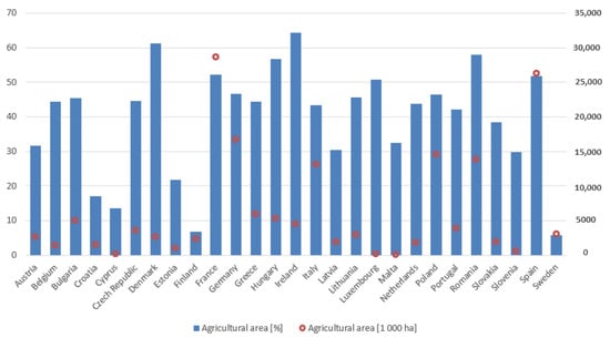
Figure 1. Agricultural area from the total area in individual EU countries. Source: own study based on data from the FAO Estimate, 2019 [52].
Poland takes 9th place out of 27 EU member states, where 1st place is the largest percentage of agricultural area in relation to the country’s area. Notice that Finland and Sweden have a low percentage. For example, Finland has the same amount of agricultural land as Denmark. Because Finland and Sweden are large countries with large amounts of forests, their percentage here is low. Also, agricultural areas both in Sweden and Finland are concentrated in the southern parts, where municipal or provincial-level percentages can be high.
Additionally, the high fragmentation of the agricultural area in Poland makes us one of the leading countries that urgently needs land consolidation in rural areas [44,53,54,55,56]. The problem of excessive land fragmentation affects many countries. One can read in the literature that it occurs, among others, in Bulgaria [57,58], in the Republic of Belarus [59], in Cyprus [60], in the Czech Republic [61], in Estonia [62], in Finland [63,64], in Hungary [65], in Latvia [66], in Lithuania [67], in Slovakia [68], in Spain [69], in The Netherlands [70,71], and in Ukraine [72].
In Poland, since 2008, the number of cadastral plots has been systematically increasing. Over the past 12 years, the number of cadastral plots has increased by over 3 million. The number of cadastral plots is systematically increasing as a result of dividing real estate. In Finland, agricultural plots are only a small minority of cadastral plots; this number does not show fragmentation at agricultural plots. In Finland, they follow agricultural administration IACS-systems information en masse to show real cultivated parcels (regardless of ownership).
4. The Impact of Land Consolidation on Energy Efficiency
The land consolidation processes in Poland focus not only on the geometric and location aspects of the farm but also, to a greater extent, on translating these into economic and ecological aspects. Such activities are in line with the directions of the European Green Deal and will certainly translate into reduced energy consumption and a lower carbon footprint [9,73]. Authors [74] suggest that moderate changes in food diets and land use in Finland can reduce GHG emissions from agriculture by more than 40% by 2050. In the period 2021–2030, the collective target of EU Member States is to reduce greenhouse gas emissions by 30% from the 2005 level by 2030 [5].
Better road planning in the land consolidation project will result in reduced agricultural production costs, lower fuel consumption, and a smaller carbon footprint. The basic elements of transport infrastructure are agricultural roads (access to fields). Hence, the high share of agricultural transport costs can be reduced through an appropriate system of these [75] roads. Each newly separated cadastral plot in the land consolidation in rural areas must have access to a public road. Consequently, the road infrastructure in a land consolidation project is extremely important. The road network density indicator is often mentioned by communes as the most important consolidation effect [46]. A very important effect of land consolidation in rural areas is post-merger management, including the arrangement and modernisation of “agricultural transport roads,” which provide access to each registration plot [46]. The paper [75] describes the influence of the distribution—the arrangement of fields in relation to the economic center—on the distance and the expenditure incurred in internal transport. The conclusions from these studies are as follows: Fuel consumption costs are 92.25% [75] lower after consolidating land and arranging all cadastral plots around the farm.
This entry is adapted from the peer-reviewed paper 10.3390/en16227598
This entry is offline, you can click here to edit this entry!