Your browser does not fully support modern features. Please upgrade for a smoother experience.
Submitted Successfully!
 +1 credit
Thank you for your contribution! You can also upload a video entry or images related to this topic.
For video creation, please contact our Academic Video Service.
| Version | Summary | Created by | Modification | Content Size | Created at | Operation |
|---|---|---|---|---|---|---|
| 1 | Mukhtar Iderawumi Abdulraheem | -- | 3595 | 2023-11-15 03:01:56 | | | |
| 2 | Jessie Wu | -1 word(s) | 3594 | 2023-11-15 04:00:49 | | | | |
| 3 | Jessie Wu | + 2 word(s) | 3596 | 2023-11-15 04:01:46 | | |
Video Upload Options
We provide professional Academic Video Service to translate complex research into visually appealing presentations. Would you like to try it?
Cite
If you have any further questions, please contact Encyclopedia Editorial Office.
Abdulraheem, M.I.; Zhang, W.; Li, S.; Moshayedi, A.J.; Farooque, A.A.; Hu, J. Remote Sensing Methods for Soil Measurements. Encyclopedia. Available online: https://encyclopedia.pub/entry/51572 (accessed on 30 July 2026).
Abdulraheem MI, Zhang W, Li S, Moshayedi AJ, Farooque AA, Hu J. Remote Sensing Methods for Soil Measurements. Encyclopedia. Available at: https://encyclopedia.pub/entry/51572. Accessed July 30, 2026.
Abdulraheem, Mukhtar Iderawumi, Wei Zhang, Shixin Li, Ata Jahangir Moshayedi, Aitazaz A. Farooque, Jiandong Hu. "Remote Sensing Methods for Soil Measurements" Encyclopedia, https://encyclopedia.pub/entry/51572 (accessed July 30, 2026).
Abdulraheem, M.I., Zhang, W., Li, S., Moshayedi, A.J., Farooque, A.A., & Hu, J. (2023, November 15). Remote Sensing Methods for Soil Measurements. In Encyclopedia. https://encyclopedia.pub/entry/51572
Abdulraheem, Mukhtar Iderawumi, et al. "Remote Sensing Methods for Soil Measurements." Encyclopedia. Web. 15 November, 2023.
Copy Citation
Soil is a diverse and intricate natural asset and the foundation for nearly all agricultural production endeavors because its physiochemical properties and nutrients play essential functions in understanding the ecosystem’s dynamics. Remote sensing (RS) techniques offer advantages over other methods for measuring soil properties, including large-scale coverage, a non-destructive nature, temporal monitoring, multispectral capabilities, and rapid data acquisition. The different detection methods, types, parts, and applications of RS techniques in soil measurements are highlighted, as well as the advantages and disadvantages of the measurements of soil properties.
remote sensing (RS)
soil properties and variability
multispectral analysis
satellite sensing
1. Introduction
In agriculture, remote sensing (RS) methods are increasingly used to gather data on crop health, soil moisture, erosion, and soil characteristics across large areas [1]. These techniques utilize various sensors and platforms to collect data from a distance, allowing for the large-scale, accurate, fast, and non-destructive analysis of soil characteristics [2]. The sections discuss the overview and explanation of remote sensing methods for soil analysis (spectral reflectance analysis, thermal infrared imaging, and radar remote sensing), key soil monitoring (e.g., moisture contents, organic matter, texture, fertility, and temperature) with various RS applications, as well as the RS parts used in soil monitoring. The utilization of technology in understanding the environment is truly unique and empowers us to make well-informed decisions [3][4][5].
2. Remote Sensing Methods in Soil Measurements
2.1. Spectral Reflectance Analysis
Spectral reflectance analysis is one of the most widely used RS techniques for soil property assessment [6]. It involves measuring the reflectance of electromagnetic radiation across different wavelengths, typically in the visible and near-infrared regions [7]. Different soil properties exhibit unique spectral signatures, allowing for their identification and quantification. The reflectance patterns observed in different wavelength ranges can provide information about various soil properties [8]. For example, the visible range (400–700 nm) can indicate the presence of organic matter and iron oxide minerals. Near-infrared reflectance (700–1300 nm) is sensitive to soil moisture content and clay mineralogy. Shortwave infrared reflectance (1300–2500 nm) can be used to estimate soil organic carbon content and identify specific minerals like gypsum or calcite [9].
2.2. Thermal Infrared Imaging
Thermal infrared imaging is another remote sensing method for assessing soil properties. It involves measuring the emitted thermal radiation from the Earth’s surface in the longwave infrared region (8–14 μm) [10]. Soil temperature is strongly influenced by moisture, texture, and organic matter content. By analyzing thermal infrared images, it is possible to estimate soil moisture levels and identify areas with variations in water availability [11]. Thermal infrared imaging can also detect variations in soil compaction and fertility. Compacted soils have lower porosity, reducing water infiltration rates and increasing surface temperatures [12]. By analyzing thermal patterns, it is possible to identify areas of soil compaction and assess their impact on plant growth.
2.3. Radar Remote Sensing
Radar remote sensing utilizes microwave signals to assess soil properties [13]. Microwaves can penetrate the soil surface, allowing for the measurement of subsurface characteristics. Radar sensors use electromagnetic waves to move down the soil, which can provide updates about moisture content and texture [14]. Radar sensors can provide information about soil moisture content, surface roughness, and texture with microwave signals interacting differently with different soil properties. By measuring the backscattered radar signal, which, when wet, has a higher dielectric constant, resulting in increased signal attenuation, it is possible to estimate soil moisture content [15]. Surface roughness can also be assessed using radar remote sensing, as rougher surfaces scatter more microwave energy. Soil texture, which refers to the relative proportions of sand, silt, and clay particles, can also be estimated using radar remote sensing. Different soil textures exhibit distinct radar backscatter responses due to variations in surface roughness and dielectric properties [16].
3. Remote Sensing Parts in Soil Measurements
RS techniques have significantly advanced in soil measurements using satellite, airborne, and ground-based methods for measuring soil erosion, identifying areas with high soil moisture content, and mapping soil nutrients [17]. It is also helpful in detecting soil contamination and evaluating soil fertility [18]. Figure 1 gives a thorough overview and stages of RS methods for soil analysis (spectral reflectance analysis, thermal infrared imaging, and radar remote sensing); tools for soil monitoring (e.g., LiDAR, hyperspectral, visible infrared, scanners, cameras, etc.) with various RS applications, as well as the RS parts used in soil monitoring.
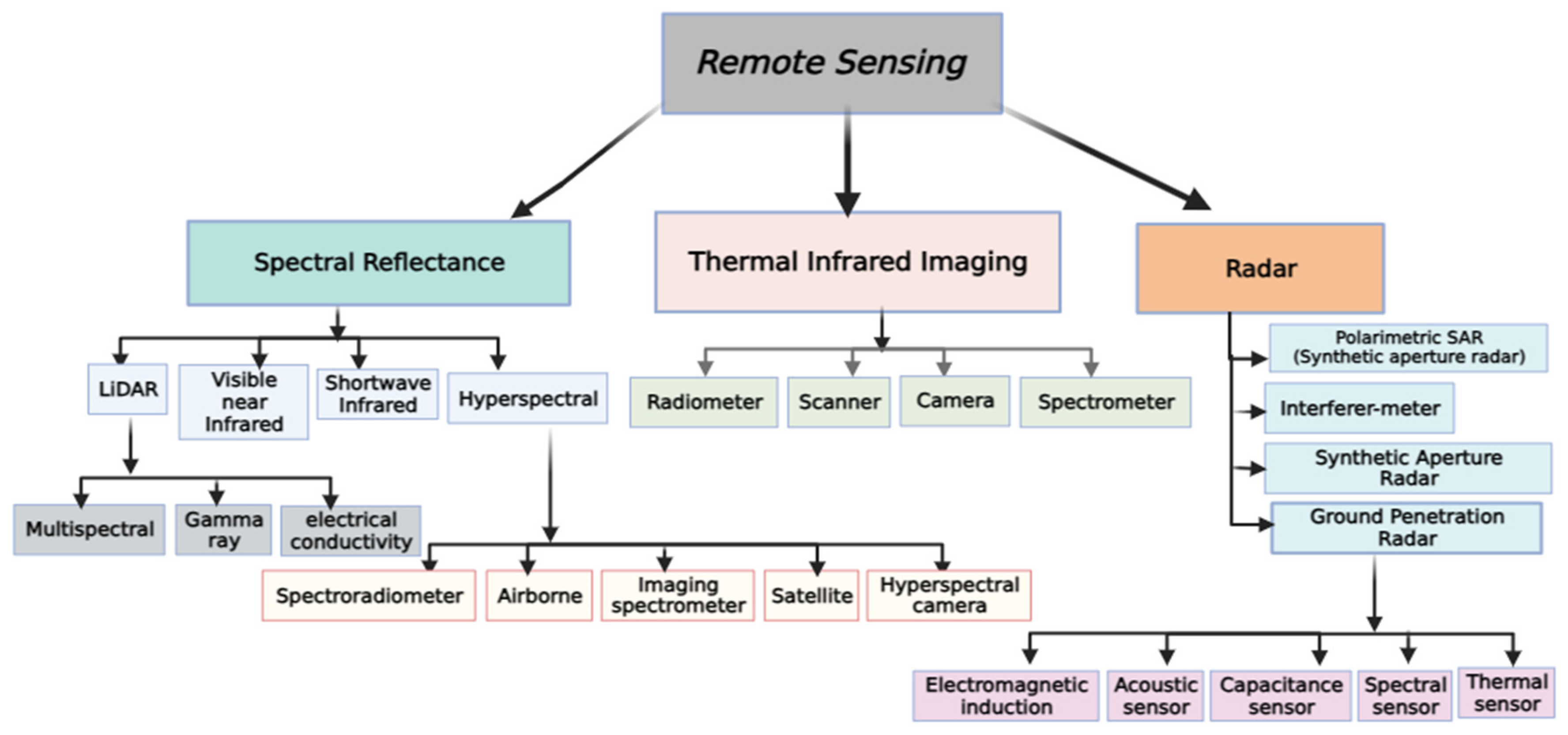
Figure 1. Remote sensing methods and types in soil measurements.
RS is particularly beneficial in areas where soil samples are scarce or traditional sampling methods are impractical due to the terrain [19]. Furthermore, RS can provide data at various scales, ranging from individual fields to entire watersheds, facilitating a more extensive comprehension of soil variability. Remote sensors can offer high-resolution data across broad areas, mapping soil parameters such as organic carbon concentration and moisture content [20]. Hyperspectral RS has proven effective in accurately mapping soil properties and detecting erosion [21]. With the changes in land cover patterns, RS can identify erosion-prone areas and help implement soil conservation measures and land management strategies. However, in the case of an unmanned aerial vehicle (UAV) camera observing at nadir, the view zenith angle (VZA) was specified as 0°, as depicted in Figure 2. The VZA will move the sensor to the leading solar plane if the results are positive. Conversely, negative numbers indicate that the VZA is moving backward, with the sensor pointing away from the sun.
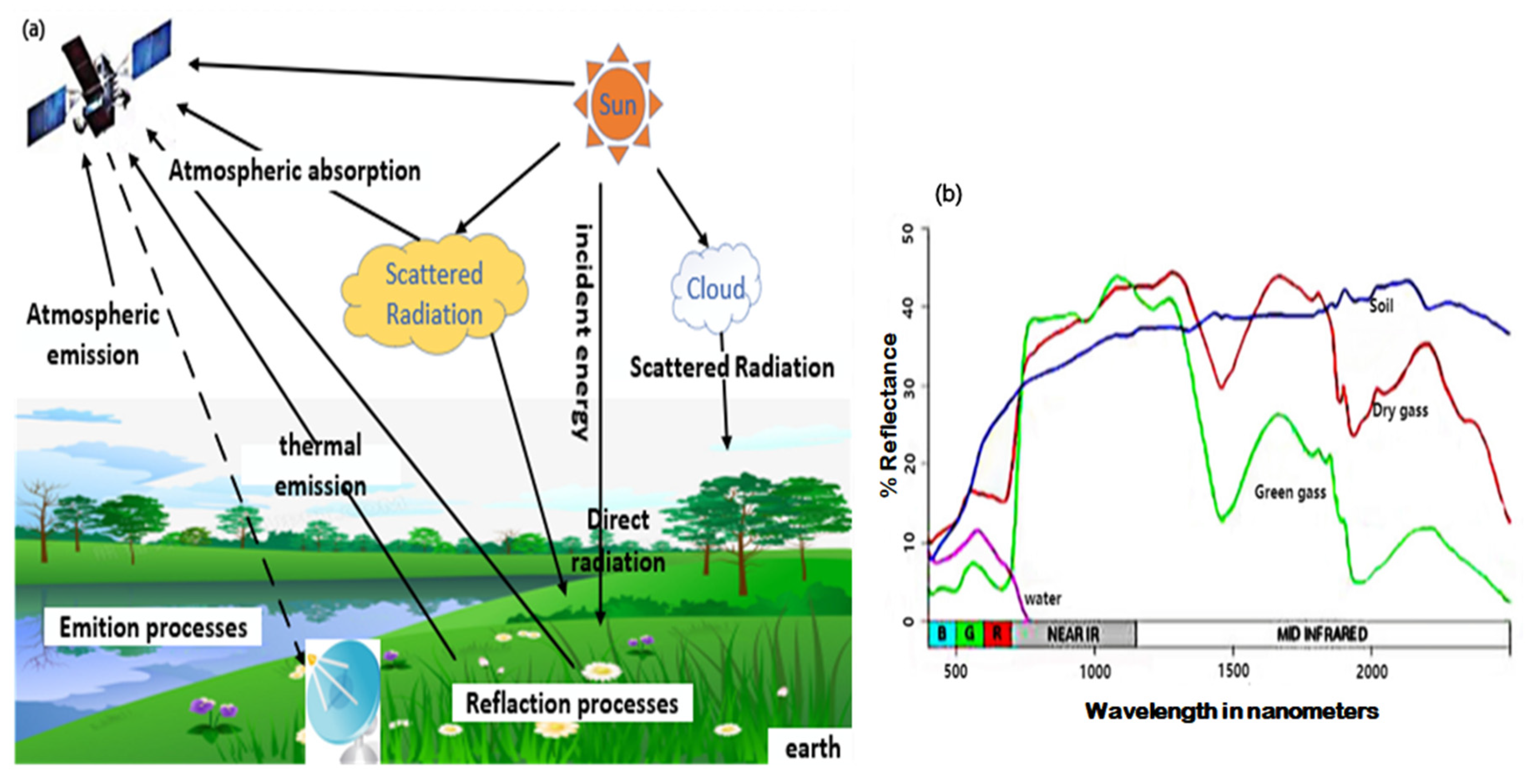
Figure 2. Basic concept of remote sensing (a) Multi-angle remote sensing data acquisition processes (b) View zenith angle (VZA) time series reflect data.
On the upper left of the diagram, color bars beneath the UAV depict the four types of remotely sensed data. The data type directs scientists to the relevant data products, indicated by the circles on the right-hand side. The data output items are grouped based on their estimated delivery time. Some crucial measures rely on picture indices and do not require multiple image calibrations. The white circles on the left side of the diagram indicate data acquired at significant field sites for this inquiry. After spectral retrieval, additional analysis can be performed. The algorithms on the lower right require geographic information system (GIS) inputs to geolocate and register the picture to ground coordinates, which explores the extent to which geographic registration is possible in real time [22]. The schematic picture in Figure 3a indicates the process by which the satellite acquires a network via the UAV, which receives signals and acquires data from the field (agricultural field—soil and air) and reflects the base station where data is processed and transferred via the internet for interpretation and analysis (relevant data extraction, data consensus), and finally transmits data to the UAV for application to soil monitoring.
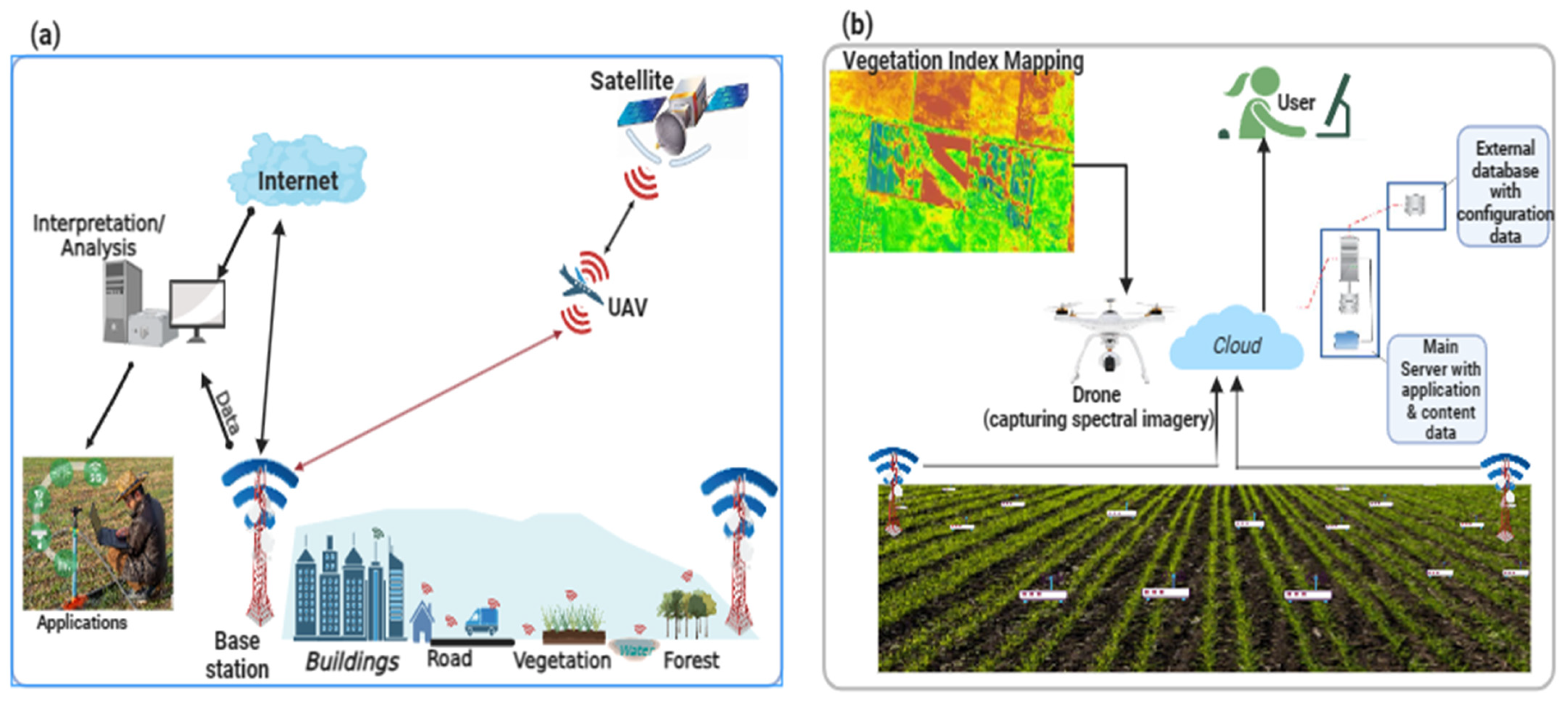
Figure 3. Applications of remote sensing: (a) integrated UAV concepts; (b) remote sensing system operation.
Figure 3b illustrates a wireless sensor network system with multiple nodes. Each node comprises a soil moisture sensor to monitor water level, a soil temperature sensor, and air temperature and humidity sensors. In conclusion, RS methods offer valuable tools for assessing and monitoring soil properties. Spectral reflectance analysis provides insights into soil characteristics based on their unique spectral signatures. Thermal infrared imaging allows for estimates of soil moisture content, compaction levels, and fertility variations. Radar remote sensing enables the assessment of soil moisture content, surface roughness, and texture. These techniques contribute to a better understanding of soil dynamics and support informed decision-making in agriculture, land management, and environmental studies.
4. Remote Sensing Application in Soil Measurements
RS has emerged as a powerful tool for studying various soil properties, and its applications range from estimating soil moisture content and monitoring soil erosion to mapping soil organic carbon content and assessing soil salinity levels [23]. It involves acquiring of data from a distance, typically using satellite or airborne sensors, to gather information about soil properties [24]. These data can then be analyzed to extract meaningful insights about soil properties and their applications (Table 1). The applications of RS to soil properties are diverse and encompass several important aspects of soil science. For example, near-infrared reflectance can estimate vegetation cover and biomass production, while thermal infrared measurements can measure soil moisture content. By combining data from multiple wavelengths or sensors, researchers can better understand soil characteristics and their interactions with the environment [25][26]. It should be noted that by providing valuable insights into these soil properties, remote sensing contributes significantly to sustainable land management practices, agricultural productivity, and environmental conservation efforts.
Table 1. Comparison of different remote sensing applications for soil measurements.
| Soil Property | Remote Sensing Methods | Descriptions | References |
|---|---|---|---|
| Soil Reflectance | Optical and multispectral imaging |
|
[27] |
| Soil Albedo | Optical and multispectral imaging |
|
[28] |
| Spectral Signatures | Spectral analysis, hyperspectral imaging |
|
[29] |
| Spectral Indices | Spectral analysis, multispectral imaging |
|
[30] |
| Soil Temperature | Thermal infrared imaging, thermal sensors |
|
[31] |
| Soil Moisture | Microwave RS, Thermal sensors |
|
[32] |
| Soil Roughness | Microwave remote sensing, LiDAR |
|
[33] |
| Soil Electrical Conductivity (EC) | Geophysical methods (EM, GPR) |
|
[34] |
| Soil Permeability | Geophysical methods (GPR) |
|
[35] |
| Soil Composition | Multispectral and hyperspectral imaging |
|
[36] |
| Vegetation Cover | Multispectral and hyperspectral imaging |
|
[37] |
| Soil Topography | LiDAR |
|
[38] |
| Soil Surface Characteristics | Radar imaging |
|
[39] |
| Change Detection | Multi-temporal analysis, radar, optical imagery |
|
[40] |
| Data Fusion and Integration | Integrating multiple remote sensing data |
|
[4] |
| Soil pH | Thermal infrared imaging, thermal sensors |
|
[41] |
In Table 1, the comparison of different RS methods used in soil measurements was examined and discussed, which covers several soil properties and describes the RS methods involved in the measurements. RS has shown valuable skill in monitoring daily or temporary soil characteristics, which change with time based on factors such as time of day, weather, season, and climate. Table 1 further shows that RS applications for soil measurements significantly advanced our understanding and offer valuable insight into soil processes, properties, erosion, moisture content, fertility, and other crucial factors influencing agricultural productivity and environmental management, such as spectral reflectance analysis, thermal infrared imaging, LiDAR, and hyperspectral imaging, which are critical techniques used in this field. Each technique has its strengths and limitations, and their selection depends on the study’s specific objectives and the desired level of detail required for soil analysis.
RS technology is a cost-effective and efficient tool for soil monitoring. It helps scientists and policymakers make informed decisions about agricultural practices, land use planning, and environmental conservation. Soil characteristics can be accurately detected and monitored via laboratory analysis and real-time measurements [3][4]. Due to the increasing demand for information, spectral responses can be utilized to evaluate surface and subsurface soil properties, but soil property monitoring techniques need updating [5]. Nevertheless, the benefits of remote sensing data in soil measurements far outweigh the limitations, making it an indispensable tool for soil scientists and environmental managers [42].
5. Remote Sensing Techniques in Soil Measurements
Remote sensing (RS) tools encompass many technologies and techniques that enable us to gather valuable data about the soil from a distance. Satellite-based tools offer global coverage and continuous monitoring capabilities (equipped with sensors that capture data in different wavelengths of the electromagnetic spectrum, including visible, infrared, and microwave) but have limitations regarding spatial resolution and cloud cover interference. In contrast, aerial-based tools provide higher spatial resolution for detailed mapping and monitoring of smaller areas but are limited by flight restrictions and higher costs (Table 2). Ground-based devices offer high-resolution data at close range and can provide detailed information about specific areas or objects of interest. Each type of remote sensing tool has its advantages and limitations, making them suitable for different applications and research needs.
Table 2. Comparison of different remote sensing tools in soil measurements.
| Remote Sensing Tools | Advantages | Disadvantages | References |
|---|---|---|---|
| Satellite Imagery | Provides wide coverage, regular data capture, multispectral and hyperspectral capabilities for detailed analysis | Limited spatial resolution and control over data acquisition | [43][44] |
| Unmanned Aerial Vehicles (UAVs) and Drones | High-resolution imagery, offering flexibility in flight paths, cost effective for small-scale projects, and data acquisition timing | Limited coverage area and regulatory restrictions on flight altitude | [38][45][46][47] |
| LiDAR (Light Detection and Ranging) | Comprehensive data on topography, vegetation structure, canopy height high-resolution, 3D mapping capabilities and can penetrate vegetation cover | Expensive and limited penetration capabilities | [48][49] |
| Thermal Imaging | Non-destructive, continuous monitoring measures soil temperature and moisture, identifying water stress and irrigation needs | Requires clear sky conditions for accurate temperature and limited to surface soil temperature monitoring | [31][50] |
| Soil Moisture Sensors | Accurate monitoring, directly measuring soil moisture content at different depths, providing real-time data and integration for continuous monitoring | Limited coverage area and requires physical installation in the soil | [5] |
| Hyperspectral imaging | High spectral resolution, improved detection, classification capabilities, enhanced data analysis, non-destructive and non-contact | Limited spatial coverage, high data processing, complexity, costly, limited availability and accessibility | [29][37][38] |
| Ground-based remote sensing | High spatial resolution, real-time data collection, efficiency, and direct measures reflectance at different wavelengths to estimate soil composition and nutrient contents | Physical access to the soil surface can be challenging in certain terrains or land uses | [18][32] |
| Radar system | Versatility, all-weather capability, depth perception, high resolution, large-scale coverage, long-distance capability, and ability to combine multiple radar measurements | Limited resolution, complexity, cost, limited spectral information, and interference | [18] |
| Infrared (IR) sensors | Non-contact, versatile application, fast and real-time data, wide coverage and high accuracy | Limited depth perception, influenced by environmental factors, limited penetration capability, cost, and limited spectral resolution | [50][51] |
| Optical sensors | High spatial resolution, multispectral capabilities, wide coverage, long-term data collection, and cost effective | Susceptibility to weather conditions, limited visibility, temporal resolution, limited data processing, and interpretation | [28][52][53][54] |
| Aerial Photography | High spatial resolution, flexibility, and rapid deployment | Limited coverage, weather dependency, and higher cost | [55] |
| Microwaves | Mapping vegetation, all-day operation, reliability, effectiveness, and obtaining data in adverse weather conditions | Lower spatial resolution, limited spectral information, reliance on active sensors, complex data interpretation, and limited availability of free data | [13][21] |
Based on Table 2 above, various remote sensing tools offer distinct benefits for measuring soil, as satellite-based remote sensing can provide global coverage and long-term monitoring but may not offer a detailed spatial resolution. On the other hand, airborne remote sensing provides higher spatial resolution and more detailed information but requires specialized equipment and is more expensive. Ground-based remote sensing tools offer direct measurements at close range with high spatial resolution but have a limited coverage area. Lidar remote sensing can give detailed information about topography and vegetation structure but comes with cost considerations. Ultimately, selecting the most suitable remote sensing tool will depend on the specific study objectives, the scale of analysis, and available resources.
RS techniques such as thermal, radar, hyperspectral, and optical sensors are used for soil analysis to detect the characteristics of objects and materials from a distance during soil property measurement [56][57]. Most detection modes depend on photons tested at their related electromagnetic (EM) frequency [58] because the frequency and force of energy reflected or transmitted by the highlights in the scene being detected are usually identified and recorded by distant sensors. It should be noted that the electromagnetic radiation spectrum (EMR) comprises particles that travel in waves, and visible light is the most visible form of electromagnetic magnetic radiation.
It is worth noting that mechanical sensors measuring soil penetration resistance are often used and combined with other sensors [59][60][61]. This is demonstrated in various studies on remote sensor measurements, as shown in Table 3, whose applications range from soil compaction assessment [62] to 3D modeling of soil layers.
Table 3. Reviewed studies on remote sensors for measuring soil and related properties.
| RS Method | Remote Sensor for Measuring Soil and Related Properties | Investigated Parameters | Applications | Highlights | References |
|---|---|---|---|---|---|
| Hyperspectral Imaging | Apparent Electrical Conductivity (ECa) (two sensors) | Cation exchange capacity; organic carbon; electrical conductivity; Depth to argillic horizon | The ECa of the two sensors should be compared. It is necessary to estimate a variety of soil properties. | The study improved soil properties estimation by combining ECa sensor fusion and data from various fields, with the highest R2 predicted for the depth to the argillic horizon. | [62] |
| Reflectance Spectroscopy | ECa; Crop yield | pH; Calcium carbonate, elevation; stream power index; slope; organic carbon, wetness index; particle size distribution | To create a map of various soil properties and crop yield estimation, and determine variables for delineation management | The study found ECa was positively correlated with clay and negatively correlated with sand content, indicating field discrepancy. Landscape location and soil moisture were linked to management zones, and crop yields varied by management zone | [63][64] |
| Airborne LiDAR | ECa (two sensors | Sodium; Calcium, Potassium; Magnesium; Sulphur; Nitrogen; Phosphorus; cation exchange capacity; particle size distribution soil pH; soluble salts (implied) |
Determine the relationship between ECa and several soil characteristics | ECa was predicted in six research locations using clay content, silt content, soluble salts, Na, Ca, Mg, and CEC, with strong correlations with clay content and Mg in four fields | [65] |
| Electrochemical Sensor | Visible-Near Infrared spectra; ECa |
Organic Carbon; Electrical Conductivity; Carbon-to-Nitrogen ratio; Particle size distribution; Soil pH | Multiple soil qualities were estimated | With an R2 of 9.3 × 10⁻³, Visible/near-infrared spectra alone, ECa alone, and sensor fusion collectively produced the best soil property estimates | [44][66] |
| Electrochemical Sensor | Crop yield, Total carbon, Mechanical resistance; Capacitance probe; output voltage; Cone index |
Bulk density, Organic matter; Clay content | Multiple soil properties were estimated and mapped. Crop yield mapping | The study estimated sand content, silt, and clay content with the highest R2 (0.90) at 0 to 28 cm from R, and found similar patterns in bulk density, mechanical resistance, and organic matter on crop yield maps | [67] |
The platform’s altitude, the image’s spatial resolution, and the reduced return frequency for arranged sensors are the distinguishing factors for these platforms and imaging systems [68]. Calculating different soil properties can be a valuable tool for farmers, gardeners, and others who work with soil [69]. When analyzing temporal patterns in soil and plant properties, the frequency of data collection is a crucial factor to consider. However, it is essential to note that cloud cover can affect RS images from satellites and aerial platforms, although it has a more negligible impact on ground-based remote sensing [70]. Utilizing RS is an effective method for evaluating the surface characteristics of the ground from afar. This technique assesses the chemical and physical properties of the soil matrix by measuring the upwelling electromagnetic radiation emitted or reflected from the soil [71]. With the information obtained via RS, researchers can distinguish differences between soil extrapolate characteristics and the soil surfaces from the radiation observed. RS technologies are widely acknowledged for providing a valuable tool for obtaining geographically and chronologically diverse information to assess soil properties accurately [72]. To account for geographically varying crop responses, information on soil variability may need to be coupled with plant information in both scenarios to improve in-season fertilization [55][56][73]. Understanding how things change over time is made more accessible by analyzing spatiotemporal changes. High-resolution tracking of spectral and spatial data changes is possible with the aid of RS. It can gain an understanding of how our environment changes because of its capacity to observe and track changes in great detail over time [74].
References
- Rodríguez-Lozano, B.; Rodríguez-Caballero, E.; Maggioli, L.; Cantón, Y. Non-Destructive Biomass Estimation in Mediterranean Alpha Steppes: Improving Traditional Methods for Measuring Dry and Green Fractions by Combining Proximal Remote Sensing Tools. Remote Sens. 2021, 13, 2970.
- Benami, E.; Jin, Z.; Carter, M.R.; Ghosh, A.; Hijmans, R.J.; Hobbs, A.; Kenduiywo, B.; Lobell, D.B. Uniting remote sensing, crop modelling and economics for agricultural risk management. Nat. Rev. Earth Environ. 2021, 2, 140–159.
- Kumar, S.; Gautam, G.; Saha, S.K. Hyperspectral remote sensing data derived spectral indices in characterizing salt-affected soils: A case study of Indo-Gangetic plains of India. Environ. Earth Sci. 2015, 73, 3299–3308.
- Ciampalini, A.; André, F.; Garfagnoli, F.; Grandjean, G.; Lambot, S.; Chiarantini, L.; Moretti, S. Improved estimation of soil clay content by the fusion of remote hyperspectral and proximal geophysical sensing. J. Appl. Geophys. 2015, 116, 135–145.
- Salvatore, M.R.; Barrett, J.E.; Fackrell, L.E.; Sokol, E.R.; Levy, J.S.; Kuentz, L.C.; Gooseff, M.N.; Adams, B.J.; Power, S.N.; Knightly, J.P.; et al. The Distribution of Surface Soil Moisture over Space and Time in Eastern Taylor Valley, Antarctica. Remote Sens. 2023, 15, 3170.
- Demattê, J.A.M.; Fongaro, C.T.; Rizzo, R.; Safanelli, J.L. Geospatial Soil Sensing System (GEOS3): A powerful data mining procedure to retrieve soil spectral reflectance from satellite images. Remote Sens. Environ. 2018, 212, 161–175.
- Mohamed, E.S.; Saleh, A.M.; Belal, A.B.; Gad, A.A. Application of near-infrared reflectance for quantitative assessment of soil properties. Egypt. J. Remote Sens. Space Sci. 2018, 21, 1–14.
- Zahir, S.A.D.M.; Omar, A.F.; Jamlos, M.F.; Azmi, M.A.M.; Muncan, J. A review of visible and near-infrared (Vis-NIR) spectroscopy application in plant stress detection. Sens. Actuators A Phys. 2022, 338, 113468.
- Balaram, V.; Sawant, S.S. Indicator Minerals, Pathfinder Elements, and Portable Analytical Instruments in Mineral Exploration Studies. Minerals 2022, 12, 394.
- Farella, M.M.; Fisher, J.B.; Jiao, W.; Key, K.B.; Barnes, M.L. Thermal remote sensing for plant ecology from leaf to globe. J. Ecol. 2022, 110, 1996–2014.
- Khanal, S.; Fulton, J.; Shearer, S. An overview of current and potential applications of thermal remote sensing in precision agriculture. Comput. Electron. Agric. 2017, 139, 22–32.
- Manolakis, D.; Pieper, M.; Truslow, E.; Lockwood, R.; Weisner, A.; Jacobson, J.; Cooley, T. Longwave Infrared Hyperspectral Imaging: Principles, Progress, and Challenges. IEEE Geosci. Remote Sens. Mag. 2019, 7, 72–100.
- Fingas, M.; Brown, C.E. A Review of Oil Spill Remote Sensing. Sensors 2018, 18, 91.
- Petropoulos, G.P.; Ireland, G.; Barrett, B. Surface soil moisture retrievals from remote sensing: Current status, products & future trends. Phys. Chem. Earth Parts A/B/C 2015, 83, 36–56.
- Li, Y.-y.; Zhao, K.; Ren, J.-h.; Ding, Y.-l.; Wu, L.-l. Analysis of the Dielectric Constant of Saline-Alkali Soils and the Effect on Radar Backscattering Coefficient: A Case Study of Soda Alkaline Saline Soils in Western Jilin Province Using RADARSAT-2 Data. Sci. World J. 2014, 2014, 563015.
- Gharechelou, S.; Tateishi, R.; Sumantyo, J.T.S. Interrelationship analysis of L-band backscattering intensity and soil dielectric constant for soil moisture retrieval using PALSAR data. Adv. Remote Sens. 2015, 4, 15.
- Cuenca-García, C.; Risbøl, O.; Bates, C.R.; Stamnes, A.A.; Skoglund, F.; Ødegård, Ø.; Viberg, A.; Koivisto, S.; Fuglsang, M.; Gabler, M. Sensing archaeology in the north: The use of non-destructive geophysical and remote sensing methods in archaeology in Scandinavian and North Atlantic territories. Remote Sens. 2020, 12, 3102.
- Iftimie, N.; Savin, A.; Steigmann, R.; Dobrescu, G.S. Underground pipeline identification into a non-destructive case study based on ground-penetrating radar imaging. Remote Sens. 2021, 13, 3494.
- Raj, M.; Gupta, S.; Chamola, V.; Elhence, A.; Garg, T.; Atiquzzaman, M.; Niyato, D. A survey on the role of Internet of Things for adopting and promoting Agriculture 4.0. J. Netw. Comput. Appl. 2021, 187, 103107.
- Wang, B.; Waters, C.; Orgill, S.; Gray, J.; Cowie, A.; Clark, A.; Li Liu, D. High resolution mapping of soil organic carbon stocks using remote sensing variables in the semi-arid rangelands of eastern Australia. Sci. Total Environ. 2018, 630, 367–378.
- Lu, B.; Dao, P.D.; Liu, J.; He, Y.; Shang, J. Recent advances of hyperspectral imaging technology and applications in agriculture. Remote Sens. 2020, 12, 2659.
- Zribi, M.; Baghdadi, N.; Nolin, M. Remote sensing of soil. Appl. Environ. Soil Sci. 2011, 2011, 904561.
- van Wesemael, B.; Chabrillat, S.; Sanz Dias, A.; Berger, M.; Szantoi, Z. Remote Sensing for Soil Organic Carbon Mapping and Monitoring. Remote Sens. 2023, 15, 3464.
- Schuster, J.; Hagn, L.; Mittermayer, M.; Maidl, F.-X.; Hülsbergen, K.-J. Using Remote and Proximal Sensing in Organic Agriculture to Assess Yield and Environmental Performance. Agronomy 2023, 13, 1868.
- Adamchuk, V.I.; Hummel, J.W.; Morgan, M.T.; Upadhyaya, S.K. On-the-go soil sensors for precision agriculture. Comput. Electron. Agric. 2004, 44, 71–91.
- Wang, J.; Zhen, J.; Hu, W.; Chen, S.; Lizaga, I.; Zeraatpisheh, M.; Yang, X. Remote sensing of soil degradation: Progress and perspective. Int. Soil Water Conserv. Res. 2023, 11, 429–454.
- Li, Y.; Dang, B.; Zhang, Y.; Du, Z. Water body classification from high-resolution optical remote sensing imagery: Achievements and perspectives. ISPRS J. Photogramm. Remote Sens. 2022, 187, 306–327.
- Zhu, Q.-B.; Li, B.; Yang, D.-D.; Liu, C.; Feng, S.; Chen, M.-L.; Sun, Y.; Tian, Y.-N.; Su, X.; Wang, X.-M.; et al. A flexible ultrasensitive optoelectronic sensor array for neuromorphic vision systems. Nat. Commun. 2021, 12, 1798.
- Shaik, R.U.; Periasamy, S.; Zeng, W. Potential Assessment of PRISMA Hyperspectral Imagery for Remote Sensing Applications. Remote Sens. 2023, 15, 1378.
- Zhu, X.X.; Bamler, R. A sparse image fusion algorithm with application to pan-sharpening. IEEE Trans. Geosci. Remote Sens. 2012, 51, 2827–2836.
- Ghilain, N.; Arboleda, A.; Batelaan, O.; Ardö, J.; Trigo, I.; Barrios, J.-M.; Gellens-Meulenberghs, F. A New Retrieval Algorithm for Soil Moisture Index from Thermal Infrared Sensor On-Board Geostationary Satellites over Europe and Africa and Its Validation. Remote Sens. 2019, 11, 1968.
- Ilčev, S.D. Satellite Meteorological Parameters. In Global Satellite Meteorological Observation (GSMO) Theory; Springer: Berlin/Heidelberg, Germany, 2018; Volume 1, pp. 293–362.
- Marchant, B.P. Using remote sensors to predict soil properties: Radiometry and peat depth in Dartmoor, UK. Geoderma 2021, 403, 115232.
- Lobsey, C.R.; Rossel, R.A.V.; McBratney, A.B. Proximal Soil Nutrient Sensing Using Electrochemical Sensors. In Proximal Soil Sensing; Viscarra Rossel, R.A., McBratney, A.B., Minasny, B., Eds.; Springer: Dordrecht, The Netherlands, 2010; pp. 77–88.
- Ahmadi, A.; Emami, M.; Daccache, A.; He, L. Soil properties prediction for precision agriculture using visible and near-infrared spectroscopy: A systematic review and meta-analysis. Agronomy 2021, 11, 433.
- Yu, H.; Kong, B.; Wang, Q.; Liu, X.; Liu, X. Hyperspectral Remote Sensing Applications in Soil: A Review. In Hyperspectral Remote Sensing; Pandey, P.C., Srivastava, P.K., Balzter, H., Bhattacharya, B., Petropoulos, G.P., Eds.; Elsevier: Amsterdam, The Netherlands, 2020; pp. 269–291.
- Angelopoulou, T.; Chabrillat, S.; Pignatti, S.; Milewski, R.; Karyotis, K.; Brell, M.; Ruhtz, T.; Bochtis, D.; Zalidis, G. Evaluation of Airborne HySpex and Spaceborne PRISMA Hyperspectral Remote Sensing Data for Soil Organic Matter and Carbonates Estimation. Remote Sens. 2023, 15, 1106.
- Sankey, T.T.; McVay, J.; Swetnam, T.L.; McClaran, M.P.; Heilman, P.; Nichols, M. UAV hyperspectral and lidar data and their fusion for arid and semi-arid land vegetation monitoring. Remote Sens. Ecol. Conserv. 2018, 4, 20–33.
- Kumar, S.; Meena, R.S.; Sheoran, S.; Jangir, C.K.; Jhariya, M.K.; Banerjee, A.; Raj, A. Remote Sensing for Agriculture and Resource Management. In Natural Resources Conservation and Advances for Sustainability; Elsevier: Amsterdam, The Netherlands, 2022; pp. 91–135.
- Kumar, P.S.J.; Huan, T.L.; Li, X.; Yuan, Y. Panchromatic and multispectral remote sensing image fusion using machine learning for classifying bucolic and farming region. Int. J. Comput. Sci. Eng. 2018, 15, 340–370.
- Khanal, S.; Kc, K.; Fulton, J.P.; Shearer, S.; Ozkan, E. Remote sensing in agriculture—Accomplishments, limitations, and opportunities. Remote Sens. 2020, 12, 3783.
- Kasampalis, D.A.; Alexandridis, T.K.; Deva, C.; Challinor, A.; Moshou, D.; Zalidis, G. Contribution of Remote Sensing on Crop Models: A Review. J. Imaging 2018, 4, 52.
- Peng, J.; Loew, A.; Merlin, O.; Verhoest, N.E.C. A review of spatial downscaling of satellite remotely sensed soil moisture. Rev. Geophys. 2017, 55, 341–366.
- Eldeeb, M.A.; Dhamu, V.N.; Paul, A.; Muthukumar, S.; Prasad, S. Electrochemical Soil Nitrate Sensor for In Situ Real-Time Monitoring. Micromachines 2023, 14, 1314.
- Candiago, S.; Remondino, F.; De Giglio, M.; Dubbini, M.; Gattelli, M. Evaluating multispectral images and vegetation indices for precision farming applications from UAV images. Remote Sens. 2015, 7, 4026–4047.
- Biney, J.K.M.; Saberioon, M.; Borůvka, L.; Houška, J.; Vašát, R.; Chapman Agyeman, P.; Coblinski, J.A.; Klement, A. Exploring the Suitability of UAS-Based Multispectral Images for Estimating Soil Organic Carbon: Comparison with Proximal Soil Sensing and Spaceborne Imagery. Remote Sens. 2021, 13, 308.
- Moshayedi, A.J.; Roy, A.S.; Taravet, A.; Liao, L.; Wu, J.; Gheisari, M. A Secure Traffic Police Remote Sensing Approach via a Deep Learning-Based Low-Altitude Vehicle Speed Detector through UAVs in Smart Cites: Algorithm, Implementation and Evaluation. Future Transp. 2023, 3, 189–209.
- Novero, A.U.; Pasaporte, M.S.; Aurelio, R.M., Jr.; Madanguit, C.J.G.; Tinoy, M.R.M.; Luayon, M.S.; Oñez, J.P.L.; Daquiado, E.G.B.; Diez, J.M.A.; Ordaneza, J.E. The use of light detection and ranging (LiDAR) technology and GIS in the assessment and mapping of bioresources in Davao Region, Mindanao Island, Philippines. Remote Sens. Appl. Soc. Environ. 2019, 13, 1–11.
- del-Moral-Martínez, I.; Rosell-Polo, J.R.; Company, J.; Sanz, R.; Escola, A.; Masip, J.; Martinez-Casasnovas, J.A.; Arnó, J. Mapping vineyard leaf area using mobile terrestrial laser scanners: Should rows be scanned on-the-go or discontinuously sampled? Sensors 2016, 16, 119.
- Yang, Y.; Guan, H.; Long, D.; Liu, B.; Qin, G.; Qin, J.; Batelaan, O. Estimation of Surface Soil Moisture from Thermal Infrared Remote Sensing Using an Improved Trapezoid Method. Remote Sens. 2015, 7, 8250–8270.
- Frodella, W.; Lazzeri, G.; Moretti, S.; Keizer, J.; Verheijen, F.G.A. Applying Infrared Thermography to Soil Surface Temperature Monitoring: Case Study of a High-Resolution 48 h Survey in a Vineyard (Anadia, Portugal). Sensors 2020, 20, 2444.
- Zedler, M.; Tse, S.W.; Ruiz-Gonzalez, A.; Haseloff, J. Paper-Based Multiplex Sensors for the Optical Detection of Plant Stress. Micromachines 2023, 14, 314.
- Gomez, C.; Gholizadeh, A.; Borůvka, L.; Lagacherie, P. Using legacy data for correction of soil surface clay content predicted from VNIR/SWIR hyperspectral airborne images. Geoderma 2016, 276, 84–92.
- Dvorak, J.S.; Stone, M.L.; Self, K.P. Object detection for agricultural and construction environments using an ultrasonic sensor. J. Agric. Saf. Health 2016, 22, 107–119.
- Roberts, D.F.; Adamchuk, V.I.; Shanahan, J.F.; Ferguson, R.B.; Schepers, J.S. Estimation of surface soil organic matter using a ground-based active sensor and aerial imagery. Precis. Agric. 2011, 12, 82–102.
- Yahia, O.; Guida, R.; Iervolino, P. Novel Weight-Based Approach for Soil Moisture Content Estimation via Synthetic Aperture Radar, Multispectral and Thermal Infrared Data Fusion. Sensors 2021, 21, 3457.
- Nie, W.; Kumar, S.V.; Bindlish, R.; Liu, P.-W.; Wang, S. Remote sensing-based vegetation and soil moisture constraints reduce irrigation estimation uncertainty. Environ. Res. Lett. 2022, 17, 084010.
- Walther, M.; Fischer, B.M.; Ortner, A.; Bitzer, A.; Thoman, A.; Helm, H. Chemical sensing and imaging with pulsed terahertz radiation. Anal. Bioanal. Chem. 2010, 397, 1009–1017.
- Huang, C.; Chen, Y.; Zhang, S.; Wu, J. Detecting, Extracting, and Monitoring Surface Water From Space Using Optical Sensors: A Review. Rev. Geophys. 2018, 56, 333–360.
- Meng, K.; Xiao, X.; Wei, W.; Chen, G.; Nashalian, A.; Shen, S.; Xiao, X.; Chen, J. Wearable Pressure Sensors for Pulse Wave Monitoring. Adv. Mater. 2022, 34, 2109357.
- Wei, Z.; Zhao, J.; He, H.; Ding, G.; Cui, H.; Liu, L. Future smart battery and management: Advanced sensing from external to embedded multi-dimensional measurement. J. Power Sources 2021, 489, 229462.
- Quraishi, M.Z.; Mouazen, A.M. Calibration of an on-line sensor for measurement of topsoil bulk density in all soil textures. Soil Tillage Res. 2013, 126, 219–228.
- Nagarajan, G.; Minu, R.I. Wireless soil monitoring sensor for sprinkler irrigation automation system. Wirel. Pers. Commun. 2018, 98, 1835–1851.
- Pei, X.; Sudduth, K.A.; Veum, K.S.; Li, M. Improving In-Situ Estimation of Soil Profile Properties Using a Multi-Sensor Probe. Sensors 2019, 19, 1011.
- Foldager, F.F.; Pedersen, J.M.; Haubro Skov, E.; Evgrafova, A.; Green, O. LiDAR-Based 3D Scans of Soil Surfaces and Furrows in Two Soil Types. Sensors 2019, 19, 661.
- Mahmood, H.S.; Hoogmoed, W.B.; van Henten, E.J. Sensor data fusion to predict multiple soil properties. Precis. Agric. 2012, 13, 628–645.
- Naderi-Boldaji, M.; Sharifi, A.; Alimardani, R.; Hemmat, A.; Keyhani, A.; Loonstra, E.H.; Weisskopf, P.; Stettler, M.; Keller, T. Use of a triple-sensor fusion system for on-the-go measurement of soil compaction. Soil Tillage Res. 2013, 128, 44–53.
- Messina, G.; Peña, J.M.; Vizzari, M.; Modica, G. A comparison of UAV and satellites multispectral imagery in monitoring onion crop. An application in the ‘Cipolla Rossa di Tropea’ (Italy). Remote Sens. 2020, 12, 3424.
- Verma, S.; Verma, R.K.; Mishra, S.K.; Singh, A.; Jayaraj, G.K. A revisit of NRCS-CN inspired models coupled with RS and GIS for runoff estimation. Hydrol. Sci. J. 2017, 62, 1891–1930.
- Mulla, D.J. Twenty five years of remote sensing in precision agriculture: Key advances and remaining knowledge gaps. Biosyst. Eng. 2013, 114, 358–371.
- Wong, M.S.; Zhu, X.; Abbas, S.; Kwok, C.Y.T.; Wang, M. Optical Remote Sensing. In Urban Informatics; Springer: Singapore, 2021; pp. 315–344.
- Abdollahi, S.; Madadi, M.; Ostad-Ali-Askari, K. Monitoring and investigating dust phenomenon on using remote sensing science, geographical information system and statistical methods. Appl. Water Sci. 2021, 11, 111.
- Argento, F.; Anken, T.; Abt, F.; Vogelsanger, E.; Walter, A.; Liebisch, F. Site-specific nitrogen management in winter wheat supported by low-altitude remote sensing and soil data. Precis. Agric. 2021, 22, 364–386.
- West, H.; Quinn, N.; Horswell, M. Remote sensing for drought monitoring & impact assessment: Progress, past challenges and future opportunities. Remote Sens. Environ. 2019, 232, 111291.
More
Information
Subjects:
Agricultural Engineering
Contributors
MDPI registered users' name will be linked to their SciProfiles pages. To register with us, please refer to https://encyclopedia.pub/register
:
View Times:
2.6K
Revisions:
3 times
(View History)
Update Date:
15 Nov 2023
Table of Contents


Notice
You are not a member of the advisory board for this topic. If you want to update advisory board member profile, please contact office@encyclopedia.pub.
OK
Confirm
Only members of the Encyclopedia advisory board for this topic are allowed to note entries. Would you like to become an advisory board member of the Encyclopedia?
Yes
No
${ textCharacter }/${ maxCharacter }
Submit
Cancel
Back
Comments
${ item }
|
${ item.createdUser.fullName }
${ item.createdAt }
${ item.vote }
${ item.reply }
Delete
${ reply.createdUser.fullName }
${ reply.createdAt }
${ reply.vote }
Delete
There is no reply to this comment~
${ item.replyTextCharacter }/${ item.replyMaxCharacter }
Submit
Cancel
More
No more~
There is no comment~
${ textCharacter }/${ maxCharacter }
Submit
Cancel
${ selectedItem.replyTextCharacter }/${ selectedItem.replyMaxCharacter }
Submit
Cancel
Confirm
Are you sure to Delete?
Yes
No