Your browser does not fully support modern features. Please upgrade for a smoother experience.
Please note this is a comparison between Version 1 by Mukhtar Iderawumi Abdulraheem and Version 3 by Jessie Wu.
Soil is a diverse and intricate natural asset and the foundation for nearly all agricultural production endeavors because its physiochemical properties and nutrients play essential functions in understanding the ecosystem’s dynamics. Remote sensing (RS) techniques offer advantages over other methods for measuring soil properties, including large-scale coverage, a non-destructive nature, temporal monitoring, multispectral capabilities, and rapid data acquisition. This re view highlights the different detection methods, types, parts, and applications of RS techniques in soil measurements are highlighted, as well as the advantages and disadvantages of the measurements of soil properties.
- remote sensing (RS)
- soil properties and variability
- multispectral analysis
- satellite sensing
1. Introduction
In agriculture, remote sensing (RS) methods are increasingly used to gather data on crop health, soil moisture, erosion, and soil characteristics across large areas [1][54]. These techniques utilize various sensors and platforms to collect data from a distance, allowing for the large-scale, accurate, fast, and non-destructive analysis of soil characteristics [2][26]. The sections discuss the overview and explanation of remote sensing methods for soil analysis (spectral reflectance analysis, thermal infrared imaging, and radar remote sensing), key soil monitoring (e.g., moisture contents, organic matter, texture, fertility, and temperature) with various RS applications, as well as the RS parts used in soil monitoring. The utilization of technology in understanding the environment is truly unique and empowers us to make well-informed decisions [3][4][5][55,56,57].
2. Remote Sensing Methods in Soil Measurements
2.1. Spectral Reflectance Analysis
Spectral reflectance analysis is one of the most widely used RS techniques for soil property assessment [6][58]. It involves measuring the reflectance of electromagnetic radiation across different wavelengths, typically in the visible and near-infrared regions [7][59]. Different soil properties exhibit unique spectral signatures, allowing for their identification and quantification. The reflectance patterns observed in different wavelength ranges can provide information about various soil properties [8][60]. For example, the visible range (400–700 nm) can indicate the presence of organic matter and iron oxide minerals. Near-infrared reflectance (700–1300 nm) is sensitive to soil moisture content and clay mineralogy. Shortwave infrared reflectance (1300–2500 nm) can be used to estimate soil organic carbon content and identify specific minerals like gypsum or calcite [9][61].
2.2. Thermal Infrared Imaging
Thermal infrared imaging is another remote sensing method for assessing soil properties. It involves measuring the emitted thermal radiation from the Earth’s surface in the longwave infrared region (8–14 μm) [10][62]. Soil temperature is strongly influenced by moisture, texture, and organic matter content. By analyzing thermal infrared images, it is possible to estimate soil moisture levels and identify areas with variations in water availability [11][16]. Thermal infrared imaging can also detect variations in soil compaction and fertility. Compacted soils have lower porosity, reducing water infiltration rates and increasing surface temperatures [12][63]. By analyzing thermal patterns, it is possible to identify areas of soil compaction and assess their impact on plant growth.
2.3. Radar Remote Sensing
Radar remote sensing utilizes microwave signals to assess soil properties [13][64]. Microwaves can penetrate the soil surface, allowing for the measurement of subsurface characteristics. Radar sensors use electromagnetic waves to move down the soil, which can provide updates about moisture content and texture [14][65]. Radar sensors can provide information about soil moisture content, surface roughness, and texture with microwave signals interacting differently with different soil properties. By measuring the backscattered radar signal, which, when wet, has a higher dielectric constant, resulting in increased signal attenuation, it is possible to estimate soil moisture content [15][66]. Surface roughness can also be assessed using radar remote sensing, as rougher surfaces scatter more microwave energy. Soil texture, which refers to the relative proportions of sand, silt, and clay particles, can also be estimated using radar remote sensing. Different soil textures exhibit distinct radar backscatter responses due to variations in surface roughness and dielectric properties [16][67].
3. Remote Sensing Parts in Soil Measurements
RS techniques have significantly advanced in soil measurements using satellite, airborne, and ground-based methods for measuring soil erosion, identifying areas with high soil moisture content, and mapping soil nutrients [17][68]. It is also helpful in detecting soil contamination and evaluating soil fertility [18][69]. Figure 1 gives a thorough overview and stages of RS methods for soil analysis (spectral reflectance analysis, thermal infrared imaging, and radar remote sensing); tools for soil monitoring (e.g., LiDAR, hyperspectral, visible infrared, scanners, cameras, etc.) with various RS applications, as well as the RS parts used in soil monitoring.
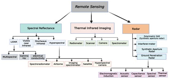
Figure 1.
Remote sensing methods and types in soil measurements.
RS is particularly beneficial in areas where soil samples are scarce or traditional sampling methods are impractical due to the terrain [19][70]. Furthermore, RS can provide data at various scales, ranging from individual fields to entire watersheds, facilitating a more extensive comprehension of soil variability. Remote sensors can offer high-resolution data across broad areas, mapping soil parameters such as organic carbon concentration and moisture content [20][71]. Hyperspectral RS has proven effective in accurately mapping soil properties and detecting erosion [21][72]. With the changes in land cover patterns, RS can identify erosion-prone areas and help implement soil conservation measures and land management strategies. However, in the case of an unmanned aerial vehicle (UAV) camera observing at nadir, the view zenith angle (VZA) was specified as 0°, as depicted in Figure 2. The VZA will move the sensor to the leading solar plane if the results are positive. Conversely, negative numbers indicate that the VZA is moving backward, with the sensor pointing away from the sun.
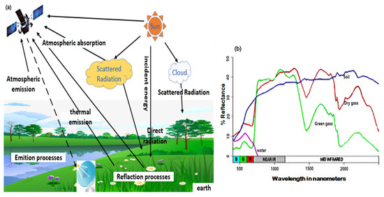
Figure 2.
Basic concept of remote sensing (
a
) Multi-angle remote sensing data acquisition processes (
b
) View zenith angle (VZA) time series reflect data.
On the upper left of the diagram, color bars beneath the UAV depict the four types of remotely sensed data. The data type directs scientists to the relevant data products, indicated by the circles on the right-hand side. The data output items are grouped based on their estimated delivery time. Some crucial measures rely on picture indices and do not require multiple image calibrations. The white circles on the left side of the diagram indicate data acquired at significant field sites for this inquiry. After spectral retrieval, additional analysis can be performed. The algorithms on the lower right require geographic information system (GIS) inputs to geolocate and register the picture to ground coordinates, which explores the extent to which geographic registration is possible in real time [22][73]. The schematic picture in Figure 3a indicates the process by which the satellite acquires a network via the UAV, which receives signals and acquires data from the field (agricultural field—soil and air) and reflects the base station where data is processed and transferred via the internet for interpretation and analysis (relevant data extraction, data consensus), and finally transmits data to the UAV for application to soil monitoring.
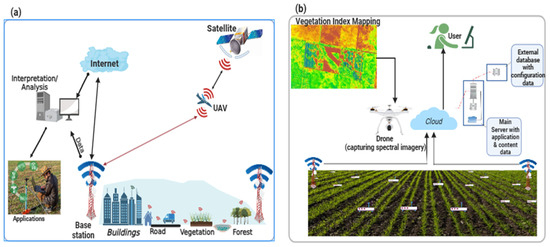
Figure 3.
Applications of remote sensing: (
a
) integrated UAV concepts; (
b
) remote sensing system operation.
Figure 3b illustrates a wireless sensor network system with multiple nodes. Each node comprises a soil moisture sensor to monitor water level, a soil temperature sensor, and air temperature and humidity sensors. In conclusion, RS methods offer valuable tools for assessing and monitoring soil properties. Spectral reflectance analysis provides insights into soil characteristics based on their unique spectral signatures. Thermal infrared imaging allows for estimates of soil moisture content, compaction levels, and fertility variations. Radar remote sensing enables the assessment of soil moisture content, surface roughness, and texture. These techniques contribute to a better understanding of soil dynamics and support informed decision-making in agriculture, land management, and environmental studies.
4. Remote Sensing Application in Soil Measurements
RS has emerged as a powerful tool for studying various soil properties, and its applications range from estimating soil moisture content and monitoring soil erosion to mapping soil organic carbon content and assessing soil salinity levels [23][5]. It involves acquiring of data from a distance, typically using satellite or airborne sensors, to gather information about soil properties [24][74]. These data can then be analyzed to extract meaningful insights about soil properties and their applications (Table 1). The applications of RS to soil properties are diverse and encompass several important aspects of soil science. For example, near-infrared reflectance can estimate vegetation cover and biomass production, while thermal infrared measurements can measure soil moisture content. By combining data from multiple wavelengths or sensors, reswearchers can better understand soil characteristics and their interactions with the environment [25][26][75,76]. It should be noted that by providing valuable insights into these soil properties, remote sensing contributes significantly to sustainable land management practices, agricultural productivity, and environmental conservation efforts.
Table 1.
Comparison of different remote sensing applications for soil measurements.
| Soil Property | Remote Sensing Methods | Descriptions | References |
|---|---|---|---|
| Soil Reflectance | Optical and multispectral imaging |
|
[27][77] |
| Soil Albedo | Optical and multispectral imaging |
|
[28][78] |
| Spectral Signatures | Spectral analysis, hyperspectral imaging |
|
[29][79] |
| Spectral Indices | Spectral analysis, multispectral imaging |
|
[30][80] |
| Soil Temperature | Thermal infrared imaging, thermal sensors |
|
[31][81] |
| Soil Moisture | Microwave RS, Thermal sensors |
|
[32][52] |
| Soil Roughness | Microwave remote sensing, LiDAR |
|
[33][43] |
| Soil Electrical Conductivity (EC) | Geophysical methods (EM, GPR) |
|
[34][82] |
| Soil Permeability | Geophysical methods (GPR) |
|
[35][40] |
| Soil Composition | Multispectral and hyperspectral imaging |
|
[36][83] |
| Vegetation Cover | Multispectral and hyperspectral imaging |
|
[37][33] |
| Soil Topography | LiDAR |
|
[38] |
| Soil Surface Characteristics | Radar imaging |
|
[39] |
| Change Detection | Multi-temporal analysis, radar, optical imagery |
|
[40][84] |
| Data Fusion and Integration | Integrating multiple remote sensing data |
|
[4][56] |
| Soil pH | Thermal infrared imaging, thermal sensors |
|
[41][15] |
In Table 1, the comparison of different RS methods used in soil measurements was examined and discussed, which covers several soil properties and describes the RS methods involved in the measurements. RS has shown valuable skill in monitoring daily or temporary soil characteristics, which change with time based on factors such as time of day, weather, season, and climate. Table 1 further shows that RS applications for soil measurements significantly advanced our understanding and offer valuable insight into soil processes, properties, erosion, moisture content, fertility, and other crucial factors influencing agricultural productivity and environmental management, such as spectral reflectance analysis, thermal infrared imaging, LiDAR, and hyperspectral imaging, which are critical techniques used in this field. Each technique has its strengths and limitations, and their selection depends on the study’s specific objectives and the desired level of detail required for soil analysis.
RS technology is a cost-effective and efficient tool for soil monitoring. It helps scientists and policymakers make informed decisions about agricultural practices, land use planning, and environmental conservation. Soil characteristics can be accurately detected and monitored via laboratory analysis and real-time measurements [3][4][55,56]. Due to the increasing demand for information, spectral responses can be utilized to evaluate surface and subsurface soil properties, but soil property monitoring techniques need updating [5][57]. Nevertheless, the benefits of remote sensing data in soil measurements far outweigh the limitations, making it an indispensable tool for soil scientists and environmental managers [42][45].
5. Remote Sensing Techniques in Soil Measurements
Remote sensing (RS) tools encompass many technologies and techniques that enable us to gather valuable data about the soil from a distance. Satellite-based tools offer global coverage and continuous monitoring capabilities (equipped with sensors that capture data in different wavelengths of the electromagnetic spectrum, including visible, infrared, and microwave) but have limitations regarding spatial resolution and cloud cover interference. In contrast, aerial-based tools provide higher spatial resolution for detailed mapping and monitoring of smaller areas but are limited by flight restrictions and higher costs (Table 2). Ground-based devices offer high-resolution data at close range and can provide detailed information about specific areas or objects of interest. Each type of remote sensing tool has its advantages and limitations, making them suitable for different applications and research needs.
Table 2.
Comparison of different remote sensing tools in soil measurements.
| Remote Sensing Tools | Advantages | Disadvantages | References | |||||||
|---|---|---|---|---|---|---|---|---|---|---|
| RS Method | Remote Sensor for Measuring Soil and Related Properties | Investigated Parameters | Applications | Highlights | References | |||||
| Satellite Imagery | Provides wide coverage, regular data capture, multispectral and hyperspectral capabilities for detailed analysis | Limited spatial resolution and control over data acquisition | [ | |||||||
| Hyperspectral Imaging | 43 | ] | Apparent Electrical Conductivity (ECa) (two sensors)[44] | Cation exchange capacity; organic carbon; electrical conductivity; Depth to argillic horizon[37,85] | ||||||
| The ECa of the two sensors should be compared. It is necessary to estimate a variety of soil properties. | The study improved soil properties estimation by combining ECa sensor fusion and data from various fields, with the highest R | 2 | predicted for the depth to the argillic horizon. | [ | 62][99] | Unmanned Aerial Vehicles (UAVs) and Drones | High-resolution imagery, offering flexibility in flight paths, cost effective for small-scale projects, and data acquisition timing | Limited coverage area and regulatory restrictions on flight altitude | [38][[ | |
| Reflectance Spectroscopy | ECa; Crop yield | 47 | pH; Calcium carbonate, elevation; stream power index; slope; organic carbon, wetness index; particle size distribution][3845][46],50,86,87] | |||||||
| To create a map of various soil properties and crop yield estimation, and determine variables for delineation management | The study found ECa was positively correlated with clay and negatively correlated with sand content, indicating field discrepancy. Landscape location and soil moisture were linked to management zones, and crop yields varied by management zone | [ | 63 | ] | [64][100,101] | LiDAR (Light Detection and Ranging) | Comprehensive data on topography, vegetation structure, canopy height high-resolution, 3D mapping capabilities and can penetrate vegetation cover | Expensive and limited penetration capabilities | [ | |
| Airborne LiDAR | 48 | ] | ECa (two sensors[49][88,89] | |||||||
| Sodium; Calcium, Potassium; Magnesium; Sulphur; Nitrogen; Phosphorus; cation exchange capacity; particle size distribution | soil pH; soluble salts (implied) | Determine the relationship between ECa and several soil characteristics | ECa was predicted in six research locations using clay content, silt content, soluble salts, Na, Ca, Mg, and CEC, with strong correlations with clay content and Mg in four fields | [65][102] | Thermal Imaging | Non-destructive, continuous monitoring measures soil temperature and moisture, identifying water stress and irrigation needs | Requires clear sky conditions for accurate temperature and limited to surface soil temperature monitoring | |||
| Electrochemical Sensor | Visible-Near Infrared spectra; ECa | [ | 31][50][81 | Organic Carbon; Electrical Conductivity; Carbon-to-Nitrogen ratio; Particle size distribution; Soil pH,90] | ||||||
| Multiple soil qualities were estimated | With an R | 2 | of 9.3 × 10 | −3, Visible/near-infrared spectra alone, ECa alone, and sensor fusion collectively produced the best soil property estimates | [44][66][85,103] | Soil Moisture Sensors | Accurate monitoring, directly measuring soil moisture content at different depths, providing real-time data and integration for continuous monitoring | Limited coverage area and requires physical installation in the soil | ||
| Electrochemical Sensor | Crop yield, Total carbon, Mechanical resistance; Capacitance probe; output voltage; Cone index | [ | 5][57] | |||||||
| Bulk density, Organic matter; Clay content | Multiple soil properties were estimated and mapped. Crop yield mapping | The study estimated sand content, silt, and clay content with the highest R | 2 | (0.90) at 0 to 28 cm from R, and found similar patterns in bulk density, mechanical resistance, and organic matter on crop yield maps | [67 | Hyperspectral imaging | High spectral resolution, improved detection, classification capabilities, enhanced data analysis, non-destructive and non-contact | Limited spatial coverage, high data processing, complexity, costly, limited availability and accessibility | [29][37][38][33,38,79] | |
| Ground-based remote sensing | High spatial resolution, real-time data collection, efficiency, and direct measures reflectance at different wavelengths to estimate soil composition and nutrient contents | Physical access to the soil surface can be challenging in certain terrains or land uses | [18][32][52,69] | |||||||
| [ | 18 | ] | [69] | |||||||
| ] | [ | 104 | ] | Radar system | Versatility, all-weather capability, depth perception, high resolution, large-scale coverage, long-distance capability, and ability to combine multiple radar measurements | Limited resolution, complexity, cost, limited spectral information, and interference | Infrared (IR) sensors | Non-contact, versatile application, fast and real-time data, wide coverage and high accuracy | Limited depth perception, influenced by environmental factors, limited penetration capability, cost, and limited spectral resolution | [50][51][90,91] |
| Optical sensors | High spatial resolution, multispectral capabilities, wide coverage, long-term data collection, and cost effective | Susceptibility to weather conditions, limited visibility, temporal resolution, limited data processing, and interpretation | [28][52][53][54][78,92,93,94] | |||||||
| Aerial Photography | High spatial resolution, flexibility, and rapid deployment | Limited coverage, weather dependency, and higher cost | [55][31] | |||||||
| Microwaves | Mapping vegetation, all-day operation, reliability, effectiveness, and obtaining data in adverse weather conditions | Lower spatial resolution, limited spectral information, reliance on active sensors, complex data interpretation, and limited availability of free data | [13][21][64,72] |
Based on Table 2 above, various remote sensing tools offer distinct benefits for measuring soil, as satellite-based remote sensing can provide global coverage and long-term monitoring but may not offer a detailed spatial resolution. On the other hand, airborne remote sensing provides higher spatial resolution and more detailed information but requires specialized equipment and is more expensive. Ground-based remote sensing tools offer direct measurements at close range with high spatial resolution but have a limited coverage area. Lidar remote sensing can give detailed information about topography and vegetation structure but comes with cost considerations. Ultimately, selecting the most suitable remote sensing tool will depend on the specific study objectives, the scale of analysis, and available resources.
RS techniques such as thermal, radar, hyperspectral, and optical sensors are used for soil analysis to detect the characteristics of objects and materials from a distance during soil property measurement [56][57][21,95]. Most detection modes depend on photons tested at their related electromagnetic (EM) frequency [58][96] because the frequency and force of energy reflected or transmitted by the highlights in the scene being detected are usually identified and recorded by distant sensors. It should be noted that the electromagnetic radiation spectrum (EMR) comprises particles that travel in waves, and visible light is the most visible form of electromagnetic magnetic radiation.
It is worth noting that mechanical sensors measuring soil penetration resistance are often used and combined with other sensors [59][60][61][42,97,98]. This is demonstrated in various studies on remote sensor measurements, as shown in Table 3, whose applications range from soil compaction assessment [62][99] to 3D modeling of soil layers.
Table 3.
Reviewed studies on remote sensors for measuring soil and related properties.
The platform’s altitude, the image’s spatial resolution, and the reduced return frequency for arranged sensors are the distinguishing factors for these platforms and imaging systems [68][105]. Calculating different soil properties can be a valuable tool for farmers, gardeners, and others who work with soil [69][106]. When analyzing temporal patterns in soil and plant properties, the frequency of data collection is a crucial factor to consider. However, it is essential to note that cloud cover can affect RS images from satellites and aerial platforms, although it has a more negligible impact on ground-based remote sensing [70][107]. Utilizing RS is an effective method for evaluating the surface characteristics of the ground from afar. This technique assesses the chemical and physical properties of the soil matrix by measuring the upwelling electromagnetic radiation emitted or reflected from the soil [71][108]. With the information obtained via RS, researchwers can distinguish differences between soil extrapolate characteristics and the soil surfaces from the radiation observed. RS technologies are widely acknowledged for providing a valuable tool for obtaining geographically and chronologically diverse information to assess soil properties accurately [72][109]. To account for geographically varying crop responses, information on soil variability may need to be coupled with plant information in both scenarios to improve in-season fertilization [55][56][73][21,31,32]. Understanding how things change over time is made more accessible by analyzing spatiotemporal changes. High-resolution tracking of spectral and spatial data changes is possible with the aid of RS. It can gain an understanding of how our environment changes because of its capacity to observe and track changes in great detail over time [74][110].