 +1 credit
| Version | Summary | Created by | Modification | Content Size | Created at | Operation |
|---|---|---|---|---|---|---|
| 1 | Jingjing Sun | -- | 1834 | 2023-06-15 06:35:07 | | | |
| 2 | Jingjing Sun | + 1638 word(s) | 3472 | 2023-06-15 08:41:39 | | | | |
| 3 | Lindsay Dong | Meta information modification | 3472 | 2023-06-15 11:27:07 | | | | |
| 4 | Jingjing Sun | -659 word(s) | 2813 | 2023-06-15 11:51:42 | | | | |
| 5 | Lindsay Dong | Meta information modification | 2813 | 2023-06-16 03:16:05 | | | | |
| 6 | Lindsay Dong | Meta information modification | 2813 | 2023-06-16 03:17:49 | | |
Video Upload Options
Wildfires are sudden and destructive natural hazards that pose significant challenges in response and relief efforts. Wildfires occur annually across the globe, influenced by factors such as climate, combustible materials, and ignition sources. In recent years, researchers have shown increasing interest in studying wildfires, resulting in a large number of related studies. These studies cover a variety of topics including wildfire forecasting and forecasting, spatial and temporal pattern analysis, ecological impact assessment, simulation of wildfire behavior, identification of contributing factors, development of risk assessment models, management techniques for combustible materials, firefighting decision-making techniques, and fire protection. burning method. Understanding the factors that influence wildfire spread behavior, employing modeling methods, and conducting risk assessments are critical for effective wildfire prevention, mitigation, and emergency response.
1. Introduction
2. Wildfire Spread Behavior and Risk Assessment System
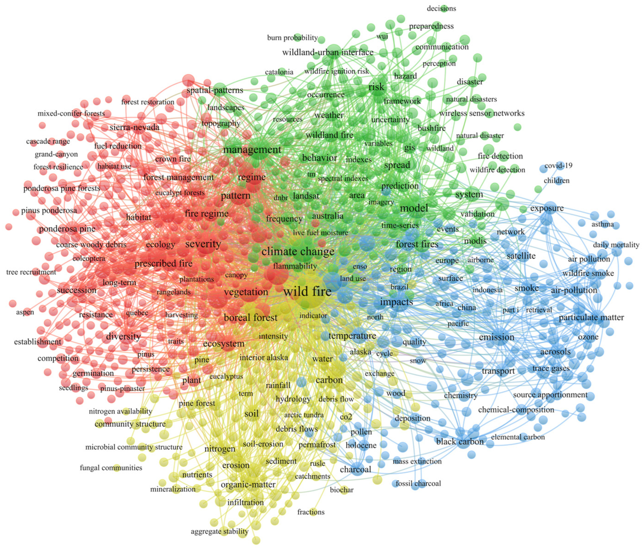
From Figure 1, it can be observed that the overall keywords related to forest fires/wildfires (referred to as “wildfires” collectively) are divided into four clusters. “Wildfires” are the most central and core term, located in the center of the network graph. In the red cluster on the left side, “severity”, “vegetation”, “fire regime”, and “diversity” are some of the typical keywords. In the literature, this cluster mainly represents research in the field of regional ecology, such as studies related to vegetation after wildfires [6][7]. In the yellow cluster below, “soil”, “rainfall”, “erosion”, and “organic-matter” are some representative keywords. The research direction of this cluster primarily focuses on the chemical changes in the environment (especially soil) after wildfires [8][9][10]. It also includes some concurrent disasters, such as rainfall and debris flows [11][12]. The blue cluster on the right side of the map includes representative keywords such as “impact”, “emission”, “smoke”, and “air pollution.” The research related to these keywords is mostly focused on the atmospheric environment field, such as studies on gas emissions and air pollution caused by fires [13][14][15][16].
2.1. Meteorological Factors
2.2. Combustible Factors
2.3. Topography Factors
2.4. Human Factors
3. Wildfire Spread Behavior Simulation Application
3.1. Simulation Application Based on Huygens’ Principle
3.1.1. Prometheus
3.1.2. FARSITE
3.1.3. FlamMap
3.2. Cellular Automata-Based Simulation Modeling
proposed a new fire spread modeling approach, LSSVM-CA, which combines the least squares support vector machine (LSSVM) with a three-dimensional wildfire CA framework and considers the effect of adjacent winds on fire spread patterns for analysis. To summarize the cases, the combination of wildfire spread visualization and the application system developed by meta-automata has become a popular and viable choice in simulating wildfire spread behavior.
4. Wildfire behavior risk assessment
4.1. Overview of Wildfire Risk Assessment
The wildfire risk assessment method based on wildfire prediction has high accuracy and is greatly affected by weather forecast factors. They are suitable for medium size ranges. On the other hand, the method of establishing a risk index for wildfire risk assessment takes into account a variety of factors and is more suitable for macro-level applications. Methods based on information diffusion theory are more suitable for analyzing small samples due to their inherent characteristics. In recent years, with the rapid development of scientific and technological capabilities, comprehensive wildfire risk assessment using "3S" technology and wildfire risk assessment based on deep learning have been widely used. However, they require strict data accuracy. The accuracy of wildfire risk assessment method and wildfire spread behavior simulation based on wildfire behavior influencing factors is high.
4.2. Wildfire Risk Assessment Based on Wildfire Spread Behavior
4.2.1.Wildfire Risk Assessment Based on Influencing Factors
4.2.2.Behavior-Based Simulation for Wildfire Risk Assessment
References
- Arif, M.; Alghamdi, K.; Sahel, S.; Alosaimi, S.; Alsahaft, M.; Alharthi, M.; Arif, M. Role of machine learning algorithms in forest fire management: A literature review. J. Rob. Autom. 2021, 5, 212–226.
- Boer, M.M.; Resco de Dios, V.; Bradstock, R.A. Unprecedented burn area of Australian mega forest fires. Nat. Clim. Chang. 2020, 10, 171–172.
- Finney, M.A. The challenge of quantitative risk analysis for wildland fire. For. Ecol. Manag. 2005, 211, 97–108.
- Du, J.; Wang, K.; Cui, B. Attribution of the extreme drought-related risk of wildfires in spring 2019 over southwest China. Bull. Am. Meteorol. Soc. 2021, 102, S83–S90.
- Feng, H. Exploration and thinking on related mechanisms of forest fire prevention. In Proceedings of the 2021 International Conference on Social Science: Public Administration, Law and International Relations (SSPALIR 2021), Moscow, Russia, 16–17 June 2021; pp. 13–18.
- Tian, X.; Dai, X.; Wang, M.; Zhao, F.; Shu, L. Forest fire risk assessment for China under different climate scenarios. Chin. J. Appl. Ecol. 2016, 27, 769–776.
- Halofsky, J.E.; Peterson, D.L.; Harvey, B.J. Changing wildfire, changing forests: The effects of climate change on fire regimes and vegetation in the Pacific northwest, USA. Fire Ecol. 2020, 16, 4.
- De la Rosa, J.M.; Faria, S.R.; Varela, M.E.; Knicker, H.; González-Vila, F.J.; González-Pérez, J.A.; Keizer, J. Characterization of wildfire effects on soil organic matter using analytical pyrolysis. Geoderma 2012, 191, 24–30.
- Moody, J.A.; Martin, D.A.; Cannon, S.H. Post-wildfire erosion response in two geologic terrains in the western USA. Geomorphology 2008, 95, 103–118.
- Shakesby, R. Post-wildfire soil erosion in the Mediterranean: Review and future research directions. Earth-Sci. Rev. 2011, 105, 71–100.
- Hoch, O.J.; McGuire, L.A.; Youberg, A.M.; Rengers, F.K. Hydrogeomorphic recovery and temporal changes in rainfall thresholds for debris flows following wildfire. J. Geophys. Res. Earth Surf. 2021, 126, e2021JF006374.
- Touma, D.; Stevenson, S.; Swain, D.L.; Singh, D.; Kalashnikov, D.A.; Huang, X. Climate change increases risk of extreme rainfall following wildfire in the western United States. Sci. Adv. 2022, 8, eabm0320.
- Hu, Y.; Zhan, J.; Zhou, G.; Chen, A.; Cai, W.; Guo, K.; Hu, Y.; Li, L. Fast forest fire smoke detection using MVMNet. Knowl.-Based Syst. 2022, 241, 108219.
- Knorr, W.; Dentener, F.; Lamarque, J.-F.; Jiang, L.; Arneth, A. Wildfire air pollution hazard during the 21st century. Atmos. Chem. Phys. 2017, 17, 9223–9236.
- Urbanski, S. Wildland fire emissions, carbon, and climate: Emission factors. For. Ecol. Manag. 2014, 317, 51–60.
- Zhan, J.; Hu, Y.; Zhou, G.; Wang, Y.; Cai, W.; Li, L. A high-precision forest fire smoke detection approach based on ARGNet. Comput. Electron. Agric. 2022, 196, 106874.
- Van Leeuwen, W.J.; Casady, G.M.; Neary, D.G.; Bautista, S.; Alloza, J.A.; Carmel, Y.; Wittenberg, L.; Malkinson, D.; Orr, B.J. Monitoring post-wildfire vegetation response with remotely sensed time-series data in Spain, USA and Israel. Int. J. Wildland Fire 2010, 19, 75–93.
- Moody, J.A.; Martin, D.A.; Cannon, S.H. Post-wildfire erosion response in two geologic terrains in the western USA. Geomorphology 2008, 95, 103–118.
- Knorr, W.; Dentener, F.; Lamarque, J.-F.; Jiang, L.; Arneth, A. Wildfire air pollution hazard during the 21st century. Atmos. Chem. Phys. 2017, 17, 9223–9236.
- Zhan, J.; Hu, Y.; Zhou, G.; Wang, Y.; Cai, W.; Li, L. A high-precision forest fire smoke detection approach based on ARGNet. Comput. Electron. Agric. 2022, 196, 106874.
- Banerjee, T.; Heilman, W.; Goodrick, S.; Hiers, J.K.; Linn, R. Effects of canopy midstory management and fuel moisture on wildfire behavior. Sci. Rep. 2020, 10, 17312.
- Radeloff, V.C.; Helmers, D.P.; Kramer, H.A.; Mockrin, M.H.; Alexandre, P.M.; Bar-Massada, A.; Butsic, V.; Hawbaker, T.J.; Martinuzzi, S.; Syphard, A.D. Rapid growth of the US wildland-urban interface raises wildfire risk. Proc. Natl. Acad. Sci. USA 2018, 115, 3314–3319.
- Radke, D.; Hessler, A.; Ellsworth, D. FireCast: Leveraging deep learning to predict wildfire spread. In Proceedings of the Twenty-Eighth International Joint Conference on Artificial Intelligence, Macao, China, 10–16 August 2019; pp. 4575–4581.
- Pausas, J.G.; Keeley, J.E. Wildfires and global change. Front. Ecol. Environ. 2021, 19, 387–395.
- Zhang, G.; Wang, M.; Liu, K. Forest fire susceptibility modeling using a convolutional neural network for Yunnan province of China. Int. J. Disaster Risk Sci. 2019, 10, 386–403.
- Guo, F.; Wang, G.; Su, Z.; Liang, H.; Wang, W.; Lin, F.; Liu, A. What drives forest fire in Fujian, China? Evidence from logistic regression and Random Forests. Int. J. Wildland Fire 2016, 25, 505–519.
- Hurteau, M.D.; Bradford, J.B.; Fulé, P.Z.; Taylor, A.H.; Martin, K.L. Climate change, fire management, and ecological services in the southwestern US. For. Ecol. Manag. 2014, 327, 280–289.
- Westerling, A.L.; Hidalgo, H.G.; Cayan, D.R.; Swetnam, T.W. Warming and earlier spring increase western US forest wildfire activity. Science 2006, 313, 940–943.
- Tariq, A.; Shu, H.; Siddiqui, S.; Mousa, B.; Munir, I.; Nasri, A.; Waqas, H.; Lu, L.; Baqa, M.F. Forest fire monitoring using spatial-statistical and Geo-spatial analysis of factors determining forest fire in Margalla Hills, Islamabad, Pakistan. Geomat. Nat. Hazards Risk 2021, 12, 1212–1233.
- Ruan, J.; Li, J. Research progress on two-way fire-wind coupling simulation in forest fire spread. Mod. C. 2021, 37–42.
- Keeley, J.E. Fire intensity, fire severity and burn severity: A brief review and suggested usage. Int. J. Wildland Fire 2009, 18, 116–126.
- Chen, M.; Du, J.; Wang, W.; Yu, H.; Wang, B.; Gu, Z.; Liu, X. Characteristics and potential fire behavior of combustibles in the canopy of Pinus tabuliformis forest in Badaling Forest Farm of Beijing. J. Beijing For. Univ. 2022, 44, 55–64.
- Deeming, J.E.; Brown, J.K. Fuel models in the national fire-danger rating system. J. For. 1975, 73, 347–350.
- Hoffman, C.; Canfield, J.; Linn, R.; Mell, W.; Sieg, C.; Pimont, F.; Ziegler, J. Evaluating crown fire rate of spread predictions from physics-based models. Fire Technol. 2016, 52, 221–237.
- Wu, Z.; Wang, B.; Li, M.; Tian, Y.; Quan, Y.; Liu, J. Simulation of forest fire spread based on artificial intelligence. Ecol. Indic. 2022, 136, 108653.
- Ganteaume, A.; Camia, A.; Jappiot, M.; San-Miguel-Ayanz, J.; Long-Fournel, M.; Lampin, C. A review of the main driving factors of forest fire ignition over Europe. Environ. Manag. 2013, 51, 651–662.
- Xu, W.; Wu, C.; Yang, L.; Xu, S.; Qing, M.; Wang, Q. Comparative study on surface litter load and fireintensity of Pinus armandii and Pinus yunnanensis in northeastern Yunnan Province. J. Southwest For. Coll. 2019, 39, 151–156.
- Zhou, F.; Pan, H.; Gao, Z.; Huang, X.; Qian, G.; Zhu, Y.; Xiao, F. Fire prediction based on catboost algorithm. Math. Probl. Eng. 2021, 2021, 1929137. [Google Scholar] [CrossRef]
- Kannan, M.; Saranathan, E.; Anbalagan, R. Comparative analysis in GIS-based landslide hazard zonation—A case study in Bodi-Bodimettu Ghat section, Theni District, Tamil Nadu, India. Arab. J. Geosci. 2015, 8, 691–699.
- Li, W.; Xu, Q.; Yi, J.; Liu, J. Predictive model of spatial scale of forest fire driving factors: A case study of Yunnan Province, China. Sci. Rep. 2022, 12, 19029.
- Dupuy, J.-L.; Maréchal, J.; Portier, D.; Valette, J.-C. The effects of slope and fuel bed width on laboratory fire behaviour. Int. J. Wildland Fire 2011, 20, 272–288.
- Gralewicz, N.J.; Nelson, T.A.; Wulder, M.A. Factors influencing national scale wildfire susceptibility in Canada. For. Ecol. Manag. 2012, 265, 20–29.
- Rodrigues, M.; Jiménez, A.; de la Riva, J. Analysis of recent spatial–temporal evolution of human driving factors of wildfires in Spain. Nat. Hazards 2016, 84, 2049–2070.
- Pereira, M.; Malamud, B.; Trigo, R.; Alves, P. The history and characteristics of the 1980–2005 Portuguese rural fire database. Nat. Hazards Earth Syst. Sci. 2011, 11, 3343–3358.
- Wang, M.; Xu, Y.; Zhao, M. Spatio-temporal distribution pattern and cause analysis of forest fires in my country in recent 10 years. Bull. Agric. Sci. Technol. 2021, 201–204.
- Anderson, D.; Catchpole, E.; De Mestre, N.; Parkes, T. Modelling the spread of grass fires. Anziam J. 1982, 23, 451–466.
- Lee, B.; Alexander, M.; Hawkes, B.; Lynham, T.; Stocks, B.; Englefield, P. Information systems in support of wildland fire management decision making in Canada. Comput. Electron. Agric. 2002, 37, 185–198.
- Tymstra, C.; Bryce, R.; Wotton, B.; Taylor, S.; Armitage, O. Development and structure of Prometheus: The Canadian Wildland fire Growth Simulation Model. In Natural Resources Canada, Canadian Forest Service, Northern Forestry Centre, Information Report NOR-X-417; Canadian Forest Service Publications: Edmonton, AB, Canada, 2010.
- Finney, M.A. FARSITE, Fire Area Simulator—Model Development and Evaluation; US Department of Agriculture, Forest Service, Rocky Mountain Research Station: Fort Collins, CO, USA, 1998.
- Finney, M.A.; Andrews, P.L. FARSITE—A program for fire growth simulation. Fire Manage. Fire Manag. Notes 1999, 59, 13–15.
- Finney, M.A. An overview of FlamMap fire modeling capabilities. In Fuels Management—How to Measure Success: Conference Proceedings; USDA Forest Service, Rocky Mountain Research Station: Fort Collins, CO, USA, 2006; p. 30.
- Finney, M.A. Fire growth using minimum travel time methods. Can. J. For. Res. 2002, 32, 1420–1424.
- Vilà-Vilardell, L.; Keeton, W.S.; Thom, D.; Gyeltshen, C.; Tshering, K.; Gratzer, G. Climate change effects on wildfire hazards in the wildland-urban-interface–Blue pine forests of Bhutan. For. Ecol. Manag. 2020, 461, 117927.
- Mitsopoulos, I.; Mallinis, G.; Zibtsev, S.; Yavuz, M.; Saglam, B.; Kucuk, O.; Bogomolov, V.; Borsuk, A.; Zaimes, G. An integrated approach for mapping fire suppression difficulty in three different ecosystems of eastern Europe. J. Spat. Sci. 2017, 62, 139–155.
- Almeida, R.M.; Macau, E.E. Stochastic cellular automata model for wildland fire spread dynamics. In Journal of Physics: Conference Series; IOP Publishing: Bristol, UK, 2011; p. 012038.
- Sullivan, A.; Knight, I. A hybrid cellular automata/semi-physical model of fire growth. In Proceedings of the Engineering of Complex Computer Systems, Florence, Italy, 14–16 April 2004; pp. 64–73.
- Mutthulakshmi, K.; Wee, M.R.E.; Wong, Y.C.K.; Lai, J.W.; Koh, J.M.; Acharya, U.R.; Cheong, K.H. Simulating forest fire spread and fire-fighting using cellular automata. Chin. J. Phys. 2020, 65, 642–650.
- Rui, X.; Hui, S.; Yu, X.; Zhang, G.; Wu, B. Forest fire spread simulation algorithm based on cellular automata. Nat. Hazards 2018, 91, 309–319.
- Xu, Y.; Li, D.; Ma, H.; Lin, R.; Zhang, F. Modeling forest fire spread using machine learning-based cellular automata in a GIS environment. Forest 2022, 13, 1974.
- Carmel, Y.; Paz, S.; Jahashan, F.; Shoshany, M. Assessing fire risk using Monte Carlo simulations of fire spread. For. Ecol. Manag. 2009, 257, 370–377.

