Wildfires are sudden and destructive natural hazards that pose significant challenges in response and relief efforts. Wildfires occur annually across the globe, influenced by factors such as climate, combustible materials, and ignition sources. In recent years, researchers have shown increasing interest in studying wildfires, resulting in a large number of related studies. These studies cover a variety of topics including wildfire forecasting and forecasting, spatial and temporal pattern analysis, ecological impact assessment, simulation of wildfire behavior, identification of contributing factors, development of risk assessment models, management techniques for combustible materials, firefighting decision-making techniques, and fire protection. burning method. Understanding the factors that influence wildfire spread behavior, employing modeling methods, and conducting risk assessments are critical for effective wildfire prevention, mitigation, and emergency response.野火是一种突发且极具破坏性的自然灾害,在响应和救援工作方面带来了重大挑战。受气候、可燃材料和点火源等因素的影响,野火在全球范围内每年都在发生。近年来,研究人员对研究野火表现出越来越大的兴趣,导致了大量的相关研究。这些研究涵盖了各种主题,包括野火预测和预报,空间和时间模式分析,生态影响评估,野火行为模拟,影响因素的识别,风险评估模型的开发,可燃材料的管理技术,消防决策技术和阻燃方法。了解影响野火蔓延行为的因素、采用模拟方法和进行风险评估对于有效的野火预防、减灾和应急响应至关重要。
- wildfire spread
- driving factors
- simulation
- risk assessment
- wildfire
1. Introduction
2. Wildfire Spread Behavior and Risk Assessment System
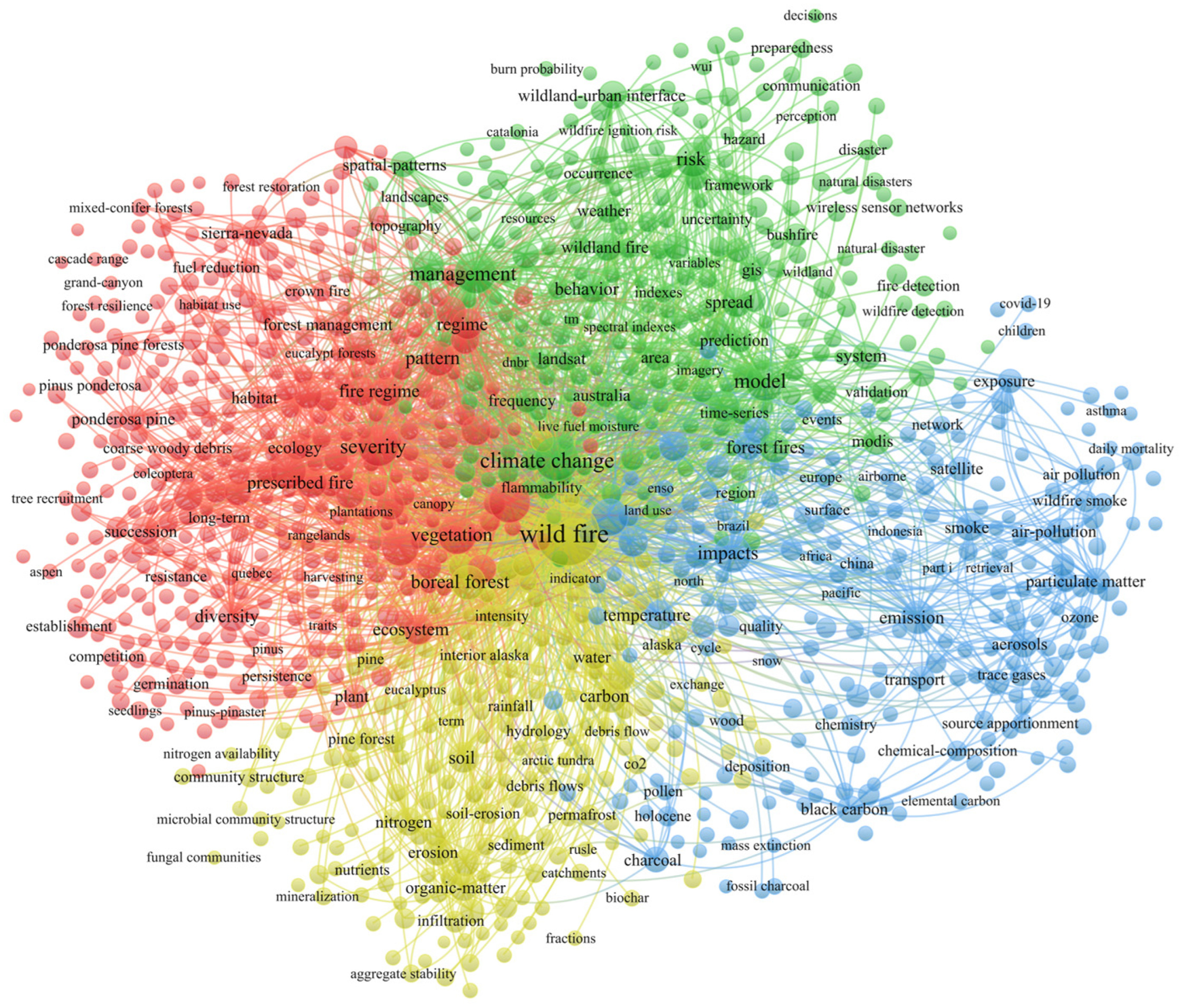
From Figure 1, it can be observed that the overall keywords related to forest fires/wildfires (referred to as “wildfires” collectively) are divided into four clusters. “Wildfires” are the most central and core term, located in the center of the network graph. In the red cluster on the left side, “severity”, “vegetation”, “fire regime”, and “diversity” are some of the typical keywords. In the literature, this cluster mainly represents research in the field of regional ecology, such as studies related to vegetation after wildfires [6][7][23,24]. In the yellow cluster below, “soil”, “rainfall”, “erosion”, and “organic-matter” are some representative keywords. The research direction of this cluster primarily focuses on the chemical changes in the environment (especially soil) after wildfires [8][9][10][25,26,27]. It also includes some concurrent disasters, such as rainfall and debris flows [11][1[28,2]9]. The blue cluster on the right side of the map includes representative keywords such as “impact”, “emission”, “smoke”, and “air pollution.” The research related to these keywords is mostly focused on the atmospheric environment field, such as studies on gas emissions and air pollution caused by fires [1[3][0,314][15][16],32,33].
2.1. Meteorological Factors
In recent years, many forest ecosystems have undergone changes due to the influence of global climate warming [27][44]. As a result, the occurrence of wildfires has been influenced, with climate change contributing to an increase in both the frequency and intensity of wildfires [28][45]. Among the meteorological factors, wind speed and wind direction play crucial roles in influencing the spread of wildfires. Wind speed significantly affects the duration of a fire, influencing its spread rate and coverage. Under the combined influence of wind speed and wind direction, the efficiency of heat transfer and the real-time rate of fire spread are directly impacted [29][46]. Wind accelerates the spread of wildfires through several pathways: (1) Wind can accelerate the drying of fuel, providing sufficient oxygen and dry fuel within the burning area, which serves as the medium for the occurrence of wildfires and accelerates their spread. (2) Unburned fuel within the forest can be ignited more rapidly under the influence of wind, leading to an accelerated spread of wildfires to surrounding areas. Due to it carrying capacity, wind can transport embers generated during the forest burning process to other unburned areas, resulting in new ignition points at the periphery of the fire, this phenomenon is known as spotting. Spotting makes it easier for the wildfire to rapidly expand its range of spread [30][47]. (3) Altering the spatial distribution pattern of fuel can greatly affect the rate of wildfire spread. For example, increasing fuel density or changing the orientation of flammable materials can have a significant impact on the spread rate of wildfires [31][48].2.2. Combustible Factors
Fuel is the material basis for the occurrence and combustion of wildfires [32][52]. Macroscopically, fuels can be classified into live fuels and dead fuels based on their vitality [33][53]. Here, live fuels refer to vegetation. As of September 2022, according to the resource inventory data released by the National Forestry and Grassland Administration, China’s forest coverage rate has reached 24.02%, with a forest area of 331 million hectares. China’s grassland area is 392.8 million hectares, accounting for 40.90% of the total land area. Due to variations in geographical locations, vegetation exhibits variations in coverage, area, density, structure, and chemical composition. Consequently, different vegetation types have varying ignition points and burning rates to some extent [34][35][54,55]. Research has shown that the occurrence of wildfires follows certain patterns, adhering to typical time patterns determined by environmental conditions and vegetation phenology cycles. The time span can vary from one day to one year [36][56]. Dead fuel primarily refers to litter or dead vegetation material [37][57]. Surface litter, with its low density, is the most effective fuel during wildfire combustion. Its impact on fire occurrence is primarily due to the larger gaps between materials, which provide ample oxygen storage as a crucial combustion medium.2.3. Topography Factors
Basic topographic factors that affect wildfire spread include elevation, slope, and aspect. All three factors are considered static variables [38][59]. The impact of topography on wildfire spread rate can be observed in the following aspects: (1) Elevation is an important factor influencing wildfire spread. Different ecological conditions exist at different elevations. Higher elevations are associated with lower temperatures, lower humidity, higher relative humidity, and higher plant moisture content, which reduces the likelihood of ignition. In contrast, lower elevations have lower plant moisture content and are more susceptible to burning [39][40][60,61]. (2) The impact of slope on wildfires is manifested in its effect on the moisture content of combustible materials. Different slopes have varying durations of rainfall retention, which in turn affects the moisture content of combustible materials. Steeper slopes allow less time for rainfall to stay on the slope, resulting in a quicker drying of combustible materials under the combined influence of temperature and wind after rainfall. This increases the likelihood of fire occurrence. On the other hand, gentle slopes retain a higher percentage of rainfall, which increases the moisture content in combustible materials and reduces the probability and potential for wildfires. Additionally, changes in slope alter the spatial relationship between the burning surface of the wildfire and unburned combustible materials, thereby influencing the spread rate of the wildfire. Generally, uphill and steep slopes exhibit faster spread rates, while downhill and gentle slopes exhibit slower spread rates, although the impact is relatively weaker [41][42][62,63]. (3) The impact of aspect on the spread rate of wildfires refers to the influence of solar exposure. Sun-facing slopes (southern or western aspects in the Northern Hemisphere) receive stronger solar radiation, resulting in lower humidity and relatively dry microclimatic conditions.2.4. Human Factors
The majority of wildfires currently occurring are caused by human factors [43][65]. Human factors have both positive and negative impacts on wildfires. On one hand, population density directly influences the occurrence of wildfires. Human activities frequently occur in wildland areas, increasing the likelihood of intentional or accidental ignition sources and, consequently, elevating the risk of wildfire spread. High population density in wildland areas increases the likelihood of such ignition sources [44][66]. According to data from the National Bureau of Statistics of China, there was a decrease in the number of wildfires from 8859 in 2009 to 2034 in 2016. One of the reasons for this decline is the implementation of the “Forest Fire Prevention Regulations” in 2009, which essentially prohibited outdoor fires [45][67].3. Wildfire Spread Behavior Simulation Application
3.1. Simulation Application Based on Huygens’ Principle
Huygens’ principle [46][78] on the process of wildfire spread is illustrated in Figure 2. Wildfire spread behavior is a complex process involving the interaction of multiple factors. Around the fire scene, each control point is considered as an independent ignition point influenced by external factors such as wind direction, wind speed, and terrain. These factors affect the rate and direction of fire propagation, thereby determining the spread boundary of the fire scene. Typically, the spread boundary of a fire scene presents an elliptical shape, forming an elliptical fire perimeter.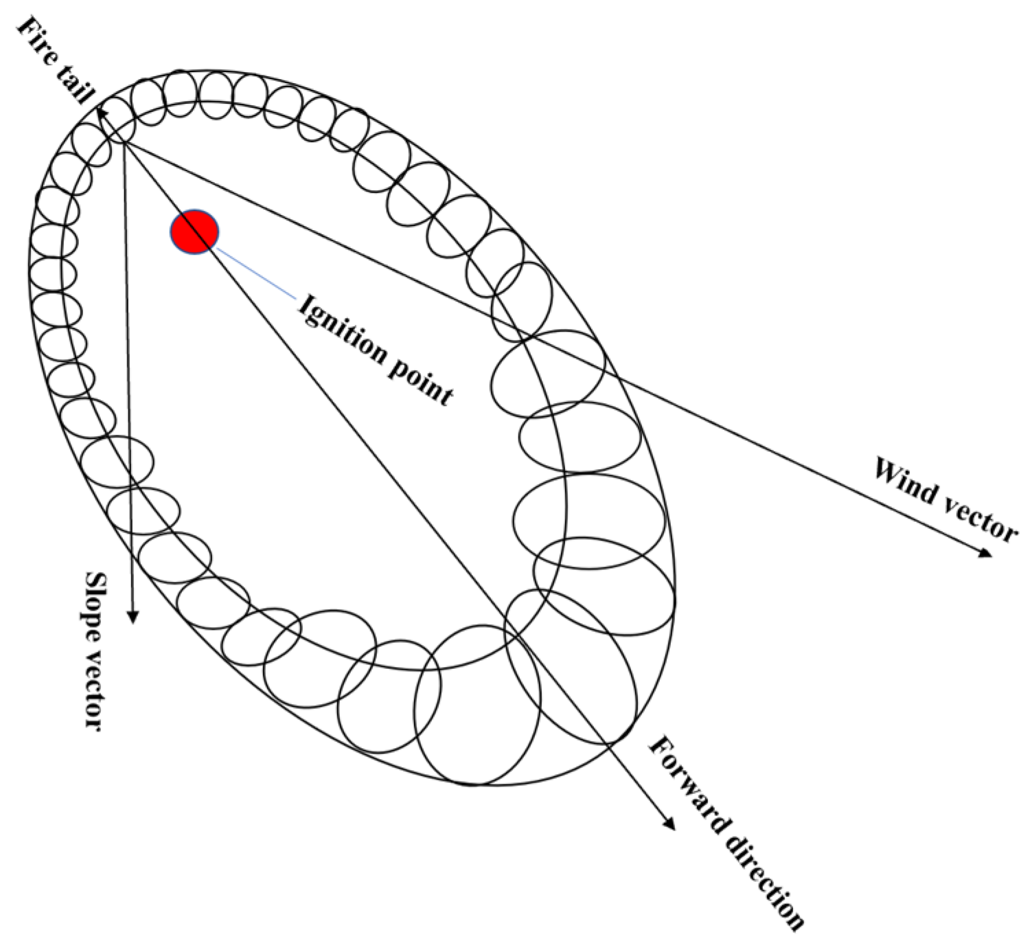
3.1.1. Prometheus
3.1.2. FARSITE
3.1.3. FlamMap
FlamMap is a landscape-level application simulation program that integrates fire behavior modeling, fuel management, and map visualization. It is capable of simulating potential fire behavior characteristics, such as spread rate, flame length, and fire intensity. Additionally, it can simulate fire growth and spread, as well as conditional burning probability, under constant environmental conditions such as weather and fuel moisture. FlamMap combines various aspects of fire analysis, allowing for a comprehensive assessment and prediction of fire behavior in a given landscape [51][93]. Burning probabilities and fire sizes in FlamMap are calculated using the Minimum Travel Time fire growth algorithm (MTT), which was developed by Finney[94] [52] and has been widely used in spatial fire behavior modeling studies worldwide [53][54][95,96].3.2. Cellular Automata-Based Simulation Modeling
Cellular Automaton (CA) is a dynamic system that can simulate spatial and temporal characteristics. In the process of fire spread, fuel and terrain conditions are assumed to be uniform within each cell, and fire propagates on a grid-based on each cell. CA is a grid-based dynamic model that follows certain causal relationships [55][98]. CA is easily integrated with digital data from Geographic Information Systems (GIS) or other sources to generate applications for specific environments. Table 2 provides specific information on applications based on the CA framework. Sullivan and Knight [99]et al. [56] developed a hybrid two-dimensional meta-automata model system with convective-wind interactions, which spread application is based on a meta-automata spread approach and a semi-physical model of thermal convection to simulate wildfire spread boundaries during wildfire occurrence. The application used in Mutthulakshmi's [100]study [57] was based on the CA framework, which was improved and optimized to simulate wildfire spread, analyzing the factors that influence fire spread and determining which factors play a key role in the spread of wildfires Rui [58] [101]constructed an improved model system that couples a meta-cellular automaton with an existing wildfire model. The system considered the effect of time step on simulation accuracy to provide optimal time step values with high temporal and spatial consistency. Xu [59].[102]proposed a new fire spread modeling approach, LSSVM-CA, which combines the least squares support vector machine (LSSVM) with a three-dimensional wildfire CA framework and considers the effect of adjacent winds on fire spread patterns for analysis. To summarize the cases, the combination of wildfire spread visualization and the application system developed by meta-automata has become a popular and viable choice in simulating wildfire spread behavior.
4. Wildfire behavior risk assessment
4.1. Overview of Wildfire Risk Assessment
The wildfire risk assessment method based on wildfire prediction has high accuracy and is greatly affected by weather forecast factors. They are suitable for medium size ranges. On the other hand, the method of establishing a risk index for wildfire risk assessment takes into account a variety of factors and is more suitable for macro-level applications. Methods based on information diffusion theory are more suitable for analyzing small samples due to their inherent characteristics. In recent years, with the rapid development of scientific and technological capabilities, comprehensive wildfire risk assessment using "3S" technology and wildfire risk assessment based on deep learning have been widely used. However, they require strict data accuracy. The accuracy of wildfire risk assessment method and wildfire spread behavior simulation based on wildfire behavior influencing factors is high.
4.2. Wildfire Risk Assessment Based on Wildfire Spread Behavior
4.2.1.Wildfire Risk Assessment Based on Influencing Factors
From the preceding discussion it is evident that wildfire risk assessments are designed to take into account various factors including weather, topography, fuel and human factors. Predicting and assessing the main drivers of wildfire spread provides a scientific basis for dynamic fire management and prevention. An in-depth study of fire drivers provides insight into the potential paths, speed and intensity of fire spread. This awareness enables resource allocation, firefighting strategies, early warning systems, and emergency evacuation measures to minimize potential hazards to individuals, property, and the environment, and to protect the ecological environment and human safety.4.2.2.Behavior-Based Simulation for Wildfire Risk Assessment
Wildfire risk assessment based on historical fire ignition data combined with fire spread influencing factors or fire spread models is a highly accurate and precise method. By simulating wildfire spread behavior, it is possible to predict the speed, direction, and extent of fire propagation, thus quantitatively assessing the level of wildfire risk. Carmel et al. [60][114] created a distribution map of wildfires in Mount Carmel, Israel, covering 20 years of historical fire data. They generated Monte Carlo simulations for fire spread based on these data and used FARSITE software (FlamMap includes FARSITE, currently does not support separate download) to simulate fire spread for 500 fire points. This approach provided a long-term strategic plan for fire prevention activities in the area.5. Conclusion and Prospect
In recent years, there has been significant progress in the research of wildfire spread behavior. This paper aims to systematically construct a wildfire spread behavior and risk assessment system based on a dataset of 20,000 papers from the Web of Science (WOS) core database. Through an analysis using VOSviewer (V_1.6.19), it is evident that the research on wildfire spread behavior and risk assessment is closely related and represents important components of the wildfire research field. Based on this foundation, the paper summarizes the impacts of meteorological, topographical, combustible, and human factors on wildfire spread behavior. Additionally, it provides a brief description of several commonly used software applications for simulating fire spread processes and discusses the selection of data for simulation using this software. Moreover, the paper provides a comprehensive overview of various methods for wildfire spread behavior risk assessment, with a particular focus on two risk assessment methods based on wildfire spread behavior influencing factors and simulation.
This study serves as a valuable reference for wildfire prevention and emergency decision-making. However, it acknowledges the need for further in-depth research in certain areas. The paper suggests that future research should concentrate on the dynamic monitoring of wildfire spread behavior, quantitative analysis of wildfire spread behavior and driving factors, development of wildfire spread behavior simulation algorithms and software, as well as wildfire spread behavior risk assessment.
(1) Enhancing research on dynamic monitoring of wildfire spread behavior is crucial. The key to firefighting is early detection and early resolution. Dynamic monitoring serves as an important foundation for emergency management when wildfires are approaching or just starting, as it can minimize disaster losses and enhance disaster prevention and mitigation capabilities. The data required for wildfire monitoring encompass various aspects, such as fire front position, fire extent, fire tracking, and other monitoring measures. The accuracy of these data directly impacts the effectiveness of monitoring efforts and the ability to reduce losses. In recent years, China has launched multiple domestically developed high-resolution remote sensing satellites and Beidou Navigation Satellites. However, each satellite has its own strengths and limitations. Therefore, it is imperative to explore methods for integrating and utilizing multi-source satellite data in a complementary and coordinated manner to maximize practical applications. Furthermore, it is essential to address the timely, efficient, and accurate communication of monitoring information, particularly during abnormal weather conditions. Developing effective communication channels and systems to disseminate monitoring information to relevant stakeholders is crucial for facilitating prompt decision-making and response actions.
(2) The study of driving factors of wildfires has gained significant attention, and it is crucial to identify and quantify the relationship between wildfires and these driving factors for global wildfire research. Wildfire spread behavior exhibits various characteristics, such as the extent and intensity of fire spread. It is also worth researching and discussing which specific driving factors have a greater impact on these characteristics. Additionally, it is worth exploring whether the driving factors at regional and local scales during wildfire spread exhibit uniformity or significant differences, which is another topic worthy of discussion.
(3) In the current context, due to spatial heterogeneity, most wildfire spread modeling software focuses on specific scenarios and environments, making them less applicable to a wide range of environments and unsuitable for broad-scale implementation. Therefore, in future research, it is important to prioritize the comprehensiveness of the models. For example, incorporating wildfire visualization into wildfire spread models can be explored. On the other hand, since wildfire spread models originated from overseas, many of the parameters in these models are not applicable to the forest conditions in China. In recent years, thanks to the continuous efforts of domestic experts and scholars, wildfire spread models in China have been improving and maturing. In future research, it is necessary to gradually establish accurate and mature wildfire spread models specific to China and develop application software that simulates wildfire spread behavior suitable for China's context.
(4) For wildfire risk assessment, each assessment method has its own applicable environment. The introduction of scientific remote sensing technology and the concepts and techniques of geographic information systems (GIS) has led to significant progress in wildfire spatial data processing and analysis of wildfire spread. These advancements have further facilitated the assessment of wildfire risk at the landscape scale. In future research, the primary focus should be on utilizing 3S technology (Remote Sensing, GIS, and GPS) and deep learning techniques, supplemented by other methods, to achieve a comprehensive and accurate assessment of wildfire spread. This approach will result in more intuitive and scientifically sound outcomes. In summary, conducting precise and scientific wildfire risk assessment can effectively guide relevant departments in implementing sound fire prevention measures, thereby reducing the occurrence of large-scale wildfires and protecting various resources and ecosystems more effectively.