野火是一种突发且极具破坏性的自然灾害,在响应和救援工作方面带来了重大挑战。受气候、可燃材料和点火源等因素的影响,野火在全球范围内每年都在发生。近年来,研究人员对研究野火表现出越来越大的兴趣,导致了大量的相关研究。这些研究涵盖了各种主题,包括野火预测和预报,空间和时间模式分析,生态影响评估,野火行为模拟,影响因素的识别,风险评估模型的开发,可燃材料的管理技术,消防决策技术和阻燃方法。了解影响野火蔓延行为的因素、采用模拟方法和进行风险评估对于有效的野火预防、减灾和应急响应至关重要。
1. Introduction
Wildfire is a common natural disaster, characterized by the uncontrolled spread and propagation of fire. These wildfires exhibit suddenness, high uncertainty, and significant hazards, resulting in the severe loss of forest resources and damage to natural ecosystems [
1]. Notably, in 2020, Australia witnessed the largest recorded forest fire in history, lasting several months and scorching approximately 11.46 million hectares of forest, causing irreparable ecological damage [
2,
3]. Similarly, in 2019, Muli County, Liangshan Prefecture, Sichuan Province, experienced a forest fire that rapidly spread due to sudden changes in wind direction and intensity, resulting in the tragic loss of 31 lives [
4]. In another incident in 2020, a forest fire occurred at the junction of Jingjiu Township and Anha Town, Pijia Mountain Ridge, Xichang City, Liangshan Prefecture. During the rescue operation, 19 people lost their lives as the fire engulfed an area of 3047.78 hectares [
5]. These frequent forest fire incidents not only cause substantial economic losses and ecological damage, but also result in severe human casualties. Analysis reveals that the fundamental reason behind these incidents is a lack of an understanding of forest fire spread behavior, leading to inadequate predictions of spread speed, intensity, and extent. Consequently, this has hindered the collection, feedback, and simulation of wildfire spread behavior information, allowing the fires to reach uncontrollable states. Therefore, it is crucial to comprehensively understand the various aspects of wildfire spread behavior, conduct in-depth research on the propagation process, collect and simulate fire behavior information, and assess the impact of environmental factors on fire spread behavior.
2. Wildfire Spread Behavior and Risk Assessment System
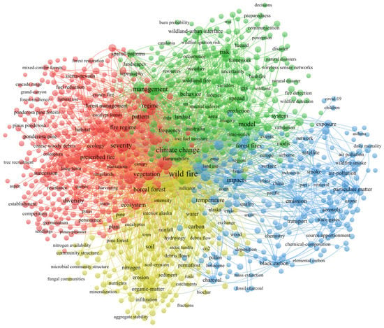
From Figure 1, it can be observed that the overall keywords related to forest fires/wildfires (referred to as “wildfires” collectively) are divided into four clusters. “Wildfires” are the most central and core term, located in the center of the network graph. In the red cluster on the left side, “severity”, “vegetation”, “fire regime”, and “diversity” are some of the typical keywords. In the literature, this cluster mainly represents research in the field of regional ecology, such as studies related to vegetation after wildfires [23,24]. In the yellow cluster below, “soil”, “rainfall”, “erosion”, and “organic-matter” are some representative keywords. The research direction of this cluster primarily focuses on the chemical changes in the environment (especially soil) after wildfires [25,26,27]. It also includes some concurrent disasters, such as rainfall and debris flows [28,29]. The blue cluster on the right side of the map includes representative keywords such as “impact”, “emission”, “smoke”, and “air pollution.” The research related to these keywords is mostly focused on the atmospheric environment field, such as studies on gas emissions and air pollution caused by fires [30,31,32,33].
Figure 1. The co-occurrence graph of keywords.
From
Figure 1, it can be observed that the overall keywords related to forest fires/wildfires (referred to as “wildfires” collectively) are divided into four clusters. “Wildfires” are the most central and core term, located in the center of the network graph. In the red cluster on the left side, “severity”, “vegetation”, “fire regime”, and “diversity” are some of the typical keywords. In the literature, this cluster mainly represents research in the field of regional ecology, such as studies related to vegetation after wildfires [
23,
24]. In the yellow cluster below, “soil”, “rainfall”, “erosion”, and “organic-matter” are some representative keywords. The research direction of this cluster primarily focuses on the chemical changes in the environment (especially soil) after wildfires [
25,
26,
27]. It also includes some concurrent disasters, such as rainfall and debris flows [
28,
29]. The blue cluster on the right side of the map includes representative keywords such as “impact”, “emission”, “smoke”, and “air pollution.” The research related to these keywords is mostly focused on the atmospheric environment field, such as studies on gas emissions and air pollution caused by fires [
30,
31,
32,
33].
The green cluster in the upper-right part of the map includes representative keywords such as “spread”, “risk”, “model”, “behavior”, “climate change”, and “prediction.” The research content associated with these keywords focuses on the study of wildfire spread behavior and risk assessment [
34,
35,
36]. Based on the above content, it is sufficient to demonstrate that the research on wildfire spread behavior and risk assessment is closely related and constitutes important aspects of wildfire research.
Wildfire spread is a highly complex combustion process that occurs as a result of multiple factors acting together [
41]. Although wildfires exhibit certain patterns, they also display nonlinear and complex characteristics [
42]. The driving factors of wildfire spread are generally classified into four categories: meteorological, fuel, topographical, and human factors. These factors collectively influence the behavior of wildfire spread [
43].
3.1. Meteorological Factors
In recent years, many forest ecosystems have undergone changes due to the influence of global climate warming [
44]. As a result, the occurrence of wildfires has been influenced, with climate change contributing to an increase in both the frequency and intensity of wildfires [
45]. Among the meteorological factors, wind speed and wind direction play crucial roles in influencing the spread of wildfires. Wind speed significantly affects the duration of a fire, influencing its spread rate and coverage. Under the combined influence of wind speed and wind direction, the efficiency of heat transfer and the real-time rate of fire spread are directly impacted [
46]. Wind accelerates the spread of wildfires through several pathways: (1) Wind can accelerate the drying of fuel, providing sufficient oxygen and dry fuel within the burning area, which serves as the medium for the occurrence of wildfires and accelerates their spread. (2) Unburned fuel within the forest can be ignited more rapidly under the influence of wind, leading to an accelerated spread of wildfires to surrounding areas. Due to it carrying capacity, wind can transport embers generated during the forest burning process to other unburned areas, resulting in new ignition points at the periphery of the fire, this phenomenon is known as spotting. Spotting makes it easier for the wildfire to rapidly expand its range of spread [
47]. (3) Altering the spatial distribution pattern of fuel can greatly affect the rate of wildfire spread. For example, increasing fuel density or changing the orientation of flammable materials can have a significant impact on the spread rate of wildfires [
48].
3.2. Combustible Factors
Fuel is the material basis for the occurrence and combustion of wildfires [
52]. Macroscopically, fuels can be classified into live fuels and dead fuels based on their vitality [
53]. Here, live fuels refer to vegetation. As of September 2022, according to the resource inventory data released by the National Forestry and Grassland Administration, China’s forest coverage rate has reached 24.02%, with a forest area of 331 million hectares. China’s grassland area is 392.8 million hectares, accounting for 40.90% of the total land area. Due to variations in geographical locations, vegetation exhibits variations in coverage, area, density, structure, and chemical composition. Consequently, different vegetation types have varying ignition points and burning rates to some extent [
54,
55]. Research has shown that the occurrence of wildfires follows certain patterns, adhering to typical time patterns determined by environmental conditions and vegetation phenology cycles. The time span can vary from one day to one year [
56]. Dead fuel primarily refers to litter or dead vegetation material [
57]. Surface litter, with its low density, is the most effective fuel during wildfire combustion. Its impact on fire occurrence is primarily due to the larger gaps between materials, which provide ample oxygen storage as a crucial combustion medium.
3.3. Topography Factors
Basic topographic factors that affect wildfire spread include elevation, slope, and aspect. All three factors are considered static variables [
59]. The impact of topography on wildfire spread rate can be observed in the following aspects: (1) Elevation is an important factor influencing wildfire spread. Different ecological conditions exist at different elevations. Higher elevations are associated with lower temperatures, lower humidity, higher relative humidity, and higher plant moisture content, which reduces the likelihood of ignition. In contrast, lower elevations have lower plant moisture content and are more susceptible to burning [
60,
61]. (2) The impact of slope on wildfires is manifested in its effect on the moisture content of combustible materials. Different slopes have varying durations of rainfall retention, which in turn affects the moisture content of combustible materials. Steeper slopes allow less time for rainfall to stay on the slope, resulting in a quicker drying of combustible materials under the combined influence of temperature and wind after rainfall. This increases the likelihood of fire occurrence. On the other hand, gentle slopes retain a higher percentage of rainfall, which increases the moisture content in combustible materials and reduces the probability and potential for wildfires. Additionally, changes in slope alter the spatial relationship between the burning surface of the wildfire and unburned combustible materials, thereby influencing the spread rate of the wildfire. Generally, uphill and steep slopes exhibit faster spread rates, while downhill and gentle slopes exhibit slower spread rates, although the impact is relatively weaker [
62,
63]. (3) The impact of aspect on the spread rate of wildfires refers to the influence of solar exposure. Sun-facing slopes (southern or western aspects in the Northern Hemisphere) receive stronger solar radiation, resulting in lower humidity and relatively dry microclimatic conditions.
3.4. Human Factors
The majority of wildfires currently occurring are caused by human factors [
65]. Human factors have both positive and negative impacts on wildfires. On one hand, population density directly influences the occurrence of wildfires. Human activities frequently occur in wildland areas, increasing the likelihood of intentional or accidental ignition sources and, consequently, elevating the risk of wildfire spread. High population density in wildland areas increases the likelihood of such ignition sources [
66]. According to data from the National Bureau of Statistics of China, there was a decrease in the number of wildfires from 8859 in 2009 to 2034 in 2016. One of the reasons for this decline is the implementation of the “Forest Fire Prevention Regulations” in 2009, which essentially prohibited outdoor fires [
67].
4. Wildfire Spread Behavior Simulation Application
4.1. Simulation Application Based on Huygens’ Principle
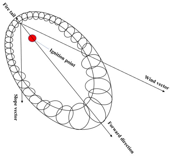
Huygens’ principle [
78] on the process of wildfire spread is illustrated in
Figure 4. Wildfire spread behavior is a complex process involving the interaction of multiple factors. Around the fire scene, each control point is considered as an independent ignition point influenced by external factors such as wind direction, wind speed, and terrain. These factors affect the rate and direction of fire propagation, thereby determining the spread boundary of the fire scene. Typically, the spread boundary of a fire scene presents an elliptical shape, forming an elliptical fire perimeter.
图4.惠更斯原理。
4.1.1. 普罗米修斯
Prometheus于1999年开发,是一个确定性的野火增长模拟应用程序。此应用程序集成了野火科学,计算机技术和数学。基于每日气象数据,它采用计算机模拟来模拟野火蔓延的行为。该软件的开发建立在加拿大荒地火灾增长系统(FBP)[
86]的基础上,该系统是基于典型的经验建模方法开发的模拟软件。普罗米修斯的空间输入数据包括坡度、坡向、燃料类型、天气条件等。基于惠更斯原理,它使用理查兹波传播模型将火周视为独立椭圆火的集合[
71]。
4.1.2. 远方
FARSITE应用程序由美国林务局(US-FS)的米苏拉火灾科学实验室开发。它是一个集热物理、燃烧科学和实验理论于一体的二维矢量模拟系统[
73]。FARSITE可以模拟不同环境条件下各种火灾的蔓延,如地表火灾、冠火和斑点火灾。仿真结果与现场的实际火灾行为非常相似,使其在全球范围内广泛使用[
81]。FARSITE需要GIS(地理信息系统)和RS(遥感)对空间输入数据的支持。使用 FARSITE 进行野火蔓延模拟所需的基本数据包括景观元素数据、天气数据、风场数据和燃料水分数据。国内外已经进行了大量研究,使用FARSITE进行野火蔓延研究。
4.1.3. 火焰地图
FlamMap 是一个景观级应用程序模拟程序,集成了火灾行为建模、燃料管理和地图可视化。它能够模拟潜在的火灾行为特征,例如蔓延速率、火焰长度和火灾强度。此外,它可以模拟火灾的生长和蔓延,以及在天气和燃料湿度等恒定环境条件下的条件燃烧概率。FlamMap结合了火灾分析的各个方面,可以对给定景观中的火灾行为进行全面评估和预测[
93]。FlamMap 中的燃烧概率和火灾大小是使用最小行进时间火灾增长算法 (MTT) 计算的,该算法由 Finney [
94] 开发,并已广泛用于全球空间火灾行为建模研究 [
95,
96]。
4.2. 基于元胞自动机的仿真建模
元胞自动机(CA)是一个可以模拟空间和时间特征的动态系统。在火势蔓延的过程中,假设燃料和地形条件在每个小区内是均匀的,并且火在每个小区内的网格上传播。CA是一种基于网格的动态模型,遵循某些因果关系[
98]。CA 可轻松与来自地理信息系统 (GIS) 或其他来源的数字数据集成,以生成针对特定环境的应用程序。Sullivan和Knight[
99]等人开发了一种具有对流风相互作用的混合二维元自动机模型系统,其扩散应用基于元自动机扩散方法和热对流的半物理模型来模拟野火发生期间的野火扩散边界。Mutthulakshmi的[
100]研究中使用的应用程序基于CA框架,该框架经过改进和优化以模拟野火蔓延,分析影响火灾蔓延的因素并确定哪些因素在野火蔓延中起关键作用。Rui [
101]构建了一个改进的模型系统,该系统将元细胞自动机与现有的野火模型耦合。系统考虑了时间步长对仿真精度的影响,以提供具有高时间和空间一致性的最佳时间步长值。Xu [
102]提出了一种新的火灾蔓延建模方法LSSVM-CA,该方法将最小二乘支持向量机(LSSVM)与三维野火CA框架相结合,并考虑相邻风对火灾蔓延模式的影响进行分析。
5. 野火行为风险评估
5.1. 野火风险评估概述
基于野火预测的野火风险评估方法具有较高的准确性,受天气预报因素的影响较大。它们适用于中等规模范围。另一方面,建立野火风险评估风险指数的方法考虑了多种因素,更适合宏观层面的应用。基于信息扩散理论的方法由于其固有特性,更适合分析小样本。近年来,随着科技能力的快速发展,利用“3S”技术的综合野火风险评估和基于深度学习的野火风险评估得到了广泛的应用。但是,它们需要严格的数据准确性。基于野火行为影响因素的野火风险评估方法和野火蔓延行为模拟的准确性较高。
5.2. 基于野火蔓延行为的野火风险评估
5.2.1.基于影响因素的野火风险评估
从前面的讨论中可以明显看出,野火风险评估旨在综合考虑天气、地形、燃料和人为因素等各种因素。预测和评估野火蔓延过程中的主要驱动因素,为动态火灾管理和预防提供了科学依据。通过对火灾驱动因素的深入研究,可以了解火灾传播的潜在路径、速度和强度。这种认识使资源分配、消防策略、预警系统和紧急疏散措施能够最大限度地减少对个人、财产和环境的潜在危害,保护生态环境和人类安全。
5.2.2.基于行为模拟的野火风险评估
Wildfire risk assessment based on historical fire ignition data combined with fire spread influencing factors or fire spread models is a highly accurate and precise method. By simulating wildfire spread behavior, it is possible to predict the speed, direction, and extent of fire propagation, thus quantitatively assessing the level of wildfire risk. Carmel et al. [
114] created a distribution map of wildfires in Mount Carmel, Israel, covering 20 years of historical fire data. They generated Monte Carlo simulations for fire spread based on these data and used FARSITE software (FlamMap includes FARSITE, currently does not support separate download) to simulate fire spread for 500 fire points. This approach provided a long-term strategic plan for fire prevention activities in the area.
This entry is adapted from the peer-reviewed paper 10.3390/fire6060228