Your browser does not fully support modern features. Please upgrade for a smoother experience.
Submitted Successfully!
 +1 credit
Thank you for your contribution! You can also upload a video entry or images related to this topic.
For video creation, please contact our Academic Video Service.
| Version | Summary | Created by | Modification | Content Size | Created at | Operation |
|---|---|---|---|---|---|---|
| 1 | Argyro Argyrou | -- | 1928 | 2022-11-29 19:57:11 | | | |
| 2 | Catherine Yang | -7 word(s) | 1921 | 2022-11-30 02:50:55 | | |
Video Upload Options
We provide professional Academic Video Service to translate complex research into visually appealing presentations. Would you like to try it?
Cite
If you have any further questions, please contact Encyclopedia Editorial Office.
Argyrou, A.; Agapiou, A. Artificial Intelligence in Archaeology. Encyclopedia. Available online: https://encyclopedia.pub/entry/37173 (accessed on 14 July 2026).
Argyrou A, Agapiou A. Artificial Intelligence in Archaeology. Encyclopedia. Available at: https://encyclopedia.pub/entry/37173. Accessed July 14, 2026.
Argyrou, Argyro, Athos Agapiou. "Artificial Intelligence in Archaeology" Encyclopedia, https://encyclopedia.pub/entry/37173 (accessed July 14, 2026).
Argyrou, A., & Agapiou, A. (2022, November 29). Artificial Intelligence in Archaeology. In Encyclopedia. https://encyclopedia.pub/entry/37173
Argyrou, Argyro and Athos Agapiou. "Artificial Intelligence in Archaeology." Encyclopedia. Web. 29 November, 2022.
Copy Citation
Artificial Intelligence (AI), due to its increasingly powerful predictive capabilities, is showing an increasing trend in attracting widespread interest in many sciences. Archaeologists now can more fully exploit the knowledge from an extensive amount of archaeological data with the use of artificial intelligence in such a way as to make decisions related to appropriate strategies for the preservation and protection of archaeological elements, as well as to decide on the most ideal point excavation in a complex cultural landscape.
artificial intelligence
remote sensing
archaeology
surface detection
1. Key Components of AI
Jamil et al. [1], in recent research (in the beginning of 2022), refer to, that, in the archaeology field, most of the ML and DL algorithms are used for classification and identification of artifacts. But, in contrast, detection of archaeological data using DL is still insufficient. The main elements of the AI that is used in archaeology can be seen in Figure 1 below.
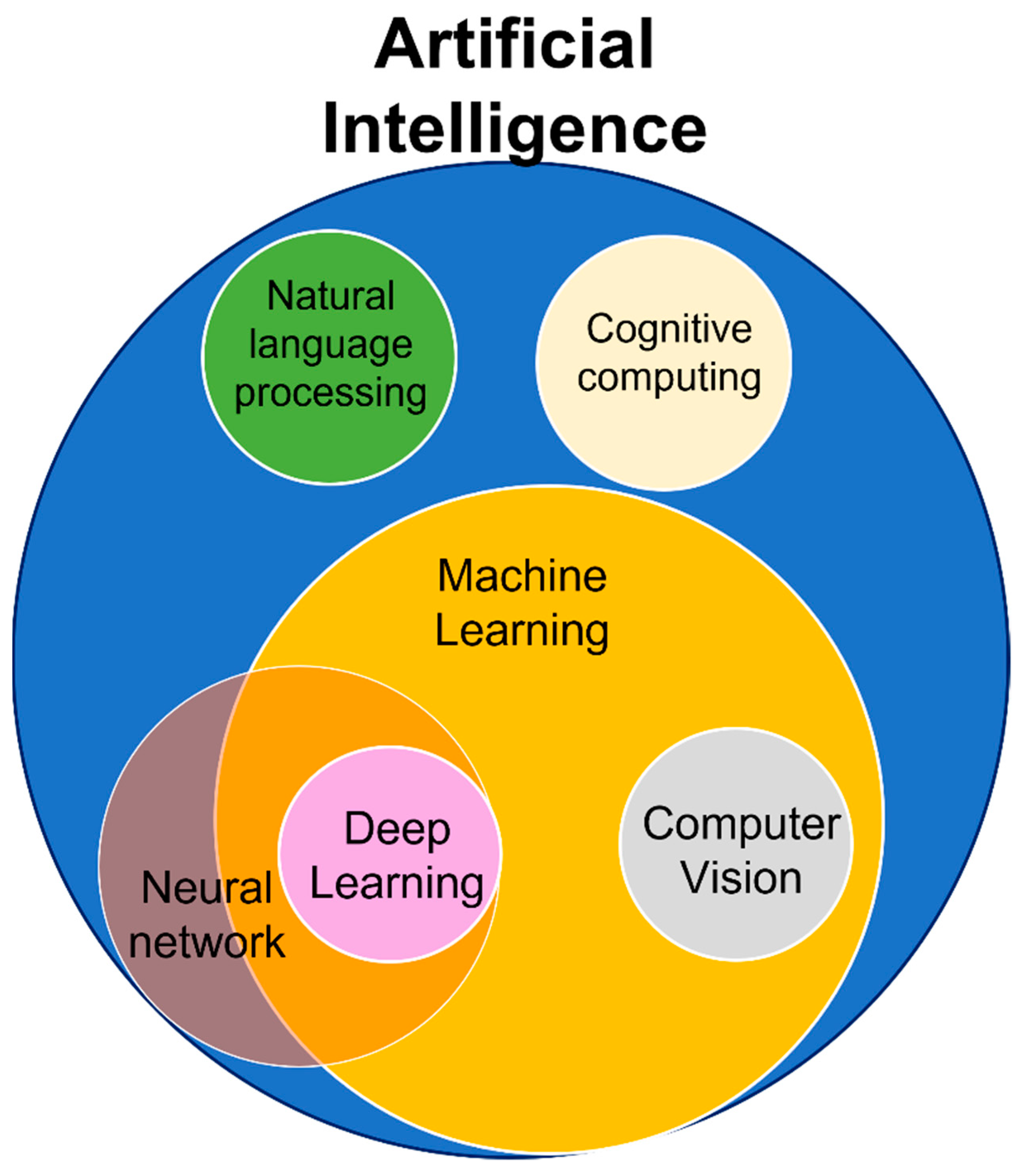
Figure 1. Key Components of AI.
-
Machine learning: allows software applications to become more accurate at predicting outcomes without the requirement for explicit programming.
-
Deep learning: a subset of ML that learns by processing data based on artificial neural networks with representation learning.
-
Neural network: NN mimics the way the human brain operates with a series of algorithms that endeavors to recognize underlying relationships in a set of data.
-
Natural language processing (NLP) is a subfield of computer science and artificial intelligence concerned with the recognition, interpretation, and production of human language and speech.
-
Computer vision: a subset of machine learning and pattern identification that enables computers to interpret image content based on graphs, tables, PDF pictures, and videos.
-
Cognitive computing: this is related to technology platforms that attempt to mimic the way a human brain works.
2. Applications of AI and Remote Sensing for Archaeological Research
Applications of AI and remote sensing for archaeological research is still in its beginning, as this is illustrated in the literature research that was applied.
In this entry of AI and RS for archaeological research, two focus areas were predetermined, which are RS for archaeological research, and AI for archaeological research. This second search was also conducted using the Scopus engine database and the Dimensions engine during the same period that the remote sensing search took place, as referred above. The search was based on TITLE-ABS-KEY (artificial AND intelligence AND “archaeol*” OR “archeol*”) AND PUBYEAR > 1999. The results were again only from 2000 and onwards. Regarding the search on Dimensions, the keyword “artificial intelligence AND “archaeol*” OR “archeol*” was used, and the results were again limited to articles from 2000 to the present, and the search category was set to “Archaeology” and “History, Heritage and Archaeology”.
Results show a general trend of fluctuating publications (Figure 2), while the number of papers between the two searches related to artificial intelligence in archeology differs. More specifically, in the Scopus survey of 2020, there appears a peak of publications in contrast to the Dimensions survey, where the publications are quite high, but not as significant as in 2018 or the current year (2022).
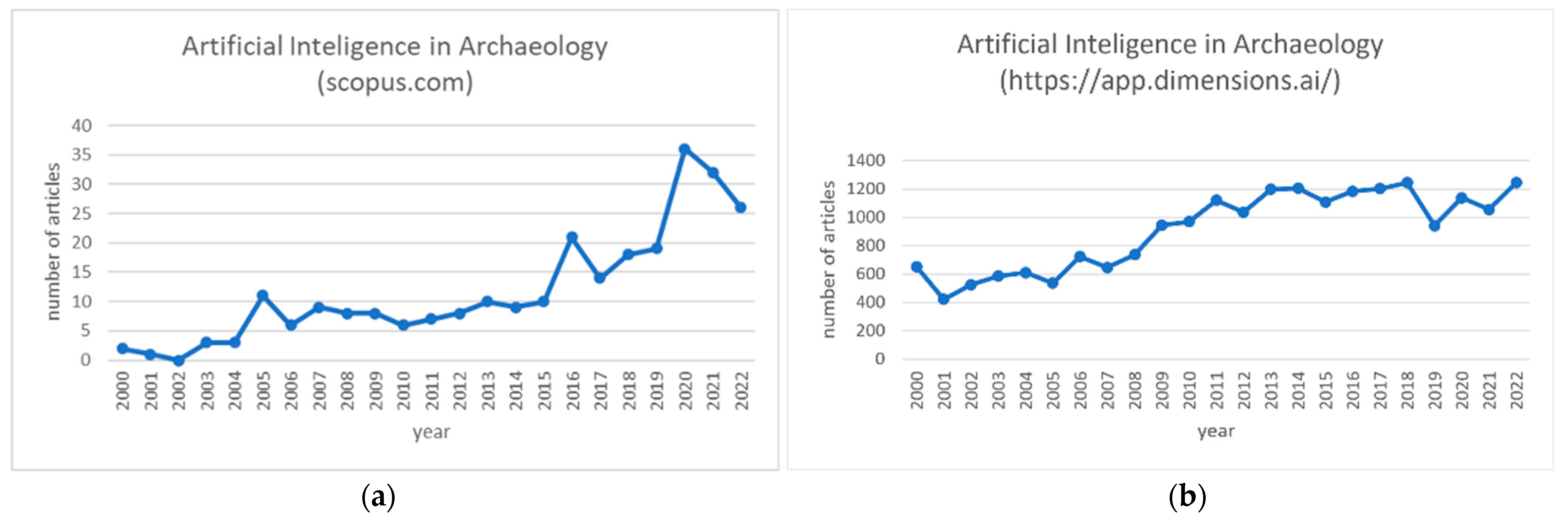
Figure 2. Annual publications of artificial intelligence in archaeology since 2000 (a) source: Scopus.com, (accessed on 15 October 2022), (b) source: https://www.dimensions.ai (accessed on 10 November 2022).
This can be the result of an ongoing debate about the appropriateness of AI methods in archaeological practice, but it can also be another effect of the COVID-19 pandemic. Another reason can be the disagreement of researchers about the definitions that researchers emphasize. Thus, a complex phenomenon might turn into simple phrases that end up being even more complex than the phenomena they intend to define [2]. One question is whether we ultimately need AI and to what extent. Is an AI ultimately smarter than it really is, or is it smarter that is believed to be? Do these models make errors and, if so, what kinds of errors? Are these errors similar or different from humans’ errors? All these questions lead to the concept of the so-called barrier of meaning [3]. With this term, the researchers want to highlight the gap that exists between the knowledge of the expert and the knowledge captured by the machine. In other words, this represents the gap between the actual process we are trying to automate with an AI and its final approximation. Therefore, in the process of designing an AI-based system, the researchers must not forget the existence of this gap. Nevertheless, as shown by various recent archaeological studies, when the researchers have a very well-designed model, the results can provide consistency, high accuracy, and an estimate of probability in the identification of archaeological remains without any automated detection replacing human experts [4].
Sharafi et al., in their 2016 paper [5], provided clear evidence that pattern recognition has real potential as an effective application of artificial intelligence to locate archaeological burials. In addition, it is believed that the expensive and time-consuming efforts of surveying and excavating landscape areas that present a limited extent of archaeological content can be avoided by archaeologists. In the field of archaeology, as reported by Jamil et al. [6], there has been a growing trend in recent years to use artificial intelligence algorithms, such as ML and DL, for artifact classification and recognition. However, in the same paper, it is mentioned that the research on the detection of archaeological structures, especially those applying the DL algorithm or using aerial imaging, is still insufficient.
Below are presented five examples of publications from recent years, and especially 2020, from research applications of AI to locate archaeological remains using drone and satellite images.
Orengo and Garcia-Molsosa, back in 2019 [7], published an article related to automated ML-based potsherd detection using high-resolution drone imagery. The results of this paper show that the potential of this technique, if applied under appropriate field circumstances, can produce accurate distribution maps of individual potsherds providing new potentials of archaeological survey. The workflow combined drone photogrammetry and ML to automatically record surface distributions of archaeological material. As a result, it provided faster results and higher analytical capabilities under favorable conditions compared to a traditional pedestrian survey.
In 2020, Mehrnoush et al. [8] published an article for research applying CNN based deep learning model to detect a qanat shaft using Cold War-era CORONA satellite images. This was a first attempt of utilizing automated detection on historical satellite images for automated qanat shaft detection. Data collection, data pre-processing, model construction, and model assessment were included in the ML pipeline. For model training, images with both low and high density of qanat features were included. The results obtained showed an overall precision and recall for the model of 0.62 and 0.74, respectively.
In the same year (2020), Bundzel et al. [9] applied a semantic segmentation of airborne LiDAR data to Maya archaeology. Two deep learning-based models for semantic segmentation, U-Net and Mask R-CNN, were built and compared with each other. These two segmentation models were used in two tasks: first, to identify areas of ancient construction activity and, second, to identify the remains of ancient Maya buildings. The research results showed that the model based on U-Net performed better on both tasks and had a recognition rate for all items between 60 and 66%.
Another example of AI was presented in 2020 by Orengo et al. [10], which was related to an automated detection approach for archaeological mounds. That work presented an innovative multi-sensor, multi-temporal machine learning approach using large RS data to detect archaeological mounds in Cholistan (Pakistan). In this research, the Google Earth Engine was used, in which a classifier algorithm was implemented that used multispectral images and a collection of large-scale synthetic aperture radars. The result covered a range of approx. 36,000 km2, in which many more archaeological mounds emerged than previously recorded, giving other possibilities for understanding the area from an archaeological point of view. The signature classification process involved (a) collecting training data, (b) training the classifier model, (c) classifying the image composition, and, finally, (d) validating the classifier with an independent validation set. All previously known mounds in the study area were detected using a ML algorithm, and, in addition, accurate locations and many new mounds were gathered, far exceeding the expectations set by previous research.
Recently, in 2021, Berganzo-Besga et al. [11] introduced, for the first time, an improved AI algorithm for large-scale automatic detection of archaeological tombs, which are a common type of archaeological structure, using LiDAR and multispectral satellite data. The results of the survey are a valid alternative to the manual detection of this type of archaeological remain. This research combined machine learning techniques (random forest) for terrain classification using multi-temporal multispectral Sentinel-2 data, as well as a DL model on LiDAR data, previously pre-processed using a multi-scale terrain model. The algorithm used was an improved version of a previous attempt, with a detection rate of 89.5%, an average accuracy of 66.75%, and a precision of 0.97. As a result, 10,527 burial tumuli over an area of about 30,000 km2 were identified. This approach is the largest that has been applied so far from a small training data set. This method can be used wherever LiDAR data or high-resolution digital terrain models are available, since the code and platforms used to develop the algorithm are open source.
A recent study, combining DL and traditional ML, was published by Davis et al. in 2021 [12]. What researchers showed was that both deep learning and automation can be used to detect new archaeological features, but also to systematically estimate the spatial extents of certain archaeological buildings. Specifically, this study used a multidimensional procedural workflow to detect shell rings. Using multiple data sources, such as LiDAR, SAR, multispectral, and new analytical methods, researchers have identified over 100 extant shell rings throughout South Carolina. A further quantification of the geographical extent of this building tradition showed that many of these features are quite small compared to known examples, suggesting that not all shell rings were used as monumental centers. The DL model, as well as all the code used for the above analysis, is open source, with the main goal for future researchers being that of using it and improve the results.
Further important findings, together with those published by Agapiou et al. [13], following the work of [7], show that low-altitude remote sensing sensors (e.g., UAVs) can provide significant outcomes. Following these cases, a simulation study was recently (May 2022) implemented by authors in Cyprus, aiming to adopt low-altitude multispectral and RGB cameras to investigate whether a semi-automated methodology for recording potsherds could be developed to answer research questions for a more efficient approach in terms of time and accuracy compared to traditional fieldwalking archaeological surveys.
ML algorithms, such as random forest (RF) classifiers, have been implemented and compared along with the results from foot surveys. Utilizing workflow of [7] in the study, the overall accuracy and relative accuracy were estimated (average accuracy around 90%). The preliminary results (Figure 3) were compared with the archaeological surface survey records, showing that semi-automatic detection methods using low-altitude remote sensing sensors can be used as a first proxy indicator for the detection of surface archaeological ceramics.

Figure 3. Preliminary results of surface archaeological ceramics using semi-automatic detection methods and low-altitude remote sensing sensors (Red dots indicate positive detections classified as ceramics after the implementation of RF classifier).
These results and accuracy were very promising but can vary, depending on a variety of factors, such as the type of soil, the conditions of the plot, the period of flight, the visibility, the type of crops, and the quantity of the material culture, but also the number and experience of the inspectors. Certainly, in the future, further improvements can be made and more sophisticated remote sensing algorithms will be used to cover even larger areas with a higher success rate.
References
- Jamil, A.H.; Yakub, F.; Azizul Azizan, A.; Roslan, S.A.; Zaki, S.A.; Ahmad, S.A. A Review on Deep Learning Application for Detection of Archaeological Structures. J. Adv. Res. Appl. Sci. Eng. Technol. 2022, 26, 7–14.
- Davis, D.S. Defining what we study: The contribution of machine automation in archaeological research. Digit. Appl. Archaeol. Cult. Herit. 2020, 18, e00152.
- Mitchell, M. Complexity. A Guided Tour; Oxford Press: Oxford, UK; New York, NY, USA, 2009; pp. 186–208.
- Casini, L.; Roccetti, M.; Delnevo, G.; Marchetti, N.; Orrù, V. The Barrier of meaning in archaeological data science. In Proceedings of the SCIFI-IT’ 2020—4th Annual Science Fiction Prototyping Conference, Ghent, Belgium, 23–25 March 2020; pp. 61–65.
- Sharafi, S.; Fouladvand, S.; Simpson, I.; Alvarez, J.A.B. Application of pattern recognition in detection of buried archaeological sites based on analysing environmental variables, Khorramabad Plain, West Iran. J. Archaeol. Sci. Rep. 2016, 8, 206–215.
- Domínguez Rodrigo, M.; Cifuentes Alcobendas, G.; Jiménez García, B.; Abellán, N.; Pizarro Monzo, M.; Organista, E.; Baquedano, E. Artificial intelligence provides greater accuracy in the classification of modern and ancient bone surface modifications. Sci. Rep. 2020, 10, 18862.
- Orengo, H.A.; Garcia-Molsosa, A. A brave new world for archaeological survey: Automated machine learning-based potsherd detection using high-resolution drone imagery. J. Archaeol. Sci. 2019, 112, 105013.
- Mehrnoush, S.; Mehrtash, A.; Khazraee, E.; Ur, J. Deep Learning in Archaeological Remote Sensing: Automated Qanat Detection in the Kurdistan Region of Iraq. Remote Sens. 2020, 12, 500.
- Bundzel, M.; Jašcur, M.; Kovác, M.; Lieskovský, T.; Sincák, P.; Tkácik, T. Semantic Segmentation of Airborne LiDAR Data in Maya Archaeology. Remote Sens. 2020, 12, 3685.
- Orengo, H.A.; Conesa, F.C.; Garcia-Molsosa, A.; Lobo, A.; Green, A.S.; Madella, M.; Petrie, C.A. Automated detection of archaeological mounds using machine learning classification of multi-sensor and multi-temporal satellite data. Proc. Natl. Acad. Sci. USA 2020, 117, 18240–18250.
- Berganzo-Besga, I.; Orengo, H.A.; Lumbreras, F.; Carrero-Pazos, M.; Fonte, J.; Vilas-Estévez, B. Hybrid MSRM-Based Deep Learning and MultitemporalSentinel 2-Based Machine Learning Algorithm Detects Near 10k Archaeological Tumuli in North-Western Iberia. Remote Sens. 2021, 13, 4181.
- Davis, D.S.; Gaspari, G.; Lipo, C.P.; Sanger, M.C. Deep learning reveals extent of Archaic Native American shell-ring building.practices. J. Archaeoogical Sci. 2021, 132, 105433.
- Agapiou, A.; Vionis, A.; Papantoniou, G. Detection of Archaeological Surface Ceramics Using Deep Learning Image-Based Methods and very High-Resolution UAV Imageries. Land 2021, 10, 1365.
More
Information
Subjects:
Archaeology; Remote Sensing
Contributors
MDPI registered users' name will be linked to their SciProfiles pages. To register with us, please refer to https://encyclopedia.pub/register
:
View Times:
6.7K
Entry Collection:
Remote Sensing Data Fusion
Revisions:
2 times
(View History)
Update Date:
30 Nov 2022
Table of Contents


Notice
You are not a member of the advisory board for this topic. If you want to update advisory board member profile, please contact office@encyclopedia.pub.
OK
Confirm
Only members of the Encyclopedia advisory board for this topic are allowed to note entries. Would you like to become an advisory board member of the Encyclopedia?
Yes
No
${ textCharacter }/${ maxCharacter }
Submit
Cancel
Back
Comments
${ item }
|
${ item.createdUser.fullName }
${ item.createdAt }
${ item.vote }
${ item.reply }
Delete
${ reply.createdUser.fullName }
${ reply.createdAt }
${ reply.vote }
Delete
There is no reply to this comment~
${ item.replyTextCharacter }/${ item.replyMaxCharacter }
Submit
Cancel
More
No more~
There is no comment~
${ textCharacter }/${ maxCharacter }
Submit
Cancel
${ selectedItem.replyTextCharacter }/${ selectedItem.replyMaxCharacter }
Submit
Cancel
Confirm
Are you sure to Delete?
Yes
No