Your browser does not fully support modern features. Please upgrade for a smoother experience.
Submitted Successfully!
 +1 credit
Thank you for your contribution! You can also upload a video entry or images related to this topic.
For video creation, please contact our Academic Video Service.
Video Upload Options
We provide professional Academic Video Service to translate complex research into visually appealing presentations. Would you like to try it?
Cite
If you have any further questions, please contact Encyclopedia Editorial Office.
Wang, H.; , . Weihe River Basin (WRB) Introduction and Governance Process. Encyclopedia. Available online: https://encyclopedia.pub/entry/22663 (accessed on 24 June 2026).
Wang H, . Weihe River Basin (WRB) Introduction and Governance Process. Encyclopedia. Available at: https://encyclopedia.pub/entry/22663. Accessed June 24, 2026.
Wang, Heng, . "Weihe River Basin (WRB) Introduction and Governance Process" Encyclopedia, https://encyclopedia.pub/entry/22663 (accessed June 24, 2026).
Wang, H., & , . (2022, May 06). Weihe River Basin (WRB) Introduction and Governance Process. In Encyclopedia. https://encyclopedia.pub/entry/22663
Wang, Heng and . "Weihe River Basin (WRB) Introduction and Governance Process." Encyclopedia. Web. 06 May, 2022.
Copy Citation
A river basin is a complete “nature–society–economy” complex system composed of natural factors such as water resources, land, and plants and human factors such as population, society, and economy. The social-ecological system (SES) framework has been put forward, which provides a new direction for the solution of complex problems in river basins. Through the use of common human language, the SES framework enables researchers to more deeply analyze the interaction between variables in the complex social ecosystem so as to form a systematic knowledge accumulation of research results in different fields.
diagnose
social-ecological systems
watershed environmental governance
Weihe River Basin
1. Introduction
With climate change and rapid population growth, governments should consider the interaction between river basins and socio-economic development. A river basin is a complete “nature–society–economy” complex system composed of natural factors such as water resources, land, and plants and human factors such as population, society, and economy [1]. The water resource is an important basic link between different units of this complex system [2]. However, with rapid economic development and population growth, the economic functions of river basins have been overexploited by human beings, while the protection of ecological functions has been neglected. This resulted in a series of eco-environmental problems, including water pollution, water ecological damage, water shortages, and frequent floods. The water eco-environmental crisis has become an important challenge to the sustainable development of human beings [3]. Therefore, river basin eco-environmental management has become an important task of ecological environment governance and should be improved to realize the coordinated and sustainable development of the economy, society, and ecological environment in the entire basin.
At present, the actual management process of river basins in China is mainly to divide the entire river according to administrative regions, which are managed by each administrative region through administrative means [4]. However, the river basin is a complex social-ecological system that involves water resources, ecological environments, and socio-economic factors. Hence, it is difficult for a single department or a single element of administrative management to solve complicated problems associated with it. Further, natural dimensions and social dimensions interweave and influence each other, making it difficult to adapt to the protection of ecological function and sustainable development of the social economy. Thus, it is urgent that researchers innovate and solve related problems to determine the basic function, management goal order, and feasible path of the basin from the perspective of the entire nature and society. The social-ecological system (SES) framework has been put forward [5], which provides a new direction for the solution of complex problems in river basins. Through the use of common human language, the SES framework enables researchers to more deeply analyze the interaction between variables in the complex social ecosystem so as to form a systematic knowledge accumulation of research results in different fields. The SES framework has been applied in the management of the Ganges [6].
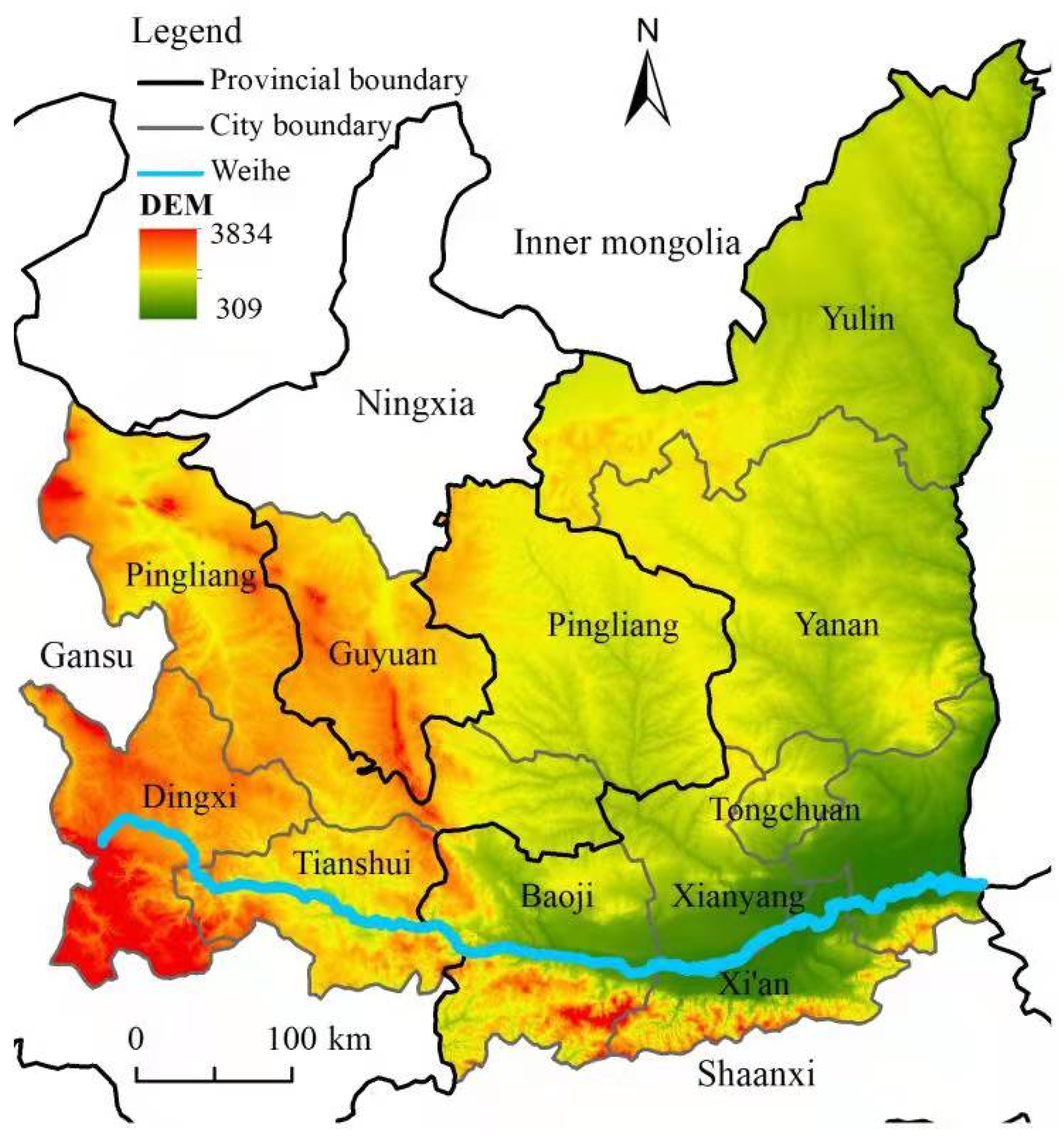 Figure 1. Schematic diagram of Weihe River Basin Governance process concerning the WRB.
2. Literature and Theoretical Analysis
The basin is a special multi-dimensional natural region linked by rivers, which has strong integrity and relevance. The global water resources management cooperation organization defines watershed governance as management to promote the coordinated development of water, land, and other related resources and to maximize economic and social welfare within the affordability of the ecosystem. The ecology regards the watershed as a complete natural unit and considers that the main content of watershed management is to plan the agriculture, forestry, animal husbandry, and fishery scientifically and to exploit natural resources such as water and land reasonably [7]. From the perspective of public management, watershed management is mainly carried out in the form of multi-agent cooperation with the participation of government, society, and the public, that is, a multi-center management process and action network with the interaction of government, society, and the market [8]. This multi-center management model will inform the development direction of watershed management in the future.
When natural science studies ecological environmental problems, it usually takes the natural ecosystem as its main research object and treats humans simply as external, neglecting the relationship between human and ecological environmental communities [9][10]. However, when social science studies ecological environmental problems, it emphasizes the importance of human social interaction, and it is relatively easy to ignore the natural background of this human interaction [11]. In fact, the watershed system is a composite system dominated by humans, resources, and ecology, including social subsystems, economic subsystems, and natural subsystems, that is, a watershed social-economic-natural composite system [12]. When any discipline studies the watershed ecological environment, it is inadequate to focus only on the specific problems within that research field. The reasons behind the watershed ecological problems are complex and diverse. The relationship between human society and the water environment is not a simple linear relationship; rather, there are complex effects, such as nonlinearity, circular feedback, heterogeneity, and mutation [13]. Based on these explorations of the relationship between human society and eco-environmental systems, also known as a human-environmental system (HES), SES has gradually developed and formed. SES regards the human social system and the ecological environment system as a multi-dimensional interactive coupled whole, the constituent parts of which are closely related and interdependent; all the natural resources used by human beings are embedded in them, whether in the form of organization or in time and space [5].
From the perspective of SES coupling, the deterioration of water ecological environments is caused by the disharmony among the population, economy, politics, science, and technology. As a part of the broader SES interaction chain, to formulate an institution suited to the local situation and to achieve success in watershed ecological environment governance, it is necessary to clarify the complex relationship between human social systems and the natural ecosystem in the organizational category, as well as in space and time [14]. This requires a common analysis framework that can not only integrate a variety of knowledge concepts in social, economic, ecological, and geographical disciplines but also accommodate multi-scale, nonlinear key variables across time and space in the social ecosystem [15]. To this end, Elinor Ostrom developed a new diagnostic method (multi-level nested framework), namely, the SES diagnostic framework, based on the common-pool resources governance theory and the institutional analysis and development framework [16]. The SES framework can integrate interdisciplinary related knowledge and provide a path for different disciplines to identify, diagnose, and analyze the sustainable development of social ecosystems. Under the regulation of the governance system, actors carry out a series of interactions around the use and maintenance of the resource system and produce corresponding results, thus forming a feedback effect on the resource system. This process closely connects human social systems and natural resource systems, constituting the action situation of ecological environment governance, and can be considered the core of the SES diagnostic analysis framework. As nodes nested in social-ecological systems, resource systems and governance systems are also affected by a wider range of social, economic, political, and ecological environmental background variables. Therefore, the SES diagnostic analysis framework is composed of eight construction units.
Ostrom summarized previous research results and further subdivided the eight primary variable groups of the SES framework into several secondary variables [17]. Researchers can also continue to subdivide these secondary variable groups according to specific research needs. The application of the SES framework to diagnose the complex watershed ecological environment and identify the key factors and variables affecting the sustainable development of the watershed ecological environment is a new methodology for the research of watershed ecological environment governance.
Rivers have transboundary characteristics, and the implementation of the entire watershed management plan depends on whether the watershed boundary can be clearly divided [18]. The continuous growth of the global population makes the scarcity of water resources more and more prominent [19]. The dynamic prediction of the water resources system is an important link to preventing ecological risks and water quality risks in the river basin [20]. Therefore, for the resource system, clarity of system boundaries, scarcity of water resources, and predictability of system dynamics are the key variables affecting river basin governance. Because of the mobility of water resources, the pollution of rivers presents randomness, fuzziness, and wide distribution, making it difficult to determine the restoration range of river basins [21]. Therefore, for the resource unit system, resource unit mobility is the key variable affecting river basin governance. Concerning the governance system, nongovernmental organizations (NGOs), operational-choice rules, and degree of local autonomy are the key variables affecting river and lake watershed governance. By establishing extensive cooperation with governmental organizations in river basin ecological environment governance, nongovernmental organizations directly or indirectly assist the local government in the form of research, training, publicity, and education [22]. Under the bureaucratic basin management system, the local government’s basin management operating rules and the local degree of autonomy are important factors affecting the success of river basin governance measures [23]. With regard to actors, the number of relevant actors, leadership, social capital, and social-ecological cognition are the key variables affecting watershed governance. The higher the number of watershed-governance-related actors, the higher the potential scale benefit of watershed governance will be, but correspondingly, transaction costs will also increase [24]. The ecological awareness, social capital, and leadership of river basin governance participants will affect their sense of responsibility and initiative and ultimately determine the effect of public participation in river basin governance [25]. In the analysis of specific cases, the identification of key variables may be far more than these, and researchers need to make their own judgment.
3. Weihe River Basin (WRB) Introduction and Governance Process
3.1. Data Collection
The basic overview information of WRB comes from the materials provided by the Shaanxi Provincial Department of Water Resources and the Department of Natural Resources. The hydrological information of the WRB comes from the statistical data set of natural conditions of WRB (1999–2017), the environmental status bulletin of Shaanxi province (2018), and the Annual Hydrological Data of the Yellow River Basin (2001–2016).
3.2. Overview of the WRB
The WRB, an important part of the Loess Plateau, is the largest tributary of the Yellow River. It originates in Gansu province, flows through Shaanxi province, and flows into the Yellow River at Tongguan County of Shaanxi Province. The WRB covers an area of 135,000 km2, and the total length of the main stream is 818 km, among which Shaanxi province covers an area of 67,600 km2, and the length is 512 km (Figure 1). The annual average runoff in the Shaanxi section of the Weihe River is 4.424 billion m3, the annual average flow is 140 m3/s, and the annual average sediment discharge is 118.5 million tons [26]. The farmland irrigation area of the Weihe River is nearly 93,300 hm2, and 65% of Shaanxi’s GDP is concentrated in the WRB. Weihe River is the only sewage and wastewater receiving and discharging channel in the Guanzhong area of Shaanxi Province, receiving 78% of industrial wastewater and 86% of domestic sewage in the province.
Figure 1. Schematic diagram of Weihe River Basin Governance process concerning the WRB.Since 1949, the Chinese government has not stopped harnessing the WRB, having built a large number of embankment projects and a complete flood control system and having ensured the normal agricultural production of nearly 598,000 people on both sides of the river. In 2004, Xianyang city started the “Xianyang Lake” construction project. The Xianyang section of the Weihe River has built a water surface landscape of 720 hm2 with a length of 13.4 km, a width of 500–700 m. In 2015, the Xi’an railway bureau built a new concrete face rockfill dam in the main channel of the Weihe River one km downstream of the railway bridge, effectively controlling the threat of the riverbed undercutting railway safety. In 2017, the 105 km flood control dike in Xianyang city was built, which significantly improved the flood control capacity of the WRB and became a new highlight of economic and social development along the river.
At the end of the last century, due to the general pollution of trunks and tributaries, the water quality of the Weihe River was poor. In 2000, class III water quality accounted for 37.2%, class IV water quality accounted for 12.2%, and class V water quality accounted for 50.6% in the main stream of the Weihe River. The water quality of the river section under the jurisdiction of Xianyang city is in class V all year round, which has lost the basic function of a water body, and its fish are extinct. In 2016, the water quality of the Xianyang city section of the Weihe River was at a class IV water standard. In recent years, the water conservancy department has carried out artificial proliferation and stocking activities in the Weihe River, successively built 337 hm2 of aquaculture water surface dominated by intensive ponds, and its production capacity has reached 4644 tons, which has restored the fishery resources of the Weihe River to a certain extent
After years of treatment, especially the construction of a comprehensive restoration project, the basin environment of the Xianyang city section of the Weihe River has undergone fundamental changes compared with before. However, the ecological environment management of the WRB still poses many problems. The first is the lack of ecological river flow. According to the regulations, the ecological flow of the Weihe River is 15 m3/s, and the good ecological flow is 20 m3/s. According to the statistical data from 2004 to 2011, the ecological flow was still less than 15 m3/s in some periods from December of that year to March of the next year, and the maximum occurrence days reached 76 days. The period for which there is less than 20 m3/s of good ecological flow is mainly concentrated from June to August each year, and its maximum duration is 43 days. The second is the serious problem of main channel undercutting. In 2013, compared with 1999, the average channel thalweg point was cut down by 6.78 m, and the maximum cutting depth reached 8.69 m. The average undercut of the main channel in the Xianyang section of the Weihe River is about 7 m. The third is the difficulty of river management. In 2014, Shaanxi provincial department of water resources requested that the mining of the entire Weihe River be banned, resulting in a rapid rise in sand prices; some sand mining enterprises were driven by explosive profits to illegally mine.
References
- Marshall, A.; Duram, L.A. Factors influencing local stakeholders’ perceptions of Tisza River Basin management: The role of employment sector and education. Environ. Sci. Policy 2017, 77, 69–76.
- Fidélis, T.; Roebeling, P. Water resources and land use planning systems in Portugal—Exploring better synergies through Ria de Aveiro. Land Use Policy 2014, 39, 84–95.
- Yuan, F.; Wei, Y.D.; Gao, J.; Chen, W. Water crisis, environmental regulations and location dynamics of pollution-intensive industries in China: A study of the Taihu Lake watershed. J. Clean. Prod. 2019, 216, 311–322.
- Zhou, R.; Li, Y.; Wu, J.; Gao, M.; Wu, X.; Bi, X. Need to link river management with estuarine wetland conservation: A case study in the Yellow River Delta, China. Ocean. Coast. Manag. 2017, 146, 43–49.
- Ostrom, E. A General Framework for Analyzing Sustainability of Social-Ecological Systems. Science 2009, 325, 419–422.
- Gain, A.K.; Rahman, A.U.; Vafeidis, A.T. Exploring human-nature interaction on the coastal floodplain in the Ganges-Brahmaputra delta through the lens of Ostrom’s social-ecological systems framework. Environ. Res. Commun. 2019, 1, 051003.
- Simms, R.; Harris, L.; Joe, N.; Bakker, K. Navigating the tensions in collaborative watershed governance: Water governance and Indigenous communities in British Columbia, Canada. Geoforum 2016, 73, 6–16.
- Barnhart, B.L.; Golden, H.E.; Kasprzyk, J.R.; Pauer, J.J.; Jones, C.E.; Sawicz, K.A.; Hoghooghi, N.; Simon, M.; McKane, R.B.; Mayer, P.M.; et al. Embedding co-production and addressing uncertainty in watershed modeling decision-support tools: Successes and challenges. Environ. Model. Softw. 2018, 109, 368–379.
- Auad, G.; Blythe, J.; Coffman, K.; Fath, B.D. A dynamic management framework for socio-ecological system stewardship: A case study for the United States Bureau of Ocean Energy Management. J. Environ. Manag. 2018, 225, 32–45.
- Liu, J.; Dietz, T.; Carpenter, S.R.; Alberti, M.; Folke, C.; Moran, E.; Pell, A.N.; Deadman, P.; Kratz, T.; Lubchenco, J.; et al. Complexity of Coupled Human and Natural Systems. Science 2007, 317, 1513–1516.
- Pritchett, L.; Woolcock, M. Solutions When the Solution is the Problem: Arraying the Disarray in Development. World Dev. 2004, 32, 191–212.
- Deng, X.; Zhao, Y.; Wu, F.; Lin, Y.; Lu, Q.; Dai, J. Analysis of the trade-off between economic growth and the reduction of nitrogen and phosphorus emissions in the Poyang Lake Watershed, China. Ecol. Model. 2011, 222, 330–336.
- Walker, B.; Holling, C.S.; Carpenter, S.R.; Kinzig, A. Resilience, adaptability and transformability in social–ecological systems. Ecol. Soc. 2004, 9, 5–12.
- Ostrom, E. Beyond Markets and States: Polycentric Governance of Complex Economic Systems. Am. Econ. Rev. 2010, 100, 641–672.
- Ostrom, E. A diagnostic approach for going beyond panaceas. Proc. Natl. Acad. Sci. USA 2007, 104, 15181–15187.
- McGinnis, M.D.; Ostrom, E. Social-ecological system framework: Initial changes and continuing challenges. Ecol. Soc. 2014, 19, 30.
- Ostrom, E.; Walker, J.; Gardner, R. Covenants with and without a Sword: Self-Governance Is Possible. Am. Political Sci. Rev. 1992, 86, 404–417.
- Tishchenko, P.Y.; Tishchenko, P.P.; Lobanov, V.B.; Mikhaylik, T.A.; Sergeev, A.F.; Semkin, P.Y.; Shvetsova, M.G. Impact of the transboundary Razdolnaya and Tumannaya Rivers on deoxygenation of the Peter the Great Bay (Sea of Japan). Estuar. Coast. Shelf Sci. 2020, 239, 106731.
- Walter, M.T.; Walter, M.F.; Brooks, E.S.; Steenhuis, T.S.; Boll, J.; Weiler, K. Hydrologically sensitive areas: Variable source area hydrology implications for water quality risk assessment. J. Soil Water Conserv. 2000, 55, 277–284.
- King, R.S.; Richardson, C.J. Integrating Bioassessment and Ecological Risk Assessment: An Approach to Developing Numerical Water-Quality Criteria. Environ. Manag. 2003, 31, 795–809.
- Dowd, B.M.; Press, D.; Los Huertos, M. Agricultural nonpoint source water pollution policy: The case of California’s Central Coast. Agric. Ecosyst. Environ. 2008, 128, 151–161.
- Ayana, A.N.; Arts, B.; Wiersum, K.F. How environmental NGOs have influenced decision making in a ‘semi-authoritarian’ state: The case of forest policy in Ethiopia. World Dev. 2018, 109, 313–322.
- Moore, S. Toward effective river basin management (RBM): The politics of cooperation, sustainability, and collaboration in the Delaware River basin. J. Environ. Manag. 2021, 298, 113421.
- Meinzen-Dick, R.S.; Brown, L.R.; Feldstein, H.S.; Quisumbing, A.R. Gender, property rights, and natural resources. World Dev. 1997, 25, 1303–1315.
- Farhad, S.; Gual, M.A.; Ruiz-Ballesteros, E. Linking governance and ecosystem services: The case of Isla Mayor (Andalusia, Spain). Land Use Policy 2015, 46, 91–102.
- Mu, Z.; Liu, G.; Lin, S.; Fan, J.; Qin, T.; Li, Y.; Cheng, Y.; Zhou, B. Base Flow Variation and Attribution Analysis Based on the Budyko Theory in the Weihe River Basin. Water 2022, 14, 334.
More
Information
Subjects:
Water Resources
Contributors
MDPI registered users' name will be linked to their SciProfiles pages. To register with us, please refer to https://encyclopedia.pub/register
:
View Times:
1.3K
Revisions:
3 times
(View History)
Update Date:
07 May 2022
Table of Contents


Notice
You are not a member of the advisory board for this topic. If you want to update advisory board member profile, please contact office@encyclopedia.pub.
OK
Confirm
Only members of the Encyclopedia advisory board for this topic are allowed to note entries. Would you like to become an advisory board member of the Encyclopedia?
Yes
No
${ textCharacter }/${ maxCharacter }
Submit
Cancel
Back
Comments
${ item }
|
${ item.createdUser.fullName }
${ item.createdAt }
${ item.vote }
${ item.reply }
Delete
${ reply.createdUser.fullName }
${ reply.createdAt }
${ reply.vote }
Delete
There is no reply to this comment~
${ item.replyTextCharacter }/${ item.replyMaxCharacter }
Submit
Cancel
More
No more~
There is no comment~
${ textCharacter }/${ maxCharacter }
Submit
Cancel
${ selectedItem.replyTextCharacter }/${ selectedItem.replyMaxCharacter }
Submit
Cancel
Confirm
Are you sure to Delete?
Yes
No