 +1 credit
| Version | Summary | Created by | Modification | Content Size | Created at | Operation |
|---|---|---|---|---|---|---|
| 1 | Gongzheng Ma | + 1172 word(s) | 1172 | 2021-04-16 07:42:56 | | | |
| 2 | Rita Xu | Meta information modification | 1172 | 2021-04-25 08:25:54 | | |
Video Upload Options
Geological structure changes, including deformations and ruptures, developed in shallow marine sediments are well recognized but were not systematically reviewed in previous studies. These structures, generally developed at a depth less than 1000 m below seafloor, are considered to play a significant role in the migration, accumulation, and emission of hydrocarbon gases and fluids, and the formation of gas hydrates, and they are also taken as critical factors affecting carbon balance in the marine environment.
1. Introduction
Shallow marine structures are sediment deformations and ruptures developed in a shallow environment less than 1000 m below the seafloor (mbsf) due to many kinds of driving forces such as overpressure, differential gravity, compaction forces, tectonic forces, etc. Berton and Vesely [1] identified comet pockmarks on acoustic profiles and suggested that they are formed by gas flows and modified by the bottom currents. Shakhova et al. [2] detected pockmarks using multi-beam sonar backscatter data and proposed that gas release causes the pockmarks. Chen et al. [3] identified gas chimneys on seismic profiles and indicated that they are related to thermogenic gas migration. Matsumoto et al. [4] identified gas pipes on seismic profiles and suggested that they are induced by thermogenic gas migration. Chen et al. [5] identified mud diapirs and mud volcanoes on seismic profiles and indicated that their formation mechanisms are related to an ample discharge of gas-bearing fluids. Ho et al. [6] studied the morphology of pipe structures and polygonal faults and suggested that they are formed by overpressured gases and fluids. Previous studies show that shallow marine structures are generally considered as pathways for gas and fluid migration. In recent years, the structures related to gas hydrate accumulation have increasingly attracted researchers’ attention.
Gas hydrates have been intensively studied as a potential clean energy source in the last decades [7][8][9]. They are stable under relatively low temperature and high pressure conditions, and are generally located in sediments several hundred meters deep or even deeper below the seafloor [10][11][12][13]. Massive gas hydrate dissociation can release vast amounts of methane into seawater and enhance ocean acidification, which is a significant process affecting the carbon balance in the marine environment [14][15][16]. The accumulation and distribution of gas hydrates are closely related to the gas and fluid migration which is primarily controlled by the structures in shallow marine sediments [17][18][19][20][21]. Wang et al. [22] studied three cold seeps in the Taixinan Basin and found massive gas hydrate and chimney structures associated with these cold seeps. Lu et al. [23] studied a mature pockmark in the Zhongjiannan Basin and indicated that the pockmark creation was induced by methane consumption. Natalia and Soledad [24] recognized gassy sediments, pockmarks and gas plumes in the Ria de Vigo in Spain and indicated that the underlying gassy sediments are the gas sources of the pockmarks. Berton and Vesely [1] identified mud volcanoes and underlying chimney structures on the continental margin of southeastern Brazil.They suggested that gas seeps occur along with the chimney structures. Taylor et al. [25] recognized salt diapirs and associated faults at the Blake Ridge Diapir, indicating that the gas and fluid might migrate upward through these faults. Lastras et al. [26] recognized shallow slides and pockmarks in the Eivissa Channel and suggested that the pockmarks occur near the slide headwall scars that reveal fluid escaping. Alrefaee et al. [27] studied polygonal faults and associated fluid migration in the Northern Carnarvon Basin and indicated that the polygonal fault systems can act as pathways for the fluid migration. Gasperini et al. [28] studied the tectonic fault in the Sea of Marmara and suggested that gas and fluid emissions increase along the tectonic fault system after an earthquake.
2. The Classification of the Structures
The structures are generally driven by different geological forces, including overpressure, gravity, compaction forces and tectonic forces.
Overpressure is widely developed in many hydrocarbon basins, and its building, transfer, and release generally induce different structures. A seepage occurs during the overpressure release (Figure 1A), a gas chimney develops during the overpressure building and transfer (Figure 1C), and a pockmark is a seafloor mark of the overpressure release site (Figure 1B). Therefore, seepages, pockmarks and gas chimneys are classified as overpressure-associated structures. Seepage may be referred to as a natural phenomenon rather than a geological structure. However, seepage is an active gas and fluid release process, and the gas chimney indicates the process of gas and fluid accumulation and migration; they make up an integrated overpressure system. Therefore, the seepage is classified as an overpressure-associated structure.
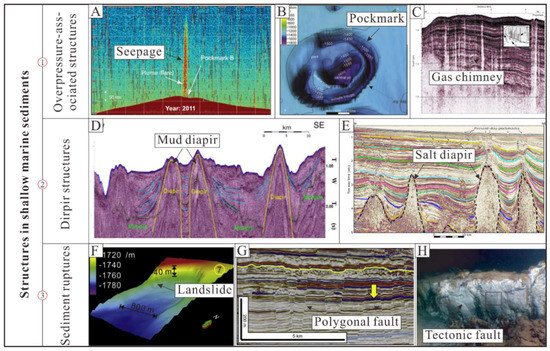
Figure 1. The classification of the structures developed in shallow marine sediments. (A) Seepage from bathymetry image, Vestnesa Ridge, west Svalbard margin, Norway (modified from Goswami et al. [29]); (B) Pockmark from bathymetry image, Zhongjiannan Basin, western margin of the South China Sea, China (modified from Lu et al. [23]); (C) Gas chimney from the seismic image, Cascadia margin, off the coast of Vancouver Island, Canada (modified from Wood et al. [30]); (D) Mud diapir from the seismic image, Lower Fangliao Basin, offshore SW Taiwan (modified from Hsu et al. [31]); (E) Salt diapir from the seismic image, upper Atlantic margin, SE Brazil (modified from de Mahiques et al. [32]); (F) Landslide from bathymetry image, Pearl River Mouth Basin, the northern slope of South China Sea (modified from Chen et al. [3]); (G) Polygonal fault from the seismic image, offshore Uruguay (modified from Turrini et al. [33]); (H) Tectonic fault from the sea-bottom picture, Tekirdag Basin, Sea of Marmara (modified from Armijo et al. [34]).
Diapir structures are soft-sediment deformations driven by differential gravity and compaction [35][36][37][38]. The soft plastic layers such as mud layers and salt layers easily extrude into overlying layers because of differential forces. Therefore, the mud diapir (Figure 1D) and the salt diapir (Figure 1E) are classified as diapir structures. The mud volcano and mud mound are also included in shallow marine structures in this study. The overpressure of the gas- and fluid-rich mud sediment is a critical driving force for their formation. In this study, we classify mud volcanoes and mud mounds as mud diapirs. The two structures are regarded as the later stage of the mud diapir. When the mud diapir reaches the seafloor, a conic-like structure formed is termed a mud volcano, and a dome-like structure is termed a mud mound.
Landslides (Figure 1F), polygonal faults (Figure 1G), and tectonic faults (Figure 1H) are driven by gravity, compaction forces and tectonic forces, respectively. All these structures have one or multiple prominent rupture surfaces; therefore, they are classified as sediment ruptures. The structural characteristics are usually different because they are not driven by a single force. The rupture surface is a reasonable connection that strings together the landslide, the polygonal fault, and the tectonic fault. In addition, the “shallow marine structure” is not restricted to a depth of less than 1000 mbsf due to the following considerations. First, the shallow marine structures are generally distributed in shallow unconsolidated marine sediments. Their structural characteristics are various and are easily influenced by many unpredictable factors. Second, some structures are developed in shallow and deep environments, and some structures are developed in a deep environment but extend into a shallow environment.
References
- Berton, F.; Vesely, F.F. Origin of buried, bottom current-related comet marks and associated submarine bedforms from a Paleogene continental margin, southeastern Brazil. Mar. Geol. 2018, 395, 347–362.
- Shakhova, N.; Semiletov, I.; Gustafsson, O.; Sergienko, V.; Lobkovsky, L.; Dudarev, O.; Tumskoy, V.; Grigoriev, M.; Mazurov, A.; Salyuk, A.; et al. Current rates and mechanisms of subsea permafrost degradation in the East Siberian Arctic Shelf. Nat. Commun. 2017, 8, 15872.
- Chen, D.; Wang, X.; Völker, D.; Wu, S.; Wang, L.; Li, W.; Li, Q.; Zhu, Z.; Li, C.; Qin, Z. Three dimensional seismic studies of deep-water hazard-related features on the northern slope of South China Sea. Mar. Pet. Geol. 2016, 77, 1125–1139.
- Matsumoto, R.; Hiromatsu, M.; Sato, M. Fluid flow and Evolution of gas hydrate mounds of Joetsu Basin, Eastern Margin of Japan Sea: Constraints from high-resolution geophysical survey by AUV. In Proceedings of the 7th International Conference on Gas Hydrate, Edinburgh, UK, 17–21 July 2011.
- Chen, S.-C.; Hsu, S.-K.; Wang, Y.; Chung, S.-H.; Chen, P.-C.; Tsai, C.-H.; Liu, C.-S.; Lin, H.-S.; Lee, Y.-W. Distribution and characters of the mud diapirs and mud volcanoes off southwest Taiwan. J. Asian Earth Sci. 2014, 92, 201–214.
- Ho, S.; Dan, C.; Imbert, P. Insights into the permeability of polygonal faults from their intersection geometries with Linear Chimneys: A case study from the Lower Congo Basin. Carnets Geol. 2016, 16, 17–26.
- Li, J.; Ye, J.; Qin, X.; Qiu, H.; Wu, N.; Lu, H.; Xie, W.; Lu, J.; Peng, F.; Xu, Z.; et al. The first offshore natural gas hydrate production test in South China Sea. China Geol. 2018, 1, 5–16.
- Sloan, E.D. Fundamental principles and applications of natural gas hydrates. Nature 2003, 426, 353.
- Lu, H.; Seo, Y.-T.; Lee, J.-W.; Moudrakovski, I.; Ripmeester, J.A.; Chapman, N.R.; Coffin, R.B.; Gardner, G.; Pohlman, J. Complex gas hydrate from the Cascadia margin. Nature 2007, 445, 303.
- Wei, J.; Fang, Y.; Lu, H.; Lu, H.; Lu, J.; Liang, J.; Yang, S. Distribution and characteristics of natural gas hydrates in the Shenhu Sea Area, South China Sea. Mar. Pet. Geol. 2018, 98, 622–628.
- Wei, J.; Liang, J.; Lu, J.; Zhang, W.; He, Y. Characteristics and dynamics of gas hydrate systems in the northwestern South China Sea—Results of the fifth gas hydrate drilling expedition. Mar. Pet. Geol. 2019, 110, 287–298.
- Ye, J.; Wei, J.; Liang, J.; Lu, J.; Lu, H.; Zhang, W. Complex gas hydrate system in a gas chimney, South China Sea. Mar. Pet. Geol. 2019, 104, 29–39.
- Berndt, C.; Feseker, T.; Treude, T.; Krastel, S.; Liebetrau, V.; Niemann, H.; Bertics, V.J.; Dumke, I.; Dünnbier, K.; Ferré, B. Temporal constraints on hydrate-controlled methane seepage off Svalbard. Science 2014, 343, 284–287.
- Biastoch, A.; Treude, T.; Rüpke, L.H.; Riebesell, U.; Roth, C.; Burwicz, E.B.; Park, W.; Latif, M.; Böning, C.W.; Madec, G. Rising Arctic Ocean temperatures cause gas hydrate destabilization and ocean acidification. Geophys. Res. Lett. 2011, 38.
- Boudreau, B.P.; Luo, Y.; Meysman, F.J.; Middelburg, J.J.; Dickens, G.R. Gas hydrate dissociation prolongs acidification of the Anthropocene oceans. Geophys. Res. Lett. 2015, 42, 9337–9344A.
- Skarke, A.; Ruppel, C.; Kodis, M.; Brothers, D.; Lobecker, E. Widespread methane leakage from the sea floor on the northern US Atlantic margin. Nat. Geosci. 2014, 7, 657–661.
- Han, W.-C.; Chen, L.; Liu, C.-S.; Berndt, C.; Chi, W.-C. Seismic analysis of the gas hydrate system at Pointer Ridge offshore SW Taiwan. Mar. Pet. Geol. 2019, 105, 158–167.
- Zhang, W.; Liang, J.; Su, P.; Wei, J.; Gong, Y.; Lin, L.; Liang, J.; Huang, W. Distribution and characteristics of mud diapirs, gas chimneys, and bottom simulating reflectors associated with hydrocarbon migration and gas hydrate accumulation in the Qiongdongnan Basin, northern slope of the South China Sea. Geol. J. 2019, 54, 3556–3573.
- Li, A.; Davies, R.J.; Mathias, S.A.; Yang, J.; Hobbs, R.; Wilson, M. Gas venting that bypasses the feather edge of marine hydrate, offshore Mauritania. Mar. Pet. Geol. 2017, 88, 402–409.
- Wenau, S.; Spieß, V.; Pape, T.; Fekete, N. Controlling mechanisms of giant deep water pockmarks in the Lower Congo Basin. Mar. Pet. Geol. 2017, 83, 140–157.
- Bei, K.; Xu, T.; Shang, S.; Wei, Z.; Yuan, Y.; Tian, H. Numerical Modeling of Gas Migration and Hydrate Formation in Heterogeneous Marine Sediments. J. Mar. Sci. Eng. 2019, 7, 348.
- Wang, X.; Liu, B.; Qian, J.; Zhang, X.; Guo, Y.; Su, P.; Liang, J.; Jin, J.; Luan, Z.; Chen, D. Geophysical evidence for gas hydrate accumulation related to methane seepage in the Taixinan Basin, South China Sea. J. Asian Earth Sci. 2018, 168, 27–37.
- Lu, Y.; Luan, X.; Lyu, F.; Wang, B.; Yang, Z.; Yang, T.; Yao, G. Seismic evidence and formation mechanism of gas hydrates in the Zhongjiannan Basin, Western margin of the South China Sea. Mar. Pet. Geol. 2017, 84, 274–288.
- Martínez-Carreño, N.; García-Gil, S. The Holocene gas system of the Ría de Vigo (NW Spain): Factors controlling the location of gas accumulations, seeps and pockmarks. Mar. Geol. 2013, 344, 82–100.
- Taylor, M.H.; Dillon, W.P.; Pecher, I.A. Trapping and migration of methane associated with the gas hydrate stability zone at the Blake Ridge Diapir: New insights from seismic data. Mar. Geol. 2000, 164, 79–89.
- Lastras, G.; Canals, M.; Urgeles, R.; Hughes-Clarke, J.E.; Acosta, J. Shallow slides and pockmark swarms in the Eivissa Channel, western Mediterranean Sea. Sedimentology 2004, 51, 837–850.
- Alrefaee, H.A.; Gosh, S.; Abdel-Fattah, M.I. 3D seismic characterization of the polygonal fault systems and its impact on fluid flow migration: An example from the Northern Carnarvon Basin, Australia. J. Pet. Sci. Eng. 2018, 167.
- Gasperini, L.; Polonia, A.; Bianco, F.D.; Favali, P.; Marinaro, G.; Etiope, G. Cold seeps, active faults and the earthquake cycle along the North Anatolian Fault system in the Sea of Marmara (NE Turkey). Boll. di Geofis. Teor. ed Appl. 2012, 53, 371–384.
- Goswami, B.K.; Weitemeyer, K.A.; Bünz, S.; Minshull, T.A.; Westbrook, G.K.; Ker, S.; Sinha, M.C. Variations in pockmark composition at the Vestnesa Ridge: Insights from marine controlled source electromagnetic and seismic data. Geochem. Geophys. Geosystems 2017, 18, 1111–1125.
- Wood, W.T.; Gettrust, J.F.; Chapman, N.R.; Spence, G.D.; Hyndman, R.D. Decreased stability of methane hydrates in marine sediments owing to phase-boundary roughness. Nature 2002, 420, 656.
- Hsu, H.-H.; Liu, C.-S.; Chang, Y.-T.; Chang, J.-H.; Ko, C.-C.; Chiu, S.-D.; Chen, S.-C. Diapiric activities and intraslope basin development offshore of SW Taiwan: A case study of the Lower Fangliao Basin gas hydrate prospect. J. Asian Earth Sci. 2017, 149, 145–159.
- de Mahiques, M.M.; Schattner, U.; Lazar, M.; Sumida, P.Y.; Souza, L.A. An extensive pockmark field on the upper Atlantic margin of Southeast Brazil: Spatial analysis and its relationship with salt diapirism. Heliyon 2017, 3, e00257.
- Turrini, L.; Jackson, C.A.L.; Thompson, P. Seal rock deformation by polygonal faulting, offshore Uruguay. Mar. Pet. Geol. 2017, 86, 892–907.
- Armijo, R.; Pondard, N.; Meyer, B.; Uçarkus, G.; Lépinay, B.M.D.; Malavieille, J.; Dominguez, S.; Gustcher, M.A.; Schmidt, S.; Beck, C. Submarine fault scarps in the Sea of Marmara pull-apart (North Anatolian Fault): Implications for seismic hazard in Istanbul. Geochem. Geophys. Geosystems 2013, 6, 453–468.
- Gamberi, F.; Rovere, M. Mud diapirs, mud volcanoes and fluid flow in the rear of the Calabrian Arc Orogenic Wedge (southeastern Tyrrhenian sea). Basin Res. 2010, 22, 452–464.
- Albertz, M.; Beaumont, C.; Shimeld, J.W.; Ings, S.J.; Gradmann, S. An investigation of salt tectonic structural styles in the Scotian Basin, offshore Atlantic Canada: 1. Comparison of observations with geometrically simple numerical models. Tectonics 2010, 29, TC4017.
- Vendeville, B.C. Salt tectonics driven by sediment progradation: Part I—Mechanics and kinematics. AAPG Bull. 2005, 89, 1071–1079.
- Al-Zoubi, A.; Uri, S. Salt diapirs in the Dead Sea basin and their relationship to Quaternary extensional tectonics. Mar. Pet. Geol. 2001, 18, 779–797.


