 +1 credit
| Version | Summary | Created by | Modification | Content Size | Created at | Operation |
|---|---|---|---|---|---|---|
| 1 | Alejandro Gomez-Pazo | + 3290 word(s) | 3290 | 2020-12-30 10:04:44 | | | |
| 2 | Vivi Li | + 64 word(s) | 3354 | 2021-01-06 10:47:38 | | | | |
| 3 | Vivi Li | Meta information modification | 3354 | 2021-01-06 10:48:42 | | |
Video Upload Options
This work analyzes the evolution of the large shifting dune included in the Corrubedo Natural Park from 1956 until the present day. The analysis was carried out using aerial images, orthophotographs, topographic surveys and LiDAR (Light Detection and Ranging) data. Variations were analyzed in terms of four different aspects: evolution of pathways in each period, changes in the position of the mobile dune front and the degree of vegetation cover, all between 1956 and 2017; and variations in elevation and volume of the dune system between 2001 and 2015. To analyze these aspects, geospatial and geostatistical techniques were employed, which revealed that the dune front had undergone two different phases: one until the 1980s, with a mean seaward advance of 32 m and another one between the 1980 s and 2017, when the front prograded to the continent, with an approximate mean advance of 82 m. Loss of volume, related to the expansion of the mobile dune towards the north, was confirmed in this sector. It is evident that these changes are closely linked to anthropic influence, due to sand extraction until the early 1990s and, more recently, due to an increase in the number of visitors to the Natural Park. The results obtained highlight the need to carry out detailed studies to understand the evolution of this system and to prevent further damage in the future. Moreover, based on these analyses, a strategy to improve coastal and environmental management in the Corrubedo Natural Park could be designed.
1. Introduction
Several publications have analyzed coastal dune systems, both at a global level and within Spain. Different authors have described the types of systems and their main characteristics [1][2][3][4]. Other works have focused on the dynamics and the evolution of these zones, particularly from a geomorphological point of view [5][6][7][8][9][10][11][12] but also paying attention to anthropic influence in these systems (e.g., References [13][14][15][16]). In this case the research focuses on an integrated analysis using different techniques in the large shifting dune within the Corrubedo Natural Park. This dune is 900 m long and 300 m wide and its maximum height is nearly 20 m. It is a singular formation in the Atlantic coast of the Iberian Peninsula.
Sedimentary systems are rapidly evolving environments, a fact with major implications both for the population and for economic sectors such as tourism [17]. In this sense and in relation to the potential impacts of global change, research about the evolution of sedimentary systems has become a key issue both for researchers and for society in general. The last few decades have seen an increase in the number of publications analyzing their evolution from multiple perspectives [18][19][20]. These variations are associated with technological advances, which have allowed researching this issue with a higher level of detail and accuracy [21][22][23].
The Corrubedo Natural Park is located in Galicia, a region in the NW Iberian Peninsula characterized by a very intricate coastline, with numerous inlets and outlets along more than 2100 km [24]. As the scale of analysis is expanded, the number of the different types of units identified increases. Among these, it is worth highlighting beach-dune systems, frequently associated with small lakes and marshlands, which constitute one of the most vulnerable coastal environments, as well as one of the most sensitive to human impact [25]. The study area could be included within this category. Overall, the Galician coast has been extensively analyzed from different perspectives in recent decades [26][27][28][29][30].
2. Results
2.1. Pathway Analysis
The analysis of variations in pathways around the mobile dune showed a clear increase since 1956, reaching their greatest length in 2002, with 11,201 m. These values remained above 7000 m until 2010, at which point their length decreased down to 4986 m in 2017 (Table 1).
| Date | Length (m) |
|---|---|
| 1956 | 1312 |
| 1983 | 8560 |
| 1989 | 11,132 |
| 2002 | 11,201 |
| 2004 | 9920 |
| 2008 | 7917 |
| 2010 | 7536 |
| 2014 | 5817 |
| 2017 | 4986 |
This evolution was clearly related to an increase in the area covered by vegetation in Corrubedo, almost non-existent in 1956, although the fact that only black and white images were available for this date made it more difficult to map. As shown in Figure 1, plant coverage has been considerably higher from 2000 onwards than in previous decades. These images also illustrate important changes in pathway distribution, which have reduced in recent years and moved southward from the mobile dune, towards the middle section of the beach. This could be related to protection and control measures.
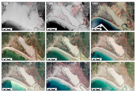
Figure 1. Evolution of pathways in the large shifting dune sector since 1956 to 2017. The pathways (red lines) are on the aerial images and orthophotographs of each data where one can observe the variations in dune extension (black dashed line). In the case of 1956 image, the dune extension is not marked for the difficult to define their boundaries in that image.
It is also worth noting that the aerial images from 2002 and 2004 (Figure 1) showed a pathway across the large shifting dune. This element corresponds to the installation of a wooden walkway in this area, later removed, although some signs of its presence still remain in later images.
2.2. Variations in the Dune Front between 1956 and 2017
The analysis of the mobile dune front provided an opportunity to clearly identify its advance towards the north, occupying an area that had been previously covered by dune vegetation at least since the 1980s. Related to this process and to the analyzed DSAS processes are major differences in its behavior between the period from 1956 to the 1980s, on one hand and the subsequent period, on the other. For the overall period, an average progradation of 32.37 m offshore took place but this dynamic was largely due to the expansion of the area covered by vegetation with respect to 1956, when plant coverage in this sector was much lower and sand dominated the study area (Figure 1). Conversely, analyzing variations since 1989, the front of the large sifting dune could be observed to progress 81 m towards the shore. This advance was also clearly noticeable in recent years, exceeding 30 m since 2004 (Figure 2).
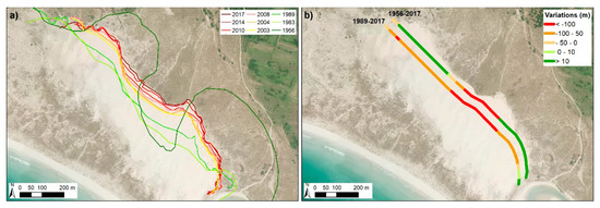
Figure 2. (a) represents the front dune line in each analyzed year and (b) shows the variations of these fronts between 1956 and 2017 and between 1989 and 2017. Positive values indicated an advance to seaward while negative values indicate a variation to landward.
2.3. Variations in Vegetation Coverage
Vegetation coverage in Corrubedo also varied greatly over the analyzed period (Table 2), from 33 ha in 1956 to a maximum value of 93.9 ha in 2017. This increase in plant coverage was not linear: this area has remained above 80 ha since 2002, unlike in previous decades, according to the images used (Figure 3). This increase in vegetation coverage in dune zones has also been observed both in other areas of Galicia [31] and at a global level [32]. This could be related to a decrease in sedimentary activity linked to an increase in temperature and nutrients along with a decrease in winds, which enables the expansion of vegetation in these sectors [32].
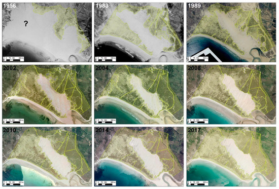
Figure 3. Evolution of vegetation coverage since 1956 to 2017. The light green polygons represent the vegetation on the aerial images and orthophotographs of each data. The symbol (?) in this part of the Figure indicated that in that moment (1956) was not possible identify the large dune extension and their boundaries.
Table 2. Vegetation surface (ha) in each analyzed image.
| Date | Surface (ha) |
|---|---|
| 1956 | 33.0 |
| 1983 | 67.0 |
| 1989 | 66.2 |
| 2002 | 84.9 |
| 2004 | 91.4 |
| 2008 | 92.9 |
| 2010 | 89.7 |
| 2014 | 88.1 |
| 2017 | 93.9 |
Additionally, it is worth highlighting that the accuracy of the definition of vegetation coverage based on older aerial images was lower, because coverage estimations always have a great uncertainty, especially in the case of the American flight (1956), where image quality complicates the delimitation of both the dune and the plant-covered area. In relation to the images, it is necessary to emphasize that the cartography based on images taken in different seasons, with the area having experienced different meteorological conditions in the months prior to image capture, can also lead to variations in the estimations due to the sand temporarily covering plants and to the seasonal behavior of some plant species.
Notwithstanding the foregoing, there has been a clear increase in plant coverage in recent years, which is perfectly consistent with the conclusions reached by other research studies [26][32].
2.4. Variations in Elevation Since 2001
Using data from the topographic surveys from 2001, from LiDAR (2008, 2010 and 2015) and from field visits during the last 20 years, an overall shoreward progradation of the dune could be observed, as already mentioned for the front dune. In this sense, a decrease in maximum elevation could be observed, with emerging evidence that the sediments are spreading northward, resulting in a decrease both in dune slope and in crest area. This advance leads to the fossilization of older plant-covered dune levels in some sectors (especially on the north side). Another effect was the progressive extension of the interdune corridor following an NNE-SSW direction, parallel to the dune crest, between it and the first level of plant-covered dunes located close to the beach (Figure 4 and Figure 5).
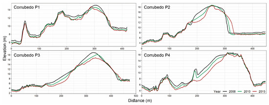
Figure 4. Topographic profiles in dune mobile sector between 2008 and 2015. The position of these profiles appears in Figure 8c in black color.
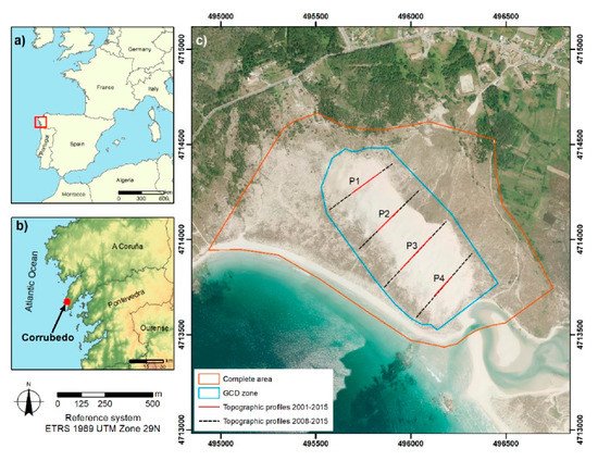
Figure 8. Location map of Natural Park of Corrubedo. 9 (a) represent the area in European context; (b) shows Corrubedo in west Galicia area; and (c) shows the large dune and the analysis zona in detail with the polygons used for analyzing the elevation differences (Geomorphic Change Detection (GCD) zone); the area to analyzed the pathways (Complete area) and the topographic profiles position above PNOA 2017 orthophotography [33].
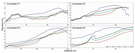
Figure 5. Topographic profiles in the crest of dune mobile sector between 2001 and 2015. The position of these profiles appears in Figure 8c in red color.
As shown in Figure 4, a decrease in dune elevation occurred during the 2008–2015 period, especially in the crest. While in 2001 the maximum elevation was 21 m, this elevation decreased to 20.31 m in 2008, 19.59 m in 2010 and 18.51 in 2015. These modifications were more relevant in the central zone of the mobile dune (Corrubedo P2 and P3 in Figure 4), which corresponds to the highest sector and the one with the greatest amount of sediments.
To analyze variations since 2001, the analysis focused on the peak sector of the dune system, about which abundant information is available. As shown in Figure 5, elevation decreased across all profiles. This fact is related to the erosion of the seaward flank and shoreward dune progradation.
The analysis of LiDAR data from 2008 onwards showed a general decrease in elevation in the whole analyzed sector. The overall results showed that erosion was the dominant process in the seaward dune flank. In the inner flank, large accumulations of sand transported to the crest by deflation channels were formed, leading to movements caused by gravity that helped slow the progression of the dune towards the shore (Figure 6). In Figure 6, a clear increase in elevation related to the advance of the mobile dune is shown in green. This dynamic appeared in the system in the 1980s.
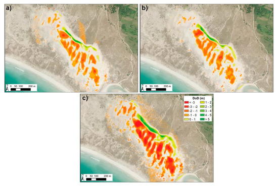
Figure 6. Evolution of surface elevation in large shifting dune sector. (a) Difference of Digital Elevation Models (DoD) between 2008 and 2010; (b) DoD between 2010 and 2015; and (c) DoD between 2008 and 2015.
Between 2008 and 2015, a −0.55 m decrease in average elevation could be observed. A 74.8% proportion of the area experienced variations above the LoD (0.5 m for this period) and 83% of this area experienced a decrease in elevation, resulting in a volume loss of 269,481 m3. In the partial analysis for the period between 2008 and 2010, the area that experienced variations was 32% and elevation decreased in 80% of this area, resulting in a net volume loss of 99,124 m3. The net variation in elevation was −0.2 m. Finally, in the 2010–2015 period, a similar decrease in elevation took place, with an average decrease of −0.23 m, although the area that experienced changes above the LoD increased up to 70.9%, with 75% of the area experiencing loss. The net balance of volumetric change in this case was −110,317 m3.
3. Discussion
Compared with other sectors of the Iberian coast, the Corrubedo zone shows lower levels of environmental degradation. However, this sector has not been spared the effects of certain human activities that damage, sometimes irreversibly, their geomorphological and, consequently, their ecological and landscape balance [25].
One of the most relevant anthropic elements in Corrubedo was sand extraction for the construction industry. This practice led to a great reduction in dune volume, which is very difficult to quantify; at the same time, the loss of plant coverage reactivated erosion processes [34][35]. This illustrates how anthropic activities can contribute to modify natural dynamics. According to the available information, the designation of the Natural Park took place at a time when sediment extraction seemed to be generalized in this area, although this practice has been prohibited in Spain since the approval of a Coastal Regulation Law in the 1980s. The areas that were most affected by this activity were those easily accessed, particularly in the northeastern section and in the vicinity of the estuary, where the effects of this activity are still observable in the presence of ponds.
The legal protection applied to Corrubedo led to an improvement from the environmental point of view, since it reduced the most harmful activities in this area. Nevertheless, there are still some environmental conservation issues related to the number of visitors and their influence on the ecosystems. The pathways generated during the late 1990s could clearly be observed in some delicate and singular sectors such as the mobile dune (Figure 1). These events decreased with the imposition of fines to any person trespassing the security boundaries and accessing the mobile dune, although nowadays footprints in the dune can often be observed.
3.1. Installation of a Walway over the Mobile Dune
One of the variations related to the anthropic activity analyzed in this sector was the installation of a wooden walkway over the mobile dune in early 2000 [36][37]. This structure crossed the dune at the bottom of a deflation corridor in its southern sector, close to the estuary, which was one of the main sediment sources. A preliminary analysis showed that the installation of this walkway, composed of 15 cm wide crosspieces, caused changes at a small scale. Although the structure was flexible, its location interrupted the path of sediments transported by saltation or rolling. When the wind blew in an oblique direction, one side of the walkway acted as an accumulation zone (oriental sector), while on the opposite side, a centimetric scarp was originated and became the starter to a large-scale erosion spot. This fact led to the systematic covering of the structure in some parts, a clear sign of the importance of eolian transport in this area, where sediments were channeled to the center of the system.
It is evident that the installation of such structure caused a major perturbation in sand mobilization and, consequently, in the dynamic evolution of the mobile dune for years. Its installation also entailed an increase in the accessibility to the dune crest sector, enhancing its attractive as a slide (Figure 7).
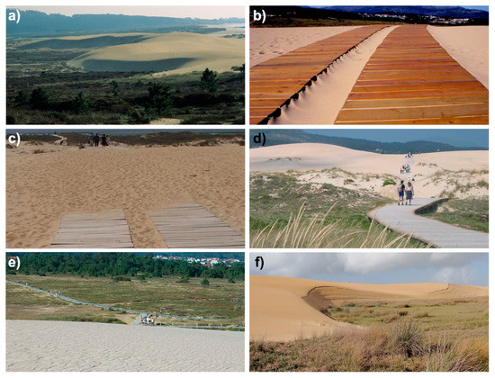
Figure 7. Evolution of large shifting dune sector in different moments. (a) shows the dune sector in 1992; (b) shows the walkway in early 2000; (c) shows the walkway in 2020 cover in part for the dune evolution; (d) shows visitants in the walkway across the dune in 2002; (e) reveals the ripples in the dune zone and the new walkway position, without the across dune section in 2006; and (f) shows the state of large shifting dune in the sector close to the walkway in 2012, that clearly represent their progression.
In 2006, analyzing the different morphological units in the Natural Park following the removal of the wooden walkway, a certain degree of restoration of a natural dynamic could be observed in this sector, with the appearance of several ripples (Technical report, unpublished). Other fact worth highlighting is the increasingly natural progradation front. Even in August, the month with the highest influx of visitors, virtually no footprints could be observed on the slope, which could be partly related to the stricter surveillance in this sector.
3.2. Historical Variations in Sedimentary Systems
Corrubedo is not a paradigmatic case in the Galician nor in the international context [15]. Variations in sedimentary sectors have been widely studied around the world. Generally, these are sectors of great interest for activities such as tourism and their modification could have important effects on the local population [17][38]. Recently, the evolution of the sedimentary system of Rodas beach in the Cíes Islands was analyzed [26]. This area is located 40 km to the south of Corrubedo, in the mouth of the ria of Vigo. The changes observed in this system in recent decades show some similarities, such as sand extraction activities and increasing numbers of visitors, whose influence was perceived in the pathways they generated on plant-covered dunes [39].
This area underwent a paradigm shift in the last decades. While in the late 20th century, the damaging activities affecting this system were related to productive industries, such as construction, agriculture and farming around the lagoon sector [25], nowadays the main impacts in the Corrubedo area are related to tourism. Its beautiful landscape, along with the promotion of its most distinctive ecosystems, led to an influx of visitors to an area of great ecological fragility. Along the same lines, it is worth emphasizing the importance that other factors could have, such as N and NE winds, whose influence has been reduced due to the presence of buildings and shrub vegetation in the inner sector, as well as variations in wind flow due to the topography and roughness of dune sectors. In terms of natural factors, the increasing frequency and intensity of storms will play a relevant role in the future of the Corrubedo Natural Park.
Another aspect that has not been assessed but which directly affects Galician dune systems, were oil cleaning activities after the Prestige oil spill in 2002. It is worth mentioning their potential effect on Corrubedo, an area that received a major amount of hydrocarbons that directly affected the dynamics of species found in this area [40]. Other activities indirectly affected the evolution of the Corrubedo area through cleaning tasks in the area, the use of heavy machinery, the increase in transit of people for cleaning tasks and modifications to the system with the installation of sand and plastic barriers in sensitive areas, such as the Vixán lagoon.
3.3. The Importance of Coastal Management in the Future
Management is a key element in order to protect the evolution of the Corrubedo Natural Park and to avoid potential damage to this area. In this sense, further research is needed to identify the issues that affect the natural behavior of these fragile ecosystems and to design measures for their conservation and protection. Furthermore, a close collaboration between scientists and the administration is essential, following examples in other geographical areas, such as the case of coastal management in Scotland [41]. This fact could help to develop plans and regulations adapted to the present and future dynamics of the Corrubedo area.
Since the creation of the Natural Park and despite the measures announced for its conservation, multiple issues are still present, leading to a decrease in the quality of this system. Notwithstanding the presence of informative panels outlining the allowed and prohibited activities, some visitors still ignore these guidelines. In the mobile dune area, despite the existence of a signposted walkway, some visitors cross the established boundaries to directly access the beach.
The inclusion of this area within the Natura 2000 network should have simultaneously entailed the monitoring of the system’s evolution. In line with the aforementioned, it is necessary to analyze the zones included within the protected area and their definition. In some of these sectors, the elements described in management plans do not fully match the actual elements present in the field, which is an obstacle for their correct management. In addition to the revision of the described categories and their adaptation to the current state of the area, a periodical revision of said categorization is also necessary given the high dynamism of these ecosystems [42][43].
All the studies about the influence of different factors on system dynamics should address possible changes in the future, along with global change and the increase in erosive elements [44][45]. The Corrubedo Natural Park is highly vulnerable to a rise in sea level and to the increasing intensity and frequency of marine storms [46]. New technologies for gathering information and continuous improvements in processing tools are crucial for a better management of this zone in the future. Detailed monitoring of the system’s evolution helps to design management measures adapted to its needs. The application of new monitoring techniques, such as unmanned aerial vehicle (UAV) flights [47][48] or the installation of fixed cameras [49] to measure variations, could constitute an excellent tool to improve the conservation of the Corrubedo Natural Park.
References
- Pye, K. Early post-depositional modification of aeolian dune sands. In Developments in Sedimentology; Elsevier: Amsterdam, The Netherlands, 1983; Volume 38, pp. 197–221. ISBN 0070-4571.
- Paskoff, R. Les dunes du littoral. Recherche (Paris 1970) 1989, 212, 888–895.
- Martínez, M.L.; Psuty, N.P.; Lubke, R.A. A perspective on coastal dunes. In Coastal Dunes; Springer: Berlin/Heidelberg, Germany, 2008; pp. 3–10.
- Hesp, P.A.; Walker, I. Coastal dunes. In Treatise on Geomorphology; Elsevier: Amsterdam, The Netherlands, 2013; pp. 328–355.
- Ritchie, W. The evolution of coastal sand dunes. Scott. Geogr. Mag. 1972, 88, 19–35.
- Arbogast, A.F.; Hansen, E.C.; Van Oort, M.D. Reconstructing the geomorphic evolution of large coastal dunes along the southeastern shore of Lake Michigan. Geomorphology 2002, 46, 241–255.
- Ojeda, J.; Vallejo, I.; Malvarez, G.C. Morphometric evolution of the active dunes system of the Doñana National Park, Southern Spain (1977–1999). J. Coast. Res. 2005, 49, 40–45.
- Pardo-Pascual, J.E.; García-Asenjo, L.; Palomar-Vázquez, J.; Garrigues-Talens, P. New methods and tools to analyze beach-dune system evolution using a Real-Time Kinematic Global Positioning System and Geographic Information Systems. J. Coast. Res. 2005, 49, 34–39.
- Fernandez, G.B.; Pereira, T.G.; da Rocha, T.B. Coastal dunes along Rio de Janeiro coast: Evolution and management. J. Coast. Res. 2009, 56, 307–311.
- Mathew, S.; Davidson-Arnott, R.G.D.; Ollerhead, J. Evolution of a beach–dune system following a catastrophic storm overwash event: Greenwich Dunes, Prince Edward Island, 1936–2005. Can. J. Earth Sci. 2010, 47, 273–290.
- Bossard, V.; Lerma, A.N. Geomorphologic characteristics and evolution of managed dunes on the South West Coast of France. Geomorphology 2020, 367, 107312.
- Molina, R.; Manno, G.; Lo Re, C.; Anfuso, G. Dune Systems’ Characterization and Evolution in the Andalusia Mediterranean Coast (Spain). Water 2020, 12, 2094.
- Nordstrom, K.F.; Jackson, N.L. Distribution of surface pebbles with changes in wave energy on a sandy estuarine beach. J. Sediment. Petrol. 1993, 63, 1152–1159.
- Paskoff, R. Typologie géomorphologique des milieux dunaires européens. Biodiversité Etprotection Dunaire Ates Du Colloq. Bordx. Paris 1997, 198–219.
- Cooper, J.A.G.; Alonso, I. Natural and anthropic coasts: Challenges for coastal management in Spain. J. Coast. Res. 2006, 48, 1–7.
- Ciccarelli, D.; Pinna, M.S.; Alquini, F.; Cogoni, D.; Ruocco, M.; Bacchetta, G.; Sarti, G.; Fenu, G. Development of a coastal dune vulnerability index for Mediterranean ecosystems: A useful tool for coastal managers? Estuar. Coast. Shelf Sci. 2017, 187, 84–95.
- Pagán, J.I.; Aragonés, L.; Tenza-Abril, A.J.; Pallarés, P. The influence of anthropic actions on the evolution of an urban beach: Case study of Marineta Cassiana beach, Spain. Sci. Total Environ. 2016, 559, 242–255.
- Pagán, J.I.; López, I.; Aragonés, L.; Garcia-Barba, J. The effects of the anthropic actions on the sandy beaches of Guardamar del Segura, Spain. Sci. Total Environ. 2017, 601–602, 1364–1377.
- Robin, N.; Billy, J.; Castelle, B.; Hesp, P.; Laporte-Fauret, Q.; Lerma, A.N.; Marieu, V.; Rosebery, D.; Bujan, S.; Destribats, B.; et al. Beach-dune Recovery from the Extreme 2013–2014 Storms Erosion at Truc Vert Beach, Southwest France: New Insights from Ground-penetrating Radar. J. Coast. Res. 2020, 95, 588–592.
- Ponte Lira, C.; Silva, A.N.; Taborda, R.; De Andrade, C.F. Coastline evolution of Portuguese low-lying sandy coast in the last 50 years: An integrated approach. Earth Syst. Sci. Data 2016, 8, 265–278.
- Taddia, Y.; Corbau, C.; Zambello, E.; Pellegrinelli, A. UAVs for structure-from-motion coastal monitoring: A case study to assess the evolution of embryo dunes over a two-year time frame in the po river delta, Italy. Sensors 2019, 19, 1717.
- Guisado-Pintado, E.; Jackson, D.W.T.; Rogers, D. 3D mapping efficacy of a drone and terrestrial laser scanner over a temperate beach-dune zone. Geomorphology 2019, 328, 157–172.
- Kankara, R.S.; Selvan, S.C.; Markose, V.J.; Rajan, B.; Arockiaraj, S. Estimation of long and short term shoreline changes along Andhra Pradesh coast using remote sensing and GIS techniques. Procedia Eng. 2015, 116, 855–862.
- POLGalicia Plan de Ordenación do Litoral de Galicia; Consellaría de Medio Ambiente, Territorio e Infraestruturas: Santiago de Compostela, Spain, 2010.
- Fraga-Santiago, P.; Gómez-Pazo, A.; Pérez-Alberti, A.; Montero, P.; Otero Pérez, X.L. Trends in the Recent Evolution of Coastal Lagoons and Lakes in Galicia (NW Iberian Peninsula). J. Mar. Sci. Eng. 2019, 7, 272.
- Gomez-Pazo, A.; Perez-Alberti, A.; Otero Pérez, X.L. Recent Evolution (1956–2017) of Rodas Beach on the Cíes Islands, Galicia, NW Spain. J. Mar. Sci. Eng. 2019, 7, 125.
- Gómez-Pazo, A.; Pérez-Alberti, A.; Trenhaile, A. Recording inter-annual changes on a boulder beach in Galicia, NW Spain using an unmanned aerial vehicle. Earth Surf. Process. Landf. 2019, 44, 1004–1014.
- Trenhaile, A.S.; Perez-Alberti, A.; Martínez-Cortizas, A.; Costa-Casais, M.; Blanco-Chao, R. Rock coast inheritance: An example from Galicia, northwestern Spain. Earth Surf. Process. Landf. 1999, 24, 605–621.
- Horacio, J.; Muñoz-Narciso, E.; Trenhaile, A.S.; Pérez-Alberti, A. Remote sensing monitoring of a coastal-valley earthflow in northwestern Galicia, Spain. Catena 2019, 178, 276–287.
- Feal-Pérez, A.; Blanco-Chao, R.; Ferro-Vázquez, C.; Martínez-Cortizas, A.; Costa-Casais, M. Late-Holocene storm imprint in a coastal sedimentary sequence (Northwest Iberian coast). Holocene 2014, 24, 477–488.
- Otero, X.L.; Macías, F. Estudio para la sostenibilidad de la laguna de Baldaio y su entorno (A Coruña). In Litoral, Ordenación y Modelos de Futuro: IV Congreso de Ingeniería Civil, Territorio y Medio Ambiente; Dirección General de Costas; Ministerio de Medio Ambiente: Madrid, Spain, 2010.
- Jackson, D.W.T.; Costas, S.; González-Villanueva, R.; Cooper, A. A global ‘greening’ of coastal dunes: An integrated consequence of climate change? Glob. Planet. Chang. 2019, 182, 103026.
- Instituto Geográfico Nacional (IGN). 2020. Available online: https://www.centrodedescargas.cnig.es/ (accessed on 10 November 2020).
- Meur-Férec, C. Géomorphologie, Protection et Gestion Des Dunes de Bretagne Septentrionale: Éléments de Comparaison Avec D’autres Régions de la Manche Occidentale: Cotentin, Devon et Cornwall (RU). Ph.D. Thesis, Université de Bretagne Occidentale, Brest, France, 1993.
- Bodere, J.C.; Hallegouet, B. Le cordon de Treffiagat (Finistere Sud): Les consequences d’une explotation abusive des sables dunaire. In Proceedings of the Les dunes Littorales et Leur Aménagement, Paris, France, 3 February 1990; pp. 45–56.
- Pérez-Alberti, A.; Vázquez Paz, M. Caracterización y dinámica de sistemas dunares costeros de Galicia. In Las Dunas de España; Scoiedad Española de Geomorfología: Zaragoza, Spain, 2011; pp. 161–185.
- Vázquez Paz, M.; Pérez-Alberti, A. Análisis dinámico y medioambiental de un espacio protegido en la costa atlántica (Parque Natural de Corrubedo, A Coruña). Xeográfica Rev. Xeogr. Territ. Medio Ambient. 2002, 2, 155–178.
- Roig-Munar, F.X. Microerosión inducida por los usuarios de las playas. El caso de Menorca (Islas Baleares). Investig. Geogr. 2007, 43, 161–167.
- Costas, S.; Alejo, I.; Alcántara-Carrió, J. Human Influence on the Evolution of Islas Cíes Sand Barrier (NW Spain). In The Changing Coast; Eurocoast/EUCC: Porto, Portugal, 2002; pp. 283–287.
- Junoy, J.; Castellanos, C.; Viéitez, J.M.; Riera, R. Seven years of macroinfauna monitoring at Ladeira beach (Corrubedo Bay, NW Spain) after the Prestige oil spill. Oceanologia 2013, 55, 393–407.
- Fitton, J.M.; Hansom, J.D.; Rennie, A.F. A method for modelling coastal erosion risk: The example of Scotland. Nat. Hazards 2018, 91, 931–961.
- Kovac, M.; Hladnik, D.; Kutnar, L. Biodiversity in (the Natura 2000) forest habitats is not static: Its conservation calls for an active management approach. J. Nat. Conserv. 2018, 43, 250–260.
- Vanden Borre, J.; Paelinckx, D.; Mücher, C.A.; Kooistra, L.; Haest, B.; De Blust, G.; Schmidt, A.M. Integrating remote sensing in Natura 2000 habitat monitoring: Prospects on the way forward. J. Nat. Conserv. 2011, 19, 116–125.
- Pickering, M.D.; Horsburgh, K.J.; Blundell, J.R.; Hirschi, J.J.M.; Nicholls, R.J.; Verlaan, M.; Wells, N.C. The impact of future sea-level rise on the global tides. Cont. Shelf Res. 2017, 142, 50–68.
- Le Cozannet, G.; Bulteau, T.; Castelle, B.; Ranasinghe, R.; Wöppelmann, G.; Rohmer, J.; Bernon, N.; Idier, D.; Louisor, J.; Salas-y-Mélia, D. Quantifying uncertainties of sandy shoreline change projections as sea level rises. Sci. Rep. 2019, 9, 1–11.
- Gómez-Pazo, A.; Pérez-Alberti, A. Vulnerability of the Galician coast to marine storms in the context of global change. Sémata Cienc. Sociais Hum. 2017, 29, 117–142.
- Turner, I.L.; Harley, M.D.; Drummond, C.D. UAVs for coastal surveying. Coast. Eng. 2016, 114, 19–24.
- Green, D.R.; Hagon, J.J.; Gómez, C.; Gregory, B.J. Using Low-Cost UAVs for Environmental Monitoring, Mapping, and Modelling: Examples From the Coastal Zone. In Coastal Management, Global Challenges and Innovations; Academic Press: London, UK, 2019.
- Harley, M.D.; Kinsela, M.A.; Sánchez-García, E.; Vos, K. Shoreline change mapping using crowd-sourced smartphone images. Coast. Eng. 2019, 150, 175–189.


