This work analyzes the evolution of the large shifting dune included in the Corrubedo Natural Park from 1956 until the present day. The analysis was carried out using aerial images, orthophotographs, topographic surveys and LiDAR (Light Detection and Ranging) data. Variations were analyzed in terms of four different aspects: evolution of pathways in each period, changes in the position of the mobile dune front and the degree of vegetation cover, all between 1956 and 2017; and variations in elevation and volume of the dune system between 2001 and 2015. To analyze these aspects, geospatial and geostatistical techniques were employed, which revealed that the dune front had undergone two different phases: one until the 1980s, with a mean seaward advance of 32 m and another one between the 1980 s and 2017, when the front prograded to the continent, with an approximate mean advance of 82 m. Loss of volume, related to the expansion of the mobile dune towards the north, was confirmed in this sector. It is evident that these changes are closely linked to anthropic influence, due to sand extraction until the early 1990s and, more recently, due to an increase in the number of visitors to the Natural Park. The results obtained highlight the need to carry out detailed studies to understand the evolution of this system and to prevent further damage in the future. Moreover, based on these analyses, a strategy to improve coastal and environmental management in the Corrubedo Natural Park could be designed.
- coastal dune
- Corrubedo
- Galicia
- Coastal evolution
1. Introduction
Several publications have analyzed coastal dune systems, both at a global level and within Spain. Different authors have described the types of systems and their main characteristics [1,2,3,4]. Other works have focused on the dynamics and the evolution of these zones, particularly from a geomorphological point of view [5,6,7,8,9,10,11,12] but also paying attention to anthropic influence in these systems (e.g., References [13,14,15,16]). In this case the research focuses on an integrated analysis using different techniques in the large shifting dune within the Corrubedo Natural Park. This dune is 900 m long and 300 m wide and its maximum height is nearly 20 m. It is a singular formation in the Atlantic coast of the Iberian Peninsula.
Sedimentary systems are rapidly evolving environments, a fact with major implications both for the population and for economic sectors such as tourism [17]. In this sense and in relation to the potential impacts of global change, research about the evolution of sedimentary systems has become a key issue both for researchers and for society in general. The last few decades have seen an increase in the number of publications analyzing their evolution from multiple perspectives [18,19,20]. These variations are associated with technological advances, which have allowed researching this issue with a higher level of detail and accuracy [21,22,23].
The Corrubedo Natural Park is located in Galicia, a region in the NW Iberian Peninsula characterized by a very intricate coastline, with numerous inlets and outlets along more than 2100 km [24]. As the scale of analysis is expanded, the number of the different types of units identified increases. Among these, it is worth highlighting beach-dune systems, frequently associated with small lakes and marshlands, which constitute one of the most vulnerable coastal environments, as well as one of the most sensitive to human impact [25]. The study area could be included within this category. Overall, the Galician coast has been extensively analyzed from different perspectives in recent decades [26,27,28,29,30].
2. Results
2.1. Pathway Analysis
The analysis of variations in pathways around the mobile dune showed a clear increase since 1956, reaching their greatest length in 2002, with 11,201 m. These values remained above 7000 m until 2010, at which point their length decreased down to 4986 m in 2017 (Table 3).
| Date | Length (m) |
|---|---|
| 1956 | 1312 |
| 1983 | 8560 |
| 1989 | 11,132 |
| 2002 | 11,201 |
| 2004 | 9920 |
| 2008 | 7917 |
| 2010 | 7536 |
| 2014 | 5817 |
| 2017 | 4986 |
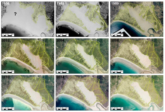
This evolution was clearly related to an increase in the area covered by vegetation in Corrubedo, almost non-existent in 1956, although the fact that only black and white images were available for this date made it more difficult to map. As shown in Figure 4, plant coverage has been considerably higher from 2000 onwards than in previous decades. These images also illustrate important changes in pathway distribution, which have reduced in recent years and moved southward from the mobile dune, towards the middle section of the beach. This could be related to protection and control measures.
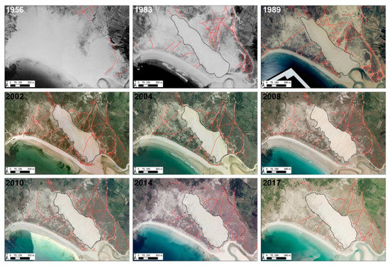
It is also worth noting that the aerial images from 2002 and 2004 (Figure 4) showed a pathway across the large shifting dune. This element corresponds to the installation of a wooden walkway in this area, later removed, although some signs of its presence still remain in later images.
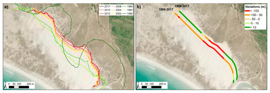
2.2. Variations in the Dune Front between 1956 and 2017
2.3. Variations in Vegetation Coverage
| Date | Surface (ha) |
|---|---|
| 1956 | 33.0 |
| 1983 | 67.0 |
| 1989 | 66.2 |
| 2002 | 84.9 |
| 2004 | 91.4 |
| 2008 | 92.9 |
| 2010 | 89.7 |
| 2014 | 88.1 |
| 2017 | 93.9 |
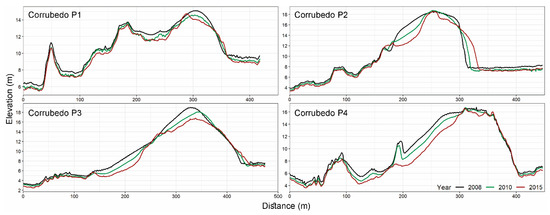
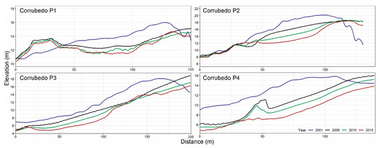
2.4. Variations in Elevation Since 2001
3. Discussion
Compared with other sectors of the Iberian coast, the Corrubedo zone shows lower levels of environmental degradation. However, this sector has not been spared the effects of certain human activities that damage, sometimes irreversibly, their geomorphological and, consequently, their ecological and landscape balance [25].
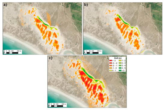
One of the most relevant anthropic elements in Corrubedo was sand extraction for the construction industry. This practice led to a great reduction in dune volume, which is very difficult to quantify; at the same time, the loss of plant coverage reactivated erosion processes [41,50]. This illustrates how anthropic activities can contribute to modify natural dynamics. According to the available information, the designation of the Natural Park took place at a time when sediment extraction seemed to be generalized in this area, although this practice has been prohibited in Spain since the approval of a Coastal Regulation Law in the 1980s. The areas that were most affected by this activity were those easily accessed, particularly in the northeastern section and in the vicinity of the estuary, where the effects of this activity are still observable in the presence of ponds.
The legal protection applied to Corrubedo led to an improvement from the environmental point of view, since it reduced the most harmful activities in this area. Nevertheless, there are still some environmental conservation issues related to the number of visitors and their influence on the ecosystems. The pathways generated during the late 1990s could clearly be observed in some delicate and singular sectors such as the mobile dune (Figure 4). These events decreased with the imposition of fines to any person trespassing the security boundaries and accessing the mobile dune, although nowadays footprints in the dune can often be observed.
3.1. Installation of a Walway over the Mobile Dune
One of the variations related to the anthropic activity analyzed in this sector was the installation of a wooden walkway over the mobile dune in early 2000 [33,42]. This structure crossed the dune at the bottom of a deflation corridor in its southern sector, close to the estuary, which was one of the main sediment sources. A preliminary analysis showed that the installation of this walkway, composed of 15 cm wide crosspieces, caused changes at a small scale. Although the structure was flexible, its location interrupted the path of sediments transported by saltation or rolling. When the wind blew in an oblique direction, one side of the walkway acted as an accumulation zone (oriental sector), while on the opposite side, a centimetric scarp was originated and became the starter to a large-scale erosion spot. This fact led to the systematic covering of the structure in some parts, a clear sign of the importance of eolian transport in this area, where sediments were channeled to the center of the system.
It is evident that the installation of such structure caused a major perturbation in sand mobilization and, consequently, in the dynamic evolution of the mobile dune for years. Its installation also entailed an increase in the accessibility to the dune crest sector, enhancing its attractive as a slide (Figure 10).
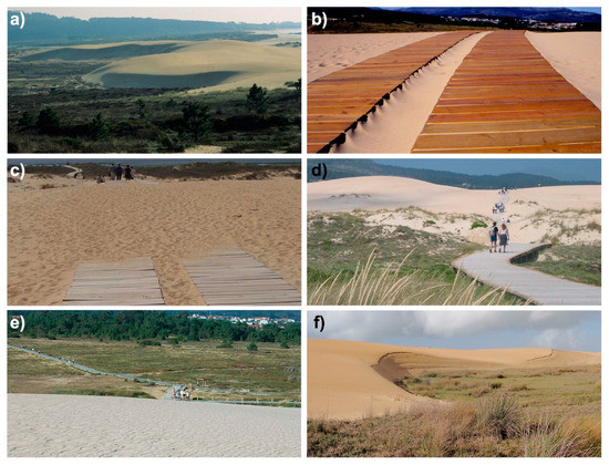
In 2006, analyzing the different morphological units in the Natural Park following the removal of the wooden walkway, a certain degree of restoration of a natural dynamic could be observed in this sector, with the appearance of several ripples (Technical report, unpublished). Other fact worth highlighting is the increasingly natural progradation front. Even in August, the month with the highest influx of visitors, virtually no footprints could be observed on the slope, which could be partly related to the stricter surveillance in this sector.
3.2. Historical Variations in Sedimentary Systems
Corrubedo is not a paradigmatic case in the Galician nor in the international context [15]. Variations in sedimentary sectors have been widely studied around the world. Generally, these are sectors of great interest for activities such as tourism and their modification could have important effects on the local population [17,51]. Recently, the evolution of the sedimentary system of Rodas beach in the Cíes Islands was analyzed [26]. This area is located 40 km to the south of Corrubedo, in the mouth of the ria of Vigo. The changes observed in this system in recent decades show some similarities, such as sand extraction activities and increasing numbers of visitors, whose influence was perceived in the pathways they generated on plant-covered dunes [52].
This area underwent a paradigm shift in the last decades. While in the late 20th century, the damaging activities affecting this system were related to productive industries, such as construction, agriculture and farming around the lagoon sector [25], nowadays the main impacts in the Corrubedo area are related to tourism. Its beautiful landscape, along with the promotion of its most distinctive ecosystems, led to an influx of visitors to an area of great ecological fragility. Along the same lines, it is worth emphasizing the importance that other factors could have, such as N and NE winds, whose influence has been reduced due to the presence of buildings and shrub vegetation in the inner sector, as well as variations in wind flow due to the topography and roughness of dune sectors. In terms of natural factors, the increasing frequency and intensity of storms will play a relevant role in the future of the Corrubedo Natural Park.
Another aspect that has not been assessed but which directly affects Galician dune systems, were oil cleaning activities after the Prestige oil spill in 2002. It is worth mentioning their potential effect on Corrubedo, an area that received a major amount of hydrocarbons that directly affected the dynamics of species found in this area [53]. Other activities indirectly affected the evolution of the Corrubedo area through cleaning tasks in the area, the use of heavy machinery, the increase in transit of people for cleaning tasks and modifications to the system with the installation of sand and plastic barriers in sensitive areas, such as the Vixán lagoon.
3.3. The Importance of Coastal Management in the Future
Management is a key element in order to protect the evolution of the Corrubedo Natural Park and to avoid potential damage to this area. In this sense, further research is needed to identify the issues that affect the natural behavior of these fragile ecosystems and to design measures for their conservation and protection. Furthermore, a close collaboration between scientists and the administration is essential, following examples in other geographical areas, such as the case of coastal management in Scotland [54]. This fact could help to develop plans and regulations adapted to the present and future dynamics of the Corrubedo area.
Since the creation of the Natural Park and despite the measures announced for its conservation, multiple issues are still present, leading to a decrease in the quality of this system. Notwithstanding the presence of informative panels outlining the allowed and prohibited activities, some visitors still ignore these guidelines. In the mobile dune area, despite the existence of a signposted walkway, some visitors cross the established boundaries to directly access the beach.
The inclusion of this area within the Natura 2000 network should have simultaneously entailed the monitoring of the system’s evolution. In line with the aforementioned, it is necessary to analyze the zones included within the protected area and their definition. In some of these sectors, the elements described in management plans do not fully match the actual elements present in the field, which is an obstacle for their correct management. In addition to the revision of the described categories and their adaptation to the current state of the area, a periodical revision of said categorization is also necessary given the high dynamism of these ecosystems [55,56].
All the studies about the influence of different factors on system dynamics should address possible changes in the future, along with global change and the increase in erosive elements [57,58]. The Corrubedo Natural Park is highly vulnerable to a rise in sea level and to the increasing intensity and frequency of marine storms [59]. New technologies for gathering information and continuous improvements in processing tools are crucial for a better management of this zone in the future. Detailed monitoring of the system’s evolution helps to design management measures adapted to its needs. The application of new monitoring techniques, such as unmanned aerial vehicle (UAV) flights [60,61] or the installation of fixed cameras [62] to measure variations, could constitute an excellent tool to improve the conservation of the Corrubedo Natural Park.
This entry is adapted from the peer-reviewed paper 10.3390/app11010034