Submitted Successfully!
To reward your contribution, here is a gift for you: A free trial for our video production service.
Thank you for your contribution! You can also upload a video entry or images related to this topic.
Version Summary Created by Modification Content Size Created at Operation
1 + 4386 word(s) 4386 2021-05-17 10:56:39 |
2 format change Meta information modification 4386 2021-05-24 03:47:44 |

Video Upload Options

Do you have a full video?

Confirm

Are you sure to Delete?
Cite
If you have any further questions, please contact Encyclopedia Editorial Office.
Juniyanti, L. Driving Forces of Land Change. Encyclopedia. Available online: https://encyclopedia.pub/entry/9944 (accessed on 24 April 2024).
Juniyanti L. Driving Forces of Land Change. Encyclopedia. Available at: https://encyclopedia.pub/entry/9944. Accessed April 24, 2024.
Juniyanti, Lila. "Driving Forces of Land Change" Encyclopedia, https://encyclopedia.pub/entry/9944 (accessed April 24, 2024).
Juniyanti, L. (2021, May 21). Driving Forces of Land Change. In Encyclopedia. https://encyclopedia.pub/entry/9944
Juniyanti, Lila. "Driving Forces of Land Change." Encyclopedia. Web. 21 May, 2021.
Driving Forces of Land Change
Edit

Indonesia has experienced one of the world’s greatest dynamic land changes due to forestry and agricultural practices. Understanding the drivers behind these land changes remains challenging, partly because landscape research is spread across many domains and disciplines. Our review shows that oil palm expansion is the most prominent among multiple direct causes of land change. We determined that property rights are the most prominent issue among the multiple underlying causes of land change. Distinct combinations of mainly economic, institutional, political, and social underlying drivers determine land change, rather than single key drivers. Our review also shows that central and district governments as decision-making actors are prominent among multiple land change actors. Our systematic review indicates knowledge gaps that can be filled by clarifying the identification and role of actors in land change.

actors direct causes land change PRISMA diagram tropical deforestation underlying causes

1. Introduction

Changes in land cover (biophysical attributes of the earth’s surface) and land use (human purpose or intent applied to these attributes) are so pervasive that, when aggregated globally, they significantly affect crucial aspects of the earth system functioning [1]. Tropical lowland regions in many parts of the world have experienced large land-use changes, leading to a decline in forest areas, while the area used for agricultural production has increased [2]. Land changes in the tropics significantly affect food security [3]. The loss of natural forests has resulted in the decline of values from several ecosystem services [4].
Indonesia is a tropical country with the world’s highest CO2 emissions from the processes of land change [5]. Agricultural expansion and forest exploitation have played an essential role in intensive land use management throughout Indonesia over the past few decades [6][7]. Understanding land-change causes and actors are one of the prime goals of global change research [3][8][9]. The concept of driving forces has distinguished direct causes and underlying causes of land change. The direct causes are the activities of actors that directly affect land use [10]. The extension and intensification of plantations are a direct cause of deforestation of primary forests in tropical areas [11]. The expansion of agriculture and forestry by large companies is creating significant land change [12]. Direct causes of land change have been influenced or determined by a more fundamental force, called underlying causes. Underlying causes are fundamental societal processes that drive the proximate causes, either operating at the local level or indirectly from a higher level [8]. Forestry and agricultural policies that regulate land allocation are the underlying causes that determine land change [3][13]. The Indonesian government supports large-scale land use through policies because this scheme is considered capable of improving the country’s economic and development conditions [14].
Actors play a special role because actors are responsible for, and play an important role in, the driving forces of land change. Actors make decisions, act accordingly, and influence other actors and the environment with their actions [9]. Most countries in Africa and Southeast Asia show that land-use systems controlled by the government lead to land use dominated by large companies through permits [15][16]. Indonesia also makes state claims on forest cover through the Forest Use Agreement (TGHK), strengthening the central government’s position in controlling the use of state forest areas for companies; therefore, an understanding of the power of actors in land-use arrangements is important as a bridge to exploring options for improving land management [17].
The various causes that drive land change in the area reflect global trends and regional peculiarities, depending on social and ecological conditions; however, understanding the drivers of land change has its challenges. A robust variety of studies on these themes exist but have limited relevance due to their scope and context [18]. Local-level studies are particular in their contexts, actors, main processes, scale, and resolution [19]. Based on the uniqueness of the local landscape and the causes of its changes, the use of a comparative framework will be useful to allow more generalized insight that can be transferred across places [20]. Systematic reviews provide a robust and more comprehensive picture based on multiple studies and settings compared to a single study and provide context for interpreting the results of new primary studies [18]. This systematic review technique is also a promising approach for integrating and considering land change at a local scale into land change at a more general level [21].
Several systematic reviews on a global scale have been carried out and resulted in invaluable insights into the landscape approach [22], deforestation [21][23][24] land tenure security [25], agricultural intensification in the tropics [26], climate effects, and habitat loss [27], urban land [28], and wetlands conversion [13]; however, studies that synthesize the causes of land change on a national scale, particularly in areas with the highest land-change dynamics in Indonesia, have not been carried out. Over the past several decades, Sumatra and Kalimantan have been the areas with the most significant land change in Indonesia [14][29]. From 1985 to 1997, forest loss in Sumatra and Kalimantan was above the average for forest loss in Indonesia as a whole, and became the largest contributor to tree cover loss in Indonesia during the 2001–2019 period [7]; therefore, in our study, we chose Sumatra and Kalimantan as the study areas, as they are the areas with the largest forestry and plantation operations in Indonesia.

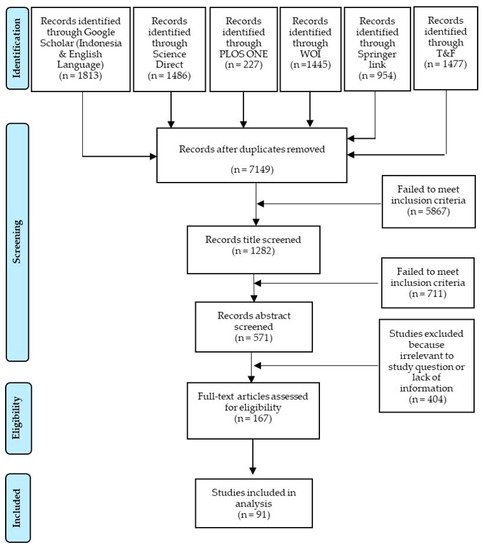
2. Selection of the Articles

After compiling the list of references, researchers further screened each article to decide whether it should be included for data extraction and analysis [30]. The screening process and quality assessment were carried out in two stages: (1) selection of primary studies based on titles and abstracts; and (2) assessment based on the full text of the study. This screening and quality assessment process referred to the inclusion criteria (Table 1). The process is shown in the Preferred Reporting Items for Systematic Reviews and Meta-Analyses (PRISMA) diagram in Figure 1, which includes the number of studies identified during the search, screening, and quality assessment process.
Figure 1. A PRISMA diagram depicting the screening process and quality assessment of each publication.

3. Agricultural and Forestry Practices as Direct Causes of Land Change

The diagram represents the sum of each sub-category of direct causes of land change in Sumatra and Kalimantan from the total studies analyzed (Figure 2). The expansion of agricultural areas has been by far the main direct cause of land change in Sumatra and Kalimantan. The activities that led to the most changes in the land were oil palm plantations (agricultural expansion sub-category) and wood extraction and timber plantations (forest expansion sub-category). Although shifting cultivation is not a dominant direct cause, shifting cultivation and wood extraction are distributed throughout the province. Oil palm and timber plantations that led to the most changes can be found in all provinces except North Kalimantan. North Kalimantan is a new province resulting from the division of East Kalimantan; thus, the direct causes of land change occurring in this region can be seen in the eastern province.

Diagram of direct causes of land change in Sumatra and Kalimantan.
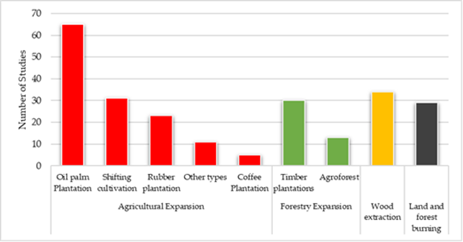
Figure 2. Diagram of direct causes of land change in Sumatra and Kalimantan.

The highest proportion of oil palm plantations are found in Riau Province (86.7%). Based on data from the Sub Directorate of Plantation Statistics in 2018, the total area of oil palm plantations in Riau represented Indonesia’s largest land-use type. The highest proportion of wood extraction operations are concentrated in the province of South Kalimantan (80%); this form of land use comprises wood extraction activities carried out by companies with forest concession rights (Hak Pengusahaan Hutan/HPH) or illegal logging by specific individuals. Agroforestry, coffee, and rubber plantations were the least important causes of land change. The highest proportions of agroforestry (19.5%) and rubber plantations (43.9%) were located in Jambi Province. The highest frequency for coffee plantation activities, 26.7%, can be found in studies located in Lampung.

Agriculture is the primary land use globally because half of the world’s habitable land is used for agriculture [5][31]. This condition shows that the leading direct causes of land change in Indonesia are the same as the global trend. This finding is also reinforced by several previous studies stating that the direct cause of land change in countries globally, including Indonesia, is agricultural expansion [8][13][32]. Oil palm is one of the most strategic commodities due to the high demand in various countries worldwide. Currently, Indonesia is the world’s largest palm oil producer [5], with an area of oil palm plantations in Indonesia to date reaching nearly 15 million hectares [33]. The plantation sector is also one of the largest contributors to gross domestic product (GDP), accounting for 0.29% amidst a GDP contraction rate of 5.32% [34].
The positive growth in the development of the oil palm industry has ignored the prevailing regulations and negative externalities resulting from the development of oil palm plantations. The licensing of oil palm plantations often does not comply with applicable legal procedures There are several stages of the legal procedures. First, investors must submit permits consisting of location permits, environmental impact analysis (AMDAL), and environmental permits sequentially to local governments. Second, when implementing the AMDAL and environmental permits, a boundary setting is carried out by the NLA and release approval of forest area by the MoEF. Third, with the completeness of the AMDAL permit, environmental permit, and forest release permit, investors apply for a Plantation Business Permit (IUP) to the local government. Fourth, investors apply for Business Use Rights (HGU) to NLA on the condition that they have obtained an IUP and a forest area release permit. Local governments provide permits for oil palm plantations within forest concessions [32]. The rapid development of oil palm also influences land conflicts between communities or between communities and companies [35] and is closely related to corrupt practices through licensing [36][37].
In the forestry sector, important direct causes have led to land changes such as wood extraction and timber plantations. Wood extraction from forests on a large scale took place in Indonesia starting in the 1960s after the government issued the Forest Concession Rights (HPH) policy [38]. In the 1970s, HPH reached its peak, by which time the government-military relationship was powerful. The military has the privilege of carrying out large-scale logging business activities (HPH) [39] and is at the forefront of maintaining conservation forests [40]. Logging on a large scale has resulted in a logged-over area (LOA) that has become a quasi-open access area vulnerable to conflicts due to mutual claims from certain actors. LOAs with lower productivity than primary forests are very vulnerable to being claimed and converted to other uses [14].
Apart from companies, illegal wood extraction is also carried out by a particular party. The existence of HPHs at the site level under state permits raises the issue of illegal logging, that is, logging by parties without state permits. Illegal timber does generate new job opportunities for local people, but their labor force can be easily exploited. People want to be involved in illegal activities to earn wages; however, they still depend on middlemen for equipment and transportation, making local people vulnerable to exploitation [40], trapping them in this line of work and poverty. Unstable political conditions (post-reform and decentralization) have led to rampant illegal logging; illegal timber is even exported to various countries worldwide [40].
Timber production from natural forests has declined worldwide since the late 1980s [41] and has been replaced by forest plantations, which accounted for approximately 51% of the world’s industrial roundwood production in 2018 [42]. The rapid development of forest plantations has made Indonesia one of the top 10 producers of forest plantation products (round wood, pulp for paper, paper, and paperboard) [42]. In Indonesia, timber plantation (Hutan Tanaman Industri/HTI) development begins with utilizing a logged-over area (LOA) using government subsidies from reforestation funds. However, HTI development is mostly carried out in productive forests. Companies logs in productive areas through timber utilization permits (IPK) as input in HTI development [43]. This fact shows that the companies greatly benefit from obtaining subsidies for HTI development and at the same time obtaining income from the use of wood from productive forests.

4. Institutional and Policy Factors as Underlying Causes of Land Change

The higher proportions related to institutional factors were property rights issues and lack of institutional capacity (Figure 3). The issue of property rights is the dominant underlying cause of land change in Riau Province, at 46.7%. Lack of institutional capacity was distributed throughout the provinces of Sumatra and Kalimantan. West Kalimantan is the province with the highest proportion (52.6%) of institutions responsible for land governance. Apart from institutional factors, policy factors are also a leading cause of land change activities. Jambi is the province with the highest proportion of transmigration policy, at 41.5%
Diagram of underlying causes of land change in Sumatra and Kalimantan.
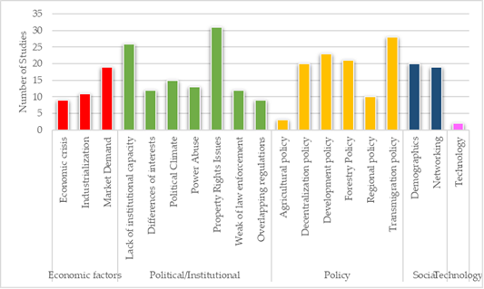
Figure 3. Diagram of underlying causes of land change in Sumatra and Kalimantan.
Our study revealed that institutional factors (e.g., property rights issues and lack of institutional capacity) and policy factors (transmigration policy) are the most important underlying causes of land change in Sumatra and Kalimantan. These two factors are also the leading causes of land change in various countries. Institutional factors have become critical underlying causes of land change in some parts of Europe [20]. The policy is also a significant factor and an underlying cause of land change in Latin America, Africa, and Southeast Asia [44].
Property rights issues, as the leading underlying causes of land change in Sumatra and Kalimantan, are related to land resource management history, especially in the forestry sector. The Draft Regulation of the Government of the Republic of Indonesia regarding the Settlement of Inconsistencies between Spatial Planning and Forest Areas, Permits, and/or Land Rights indicates that 40.97% of Indonesia’s territory overlaps. Unilateral claims by the state have been made since the Dutch colonial era; the government issued an Agrarian Decree that stated that all land that other parties could not prove to be property was the state domain (domainverklaring) [45]. Government policies in land allocation, especially forest areas, still maintain the domain-converting ideology as a form of state control over resources. This ideology is reflected in the Basic Forestry Law Number 1967, which states that forest area is based on its function throughout Indonesia and is listed in the Forest Use Agreement (TGHK) in 1986.
The government’s forest area claims are not accompanied by clear forest area boundary demarcation at the site level. Social mapping is not considered to determine whether management has been carried out by the community long before the stipulation of TGHK. This creates confusing boundaries between state forests and community-managed areas. Forest land use and allocation are problematic because they often overlap with traditional and customary claims by local communities [46][47][48]. The unfinished forest gazettement process at the site level has resulted in a ‘gray’ area and has become an area of conflict for various parties. The situation of unclear land ownership also encourages illegal cutting of natural forest [49]; forest conversion is also possible because of the need to assert control over land under tenure insecurity conditions (certainty of rights).
The issue of land ownership is also related to the lack of institutional capacity [50][51]. Provincial and local governments cannot implement regulations properly, particularly trial licenses for non-forest land (APL), many parts of which are managed by local communities. The license itself did not follow GR No. 7/1990, requiring that industrial team-related plantations be established on state forestland [32]. The provincial government also implements rules in use and rules in form, meaning that the government has ruled at the site level, which can differ from the existing rules in form. These rules are often incompatible with their duties and functions in field governance. An institution cannot carry out its functions properly because there are people who “mess up” the duties and functions of the government. For this reason, district or sub-district officials gain greater control over forest resources and go beyond their official legal authority [31].
The government also failed to recognize the people living in forest areas and gave permits to large companies without considering the community’s management. The government does not pay attention to the reality of state forest areas in the field but symbolically observes its legality through the available means [52]. Government Regulation No. 59 of 1997 concerning land registration has controlled the granting of rights to communities that occupy state land. Article 24 paragraph (2) states that the government recognizes an applicant’s property rights when the applicant and their predecessors have physically occupied a parcel of land for 20 years or more consecutively by the applicant. The fact is that the government has not been able to implement the process properly, governing land acquisition is unclear, and the government would not address the problems of in-generational displacement [53].
The weakness of state control and supervision makes it difficult to identify actors that must be dealt with in a targeted manner; these failings allow for the perpetuation of crime. Actors who do not have many choices due to limited resources choose to take illegal actions because of past experience that violations are not fatal and provide benefits (rational choice). Violations can also be committed by people who have many choices because the punishment for violating norms or laws and regulations can be borne by their resources [54]. Weak law enforcement encourages power abuse by government actors and rent-seeking behavior such as by entrepreneurs. These behaviors will continue to be replicated because their benefits are far greater than the negative impacts they receive.
The transmigration policy is also an example of the government’s weakness in implementing its policy products that are directly related to land management in forest areas. The government provided ±2 hectares of land for settlement and agricultural development for transmigrant communities [55]. Plantation development by transmigrants was expected to be a source of economic benefit for transmigrants; therefore, Sumatra and Kalimantan, as the target areas for the transmigration program, experienced massive forest conversion after the transmigration program was implemented [56].
During the development of the transmigration program, the government also encouraged the industrialization of natural resource management, including large-scale plantations; the government developed Nucleus Estate Smallholder (NES) for transmigrant communities to accelerate the development of monoculture plantations by collaborating with large companies. The NES program was first introduced for rubber plantations [57]. This program was quite effective in accelerating the development of monoculture plantations; however, in the end, NES was not popular because the contracts between the companies and farmers were often unclear, which in turn created conditions of economic distress for the communities [58].
The unclear area allocated to migrants for cultivation has caused uncontrolled land clearing. Migrants were clearing land on a large scale for the development of plantation crops [57]. The non-transparent land allocation and unclear boundaries of transmigration areas with local communities have also caused social conflict among communities. Social jealousy in local communities encourages participation in land clearing by burning as a form of land claim.
Community socio-cultural changes due to the transmigration program were also not well-anticipated by the government. The success of migrants in managing their land attracted spontaneous transmigrants to claim land illegally. The expansion of the regional economy due to the development of plantation areas has encouraged the arrival of newcomers to clear natural forests by burning as a form of land claim [37][59]. Transmigrants who did not get land access have to go through a long, high-cost administrative process to own land recognized by the state, so they choose instead to clear land by burning.
The transmigration program’s domino effect, which encouraged spontaneous transmigrants/newcomers to migrate, became one of the important factors that led to the conversion of natural forests into agricultural and plantation areas. Land in Sumatra and Kalimantan is not only subject to conversion pressure from transmigrants and large-scale companies, but also spontaneous transmigrants/newcomers, which are difficult for the government to monitor. For example, in 2019, one of the peat hydrological unit areas on the island of Sumatra only had a forest area of less than 10% due to the conversion carried out by 90% of the migrants from Java [60].
In contrast to the two previous factors, technology is the least common cause of land change. Technology in plantation development includes quality seeds and new technical knowledge in management. In practice, farmers find it difficult to obtain quality seeds, which causes low productivity [12]. Low productivity compels farmers to extend their plantation areas to achieve desired production. In addition, not everyone can access information about good management techniques in developing oil palm; therefore, communities continue to clear land by burning to expand their plantation area. Land is cleared by burning because this is the most effective and efficient method.

5. The Most Prominent Actor in Land Change in Indonesia

The driving forces are the forces that, together with the actors, shape land change. In this study, we extracted information on the actors identified in the literature categorized as decision-making actors, direct land change actors, and supporting actors. The systematic review results showed that decision-making actors and direct land change actors are the most discussed in the literature (Figure 4). In the category of decision-making actors, the central and local governments are the main actors that play a role in land change through their political activities, e.g., granting land management permits. The government’s role is translated into policy and institutional factors that are the most influential underlying causes in the land change process.
The “elite” decision-making actors are actors from a certain network that ensures control of land outside existing formal control or by bringing their land interests under formal control. Direct land change actors consist of farmers, private companies, public companies, and traditional landowners. The traditional landowner is indigenous people who own and manage land based on traditional law. In this category, farmers (landowners and managers, both residents and migrants) and private companies are the most influential land management actors in Sumatra and Kalimantan.
Diagram of land change actors in Sumatra and Kalimantan.
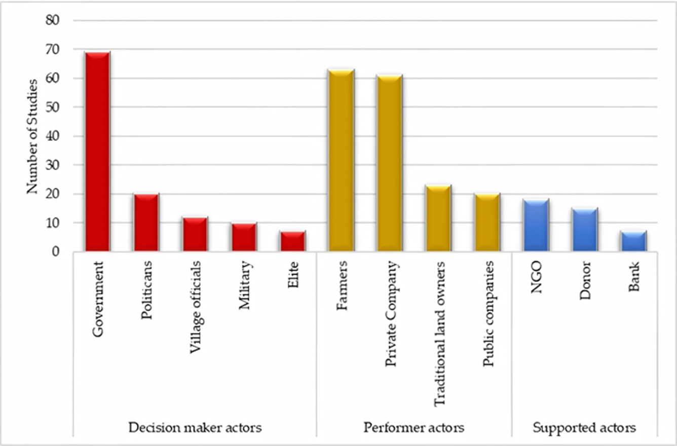
Figure 4. Diagram of land change actors in Sumatra and Kalimantan.
Donor agencies and banks fall into the category of supporting actors, as they support government programs related to land resource management through grants or loans. During the period of state development, the Indonesian state and donor agencies initiated a strategy for agricultural development in transmigration areas. Non-governmental organizations (NGOs) and research institutions are actors that seek to support improvements in land governance by raising awareness and supporting the strengthening of civil society as well as providing decision-makers with options for improving land use.
Indonesia’s current forest and land governance systems assign various responsibilities to district, provincial, and national authorities. Land allocation is regulated by the Ministry of Environment and Forestry (MoEF) and the National Land Agency (NLA); the MoEF controls forest areas, whereas the NLA manages non-forest areas [48]. Based on Law Number 32 of 2004 concerning Regional Government, the implementation of operational land management (forest areas and outside forest areas) lies with the district and provincial governments [51][61][62]
The institution that is responsible for controlling land governance has not been able to carry out its functions effectively for several reasons: (1) power abuse is closely related to violations of applicable regulations and corruption; (2) the inability of the institution to see land management at the site level; and (3) weak coordination between related institutions, which can be caused by conflicts of interest. Power abuse relates to actors who have dynamic and ambiguous identities, which at one time represent public interests and at other times represent private interests, allowing authorities to use their publicly derived powers to fulfill their own interests [63]. The authorized institution sees that the truth in policy is determined more by legal default (based on the legal documents) than the truth at the site level, resulting in the neglect of pre-existing management options [52].
Land use issues are often answered by formulating policies that are not accompanied by implementation of the proper legal products from the policymakers and implementers themselves. Legal development comprises the renewal of legal products and their exemplary implementation by the authorized institutions. The weakness of such a regulatory agency provides opportunities for actors at the site level, including companies and communities, to undertake “informal land management”. Governments that have great control over land allocation without effective performance from government agencies (legal institutions, local governments, central government etc.) are a cause of prolonged conflicts [64][65].
Government control over land allocation through policies does not reflect actual control at the site level. Actors tend to be opportunistic by making maximum use of policies and ignoring existing legal regulations because these regulations have never actually worked effectively. Village elites, communities, and brokers form networks to manage land allocation at the site level without legal mechanisms [40][66]. These actors are, in fact, the most powerful at the site level in controlling land use.

6. Limitations and the Strength of the Study

A systematic review can provide a full, more comprehensive picture based on multiple studies and settings than a single study [18]; however, relevant information reported in the empirical studies used may be lost. We selected only peer-reviewed journals that contained specific electronic databases that matched our English and Indonesian search words. Other studies that focused more on land change processes but did not meet our criteria were not included in this study. Despite these limitations, this study provides an overview derived from multiple single studies, originating from multiple study periods and across regions, that were robust in the local context and provided in-depth explanations of the processes and leading causes of land change. For Indonesia, as one of the countries with the most significant deforestation rates and CO2 emissions (from land use) in the world [5], the generalization is fundamental as a basis for improving land management systems. This systematic review also provides a broad and deep understanding of existing research, allowing future researchers to advance our land use knowledge.

7. The Future of Land Governance and Systematic Review Research

This systematic review of land change can provide an overview of the causes and associated actors driving the dynamic changes in land in Sumatra and Kalimantan. It is necessary to develop a systematic review of land change using a quantitative approach, known as a meta-analysis, and to expand the scope of the literature analyzed both in the type of search database and the type of literature: for example, comparing findings in the peer-reviewed literature with the grey literature [22].
The large number of legal products used to control land governance, without any assignment from the government itself as the policymaker to ensure compliance with the implementation process, has resulted in unclear management at the site level. Policymakers only set policies based on specific regulations without being able to see the reality on the ground. Rent seekers exploit this problem by managing land beyond formal control [52]; therefore, policy implementation must consider the social realities in land management. Problems in the field do not always have to be answered with a uniform legal product. Still, the government supports the resource instruments needed to improve governance through strong actors at the site level.

References

  1. Lambin, E.F.; Turner, B.L.; Geist, H.J.; Agbola, S.B.; Angelsen, A.; Folke, C.; Bruce, J.W.; Coomes, O.T.; Dirzo, R.; George, P.S.; et al. The Causes of Land-Use and Land-Cover Change: Moving beyond the Myths. Glob. Environ. Chang. 2001, 11, 261–269.
  2. Gatto, M.; Wollni, M.; Qaim, M. Land Use Policy Oil Palm Boom and Land-Use Dynamics in Indonesia: The Role of Policies and Socioeconomic Factors. Land Use Policy 2015, 46, 292–303.
  3. Lambin, E.F.; Geist, H.J.; Lepers, E. Dynamics of Land-Use and Land-Cover Chane in Tropical Regions. Annu. Rev. Environ. Resour. 2003, 205–241.
  4. Kindu, M.; Schneider, T.; Teketay, D.; Knoke, T. Science of the Total Environment Changes of Ecosystem Service Values in Response to Land Use/Land Cover Dynamics in Munessa—Shashemene Landscape of the Ethiopian Highlands. Sci. Total Environ. 2016, 547, 137–147.
  5. FAOSTAT. FAOSTAT Statistical Database; FAOSTAT: Rome, Italy, 2020.
  6. Marlier, M.E.; Defries, R.; Pennington, D.; Nelson, E. Future Fire Emissions Associated with Projected Land Use Change in Sumatra. Glob. Chang. Biol. 2015, 21, 345–362.
  7. Wicke, B.; Sikkema, R.; Dornburg, V.; Faaij, A. Exploring Land Use Changes and the Role of Palm Oil Production in Indonesia and Malaysia. Land Use Policy 2011, 28, 193–206.
  8. Geist, H.J.; Lambin, E.F. Proximate Causes and Underlying Driving Forces of Tropical Deforestation. Bioscience 2002, 52, 143–150.
  9. Hersperger, A.M.; Gennaio, M.; Verburg, P.H. Linking Land Change with Driving Forces and Actors: Four Conceptual. Ecol. Soc. 2010, 15, 1–17.
  10. Contreras-Hermosilla, A. The Underlying Causes of Forest Decline; Center for International Forestry Research: Bogor, Indonesia, 2000; Volume 30.
  11. Walker, R. Theorizing Land-Cover and Land-Use Change: The Case of Tropical Deforestation. Int. Reg. Sci. Rev. 2004, 27, 247–270.
  12. McCarthy, J.F. Processes of Inclusion and Adverse Incorporation: Oil Palm and Agrarian Change in Sumatra, Indonesia. J. Peasant Stud. 2010, 37, 821–850.
  13. Van Asselen, S.; Verburg, P.H.; Vermaat, J.E.; Janse, J.H. Drivers of Wetland Conversion: A Global Meta-Analysis. PLoS ONE 2013, 8.
  14. Abood, S.A.; Lee, J.S.H.; Burivalova, Z.; Garcia-Ulloa, J.; Koh, L.P. Relative Contributions of the Logging, Fiber, Oil Palm, and Mining Industries to Forest Loss in Indonesia. Conserv. Lett. 2015, 8, 58–67.
  15. Durand-Lasserve, A.; Royston, L. Holding Their Ground: Secure Land Tenure for the Urban Poor in Developing Countries; Earthscan Publications Ltd.: London, UK, 2002.
  16. Morrison, E.; Dubois, O. Sustainable Livelihoods in Upland Vietnam: Land Allocation and Beyond; International Institute for Environment and Development: London, UK, 1998.
  17. Bohnet, I.C.; Roebeling, P.C.; Williams, K.J.; Holzworth, D.; van Grieken, M.E.; Pert, P.L.; Kroon, F.J.; Westcott, D.A.; Brodie, J. Landscapes Toolkit: An Integrated Modelling Framework to Assist Stakeholders in Exploring Options for Sustainable Landscape Development. Landsc. Ecol. 2011, 26, 1179.
  18. Gough, D.; Oliver, S.; Thomas, J. An Introduction to Systematic Reviews; SAGE Publications Ltd.: London, UK, 2017.
  19. Bürgi, M.; Hersperger, A.M.; Schneeberger, N. Driving Forces of Landscape Change—Current and New Directions. Landsc. Ecol. 2004, 19, 857–868.
  20. Plieninger, T.; Bieling, C.; Kizos, T.; Martin, M.G. Pan-European Systematic Review and Meta-Analysis; HERCULES: Berlin, Germany, 2014.
  21. Rudel, T.K. Meta-Analyses of Case Studies: A Method for Studying Regional and Global Environmental Change. Glob. Environ. Chang. 2008, 18, 18–25.
  22. Reed, J.; van Vianen, J.; Barlow, J.; Sunderland, T. Land Use Policy Have Integrated Landscape Approaches Reconciled Societal and Environmental Issues in the Tropics? Land Use Policy 2017, 63, 481–492.
  23. Wehkamp, J.; Koch, N.; Lübbers, S.; Fuss, S. Governance and Deforestation—A Meta-Analysis in Economics. Ecol. Econ. 2018, 144, 214–227.
  24. Hunter, R.F.; Cleland, C.; Cleary, A.; Droomers, M.; Wheeler, B.W.; Sinnett, D.; Nieuwenhuijsen, M.J.; Braubach, M. Environmental, Health, Wellbeing, Social and Equity Effects of Urban Green Space Interventions: A Meta-Narrative Evidence Synthesis. Environ. Int. 2019, 130, 104923.
  25. Higgins, D.; Balint, T.; Liversage, H.; Winters, P. Investigating the Impacts of Increased Rural Land Tenure Security: A Systematic Review of the Evidence. J. Rural Stud. 2018, 61, 34–62.
  26. Keys, E.; Mcconnell, W.J. Meta-Analysis of Agricultural Change in the Tropics Global Change and the Intensification of Agriculture in the Tropics. Glob. Environ. Chang. 2016, 15, 320–337.
  27. Mantyka-Pringle, C.S.; Martin, T.G.; Rhodes, J.R. Interactions between Climate and Habitat Loss Effects on Biodiversity: A Systematic Review and Meta-Analysis. Glob. Chang. Biol. 2012, 18, 1239–1252.
  28. Seto, K.C.; Fragkias, M.; Guneralp, B.; Reilly, M.K. A Meta-Analysis of Global Urban Land Expansion. PLoS ONE 2011, 6, 1–9.
  29. Margono, B.A.; Turubanova, S.; Zhuravleva, I.; Potapov, P.; Tyukavina, A. Mapping and Monitoring Deforestation and Forest Degradation in Sumatra (Indonesia) Using Landsat Time Series Data Sets from 1990 to 2010. Environ. Commun. J. Nat. Cult. 2012, 7, 034010.
  30. Xiao, Y.; Watson, M. Guidance on Conducting a Systematic Literature Review. J. Plan. Educ. Res. 2019, 39, 93–112.
  31. Sandker, M.; Suwarno, A.; Campbell, B.M. Will Forests Remain in the Face of Oil Palm Expansion? Simulating Change in Malinau, Indonesia. Ecol. Soc. 2007, 12, 1–37.
  32. Prabowo, D.; Maryudi, A.; Senawi; Imron, M.A. Conversion of Forests into Oil Palm Plantations in West Kalimantan, Indonesia: Insights from Actors’ Power and Its Dynamics. For. Policy Econ. 2017, 78, 32–39.
  33. Directorate General of Estates. Tree Crop Estate Statistic of Indonesia 2018–2020; Ministry of Agriculture: Jakarta, Indonesia, 2020.
  34. Badan Pusat Statistik. Pertumbuhan Ekonomi Indonesia Triwulan III-2020; BPS: Jakarta, Indonesia, 2020.
  35. Hariyadi, B.; Ticktin, T. From Shifting Cultivation to Cinnamon Agroforestry: Changing Agricultural Practices Among the Serampas in the Kerinci Seblat National Park, Indonesia. Hum. Ecol. 2012, 40, 315–325.
  36. Directorate General of Estate Crops. Tree Crop Estate Statistics of Indonesia 2018–2020: Rubber; Ministry of Agriculture: Jakarta, Indonesia, 2019.
  37. Suyanto, S.; Applegate, G.; Permana, R.P.; Khususiyah, N.; Kurniawan, I. The Role of Fire in Changing Land Use and Livelihoods in Riau-Sumatra. Ecol. Soc. 2004, 9, 15.
  38. Linkie, M.; Smith, R.J.; Leader-Williams, N. Mapping and Predicting Deforestation Patterns in the Lowlands of Sumatra. Biodivers. Conserv. 2004, 13, 1809–1818.
  39. Lamb, D. Reforestation, Conservation and Livelihoods. In Regreening the Bare Hills: Tropical Forest Restoration in the Asia-Pacific Region; Springer: Dordrecht, The Netherlands, 2011; pp. 93–134.
  40. Casson, A.; Obidzinski, K. From New Order to Regional Autonomy: Shifting Dynamics of ‘Illegal’ Logging in Kalimantan, Indonesia. World Dev. 2002, 30, 2133–2151.
  41. Warman, R.D. Global Wood Production from Natural Forests Has Peaked. Biodivers. Conserv. 2014, 23, 1063–1078.
  42. FAO Statistics. Forest Products 2018; Food and Griculture Organization of the United Nations: Rome, Italy, 2020.
  43. Obidzinski, K.; Chaudhury, M. Transition to Timber Plantation Based Forestry in Indonesia: Towards a Feasible New Policy. Int. For. Rev. 2009, 11, 79–87.
  44. Lambin, E.F.; Geist, H.J. Regional Differences in Tropical Deforestation. Environ. Sci. Policy Sustain. Dev. 2003, 45, 22–36.
  45. Peluso, N.L. Hutan Kaya, Rakyat Melarat: Penguasaan Sumber Daya Dan Perlawanan Di Jawa; Khopalindo: Yogyakarta, Indonesia, 2006.
  46. Maryudi, A. The Contesting Aspirations in the Forests: Actors, Interests and Power in Community Forestry in Java; Universitätsdrucke Göttingen: Göttingen, Germany, 2011.
  47. Galudra, G.; Van Noordwijk, M.; Agung, P.; Suyanto, S.; Pradhan, U. Migrants, Land Markets and Carbon Emissions in Jambi, Indonesia: Land Tenure Change and the Prospect of Emission Reduction. Mitig. Adapt. Strateg. Glob. Chang. 2014, 19, 715–731.
  48. Sahide, M.A.K.; Giessen, L. The Fragmented Land Use Administration in Indonesia—Analysing Bureaucratic Responsibilities Influencing Tropical Rainforest Transformation Systems. L. Use Policy 2015, 43, 96–110.
  49. Indrabudi, H.; De Gier, A.; Fresco, L.O. Deforestation and Its Driving Forces: A Case Study of Riam Kanan Watershed, Indonesia. L. Degrad. Dev. 1998, 9, 311–322.
  50. Handayani, T. Legalitas Surat Keterangan Tanah Yang Dikeluarkan Oleh Kepala Desa Sebagai Dasar Transaksi Jual Beli Tanah; North Sumatera University: Medan, Indonesia, 2016.
  51. Intan, D.G. Penyelesaian Konflik Pertanahan Di Provinsi Lampung. Keadilan Progresif 2011, 2, 184–195.
  52. Khan, A.; Nugroho, B.; Suharjito, D.; Darusman, D.; VZuhud, E.A.; Hardjanto; Kartodihardjo, H.; Hendrayanto; Shohibudin, M.; Sardjono, M.A.; et al. Masalah Cara Pikir Dan Praktek Kehutanan: Refleksi Dan Evaluasi II. In Kembali ke Jalan Lurus: Kritik Penggunaan Ilmu dan Praktik Kehutanan Indonesia; Kartodihardjo, H., Ed.; FORCI Development dan Tanah Air Beta: Yogyakarta, Indonesia, 2013; p. 504.
  53. Li, T.M. Intergenerational Displacement in Indonesia’s Oil Palm Plantation Zone. J. Peasant Stud. 2017, 1–19.
  54. Kartodihardjo, H. Analisis Kebijakan Pengelolaan Sumber Daya Alam; Firdaus Pressindo: Yogyakarta, Indonesia, 2017.
  55. Miyamoto, M. Forest Conversion to Rubber around Sumatran Villages in Indonesia: Comparing the Impacts of Road Construction, Transmigration Projects and Population. For. Policy Econ. 2006, 9, 1–12.
  56. Imbernon, J. Changes in Agricultural Practice and Landscape over a 60-Year Period in North Lampung, Sumatra. Agric. Ecosyst. Environ. 1999, 76, 61–66.
  57. Feintrenie, L.; Chong, W.K.; Levang, P. Why Do Farmers Prefer Oil Palm? Lessons Learnt from Bungo District, Indonesia. Small-scale For. 2010, 9, 379–396.
  58. Rist, L.; Feintrenie, L.; Levang, P. The Livelihood Impacts of Oil Palm: Smallholders in Indonesia. Biodivers. Conserv. 2010, 19, 1009–1024.
  59. Tsujino, R.; Yumoto, T.; Kitamura, S.; Djamaluddin, I.; Darnaedi, D. History of Forest Loss and Degradation in Indonesia. Land Use Policy 2016, 57, 335–347.
  60. Juniyanti, L.; Prasetyo, L.B.; Aprianto, D.P.; Purnomo, H.; Kartodihardjo, H. Land-Use/Land Cover Change and Its Causes in Bengkalis Island, Riau Province (from 1990-2019). J. Nat. Resour. Environ. Manag. 2020, 10, 419–434.
  61. Brockhaus, M.; Obidzinski, K.; Dermawan, A.; Laumonier, Y.; Luttrell, C. An Overview of Forest and Land Allocation Policies in Indonesia: Is the Current Framework Sufficient to Meet the Needs of REDD+? For. Policy Econ. 2012, 18 (Suppl. C), 30–37.
  62. Wibowo, L.R.; Hakim, I.; Komarudin, H.; Kurniasari, D.R.; Wicaksono, D.; Okarda, B. Penyelesaian Tenurial Perkebunan Kelapa Sawit Di Kawasan Hutan Untuk Kepastian Investasi Dan Keadilan; Working Paper; 247; CIFOR: Bogor, Indonesia, 2019.
  63. Feintrenie, L.; Levang, P. Sumatra’s Rubber Agroforests: Advent, Rise and Fall of a Sustainable Cropping System. Small-Scale For. 2009, 8, 323–335.
  64. Villamor, G.B.; Pontius, R.G.; van Noordwijk, M. Agroforest’s Growing Role in Reducing Carbon Losses from Jambi (Sumatra), Indonesia. Reg. Environ. Chang. 2014, 14, 825–834.
  65. Potter, L. Resource Periphery, Corridor, Heartland: Contesting Land Use in the Kalimantan/Malaysia Borderlands. Asia Pacific Viewp. 2009, 50, 88–106.
  66. McCarthy, J.F. Changing to Gray: Decentralization and the Emergence of Volatile Socio-Legal Configurations in Central Kalimantan, Indonesia. World Dev. 2004, 32, 1199–1223.
More
Information
Contributor MDPI registered users' name will be linked to their SciProfiles pages. To register with us, please refer to https://encyclopedia.pub/register :
View Times: 1.8K
Entry Collection: Environmental Sciences
Revisions: 2 times (View History)
Update Date: 24 May 2021
1000/1000