 +1 credit
| Version | Summary | Created by | Modification | Content Size | Created at | Operation |
|---|---|---|---|---|---|---|
| 1 | Zhifeng Liu | + 2244 word(s) | 2244 | 2020-11-02 07:41:33 | | | |
| 2 | Lily Guo | Meta information modification | 2244 | 2020-11-09 05:31:41 | | |
Video Upload Options
Regional Hydro-Ecological Simulation System (RHESSys), a distributed physical processes-based ecohydrological model, that can simulate the regional multi-components cycle of nitrogen, carbon, and water. Many RHESSys-based studies have been implemented for sustainable watershed management.
1. Introduction
RHESSys has a hierarchical structure with three main modules that allow hydrological, microclimate, and ecological processes to be simulated separately in different layers and to reflect the multi-scale feature of watersheds[1][2]. By parametrizing regional eco-hydrological processes through a series of coupled physical mechanism models at different levels, RHESSys can model the interactions between hydrological, climatic and ecosystem processes in a watershed, and thus, can simulate the regional multi-components cycle of nitrogen, carbon, and water[2]. In particular, RHESSys has been applied for various research fields due to the characteristics of the hierarchical structure and coupled multiple physical processes. First, the hierarchical structure defined by multiple processes improves the simulation efficiency as the multiple processes are operated individually at multiple spatio-temporal scales. In addition, RHESSys incorporates a plant physiological process that simulates the carbon and nitrogen cycling of vegetation and soil to reflect the nonlinear ecosystem response[2]. Moreover, RHESSys has a flexible structure to be coupled with other models (e.g., WMFire, phenology models)[3][4][5] and consequently is adapted for various research fields. In summary, RHESSys has been designed to assess the interactions between vegetation and water for ecohydrological research and sustainable management of watersheds by simulating regional carbon, nitrogen, and water cycles and distributions.
Over the last 30 years, RHESSys has been continuously advanced in model structures and algorithms, and applied for various basins to support local water resource management [6][7][8]. For example, Zabalza–Martinez et al. [8] applied RHESSys to simulate hydrologic responses to climate and land-use change scenarios for a basin controlled by the Boadella–Darnius Dam in Spain and suggested water resource management strategies for the reservoir and corresponding sub-basins. Peng et al.[9] evaluated the impacts of soil and water conservation measures on the runoff of the Jinghe basin in China for not only filling gaps of local assessment of the effectiveness of soil and water conservation measures but also supporting watershed management. Martin et al.[6] also simulated the water yield of the Yadkin-Pee basin in North Carolina, USA to evaluate the impacts of climate change and human activities for reasonable water resource management. As many studies have shown the advantages and limitations of RHESSys, a systematic evaluation of the application progress of RHESSys can provide useful and scientific information for the in-depth understanding of the strengths and weaknesses of the RHESSys model. Furthermore, such a systematic review may help in improving models and optimizing the application of RHESSys[2].
This study aims at reviewing the progress of RHESSys-based research. Firstly, we introduced the basic structure, principles, and development history for the RHESSys model. By a systematic review of relevant literature, the progress of RHESSys-based research was summarized including the calibration approaches, verification methods, uncertainty analysis, and applications. The ultimate objective of this paper is to reconsider the structure, principles, main research topics, and future trend of RHESSys for further support of the improvement and even broader application of RHESSys.
2. The Basic Structure and Development History of RHESSys
Since Band et al. released the initial version of RHESSys in 1993[1][10], RHESSys has become a matured and popular ecohydrological model (Figure 1) over the last 30 years. Initially, RHESSys was designed by explicitly coupling the Forest Biogeochemical Cycles (FOREST-BGC) canopy model[11] with a Mountain Climate Simulator (MT-CLIM)[10], and advanced by coupling with a topography based hydrological model (TOPMODEL)[12] for the hydrologic process. This version of RHESSys is capable of simulating water, carbon, and the nitrogen cycle in a forest-dominated basin. The Forest-BGC model can simulate vegetation growth, nutrient, and water cycle of the forest ecosystem while MT-CLIM mainly conducts interpolating meteorological variables at a climate station to target points. TOPMODEL is a physical-based quasi-distributed hydrological model. In the coupled RHESSys, the simple soil–water module in the FOREST-BGC was replaced by the vertical infiltration and soil flow process in TOPMODEL [2]. In the updated version of RHESSys, the Forest-BGC was replaced by Biome-BGC to simulate the eco-hydrological processes of multiple ecosystems, while it was coupled with a soil–plant nutrient cycling model (CENTURYNGAS)[13] to optimize the simulation process of the nitrogen cycle, especially nitrification and denitrification. For an advance in hydrological processes, RHESSys incorporated an explicit hydrologic routing model (DHSVM) that could account for non-grid-based patches and nonexponential transmissivity profiles. More details on each module and algorithms of RHESSys have been described by model developers[1][2].[14][15][16][17][18][19]
In addition, RHESSys provides a useful tool to simulate the surface processes of watersheds by coupling with other models (Figure 1). For instance, the impacts of fire on the ecohydrological process were evaluated by loosely coupling a fire spread model (WMfire) with RHESSys [3,4]. Moreover, some studies examined the effects of phenology changes on the watershed runoff and evapotranspiration process by coupling a phenology model[5].
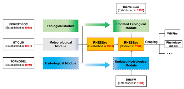
Figure 1. The development history of RHESSys.
RHESSys describes a basin as an object containment hierarchy of Basin, Zone, Hillslope, Patch, and Canopy strata, which allows different hydrological and ecological processes to be modeled at different scales[20] (Figure 2). The patch represents the smallest unit that has similar soil moisture and land cover. The soil representation is a relatively simple bilayer generalization, i.e., unsaturated and saturated layers. Vertical soil moisture processing and soil biogeochemical cycles are modeled at this level considering snowpack and litter stores. Patches can be derived by multiple layers of land use, soil moisture distribution, or topographic map. Canopy strata describes the vertical process above the ground at the same resolution and partition with the patch, which mainly refers to the physiological processes for plants such as respiration and photosynthesis. In short, the subsurface process is modeled in the patch while the aboveground process is modeled in the canopy strata. The hillslope defines horizontal water movement and redistribution between patches to produce streamflow in a sub-catchment that drains into a stream reach. The hillslope is often derived by GIS-based terrain-partitioning algorithms. The zone defines a region that is usually partitioned by the distribution of climate stations or elevation bands. The zone contains meteorological variables and uses extrapolation methods to characterize spatial variation in these variables. The basin defines a spatial boundary for a catchment, which generally refers to the entire watershed simulated by the model. The basin typically aggregates the net flux of water, carbon, and nitrogen across the whole study area[2][20].
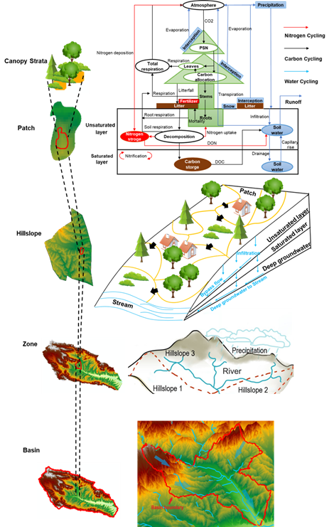
Figure 2. The hierarchical structure of RHESSys (Edited based on [15,16]).
Table 1 illustrates structures, key processes, and applications for various ecohydrological models. It is prominent that RHESSys has a hierarchical structure (Figure 2) to better reflect the multi-scale characteristics of ecohydrological processes in a watershed while other ecohydrological models have ‘basin-grid’ and 'basin-subbasin-grid' structures. For instance, Gorelick et al.[16] found that RHESSys can handle mixed and heterogeneous land cover at a fine spatial resolution and is suitable for more detailed ecohydrological modeling in small catchments. However, SWAT (Soil and Water Assessment Tool) is spatially lumped at the subbasin level and applies to model large basins with spatially well-segregated landscapes. Moreover, RHESSys realized the bidirectional coupling of the eco-hydrological processes, depicting not only the effects of soil water processes on the plant physiological processes, but also the impacts of vegetation growth on hydrological processes. In contrast, most earlier ecohydrological models (i.e., SWAT and TOPOG_IRM) simplified the complicated vegetation–water interactions. Morán–Tejeda et al.[17] compared the performance of RHESSys and SWAT with the same input and application areas. The results suggested that RHESSys was more sensitive to land cover and vegetation change while SWAT produced larger changes under climate change. The major underlying cause was that SWAT uses empirical functions of potential evapotranspiration to calculate evapotranspiration, but RHESSys estimates evapotranspiration in a more process-based way, as a complex representation of canopy transpiration controlled by rooting depth, stomatal conductance, etc. Therefore, RHESSys has the advantage for watershed simulations that focus on land cover or vegetation–water interactions. In addition, RHESSy has a flexible structure to further dynamically couple with other models such as phenology, fire, and land-use models, leading to a wider range of applications to support the water resources management under assorted conditions[2][3][4][5].
Table 1. Characteristics of RHESSys and ecohydrological models used in literature.
|
Model |
Structure |
Key Processes Representing Eco-Hydrological Interactions |
Applications |
References |
|
RHESSys |
Basin-Zone-Hillslope-Patch-Canopy strata |
Carbon and nitrogen cycling of soil and vegetation, Plant physiological process, Evapotranspiration, Lateral flow, Slope confluence |
Urbanization, Water quality, Climate change, Disturbance, Water resource management, Land management, Biogeochemical cycle |
[2] |
|
TOPOG_IRM |
Basin-subbasin |
Carbon cycling of vegetation, Plant physiological process, Evapotranspiration, Lateral flow, Slope confluence |
Climate change, Disturbance, Water resource management, Land management, Biogeochemical cycle |
[18] |
|
SWAT (Soil and Water Assessment Tool) |
Basin-subbasin-Hydrological response units |
Evapotranspiration, Lateral flow |
Urbanization, Water quality, Climate change, Water resource management, Land management |
[19] |
|
BEPS-TerrainLab (Boreal Ecosystem Productivity Simulator-TerrainLab) |
Basin-grid |
Carbon and nitrogen cycling of soil and vegetation, Plant physiological process, Evapotranspiration, Lateral flow, Slope confluence |
Water resource management, Biogeochemical cycle |
[21] |
|
tRIBS-VEGGIE (TIN-based Real-time Integrated Basin Simulator-Vegetation Generator for Interactive Evolution) |
Basin-tin |
Carbon cycling of soil and vegetation, Plant physiological process, Evapotranspiration, Lateral flow Slope confluence |
Disturbance, Water resource management, Biogeochemical cycle |
[22] |
3. Future Perspectives of RHESSys
3.1. Key Challenges
The application of RHESSys has been hindered by the complexity and availability of parameters, and the requirement of detailed data. As a physical process-based model, RHESSys simulates the ecohydrological processes at the expense of involving substantial parameters and data support, which impedes the application of RHESSys and induces more uncertainties[23][24]. Son et al. [25] found difficulties in determining snow and soil parameters for dissolved carbon simulations, which may cause a bias in model outputs. Martin et al.[6] pointed out the lack of detailed rainfall intensity and urban drainage data, which may induce underestimating the peak streamflow. Although empirical parameters have been provided for some biomes[2][26], the model users often need to modify the ecological parameters to cope with localized vegetations[27].
The calibration approaches incorporated into RHESSys also need to be improved. Currently, RHESSys employs the Monte Carlo method that optimizes the parameters by randomly sampling paired parameter groups and picking out a group with the best performance. This approach usually requires tremendous computational resources. Furthermore, the automatic optimization is available only for soil-related and water quality-related parameters in RHESSys. Although Reyes et al.[28] applied a Latin super-square sampling method to optimize carbon-allocation parameters, most studies have calibrated vegetation-related parameters manually. Thus, the automated and more systematic and efficient calibration methods for vegetation-related parameters are needed[29][30]
As RHESSys has initially been designed for small-scale basins[2][9], application for a large-scale basin is a challenge. Since large watersheds have strong spatial heterogeneity in the ecosystem and usually include data-sparse areas, it is often challenging to obtain sufficient data and parameters to be used for RHESSys, resulting in high uncertainties. Besides, the applications for a large-scale basin require high-performance hardware to perform huge computational tasks. Therefore, the current applications often simplify vegetation types and degrade the spatial resolution to reduce the complexity of modeling for large basins[9][26].
RHESSys has been applied for a variety of fields such as climate change and land management. However, the current studies have mainly focused on natural systems in watersheds while few studies have taken into account socio-economic systems. Few studies have paid attention to linking the outputs of the carbon, nitrogen, and water simulations from RHESSys to the regional water supply–demand balance, ecosystem services, or human well-being. RHESSys has a lot of potentials to quantify ecosystem services more accurately and to be a useful tool for studies on watershed sustainability. However, there are few relevant studies in the literature[25][31].
3.2. Future Directions
RHESSys needs to enhance the abilities of data collection for improving the simulation capabilities of regional water resources and land management [79]. A single data source may often result in the overfitting phenomenon of parameters, leading to unreliable simulations and predictions [73]. In this sense, multi-source data composition and data assimilation methods can be an alternative to be employed into RHESSys. For instance, Sakas et al.[32] effectively improved the calibration efficiency by incorporating multi-sources data such as remote-sensing products, ground observations, and field measurements. Hanan et al. [34] also incorporated remote sensing data to set a goal state in the spin-up process, which enhanced the reliability and accuracy of model outputs. Moreover, a more comprehensive parameter library can be built from various applications in parameter localization and advanced remote-sensing technologies.
A number of calibration methods have been developed and applied for hydrologic models such as simulated annealing (SA)[33], genetic algorithm (GA)[34] and shuffled complex evolution method (SCE-UA)[35]. Therefore, RHESSys needs to incorporate the most suitable calibration methods in the future to improve calibration efficiency.
In addition, RHESSys is necessary to be further adapted to large-scale basins. Over the last years, ecohydrological simulations at a large-scale have received attention more and more as climate and land-use change have intertwined with ecohydrology[36]. As the current version of RHESSys may not be suitable for simulating a large-scale basin, the model structure and some mechanisms need to be modified to adapt to a large-scale basin. Moreover, a parallel computation module is also very useful to reduce computational burdens.
As human activities have intensively increased in watersheds, previous RHESSys-related studies have investigated the impacts of human activities on the ecohydrological process, such as urban planning, agricultural irrigation, soil and water conservation, and reservoir construction[8][9][37]. It is necessary to project the impacts of human activities on sustainability in a watershed. Consequently, RHESSys provides a useful tool to quantify watershed ecosystem services and to assess regional sustainability, resulting in promoting sustainable development for watersheds.
References
- Band, L.E.; Patterson, P.; Nemani, R.; Running, S.W. Forest Ecosystem Processes at the Watershed Scale-Incorporating Hillslope Hydrology. Agric. For. Meteorol. 1993, 63, 93–126.
- Tague, C.L.; Band, L.E. RHESSys: Regional Hydro-Ecologic Simulation System-An Object-Oriented Approach to Spatially Distributed Modeling of Carbon, Water, and Nutrient Cycling. Earth Interact. 2004, 8, 1–42.
- Bart, R.R.; Kennedy, M.C.; Tague, C.L.; McKenzie, D. Integrating fire effects on vegetation carbon cycling within an ecohydrologic model. Ecol. Model. 2020, 416, 16.
- Kennedy, M.C.; McKenzie, D.; Tague, C.; Dugger, A.L. Balancing uncertainty and complexity to incorporate fire spread in an eco-hydrological model. Int. J. Wildland Fire 2017, 26, 706–718.
- Kim, J.H.; Hwang, T.; Yang, Y.; Schaaf, C.L.; Boose, E.; Munger, J.W. Warming-Induced Earlier Greenup Leads to Reduced Stream Discharge in a Temperate Mixed Forest Catchment. J. Geophys. Res. Biogeosci. 2018, 123, 1960–1975.
- Martin, K.L.; Hwang, T.; Vose, J.M.; Coulston, J.W.; Wear, D.N.; Miles, B.; Band, L.E. Watershed impacts of climate and land use changes depend on magnitude and land use context. Ecohydrology 2017, 10, e1870.
- Mohammed, I.N.; Tarboton, D.G. Simulated watershed responses to land cover changes using the Regional Hydro-Ecological Simulation System. Hydrol. Process. 2014, 28, 4511–4528.
- Zabalza-Martínez, J.; Vicente-Serrano, S.; López-Moreno, J.; Borràs Calvo, G.; Savé, R.; Pascual, D.; Pla, E.; Morán-Tejeda, E.; Domínguez-Castro, F.; Tague, C.L. The Influence of Climate and Land-Cover Scenarios on Dam Management Strategies in a High Water Pressure Catchment in Northeast Spain. Water 2018, 10, 1668.
- Peng, H.; Jia, Y.W.; Tague, C.; Slaughter, P. An Eco-Hydrological Model-Based Assessment of the Impacts of Soil and Water Conservation Management in the Jinghe River Basin, China. Water 2015, 7, 6301–6320.
- Running, S.W.; Nemani, R.R.; Hungerford, R.D. Extrapolation of Synoptic Meteorological Data in Mountainous Terrain and Its Use for Simulating Forest Evapotranspiration and Photosynthesis. Can. J. For. Res. Rev. Can. Rech. For. 1987, 17, 472–483.
- Running, S.W.; Coughlan, J.C. A general model of forest ecosystem processes for regional applications I. Hydrologic balance, canopy gas exchange and primary production processes. Ecol. Model. 1988, 42, 125–154.
- Beven, K.J.; Kirkby, M.J. A physically based, variable contributing area model of basin hydrology/Un modèle à base physique de zone d'appel variable de l'hydrologie du bassin versant. Hydrol. Sci. Bull. 1979, 24, 43–69.
- Parton, W.J.; Mosier, A.R.; Ojima, D.S.; Valentine, D.W.; Schimel, D.S.; Weier, K.; Kulmala, A.E. Generalized model for N2and N2O production from nitrification and denitrification. Glob. Biogeochem. Cycles 1996, 10, 401–412.
- About RHESSys. Available online: http://fiesta.bren.ucsb.edu/~rhessys/about/about.html#intro (accessed on 14 Novmber 2019).
- Colorado State Geography Presentation. Available online: http://fiesta.bren.ucsb.edu/~rhessys/setup/downloads/files/colorado_geog.pdf (accessed on 14 Novmber 2019).
- Gorelick, D.E.; Lin, L.; Zeff, H.B.; Kim, Y.; Vose, J.M.; Coulston, J.W.; Wear, D.N.; Band, L.E.; Reed, P.M.; Characklis, G.W. Accounting for Adaptive Water Supply Management When Quantifying Climate and Land Cover Change Vulnerability. Water Resour. Res. 2020, 56, 27.
- Morán-Tejeda, E.; Zabalza, J.; Rahman, K.; Gago-Silva, A.; López-Moreno, J.I.; Vicente-Serrano, S.; Lehmann, A.; Tague, C.L.; Beniston, M. Hydrological impacts of climate and land-use changes in a mountain watershed: Uncertainty estimation based on model comparison. Ecohydrology 2015, 8, 1396–1416.
- Watson, F.G.R.; Vertessy, R.A.; Grayson, R.B. Large-scale modelling of forest hydrological processes and their long-term effect on water yield. Hydrol. Process. 1999, 13, 689–700.
- Arnold, J.G.; Srinivasan, R.; Muttiah, R.S.; Williams, J.R. Large Area Hydrologic Modeling and Assessment Part I: Model Development. J. Am. Water Resour. Assoc. 1998, 34, 73–89.
- Band, L.E.; Tague, C.L.; Groffman, P.; Belt, K. Forest ecosystem processes at the watershed scale: Hydrological and ecological controls of nitrogen export. Hydrol. Process. 2001, 15, 2013–2028.
- Govind, A.; Chen, J.M.; Margolis, H.; Ju, W.M.; Sonnentag, O.; Giasson, M.A. A spatially explicit hydro-ecological modeling framework (BEPS-TerrainLab V2.0): Model description and test in a boreal ecosystem in Eastern North America. J. Hydrol. 2009, 367, 200–216.
- Ivanov, V.Y.; Bras, R.L.; Vivoni, E.R. Vegetation-hydrology dynamics in complex terrain of semiarid areas: 1. A mechanistic approach to modeling dynamic feedbacks. Water Resour. Res. 2008, 44, 34.
- Shields, C.; Tague, C. Ecohydrology in semiarid urban ecosystems: Modeling the relationship between connected impervious area and ecosystem productivity. Water Resour. Res. 2015, 51, 302–319.
- Shields, C.A.; Tague, C.L. Assessing the Role of Parameter and Input Uncertainty in Ecohydrologic Modeling: Implications for a Semi-arid and Urbanizing Coastal California Catchment. Ecosystems 2012, 15, 775–791.
- Son, K.; Tague, C. Hydrologic responses to climate warming for a snow-dominated watershed and a transient snow watershed in the California Sierra. Ecohydrology 2019, 12, e2053.
- White, M.; Thornton, P.; Running, S.; Nemani, R.R. Parameterization and sensitivity analysis of the BIOME–BGC terrestrial ecosystem model: Net primary production controls. Earth Interact. 2000, 4, 1–85.
- Hwang, T.; Martin, K.L.; Vose, J.M.; Wear, D.; Miles, B.; Kim, Y.; Band, L.E. Nonstationary Hydrologic Behavior in Forested Watersheds Is Mediated by Climate-Induced Changes in Growing Season Length and Subsequent Vegetation Growth. Water Resour. Res. 2018, 54, 5359–5375.
- Reyes, J.J.; Tague, C.L.; Evans, R.D.; Adam, J.C. Assessing the Impact of Parameter Uncertainty on Modeling Grass Biomass Using a Hybrid Carbon Allocation Strategy. J. Adv. Modeling Earth Syst. 2017, 9, 2968–2992.
- Hwang, T.; Kangw, S.; Kim, J.; Kim, Y.; Lee, D.; Band, L. Evaluating drought effect on MODIS Gross Primary Production (GPP) with an eco-hydrological model in the mountainous forest, East Asia. Glob. Chang. Biol. 2008, 14, 1037–1056.
- Zierl, B.; Bugmann, H.; Tague, C.L. Water and carbon fluxes of European ecosystems: An evaluation of the ecohydrological model RHESSys. Hydrol. Process. 2007, 21, 3328–3339.
- Leonard, L.; Miles, B.; Heidari, B.; Lin, L.; Castronova, A.M.; Minsker, B.; Lee, J.; Scaife, C.; Band, L.E. Development of a participatory Green Infrastructure design, visualization and evaluation system in a cloud supported jupyter notebook computing environment. Environ. Model. Softw. 2019, 111, 121–133.
- Saksa, P.C.; Conklin, M.H.; Battles, J.J.; Tague, C.L.; Bales, R.C. Forest thinning impacts on the water balance of Sierra Nevada mixed-conifer headwater basins. Water Resour. Res. 2017, 53, 5364–5381.
- Kirkpatrick, S.; Gelatt, C.D., Jr.; Vecchi, M.P. Optimization by simulated annealing. Science 1983, 220, 671–680.
- Holland, J.H. Adapation in Natural and Artificial Systems: An introductory Analysis with Applications to Biology, Control, and Artificial Intelligence; University of Michigan Press: Ann Arbor, MI, USA, 1975.
- Duan, Q.Y.; Sorooshian, S.; Gupta, V. Effective and Efficient Global Optimization for Conceptual Rainfall-Runoff Models. Water Resour. Res. 1992, 28, 1015–1031.
- Fatichi, S.; Pappas, C.; Ivanov, V.Y. Modeling plant-water interactions: An ecohydrological overview from the cell to the global scale. Wiley Interdiscip. Rev. Water 2016, 3, 327–368.
- Bell, C.D.; Tague, C.L.; McMillan, S.K. Modeling Runoff and Nitrogen Loads From a Watershed at Different Levels of Impervious Surface Coverage and Connectivity to Storm Water Control Measures. Water Resour. Res. 2019, 55, 2690–2707.


