 +1 credit
| Version | Summary | Created by | Modification | Content Size | Created at | Operation |
|---|---|---|---|---|---|---|
| 1 | Noelia Guaita Garcia | + 2595 word(s) | 2595 | 2020-09-15 12:02:51 | | | |
| 2 | Rita Xu | Meta information modification | 2595 | 2020-09-16 12:10:54 | | | | |
| 3 | Rita Xu | -745 word(s) | 1850 | 2020-09-16 12:15:32 | | |
Video Upload Options
Scenario analysis is a useful tool to facilitate discussions about the main trends of future change and to promote the understanding of global environmental changes implications on relevant aspects of sustainability.
1. Introduction
In recent decades, changes in land use and climate have had major impacts on the environment at local, regional and global scales [1][2][3][4][5]. The high rate of land use change and climate change are now one of the most important environmental problems on regional to global scales [2][6][7][8]. Both processes operate simultaneously, with feedbacks at varying spatial and temporal scales.
Given this significant and accelerated process of global change, the need arises to analyze and understand the interactions between human activities and natural resources [2], which leads to the definition of social-ecological systems as a unit of analysis and management. Berkes and Folke (1998) [9] point out that social systems and natural systems are linked at a multi-scale level and that the exclusive delimitation of an ecosystem or the resulting social system is arbitrary and artificial. Janssen and Ostrom (2006) [10] define social-ecological systems as complex adaptive systems in which social and bio-geophysical agents are interacting through multiple spatial-temporal scales. This approach from social-ecological systems will allow to build alternative ways of interaction between society and ecosystems towards sustainability.
Case studies of these types of systems, such as watersheds, are key to understand their functionality and to address the specific problems that threaten them, such as land use change and climate change. This requires a thorough understanding of the causes that determine land use and climate change and the use of simulation tools capable of taking into account the interactions among key factors of socioeconomic and environmental subsystems. This will allow us to explore the consequences in the medium and long-term in aspects relevant to sustainability such as water resources, biodiversity or nature conservation policies. However, the effects of land use change on water resources may not be as obvious, depending on the spatial scale of analysis.
In recent years, advances in research and understanding have led to increased attention to the importance of future scenarios of land use change [11][12][13], with simulation models [14][15][16][17] helping in the analysis of environmental responses.
Scenarios of land use change make possible to explore potential futures and their environmental consequences, as well as potential solutions to environmental problems and thus support decision-making [18]. A scenario is a creative, visionary tool that can support planning for a desired future as well as the preparation for possible undesirable events [19]. Scenarios are best developed not by researchers alone but with stakeholder participation. However, there are many successful and high-profile scenarios that have been developed with little participation from stakeholders [20][21]. Participatory approaches offer a chance to discuss, negotiate, and reach agreement [22][23].
The involvement of stakeholders in designing land use scenarios helps to identify acceptable land use alternatives by reflecting local preferences in land use decisions [24]. It facilitates the understanding of the multifaceted nature of land use issues from the perspective of stakeholders who are directly affected by land use decisions, but with usually limited participation in science and policy discourses [25]. However, development of land use change scenarios which are spatially explicit and detailed remains a complex challenge.
2. Results
Of the 294 articles that were found to include scenario analysis of land use change, nearly half (49%) analyzed the changes at watershed scale. These articles focusing on watersheds are relatively recent, especially when considering the joint study of land use change with climate change and/or analysis of the synergistic effect of both processes (Figure 1). In the last decade of the analyzed period, 79% of the articles on land use change scenarios in watersheds were published. More than half of the publications also discussed the climate change (72%). The synergistic effect of both processes (80%) were published in the last six years (2014–2019). The data indicate that recent advances in research and/or changing research priorities may provide more complete knowledge about the likely trajectories of land use change under different scenarios and their synergistic effect with climate change at a watershed scale.
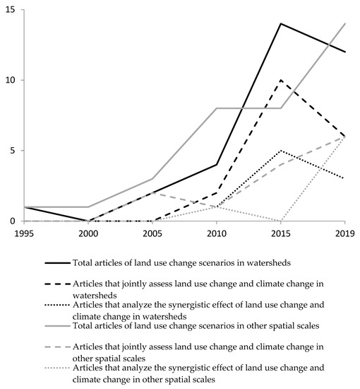
Figure 1. Number of publications in the analysis of land use change scenarios. 1995–2019.
Only 47% of these articles of land use change at the watershed scale also analyzed the process of climate change. In this group, most cases applied regionalized climate change scenarios (68%) compared to global scenarios (32%), possibly due to the increasing availability of regionalized scenarios. Of articles at the watershed scale that also address climate change, more than half (52%) analyzed the synergistic effect between the two processes of global change. Moreover, the evolution over time of these group of articles is rising, although there is a small recession in the last two years (2018 and 2019) (Figure 1).
As for the methodology applied to analyze scenarios of land use changes in watersheds, dynamic spatially distributed models were used more often than spatial statistical models (Table 1). Among the dynamic spatially distributed models the most used were the hydrological models (83%). Specifically, the SWAT model was used in 28% of the reviewed articles. The consideration or lack thereof of climate change did not significantly alter the overall distribution of applied methodological approaches (Table 1).
Table 1. Models classification applied in the analysis of land use change scenarios in watersheds.
| Models Classification | Number of Total Articles in Watersheds | Number of Articles of Land Use Change and Climate Change Jointly Analyzed in Watersheds | Number of Articles of Synergistic Effects of Land Use Change and Climate Change in Watersheds |
|---|---|---|---|
| Non-spatial statistical model | 4 | 0 | 0 |
| Spatial statistical model (e.g., GIS) | 14 | 5 | 5 |
| Aggregated dynamic model | 0 | 0 | 0 |
| Dynamic spatially distributed model | 119 | 59 | 30 |
| Other methodologies | 6 | 3 | 0 |
| Total | 143 | 67 | 35 |
Moreover, in order to know the methodological approach of the models (sectoral or integrated approach), we identified what kind of land use change effects were considered in the reviewed papers, including effects on hydrological dynamics, nutrient dynamics and other different potential environmental effects that may affect the sustainability of the watershed socio-ecological system. Most papers evaluated the hydrological dynamics effects (75%), and there was less frequent analysis of the effects on the dynamics of nutrients (26%) and other environmental attributes (28%), mainly the loss of biodiversity and ecosystem services. Again, the consideration or lack thereof of climate change did not substantially alter the type of analyzed effects.
Most of these publications (86%) evaluated these impacts in the watershed with a sectoral (hydro-ecological discipline) approach. The percentage of articles analyzing the hydrological dynamics effects without considering other possible effects in the watershed were 67%, although the analysis of the effects on the dynamics of the nutrients in the watershed was accompanied by the study of the hydrological dynamics effects in most cases (65%), especially when taking into account the synergistic effect of climate change (91%). Moreover, the study of other environmental effects was accompanied by the study of the hydrological dynamic effects in the 35% of the articles. The analysis of hydrological and nutrient dynamics effects along with other different environmental effects in the watershed was studied in just 2% of the publications, where the watershed was analyzed as a social-ecological system.
These results indicated that there were few integrated approaches, and the analyses were focused primarily on the hydrological dynamics effects of the watershed, versus an integrated and more interdisciplinary approach.
The articles that have analyzed land use changes scenarios in other spatial scales were placed together on a percentage slightly higher to that of watershed (51% of the 294 reviewed publications). More than 50% (specifically, 53%) of these articles were also published in the period 2014–2019 (Figure 1).
Notably, only 28% of these articles analyzed the process of climate change, a much lower percentage than in the case of watersheds (47%). Moreover, only 48% of these cases used regionalized climate change scenarios. Just as in watersheds, 67% of the publications that took into account both processes of global change, were published in the last six years, from 2014 to 2019 (Figure 1). The study of the synergistic effect of land use change and climate change was discussed only in seventeen studies (39%) and 81% of these studies were published in the last four years (2016–2019) (Figure 1).
In relation to the methodology used in the analysis of scenarios in other spatial scales, it is noteworthy that although the dynamic spatially-distributed models remained the most common method, their use was not as major as in the case of the analysis of land use change scenarios in watersheds (Table 1). The spatial statistical models rose to 59% in the articles analyzing the synergistic effects of land use change and climate change (Table 2).
Table 2. Models classification applied in the analysis of land use change scenarios in other spatial scales to watershed.
| Models Classification | Number of Total Articles in Other Spatial Scales to Watershed | Number of Articles of Land Use Change and Climate Change Jointly Analyzed in Other Spatial Scales to Watershed | Number of Articles of Synergistic Effects of Land Use Change and Climate Change in Other Spatial Scales to Watershed |
|---|---|---|---|
| Non-spatial statistical model | 26 | 4 | 0 |
| Spatial statistical model (e.g., GIS) | 26 | 11 | 10 |
| Aggregated dynamic model | 1 | 0 | 0 |
| Dynamic spatially distributed model | 72 | 24 | 7 |
| Other methodologies | 26 | 4 | 0 |
| Total | 151 | 43 | 17 |
Unlike the analysis of land use change scenarios in watersheds, most of these publications in other spatial scales assessed other environmental effects (87%) compared to the effects of hydrological dynamics (9%) and nutrients (3%). The consideration or lack thereof of climate change did not substantially alter the type of effects analyzed. The approach for the analysis of scenarios in other spatial scales was totally sectorial and cases studies were not analyzed within the social-ecological framework. Overall, 95% of articles studying other environmental effects on scenario analysis did not take into account the effects on the hydrological dynamics and nutrients.
The participation of stakeholders in the process of building land use change scenarios was only collected in twelve articles (Table 3) and 50% of these articles have been published recently—in the last four years (2016–2019). Most of the articles (95%) developed land use scenarios with researcher-driven approaches [4][28][29][30][31][32][33], where the experts drove scenario development with an objective of providing rigorous descriptions of plausible futures, including details that are well supported by available science.
Table 3. Articles with a participatory approach in the land use change scenarios development.
| References | Spatial Scale | Land Use Change and Climate Change Jointly Analyzed | Synergistic Effect of Land Use Change and Climate Change | Methodology to Study LUC | Effects on Hydrological Dynamic | Effects on Nutrients Dynamic | Other Environmental Effects |
|---|---|---|---|---|---|---|---|
| Mancosu, E. et al. 2014 [34] | Catchment | YES | NO | Dynamic spatially distributed models | YES | NO | NO |
| Harmácková, Z.V. and Vacka, D. 2015 [18] | Basin | NO | NO | Dynamic spatially distributed models | NO | YES | YES |
| Ronfort, C. et al. 2011 [35] | Watershed | NO | NO | Dynamic spatially distributed models | YES | NO | NO |
| Rickebusch, S. et al. 2011 [36] | Regional | NO | NO | Spatial statistical model | NO | NO | YES |
| Castella, J.C., Verburg, P.H. 2007 [37] | Local | NO | NO | Dynamic spatially distributed models | NO | NO | YES |
| van Noordwijk, M. et al. 2001 [38] | Local | NO | NO | Dynamic spatially distributed models | NO | NO | YES |
| Kim, Y.S. et al. 2018 [39] | Local | NO | NO | Dynamic spatially distributed models | YES | NO | YES |
| Lippe, M. et al. 2017 [40] | Local | NO | NO | Dynamic spatially distributed models | NO | NO | YES |
| Sherrouse, B.C. et al. 2017 [41] | Local | NO | NO | Spatial statistical model | NO | NO | YES |
| Benini, L. et al. 2016 [42] | Basin | YES | YES | Dynamic spatially distributed models | YES | NO | NO |
| Trisurat, Y. et al. 2016 [43] | Watershed | YES | NO | Dynamic spatially distributed models | YES | NO | NO |
| Min, F. et al. 2016 [44] | Watershed | YES | NO | Dynamic spatially distributed models | YES | YES | NO |
References
- Whitaker, J.; Ludley, K.E.; Rowe, R.; Taylor, G.; Howard, D.C. Sources of variability in greenhouse gas and energy balances for biofuel production: A systematic review. GCB Bioenergy 2010, 2, 99–112.
- Hurtt, G.C.; Chini, L.P.; Frolking, S.; Betts, R.A.; Feddema, J.; Fischer, G.; Fisk, J.P.; Hibbard, K.; Houghton, R.A.; Janetos, A.; et al. Harmonization of land-use scenarios for the period 1500–2100: 600 years of global gridded annual land-use transitions, wood harvest, and resulting secondary lands. Clim. Chang. 2011, 109, 117–161.
- Mehdi, B.; Lehner, B.; Gombault, C.; Michaud, A.; Beaudin, I.; Sottile, M.F.; Blondlot, A. Simulated impacts of climate change and agricultural land use change on surface water quality with and without adaptation management strategies. Agric. Ecosyst. Environ. 2015, 213, 47–60.
- Serpa, D.; Nunes, J.P.; Santos, J.; Sampaio, E.; Jacinto, R.; Veiga, S.; Lima, J.C.; Moreira, M.; Corte-Real, J.; Keizer, J.J.; et al. Impacts of climate and land use changes on the hydrological and erosion processes of two contrasting Mediterranean catchments. Sci. Total Environ. 2015, 538, 64–77.
- Hamaoui-Laguel, L.; Vautard, R.; Liu, L.; Solmon, F.; Viovy, N.; Khvorostyanov, D.; Essl, F.; Chuine, I.; Colette, A.; Semenov, M.A.; et al. Effects of climate change and seed dispersal on airborne ragweed pollen loads in Europe. Nat. Clim. Chang. 2015, 5, 766–771.
- Pielke, L.A. Land use and climate change. Science 2005, 310, 1625–1626.
- Boyd, E.; Corbera, E.; Estrada, M. UNFCCC negotiations (pre-Kyoto to COP-9): What the process says about the politics of CDM-sinks. Int. Environ. Agreem. 2008, 8, 95–112.
- McCarthy, M.P.; Best, M.J.; Betts, R.A. Climate change in cities due global warming and urban effects. Geophys. Res. Lett. 2010, 9, L09705.
- Ojima, D.S.; Galvin, K.A.; Turner, B.L., II. The global impact of land use change. BioScience 1994, 5, 300–304.
- Berkes, F.; Folke, C. (Eds.) Linking Sociological and Ecological Systems: Management Practices and Social Mechanisms for Building Resilience; Cambridge University Press: New York, NY, USA, 1998.
- Janssen, M.A.; Ostrom, E. Governing social-ecological systems. In Handbook of Computational Economics II: Agent-Based Computational Economics; Tesfatsion, L., Judd, K.L., Eds.; Elsevier Publisher: Amsterdam, The Netherlands, 2006; pp. 1465–1509.
- NRC. Grand Challenge in Environmental Sciences; Committee on Grand Challenges in Environmental Sciences; National Research Council, National Academy Press: Washington, DC, USA, 2001; 106p.
- Verburg, P.H.; Schulp, C.J.E.; Witte, N.; Veldkamp, A. Downscaling of land use change scenarios to assess the dynamics of European landscapes. Agric. Ecosyst. Environ. 2006, 114, 39–56.
- Hopkins, L.D.; Zapata, M.A. Engaging the Future; Lincoln Land Institute of Land Policy: Cambridge, MA, USA, 2007; pp. 1–17.
- Verburg, P.H.; Soepboer, W.; Veldkamp, A.; Mimpiada, R.; Espaldon, V.; Mastura, S.S.A. Modeling the Spatial Dynamics of Regional Land Use: The CLUE-S Model. Environ. Manag. 2002, 30, 391.
- Paegelow, M.; Camacho, M.; Menor, J. Cadenas de Markov, evaluación multicriterio y evaluación multiobjetivo para la modelización prospectiva del paisaje. GeoFocus 2003, 3, 22–44.
- Bossa, A.Y.; Diekkrüger, B.; Agbossou, E.K. Scenario-Based Impacts of Land Use and Climate Change on Land and Water Degradation from the Meso to Regional Scale. Water 2014, 6, 3152–3181.
- Harmácková, Z.V.; Vackár, D. Modelling regulating ecosystem services trade-offs across landscape scenarios in Trebonsko Wetlands Biosphere Reserve, Czech Republic. Ecol. Model. 2015, 295, 207–215.
- Kriegler, E.; O’Neill, B.C.; Hallegatte, S.; Kram, T.; Lempert, R.; Moss, R.; Wilbanks, T. The need for and use of socio-economic scenarios for climate change analysis: A new approach based on shared socio-economic pathways. Glob. Environ. Chang. 2012, 22, 807–822.
- Wollenberg, E.; Edmunds, D.; Buck, L. Using scenarios to make decisions about the future: Anticipatory learning for the adaptive co-management of community forests. Landsc. Urban Plan. 2000, 47, 65–77.
- Intergovernmental Panel on Climate Change. IPCC Special Report: Emissions Scenarios; IPCC: The Hague, The Netherlands, 2000.
- Millennium Ecosystem Assessment. Ecosystems and Human Well-Being; Synthesis Island Press: Washington, DC, USA, 2005.
- Patel, M.; Kok, K.; Rothman, D.S. Participatory scenario construction in land use analysis: An insight into the experiences created by stakeholder involvement in the Northern Mediterranean. Land Use Policy 2007, 3, 546–561.
- Hoyer, R.W.; Chang, H. Development of Future Land Cover Change Scenarios in the Metropolitan Fringe, Oregon, U.S., with Stakeholder Involvement. Land 2014, 1, 322–341.
- Koo, H.; Kleemann, J.; Fürst, C. Land Use Scenario Modeling Based on Local Knowledge for the Provision of Ecosystem Services in Northern Ghana. Land 2018, 2, 59.
- Reed, M.S.; Dougill, A.J.; Taylor, M.J. Integrating local and scientific knowledge for adaptation to land degradation: Kalahari rangeland management options. Land Degrad. Dev. 2007, 18, 249–268.
- Wilkinson, A.; Eidinow, E. Evolving practices in environmental scenarios: A new scenario typology. Environ. Res. Lett. 2008, 3, 4.
- Van Notten, P. Scenario Development: A Typology of Approaches. In Think Scenarios, Rethink Education; OECD: Paris, France, 2006.
- Tong, S.T.Y.; Sun, Y.; Ranatunga, T.; He, J.; Yang, Y.J. Predicting plausible impacts of sets of climate and land use change scenarios on water resources. Appl. Geogr. 2011, 32, 477–489.
- Fernandez, M.R.; Segurado, P.; Jauch, E. Riparian responses to extreme climate and land-use change scenarios. Sci. Total Environ. 2016, 569, 145–158.
- Chaudhary, A.; Mooers, A.O. Terrestrial Vertebrate Biodiversity Loss under Future Global Land Use Change Scenarios. Sustainability 2018, 10, 2764.
- Di Febbraro, M.; Russo, D. Integrating climate and land-use change scenarios in modelling the future spread of invasive squirrels in Italy. Divers. Distrib. 2019, 25, 644–659.
- Fonseca, M.G.; Alves, L.M.; Dutra Aguiar, A.P. Effects of climate and land use change scenarios on fire probability during the 21st century in the Brazilian Amazon. Global Chang. Biol. 2019, 25, 2931–2946.
- Mancosu, E.; Gago-Silva, A.; Barbosa, A.; de Bono, A.; Ivanov, E.; Lehmann, A.; Fons, J. Future land-use change scenarios for the Black Sea catchment. Environ. Sci. Policy 2014, 46, 26–36.
- Ronfort, C.; Souchère, V.; Martin, P.; Sebillotte, C.; Castellazzi, M.S.; Barbottin, A.; Meynard, J.M.; Laignel, B. Methodology for land use change scenario assessment for runoff impacts: A case study in a north-western European Loess belt region (Pays de Caux, France). Catena 2011, 86, 36–48.
- Rickebusch, S.; Metzger, M.J.; Xu, G.; Vogiatzakis, I.N.; Potts, S.G.; Stirpe, M.T.; Rounsevell, M. A qualitative method for the spatial and thematic downscaling of land-use change scenarios. Environ. Sci. Policy 2011, 14, 268–278.
- Castella, J.C.; Verburg, P.H. Combination of process-oriented and pattern-oriented models of land-use change in a mountain area of Vietnam. Ecol. Model. 2007, 202, 410–420.
- van Noordwijk, M.; Tomich, T.P.; Verbist, B. Negotiation support models for integrated natural resource management in tropical forest margins. Conserv. Ecol. 2001, 5, 21.
- Kim, Y.S.; Latifah, S.; Afifi, M. Managing forests for global and local ecosystem services: A case study of carbon, water and livelihoods from eastern Indonesia. Ecosyst. Serv. 2018, 31, 53–168.
- Lippe, M.; Hilger, T.; Sudchalee, S. Simulating Stakeholder-Based Land-Use Change Scenarios and Their Implication on Above-Ground Carbon and Environmental Management in Northern Thailand. Land 2017, 6, 85.
- Sherrouse, B.C.; Semmens, D.J.; Ancona, Z.H. Analyzing land-use change scenarios for trade-offs among cultural ecosystem services in the Southern Rocky Mountains. Ecosyst. Serv. 2017, 26, 431–444.
- Benini, L.; Antonellini, M.; Laghi, M. Assessment of Water Resources Availability and Groundwater Salinization in Future Climate and Land use Change Scenarios: A Case Study from a Coastal Drainage Basin in Italy. Water Resour. Manag. 2016, 30, 731–745.
- Trisurat, Y.; Eawpanich, P.; Kalliola, R. Integrating land use and climate change scenarios and models into assessment of forested watershed services in Southern Thailand. Environ. Res. 2016, 147, 611–620.
- Min, F.; Hideaki, S.; Qing, W. Optimal conservation planning of multiple hydrological ecosystem services under land use and climate changes in Teshio river watershed, northernmost of Japan. Ecol. Indic. 2016, 62, 1–13.


