Economic and social development of urban and rural areas continues in parallel with the increase of the human population, especially in developing countries, which leads to sustained expansion of impervious surface areas, particularly paved surfaces. The conversion of pervious surfaces to impervious surfaces significantly modifies local energy balance in urban areas and contributes to urban heat island (UHI) formation, mainly in densely developed cities. Climate change, urban population growth, and urban land expansion will probably increase temperatures in urban areas and make the UHI effect more prominent. Therefore, using appropriate measures to ameliorate urban microclimate becomes increasingly important.
- urban microclimate
- thermal comfort
- energy consumption
- air quality
- thermal pollution
- reflective pavements
- permeable pavements
1. Introduction
The urban areas occupy around 3% of the total Earth’s land [1][2], with 55% of the world’s population in 2018. This number is expected to increase to 68% by 2050 [2][3], mainly in developing countries. India, China, and Nigeria are together expected to account for 35% of the projected population growth. Approximately 73% of the European population lives in cities, and by 2050 it will reach 82% [3][4].
Along with the increase of population, rapid urban growth has resulted in land-use changes and expansion of built-up areas [4][5][5,6], which is even faster than urban population growth [6][7]. Urbanisation affects the microclimate and forms a unique urban climate environment such as the Urban Heat Island (UHI), referring to the phenomenon that urban areas are often several degrees warmer than the surrounding rural areas [7][8]. Oke [8][9] proposed four significant control factors of urban climate such as urban structure (e.g., dimensions of the buildings and the spaces between them, street widths and street spacing), urban cover (e.g., fractions of built-up, paved, vegetated, bare soil, water), urban fabric (e.g., construction and natural materials), and urban metabolism (e.g., heat, water, and pollutants due to human activity). All these factors can be modified by urban expansion [5][6].
The development of urban areas causes landscape changes due to the replacement of pervious and semi-pervious surfaces with impervious surfaces [9][12]. As the surface runoff drains quickly, less water is available for evapotranspiration, affecting the urban surface energy balance [10][15]. An increase in impervious surfaces, such as asphalt and concrete pavements, results in increased land surface temperature [9][11][12][10][13][12,13,14,15,16] due to the modification of local energy balance through the changes of materials thermal properties (e.g., albedo, specific heat capacity, thermal conductivity) [14][17]. The results of a 20-year study conducted by Xu et al. [15][18] revealed a significant positive exponential relationship between impervious surface and land surface temperature. They stated that an increase of imperviousness by 10%, where the impervious surface already occupies more than 70%, could increase the land surface temperature by more than 3.3 °C.
Globally, it has been predicted that by 2050 urban land expansion will be increased between 78–171%. Such changes will increase the average summer daytime and night-time air temperature of 0.5 °C–0.7 °C, up to nearly 3 °C. Besides, more than two-thirds of the urban expansion will occur in Asia (46–49%) and Africa (16–25%) [7][8].
Increased air temperatures harm the environment and the quality of life in urban areas. Elevated air temperatures lead to increased demand for air conditioning and, therefore, increased electricity generation by the power plant, which further intensifies air pollution problems and greenhouse gas (GHG) emissions [16][20]. Elevated air temperatures directly affect human health by creating heat waves and heat stress and raising acute and chronic exposure to air pollutants [17][21].
2. Urban Heat Island Phenomenon
Higher heat storage of urban surfaces compared to the rural areas contributes to UHI formation [1][2], where the air temperature can be higher from about 1 °C to over 10 °C than nearby rural areas [14][18][19][17,24,25]. The form and size of UHI vary in time and space and depends on meteorological features (e.g., cloud cover, wind speed, and humidity) and regional and urban structure characteristics (e.g., ventilation, surface waterproofing, thermal properties of the fabric, surface geometry) [20][21][28,29].
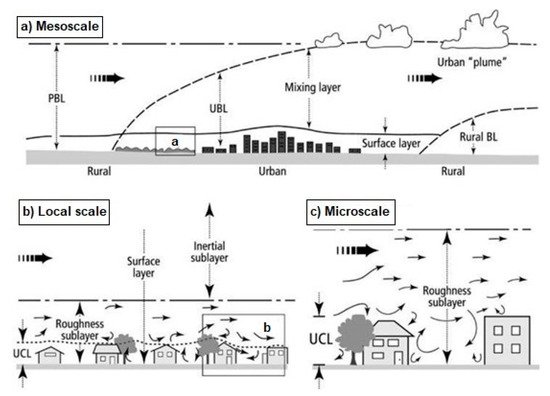
Figure 1. Three scales, mesoscale (a), local scale (b) and microscale (c), used to distinguish atmospheric processes in the urban area and the atmospheric layers: planetary boundary layer (PBL), the urban boundary layer (UBL), urban canopy layer (UCL) (Modified after Núñez Peiró et al.) [30][39].
The temperature difference between representative urban and rural weather stations defines UHI intensity [21][29]. Ziter et al. [31][41] demonstrated that the variation in daytime air temperature within Madison, United States, was comparable in magnitude to the temperature difference between the city centre and the surrounding rural landscape. Besides, the temperature variation in the city was most significant during high-heat events. For example, the study conducted by Cosgrove and Berkelhammer [32][42] showed that heat in the Chicago urban atmosphere could be transferred overland for up to nearly 70 km and up to about 40 km over Lake Michigan.
3. Contribution Factors to Urban Heat Island Formation
According to Oke [25][35] the potential causes of UHI are listed in Table 1. Based on the review of 75 studies, Deliami et al. [33][48] determined the most common contributing factors of UHI such as vegetation cover (44%), season (33%), built-up area (28%), day/night (25%), and population density (14%). These factors could be classified as controllable and uncontrollable (Figure 2), which further are divided as temporary effect variables (e.g., wind speed, cloud cover), permanent effect variables (e.g., green areas, building material, sky view factor) and cyclic effect variables (e.g., solar radiations, anthropogenic heat sources) [34][35][49,50].
].
The thermal behavior of urban materials depends on the thermal physical properties related to energy transport through a system (e.g., radiation, conduction, convection) and properties related to the thermodynamic or equilibrium state of a system (e.g., density, specific heat capacity) [39][56].The thermal balance of pavement structure depends on the amount of absorbed and stored solar radiation, released infrared radiation, heat transferred by convection to the air, the heat stored in the mass of material, and heat conducted to the ground [40][57].
Material(Dry State) |
Remarks |
Density(kg m−3 × 10³) |
Specific Heat(J kg−1 K−1 × 10³) |
Heat Capacity(J m−3K−1 × 10⁶) |
Thermal Conductivity(W m−1K−1) |
Thermal Diffusivity(m2s−1 × 10⁻⁶) |
Thermal Admittance(J m−2s−1/2) |
Asphalt |
|
2.11 |
0.92 |
1.94 |
0.75 |
0.38 |
1205 |
Concrete |
Aerated |
0.32 |
0.88 |
0.28 |
0.08 |
0.29 |
150 |
Dense |
2.40 |
0.88 |
2.11 |
1.51 |
0.72 |
1785 |
|
Stone |
Av. |
2.68 |
0.84 |
2.25 |
2.19 |
4.93 |
2220 |
Brick |
Av. |
1.83 |
| Altered Energy Balance Terms Leading to a Positive Thermal Anomaly | Features of Urbanization Underlying Energy Balance Changes |
|---|---|
| A. Canopy layer | |
| 1. Increased absorption of short-wave radiation | Canyon geometry—increased surface area and multiple reflections |
| 2. Increased long-wave radiation from the sky | Air pollution—greater absorption and re-emission |
| 3. Decreased long-wave radiation loss | Canyon geometry—reduction of sky view factor |
| 4. Anthropogenic heat source | Building and traffic heat losses |
| 5. Increased sensible heat storage | Construction materials—increased thermal admittance |
| 6. Decreased evapotranspiration | Construction materials—increased imperviousness |
| 7. Decreased total turbulent heat transport | Canyon geometry—reduction of wind speed |
| B. Boundary layer | |
| 1. Increased absorption of short-wave radiation | Air pollution—increased aerosol absorption |
| 2. Anthropogenic heat source | Chimney and stack heat losses |
| 3. Increased sensible heat input-entrainment from below | Canopy heat island—increased heat flux from canopy layer and roofs |
| 4. Increased sensible heat input-entrainment from above | Heat island, roughness—increased turbulent Entrainment |
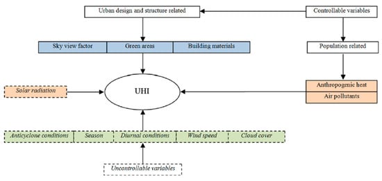
Figure 2. The causes of the Urban Heat Island effect [35][50].
Paved surfaces cover a significant percentage of urban areas and play an important role in UHI formation [10][36][37][15,53,54]. In Chicago, Illinois, paved surfaces (roads, parking areas, and sidewalks) cover 50–60% of commercial areas and about 27% of residential areas [19][25]. Similarly, in Sacramento, paved surfaces cover between 44–68% of commercial areas and 28% of residential areas [38][55
0.75 | |||||||
1.37 | 0.83 |
0.61 |
1065 |
||||
Clay tiles |
|
1.92 |
0.92 |
1.77 |
0.84 |
0.47 |
1220 |
The ability of materials to capture heat depends on thermal inertia in addition to other thermal properties. Thermal inertia is related to the ability or material to resist a variation in heat flow or temperature and is defined as the speed at which a material cools or heats up. Thus, inert material is a material that takes a long time to reach a new equilibrium temperature when subjected to a thermal perturbation [41][42][58,59].
Urban construction materials have a higher heat capacity and can store more heat than natural materials, such as trees, dry soil, and sand. Urban pavements with low thermal conductivity can heat up at the surface but will not transfer heat into the other pavement layers as fast as the pavement with higher conductivity. Regarding aggregate base materials or subgrade materials, the thermal conductivity depends on factors such as type of material, mineral content, moisture content, particle size, and overall density. Besides, the thermal behavior of pervious material depends on its porosity which influences surface energy fluxes [43][44][27,60].
The porosity of permeable pavements typically ranges between 10% and 30%, while the saturated liquid permeability ranges between 5 × 10⁻⁵ and 4 × 10⁻³s. The conventional dense pavement has porosity lower than 10%, and the liquid permeability is several orders of magnitude smaller [45][62]. Both higher porosity and higher permeability of the pavements enhance the evaporation rate and promote the evaporative cooling effect [46][47][48][63,64,65].
The transport of energy through the pavements related to radiation depends on albedo and emissivity. A part of solar radiation that reaches the pavement surface will be absorbed by the surface resulting in increased pavement thermal energy. An indicator of the energy reflected by the surface called albedo is measured on a scale from zero to one, where zero indicates that the surface absorbs all solar radiation and one that total solar radiation is reflected [47][64]. Emissivity refers to the ratio of energy radiated by the surface compared to the radiation emitted by a black body at the same temperature and determines the contribution of material to the UHI [44][47][48][60,64,65].
Compared to conventional concrete pavements, pervious concrete pavements have lower reflectivity, heat volumetric capacity, thermal conductivity, and absorb additional heat. The higher porosity pavements have a larger surface temperature than lower porosity pavements as they have higher thermal diffusivity, which decreases by porosity increase [45][62]. Void structure and the rougher surface of pervious pavement can reduce the surface’s net solar reflectance, thermal conductivity, and heat capacity, resulting in higher surface temperature than conventional pavement [47][64]. At the same time, the increases in thermal conductivity, diffusivity, and volumetric heat capacity decreased the maximum but not the minimum pavement near-surface temperature.
4. Consequences of the Urban Heat Island
One of the most important factors influencing the quality of life in urban areas is the urban microclimate [49][69]. The elevated temperatures in urban areas impact urban environmental quality and human well-being [50][70]. The consequences of the UHI are various such as degradation of the living environment, increased cooling energy usage and associated costs, intensification of air quality problems (e.g., the formation of large amounts of smog and air pollutants), impact on human health, comfort, and increased thermal stress and water quality deterioration [50][51][70,71].
Globally, heat extremes have adverse effects on human health and well-being, cause human discomfort and heat stress [52][53][72,73], and increase the risk of heat-related mortality [17][54][55][21,74,75]. According to Goggins et al. [56][76], in areas with high UHI intensity, a 1 °C rise above 29 °C can increase mortality by 4.1%. Murage et al. [57][77] found that heat exposure during the night contributes to heat-related mortality, and the impact is most prominent when hot nights follow hot days.
Extreme events such as heat waves significantly impact human life and are among the most harmful climate extremes to human society [58][82]. Climate change will impact heatwaves and make them more frequent, long-lasting, and more intense [59][19]. Further, the UHI effect may potentially increase the magnitude and duration of heat waves [43][27]. Zhao et al. [58][82] indicated that cities in temperate climate region show significant synergistic effects between UHI and heatwaves during the daytime. The simultaneous occurrence of the UHI effect and heatwave exacerbates thermal stress [58][60][82,83], particularly under anticyclonic conditions with low or negligible wind speeds, and can cause high mortality of highly vulnerable population groups [23][33].
One of the most critical factors that increases energy use in urban areas is the formation of UHI [20][28]. Higher air temperature can double energy consumption due to the increased use of cooling systems in commercial and residential buildings [12][40][14,57].
Elevated air temperatures increase electricity generation by power plants, leading to a higher level of air pollution and greenhouse gas (GHG) emissions [27][37]. Such conditions increase the rate of ground-level ozone formation, one of the major components of photochemical smog that is harmful to the environment. Photochemical smog is produced in photochemical reaction when primary air pollutants (e.g., carbon monoxide (CO), carbon dioxide (CO2) sulfur dioxide (SO2), nitrogen oxides (NOx), suspended particulate matter, and volatile organic compounds (VOCs) react with secondary air pollutants such as NO2 and ozone (O3) [12][16][61][14,20,84].
The temperatures of urban surfaces such as pavement and rooftop during the warm summer period can reach 27 °C to 50 °C higher than air temperatures [62][91]. High temperatures of urban surfaces can increase stormwater runoff temperatures and cause thermal pollution of receiving water bodies [63][64][22,23].
According to Xie et James [64][23], impervious surfaces and meteorological conditions are among the factors that have the most significant influence on urban stream temperatures. Generally, the average urban stream temperature increases linearly with increasing watershed imperviousness. The increase of impervious surface by 1% will increase the average urban stream water temperature by 0.08 °C.