Your browser does not fully support modern features. Please upgrade for a smoother experience.
Please note this is a comparison between Version 2 by Sirius Huang and Version 1 by Wilfried Yves Hamilton Adoni.
Earthquake early warning systems (EEWS) are crucial for saving lives in earthquake-prone areas. Earthquake early warning systems rely on a variety of advanced signal processing techniques and specific parameters to detect and analyze seismic waves in real time.
- earthquake early warning system (EEWS)
- disaster
- management
- internet of things
- cloud systems
1. Introduction
There are strong correlations between earthquakes, climate changes, and mining activities [6,7,8][1][2][3]. Many scientists have predicted that the frequency of earthquakes will keep increasing [9][4]. In [10][5], the first paper on the idea of earthquake early warning systems (EEWS) in 1985 was presented. These systems are networks of ground-based sensors that alert users when the earth starts to tremble.
EEWS operates under the assumption that, despite the slow speed at which seismic waves move, electronic alerts from the epicenter region may be delivered almost instantly. The process is as follows:
-
Several types of seismic waves radiate from an earthquake’s epicenter. Sensors are activated by P-waves, which are weaker but move more quickly. Thereafter, sensors send signals to cloud servers for processing.
-
Algorithms in the cloud server instantly determine the location, magnitude, and severity of an earthquake. How big is it? Who will suffer from this?
-
The technology sends out an alert before slower but more destructive S-waves and surface waves arrive.
Those who are close to the epicenter will not receive much, if any, warning beforehand, while those who are farther away could only have a few seconds to brace themselves. EWS may help reduce some of the injuries and damage caused by large earthquakes when used in conjunction with automated countermeasures such as stopping trains or turning off gas lines.
Recent years have seen a significant increase in the number of traditional as well as contemporary technology utilized in EEWSs [12,13,14][6][7][8]. As a consequence of this, effective integration of the numerous scientific fields is sought after in order to serve such crucial systems. In general, actions taken to reduce risks, conduct seismic hazard assessments, determine site specifications, and the like can be of assistance in this regard [15,16,17,18,19][9][10][11][12][13]. Developing a reliable EEWS necessitates solving a number of issues that are impacted by the ongoing difficulties associated with earthquake catastrophes. These issues include the observation of earthquake characteristics, and the environment type [20,21,22,23,24,25][14][15][16][17][18][19].
Radio-frequency identification, satellite systems, the Internet of Things (IoT), network functions virtualization (NFV), 5G, software-defined networks (SDN), data networks, and a variety of other technologies have all been the focus of significant research in recent years in an effort to lessen the damage that earthquakes cause [26,27,28,29,30,31,32,33,34][20][21][22][23][24][25][26][27][28]. For instance, satellite systems have been used to track earthquake movements, and IoT sensors have been used to detect earthquakes and provide early warnings. Furthermore, 5G and SDN technologies have been deployed for real-time communication and data transmission in emergency situations. These technologies have greatly enhanced the accuracy and speed of earthquake detection and warning systems and have improved the response time of emergency services.
Moreover, the integration of robots and the internet has the potential to be a significant breakthrough in this field. According to [35][29], a new integrated system named “robot-event” has been proposed, which is able to execute autonomous inspections and emergency responses to a severe event. The robot uses real-time image tracking to inspect the indoor environment and help any human victims found on the ground. It operates in structurally sound houses with moderate damage, focusing on situations where people are at risk from falling furniture. The system was tested indoors to assess its functionality and operation alongside a smart EEWS. This new technology has the potential to significantly reduce the risk of human casualties during an earthquake by providing timely and accurate information to emergency responders. Future research in this area could explore further the use of robotics, artificial intelligence, and the internet to develop more advanced and efficient EEWSs.
2. Seismic Waves and Seismic Signal Processing Techniques
Seismic activity is a key subject of investigation. Understanding how different types of structures respond to earthquake loads and finding out how to safeguard occupants of a structure in an earthquake are both aided by this knowledge.
The study of seismicity can help us better understand the many seismic wave types that are generated, allowing us to map both the regions that are earthquake-prone and those that are not. Studying a region’s seismic activity aids in establishing minimum safety requirements for that area, making it simpler for life to go on after an earthquake [97,98][30][31].
Acoustic energy, known as a seismic wave, can move through the Earth or another planetary body. It could be caused by a quake (or an earthquake more generally), a volcanic eruption, the movement of magma, a big landslide, or a sizable explosion brought on by human activity, such as mining, which releases low-frequency acoustic energy. Seismologists are responsible for investigating seismic waves. To record the waves, seismologists use accelerometers, hydrophones, or seismometers that are submerged in water [99][32]. It is important to differentiate seismic waves from seismic noise, also known as ambient vibration, which is characterized by a continuous low-amplitude vibration and can be caused by a wide variety of natural and artificial sources. Arrays of sensors are typically used in seismic signal processing, which is followed by signal conditioning and data fusion. An ADC converter is then used to digitize the gathered data, and a microcontroller is used to process it. This is referred to as an IoT node in the context of the IoT, and it is shown in Figure 1.
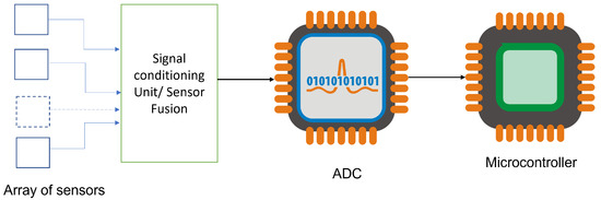
Figure 1.
IoT sensor node for EEWS.
It is possible to differentiate between the two types of seismic waves known as body waves, which move through the inside of the planet, and surface waves, which move along the surface of the planet. Body waves flow through the interior of the Earth in a manner that is determined by the paths that are created by material properties such as density and modulus (stiffness). Temperature, chemical composition, and the state of the material all have an effect on the material’s modulus and density. This phenomenon can be compared to the refraction of light waves. On the basis of how particles move, body waves can be divided into two distinct categories: primary and secondary waves. Around the year 1830, the French mathematician Siméon Denis Poisson identified this distinction as follows [100][33]:
-
Primary waves, also referred to as P-waves, are longitudinal compressional waves that move through the earth in a straight line. These waves are known as “primary” waves because they arrive first at seismograph stations, traveling faster through the earth than other types of waves. P-waves are pressure waves that can travel through any material, including fluids, and move at a speed that is around 1.7 times faster than that of S-waves. In contrast to S-waves, which are transverse waves that move side-to-side, P-waves are compression waves that cause particles in the material they are traveling through to move back and forth in the direction of the wave’s propagation. They take the form of sound waves in the air and move at the same velocity as sound waves, which is around 330 m per second on average. The ability of P-waves to travel through any material allows them to be used to study the interior of the earth. By measuring the time taken for P-waves to travel through the earth from an earthquake’s epicenter to a seismograph station, scientists can calculate information about the earth’s internal structure. For example, the average speed of P-waves in granite is roughly 5000 m per second, while in water, it is around 1450 m per second. This information can be used to create a detailed model of the Earth’s interior.
-
S-waves, also known as secondary shear waves, are transverse waves that cause the ground to shift in a direction perpendicular to their propagation during an earthquake. These waves arrive at seismograph stations after P-waves, which are faster. S-waves have a horizontal polarization and move in a horizontal direction, causing the ground to shift from side to side. However, S-waves can only travel through solids since liquids and gases do not support shear forces. They move through any solid medium at a speed that is approximately 60% slower than P-waves. The absence of S-waves in the outer core of the Earth is consistent with the presence of liquid. This is because S-waves cannot propagate through liquids, and their absence indicates that the outer core is predominantly liquid. However, P-waves can propagate through liquids, which is why they can travel through the entire Earth. The study of seismic waves and their behavior has provided scientists with valuable insights into the structure and composition of the Earth’s interior.
The path that seismic surface waves take along the surface of the Earth [101][34]. These are an example of a type of surface wave known as mechanical surface waves. They are referred to as surface waves because their strength decreases as they go away from the ocean’s surface. They move at a much slower pace compared to seismic body waves (P and S). The amplitude of surface waves can reach several millimeters during particularly powerful earthquakes.
Seismographs that are situated at a greater distance from the epicenter of an earthquake are unable to detect the high frequencies of the first P wave. In contrast, seismographs that are situated closer to the epicenter are able to record both the P and S waves that are generated when an earthquake takes place [102][35].
The problems that are associated with seismic data are probably unmatched by any others. During the course of the past few decades, the amounts of such data have nearly multiplied exponentially [103][36]. In recent acquisition studies, petabits of data are being processed on a daily basis. This requires massive processing capabilities. It should, therefore, not come as a surprise that data formats have evolved significantly over the years and that they have been altered to meet particular workflows or software solutions, which has added to the complexity of managing data [104][37].
In recent years, the industry of exploration and production has been dealing with “big data” in the form of seismic data [105][38]. This data is collected during seismic surveys. As more and more varieties of data are gathered and reprocessed for a variety of purposes, the amount and volume of data continue to grow at an alarming rate. It is necessary to locate and manage both field and prestack data because new insights can be derived from old data by applying updated seismic processing methods. Because of this, it is important to keep track of both sets of data. Several companies made the decision to store this information on tapes because of the massive size of seismic data files and the prohibitively expensive cost of disk space. However, tapes were difficult to handle and regularly went missing, so this was not an ideal solution. Web-based viewers and administration tools make it easier to discover and handle data from anywhere in the world. At the same time, tiered storage and cloud storage offer new and more cost-effective means of keeping enormous seismic datasets [106][39]. Figure 2 shows the enhancements of the utilized earthquake measurement.
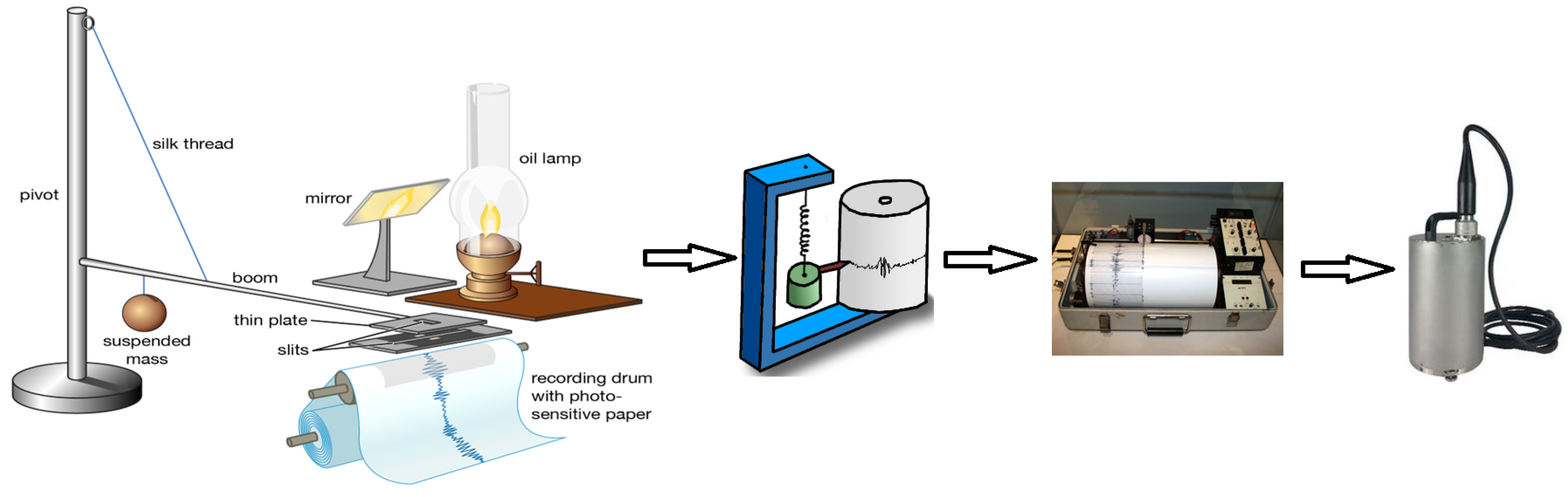
Figure 2.
Earthquake measurement evolution.
Seismic wave analysis is a key component of earthquake early warning systems, as it enables the detection and characterization of seismic waves in real-time [107,108][40][41]. One of the most widely used signal processing techniques in seismic wave analysis is the Fourier transform, which is used to transform time-domain signals into frequency-domain signals [109,110][42][43]. In earthquake early warning systems, the Fourier transform is often used to analyze the spectral content of seismic waves, which can provide important information about the location, magnitude, and duration of an earthquake [111][44]. The Fourier transform is also used to filter out noise and unwanted signals from seismic data, improving the accuracy of earthquake detection and analysis [112][45].
Another advanced signal processing technique used in seismic wave analysis is wavelet analysis, which is used to analyze signals that are both time-varying and non-stationary [113,114,115][46][47][48]. In earthquake early warning systems, wavelet analysis is often used to detect and analyze seismic waves that have complex frequency components, such as those generated by slow earthquakes or volcanic activity [116,117][49][50]. By decomposing a seismic waveform into its constituent frequency components, wavelet analysis can provide more detailed information on the characteristics of seismic waves, such as their frequency content, duration, and amplitude [118,119][51][52].
In addition to these advanced signal processing techniques, earthquake early warning systems also rely on a variety of specific parameters to optimize their performance [120,121][53][54]. These parameters include sampling rates, window sizes, and filter cutoff frequencies, among others. Sampling rates determine how often seismic data is collected and stored, while window sizes determine the length of time over which seismic data is analyzed. Filter cutoff frequencies determine which frequency components of a seismic waveform are analyzed and are often used to remove noise and unwanted signals from seismic data.
3. IoT-Cloud-Based EEWS
This section will highlight the significant significance that the IoT-Cloud technology plays in EEWS. In point of fact, the application of IoT-Cloud strategies has been of assistance to EEWS before and after disasters. The IoT has revolutionized the way we interact with the physical world, and one of its most promising applications is in the detection and prediction of natural disasters such as earthquakes. The basic idea behind using IoT for earthquake detection is to deploy a network of sensors that can detect seismic activity and transmit the data to a central server for analysis. These sensors can be embedded in buildings, bridges, and other structures, as well as in the ground itself. By analyzing the data from these sensors, it is possible to detect the onset of an earthquake and predict its magnitude and location. One of the key advantages of using IoT for earthquake detection is that it allows for real-time monitoring of seismic activity. Traditional methods of earthquake detection rely on seismometers, which are expensive and require a lot of maintenance. They also typically only provide data after an earthquake has already occurred. In contrast, IoT sensors can provide continuous data in real-time, allowing for EWS to be put in place [162,163,164][55][56][57]. This can be particularly useful in areas prone to earthquakes, where early warning can save lives and reduce damage. Another advantage of using IoT for earthquake detection is that it can provide more denser data network than traditional methods. IoT sensors can be placed in a wider variety of locations, such as inside buildings or underground, allowing for a more comprehensive picture of seismic activity. They can also provide data on other factors that can affect the impact of an earthquake, such as soil conditions and building materials. This information can be used to develop better models for earthquake prediction and to design buildings and infrastructure that are more resistant to seismic activity. The use of IoT for earthquake detection has the potential to revolutionize the way we prepare for and respond to earthquakes. By providing real-time data and more comprehensive information on seismic activity, IoT sensors can improve our ability to predict earthquakes and minimize their impact. As the technology continues to develop, we can expect to see more widespread deployment of IoT sensors and more sophisticated analysis techniques, leading to even better earthquake detection and prediction capabilities. A generic EEWS architecture typically consists of three main components: the seismic network, the processing center, and the alert distribution system [165][58]. The seismic network comprises a set of sensors deployed across a region of interest, which detect and record seismic waves generated by earthquakes. The sensor data is transmitted to the processing center, where it is analyzed in real-time using algorithms and models to estimate the location, magnitude, and other characteristics of the earthquake [166][59]. The alert distribution system then disseminates the earthquake alert to end-users through various channels, such as mobile devices, sirens, and public announcements [167][60]. The underlying infrastructure of the EEWS includes a variety of hardware and software components, including seismometers, communication networks, computing systems, and databases [168][61]. The seismometers are typically deployed in a dense network to ensure high spatial resolution and coverage, and they are connected to a communication network that transmits the sensor data to the processing center [169][62]. The processing center comprises a set of computing systems that perform real-time data analysis, using a variety of algorithms and models to estimate the earthquake parameters [170][63]. The alert distribution system includes a set of communication channels and protocols that disseminate the alert to end-users, as well as a database that stores historical and real-time earthquake data [171][64]. The interactions between these components are tightly coordinated to ensure timely and accurate earthquake alerts, which can help to mitigate the impact of earthquakes and save lives [172][65]. In [173][66], the authors developed CrowdQuake, a DL-based seismic detection system. Utilizing a dense IoT network composed of MEMS nodes, the system employs a multi-head convolution neural network to analyze a large quantity of observed acceleration data. During the model validation procedure, the scientists got data from the National Research Institute for Earth Science and Disaster Prevention (NIED) and measured the precision-recall, accuracy, and noise level. The developed system could process data from up to 8000 IoT sensors, and identifying an earthquake required only a few seconds of processing time, according to the researchers. In [174][67], an advanced EEWS supported by an IoT network that operates on the basis of real-time alerts has been established. The network utilized MEMS accelerometers and an Arduino Cortex M4 CPU for measuring acceleration. This technique employs ML to improve the accuracy and latency in earthquake detection. The model was constructed using data gathered locally by the MEMS accelerometer nodes that were installed. In [175][68], IoT acceleration nodes were designed explicitly for earthquake detection. Two methods are used to utilize these nodes: a technique of standalone and a technique of client-server. The first technique is more commonly used, while the client-server technique is more precise but requires high-performance servers and network infrastructure to manage data acceleration from multiple client machines. Basic earthquake detection methods can be independently explored on less capable mobile nodes. However, this may result in false alarms. To overcome this limitation, a cooperative method that uses a large number of mobile phones located in close proximity to one another is employed. This creates a seismic network that can detect earthquakes and monitors any shaking caused by human activity, mechanical vibrations, earthquakes, etc. By relying on a primary neural network, a motion similar to an earthquake detected by a smartphone is transmitted to other cellphones in the immediate area using a multi-hop mode. Furthermore, every mobile phone in the network determines and notifies the network of an earthquake, then triggers an alarm after obtaining detection data from other smartphones in its immediate vicinity. This technique improves the earthquake detection capabilities of a standalone method that does not use any system or network infrastructures. In [176][69], a predictive model that combines IoT devices and ML techniques was used to detect geological landslide occurrences. The predictive model was trained with geotechnical parameters such as soil shear strength, soil moisture, rain intensity, terrain slope, and more. The actual hardware used for this purpose consisted of a collection of sensors that gathered real-time information on the topography and soil. In [177][70], the authors proposed a compute offloading system architecture that can be implemented on Internet-connected drones. They conducted an in-depth experimental study to compare the efficiency of cloud computing offloading strategy with that of the edge computing strategy for DL solutions in the context of unmanned aerial vehicles (UAVs). The authors investigated the balance between the computational cost of the two alternative options communications in an experiment. In [53][71], a DL paradigm based on integrating autoencoder (AE) and CNN was developed to immediately determine earthquake magnitude and position three seconds after the P-wave begins. The authors referred to it as CNN and 3s AE (3S-AE-CNN). The data set used in the study was monitored by three stations of the Hi-net seismic network in Japan, and the approach was evaluated using data from 12,200 separate occurrences (109.80 thousand 3 s three-component seismic windows). The model simplifies the extraction of essential waveform properties, resulting in a higher degree of credibility in earthquake parameter assessment. The suggested model predicts magnitude, latitude, and longitude with an accuracy of within 28 × 10−6−6, 3.3 × 10⁻⁶−6, and 100 × 10−6−6 degrees, respectively. That model immediately communicates event features to a sink IoT node. It provides guidance to the relevant administration on how to proceed. It is noted that AE has proved beneficial in feature extraction regardless of the application [178][72]. The framework for earthquake prediction proposed in [179][73] is a novel approach based on federated learning (FL). This FL framework outperformed the previously developed ML model for earthquake estimation through an IoT gateway in terms of reliability and accuracy. The model achieved an accuracy of 88% by analyzing multidimensional data over a 100 km radial area, excluding the Western Himalayas, and studying the data. In [180][74], an EEW based on an IoT and an ML model was suggested to predict tsunamis using tsunami data dating back to 2100 BC and was trained on earthquake parameters in the dataset. It achieved an accuracy of 95% in predicting earthquake location, depth, and magnitude. The fragility of the problem that is being targeted, as well as its direct effect on human life, makes it imperative that a solution be found that is intelligent, trustworthy, and flexible despite the considerable efforts that have been put into developing the state-of-the-art. This section throws light on the primary research explorations that have been done in this area. The primary efforts in developing IoT for the EEWS are outlined in detail in Table 1.Table 1.
IoT-based EEWS main efforts.
Overall, the use of drones in earthquake disaster detection and management has the potential to save lives, speed up response times, and improve the efficiency of emergency services. As technology continues to advance, it is likely that drones will become an even more important tool in disaster management, helping to mitigate the effects of earthquakes and other natural disasters. Figure 5 shows the role of UAVs for three scenarios of pre, during, and post-disaster situations.
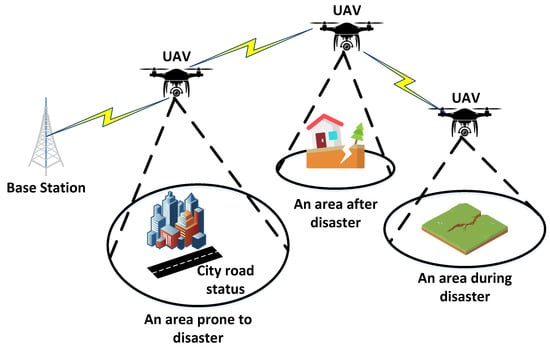
Figure 5.
Three scenarios of disaster and the role of UAV.
Evaluating the performance and reliability of IoT-enabled earthquake early warning systems (EEWS) is crucial for ensuring their effectiveness in real-world scenarios. There are several techniques that can be used to provide a comprehensive evaluation of the performance and reliability of these systems, including simulation testing, field testing, and data-driven analysis:
In order to prevent the loss of human life, the implementation of an EEWS is an absolute necessity. In order to effectively manage disasters and reduce the danger of earthquakes, it is essential to have the ability to promptly detect the features of an earthquake. With technologies already in place, such as the IoT network, social media, global positioning system (GPS), and mobile nodes, these attributes can be sent to help mitigate the effects of a catastrophic earthquake.
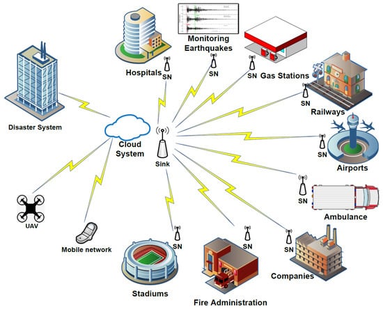
Figure 3 depicts a comprehensive EEWS with many administrations assisting in relieving the earthquake tragedy. The EEWS will include complete statistics regarding hospitals, railways, fire services, ambulances, airports, and so on based on these administrations. This proposed system does integrate social media, IoT technologies, cloud systems, and mobile systems. It operates in two stages. The first stage is pre-disaster, as ML models are used to detect the commencement of the principal wave. This procedure is extremely advantageous for risk minimization, such as rapid shutting down of nuclear power plants, electrical producers, and so on. The second phase begins after the disaster has occurred, with the goal of mitigating/reducing the disaster’s impacts. Using an integrated system, for example, allows for more accurate statistics regarding the affected people, buildings, utilities, and areas. As a result, an effective evacuation strategy can be implemented.
 A solution that is both flexible and intelligent and that is able to deal with complex problems in a relatively short amount of time is required for such a system. ML has the potential to play a significant and critical part in the administrations that are interconnected and working on achieving successful EWS among the variety of existing current techniques. ML is a promising method that works regardless of the data type, format, length, and other factors such as these.
Indeed, real-time monitoring takes place across all of the dispersed organizations shown in Figure 3, which serves as the foundation for a reliable EEWS. As a consequence of this, the transfer of data between various entities needs to be thoroughly investigated and estimated. After that, ML models are utilized to zero in on the current status of each object and even provide an estimate for a certain word. As a consequence of this, those institutions are capable of making useful contributions prior to, during, and after earthquake disasters. To put it another way, a technique such as this can assist with the management of earthquake catastrophes, the reduction of earthquake risks, and evacuation tactics. As a consequence of this, the performance of the EEWS improves in direct proportion to the quality of the ML model. Figure 4 provides a visual representation of the interaction between trains as a specific administration used in the process of full EEWS, the data processing, and the research done. To be more precise, earthquake data is monitored to be sent for processing using the IoT network in order to carry out the desired check and determine the correct decision to send to the railway system for suitable action using an ML model and the railway information of the disaster location. This process is repeated until the appropriate decision is made.
A solution that is both flexible and intelligent and that is able to deal with complex problems in a relatively short amount of time is required for such a system. ML has the potential to play a significant and critical part in the administrations that are interconnected and working on achieving successful EWS among the variety of existing current techniques. ML is a promising method that works regardless of the data type, format, length, and other factors such as these.
Indeed, real-time monitoring takes place across all of the dispersed organizations shown in Figure 3, which serves as the foundation for a reliable EEWS. As a consequence of this, the transfer of data between various entities needs to be thoroughly investigated and estimated. After that, ML models are utilized to zero in on the current status of each object and even provide an estimate for a certain word. As a consequence of this, those institutions are capable of making useful contributions prior to, during, and after earthquake disasters. To put it another way, a technique such as this can assist with the management of earthquake catastrophes, the reduction of earthquake risks, and evacuation tactics. As a consequence of this, the performance of the EEWS improves in direct proportion to the quality of the ML model. Figure 4 provides a visual representation of the interaction between trains as a specific administration used in the process of full EEWS, the data processing, and the research done. To be more precise, earthquake data is monitored to be sent for processing using the IoT network in order to carry out the desired check and determine the correct decision to send to the railway system for suitable action using an ML model and the railway information of the disaster location. This process is repeated until the appropriate decision is made.
-
Simulation testing involves creating a virtual environment that simulates real-world conditions, including seismic activity and sensor data [200,201][85][86]. Simulation testing allows researchers to test the performance of an EEWS system under different scenarios, such as different magnitudes and distances of earthquakes and different types of seismic waves [202][87]. This technique can also be used to evaluate the effectiveness of different algorithms and parameters used in the system [203][88].
-
Field testing involves deploying an EEWS system in real-world conditions and collecting data on its performance and reliability [204,[89205]][90]. Field testing can provide valuable insights into the system’s performance under actual operating conditions, which may differ from those in a simulated environment. Field testing can also help to identify potential issues with the system, such as sensor malfunction or communication failures [206][91]. This technique can be time-consuming and resource-intensive, but it provides valuable data on the system’s performance and reliability in real-world scenarios [207][92]
- .
| [ | |||||
| 177 | |||||
| ][70] | UAV nodes | ODLOS | Aerial images data | Received frames/sec | Local drones |
| [185][76] | Smartphones | S-D environment | Acceleration data | Earthquake data | NIED and USGS |
| [188][77] | Seismometer | UG | GPS and weak motion data | Earthquake data | IRIS and NIED |
| [173][66] | MEMS | UG | Acceleration data | Acceleration, SNR | NIED |
| [174][67] | Arduino Cortex M4 | UG | Acceleration data | Earthquake detection accuracy and detection latency | Local data observed by MEMS accelerometers |
| [175][68] | Acceleration nodes | IDNLOS | Acceleration data | PGA and human activity | Local distributed smartphones |
| [176][69] | Soil and terrain nodes | UG | Soil moisture, shear strength of the soil, severity of the rain | Soil moisture, Soil shear strength, rain severity | GSI |
| [53][71] | Tmote Sky | ID and OD | Seismic velocity data | Location and magnitude | JMA and Hi-net |
| [179,195][73][78] | IoT gateway | UG | Seismic waveform | Earthquake predictions | Local datasets and regional data |
| [183][79] | Acceleration nodes | UG | Acceleration data | PGA | NIED |
| [185][76] | MEMS | Noisy environments | Seismic waveform | P-wave arrival | STEAD |
| [182][80] | Raspberry Pi | Mesh network | Seismic waveform | Local earthquake | Locally observed |
| [196][81] | SSN/SOSA ontology | UW | Volcanic data | Volcano-tectonic, long-period earthquakes, underwater explosions, and quarry blasts | Local data |
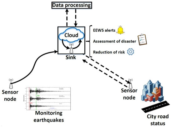
Figure 3.
A general architecture of EWS.
Figure 4.
A pattern of Iot-based EEWS.
The authors of [197][82] mentioned the same approach of benefiting from UAVs as Aerial Base Stations (ABSs) to provide connectivity instead of traditional base stations. They proposed two trajectory planning algorithms using a k-value selection method and K-means centroids for UAVs. These UAVs served to the clusters of user equipment. By enhancing the study, the authors also gave two methods for cluster head selection to support continuous connectivity via UAVs and cluster heads.
The authors of [198][83] suggested a system to find the damage degrees of various earthquake region parts such as roads and riverways. They used single-rotor and six-rotor UAVs and took visible light images of the region parts. Once the image quality evaluation was done according to the image contrast, the image blur, and the image noise formulas, the aerial images were analyzed with Gray Level Cooccurrence Matrix, the Tamura, and the Gabor wavelet features. Lastly, the SVM classifier was used to obtain the damage levels.
The authors of [199
- Data-driven analysis involves analyzing large datasets generated by an EEWS system to identify patterns and trends, which can provide insights into its performance and reliability [208][93]. Data-driven analysis can be used to identify correlations between sensor data and earthquake characteristics, such as magnitude, duration, and intensity [209][94]. This technique can also be used to identify anomalies in sensor data, which may indicate issues with the system’s performance or reliability [210][95]. Data-driven analysis can provide valuable insights into the performance and reliability of an EEWS system over long periods of time [211][96].
By using a combination of these techniques, researchers can gain a more comprehensive understanding of the performance and reliability of IoT-enabled EEWS systems. This can help to identify areas for improvement and ultimately improve the effectiveness of these systems in mitigating the impact of earthquakes.
Integrating advanced technologies such as ML algorithms, distributed computing, and edge computing into EEWS systems can improve their accuracy and effectiveness. However, there are several challenges and considerations associated with these technologies. For example, ML algorithms require large amounts of data and computational resources to train and optimize, which may be difficult to obtain in the context of EEWS systems [212,213][97][98]. Distributed computing can improve the scalability and fault tolerance of EEWS systems, but it also introduces additional complexity and overhead in terms of communication and coordination [214,215,216,217][99][100][101][102]. Edge computing can improve the responsiveness and efficiency of EEWS systems by processing data closer to the source. Still, it also requires careful management of resources and trade-offs between processing power and energy consumption [218,219][103][104]. In addition, the implementation of these advanced technologies can be complex and may require significant expertise and resources. Furthermore, there may be limitations associated with the hardware and software infrastructure of EEWS systems, such as sensor networks and communication protocols, which may need to be upgraded or modified to support these technologies. Therefore, while integrating advanced technologies into EEWS systems has the potential to improve their accuracy and effectiveness, careful consideration of the trade-offs and implementation complexities is necessary to ensure their successful deployment and operation.
References
- Sadhukhan, B.; Chakraborty, S.; Mukherjee, S. Investigating the relationship between earthquake occurrences and climate change using RNN-based deep learning approach. Arab. J. Geosci. 2022, 15, 31.
- Dang, P.; Cui, J.; Liu, Q.; Li, Y. Influence of source uncertainty on stochastic ground motion simulation: A case study of the 2022 Mw 6.6 Luding, China, earthquake. Stoch. Environ. Res. Risk Assess. 2023, 37, 2943–2960.
- Chen, J.; Wen, L.; Bi, C.; Liu, Z.; Liu, X.; Yin, L.; Zheng, W. Multifractal analysis of temporal and spatial characteristics of earthquakes in Eurasian seismic belt. Open Geosci. 2023, 15, 20220482.
- Scholz, C.H.; Sykes, L.R.; Aggarwal, Y.P. Earthquake Prediction: A Physical Basis: Rock dilatancy and water diffusion may explain a large class of phenomena precursory to earthquakes. Science 1973, 181, 803–810.
- Heaton, T.H. A model for a seismic computerized alert network. Science 1985, 228, 987–990.
- Abdalzaher, M.S.; Elsayed, H.A.; Fouda, M.M.; Salim, M.M. Employing Machine Learning and IoT for Earthquake Early Warning System in Smart Cities. Energies 2023, 16, 495.
- Abdalzaher, M.S.; Moustafa, S.S.; Hafiez, H.A.; Ahmed, W.F. An optimized learning model augment analyst decisions for seismic source discrimination. IEEE Trans. Geosci. Remote Sens. 2022, 60, 1–12.
- Moustafa, S.S.; Abdalzaher, M.S.; Khan, F.; Metwaly, M.; Elawadi, E.A.; Al-Arifi, N.S. A Quantitative Site-Specific Classification Approach Based on Affinity Propagation Clustering. IEEE Access 2021, 9, 155297–155313.
- Moustafa, S.S.; Abdalzaher, M.S.; Abdelhafiez, H. Seismo-Lineaments in Egypt: Analysis and Implications for Active Tectonic Structures and Earthquake Magnitudes. Remote Sens. 2022, 14, 6151.
- Cremen, G.; Galasso, C.; Zuccolo, E. Investigating the potential effectiveness of earthquake early warning across Europe. Nature Commun. 2022, 13, 639.
- Elhadidy, M.; Abdalzaher, M.S.; Gaber, H. Up-to-date PSHA along the Gulf of Aqaba-Dead Sea transform fault. Soil Dyn. Earthq. Eng. 2021, 148, 106835.
- Dong, Y.; Gao, C.; Long, F.; Yan, Y. Suspected Seismo-Ionospheric Anomalies before Three Major Earthquakes Detected by GIMs and GPS TEC of Permanent Stations. Remote Sens. 2021, 14, 20.
- Abdalzaher, M.S.; El-Hadidy, M.; Gaber, H.; Badawy, A. Seismic hazard maps of Egypt based on spatially smoothed seismicity model and recent seismotectonic models. J. Afr. Earth Sci. 2020, 170, 103894.
- Allen, R.M.; Melgar, D. Earthquake early warning: Advances, scientific challenges, and societal needs. Annu. Rev. Earth Planet. Sci. 2019, 47, 361–388.
- Kumar, R.; Mittal, H.; Sharma, B. Earthquake Genesis and Earthquake Early Warning Systems: Challenges and a Way Forward. Surv. Geophys. 2022, 43, 1143–1168.
- Kodera, Y.; Hayashimoto, N.; Tamaribuchi, K.; Noguchi, K.; Moriwaki, K.; Takahashi, R.; Morimoto, M.; Okamoto, K.; Hoshiba, M. Developments of the nationwide earthquake early warning system in Japan after the 2011 M w 9.0 Tohoku-Oki earthquake. Front. Earth Sci. 2021, 9, 726045.
- Kodera, Y.; Saitou, J.; Hayashimoto, N.; Adachi, S.; Morimoto, M.; Nishimae, Y.; Hoshiba, M. Earthquake early warning for the 2016 Kumamoto earthquake: Performance evaluation of the current system and the next-generation methods of the Japan Meteorological Agency. Earth Planets Space 2016, 68, 202.
- McGuire, J.J.; Smith, D.E.; Frankel, A.D.; Wirth, E.A.; McBride, S.K.; de Groot, R.M. Expected Warning Times from the ShakeAlert Earthquake Early Warning System for Earthquakes in the Pacific Northwest; Technical Report; US Geological Survey: Reston, VA, USA, 2021.
- Chung, A.I.; Meier, M.A.; Andrews, J.; Böse, M.; Crowell, B.W.; McGuire, J.J.; Smith, D.E. ShakeAlert earthquake early warning system performance during the 2019 Ridgecrest earthquake sequence. Bull. Seismol. Soc. Am. 2020, 110, 1904–1923.
- Zhu, M.; Chen, F.; Zhou, W.; Lin, H.; Parcharidis, I.; Luo, J. Two-Dimensional InSAR Monitoring of the Co- and Post-Seismic Ground Deformation of the 2021 Mw 5.9 Arkalochori (Greece) Earthquake and Its Impact on the Deformations of the Heraklion City Wall Relic. Remote Sens. 2022, 14, 5212.
- Mei, G.; Xu, N.; Qin, J.; Wang, B.; Qi, P. A survey of Internet of Things (IoT) for geohazard prevention: Applications, technologies, and challenges. IEEE Internet Things J. 2019, 7, 4371–4386.
- Li, X.; Lu, R.; Liang, X.; Shen, X.; Chen, J.; Lin, X. Smart community: An internet of things application. IEEE Commun. Mag. 2011, 49, 68–75.
- Ghamry, E.; Mohamed, E.K.; Abdalzaher, M.S.; Elwekeil, M.; Marchetti, D.; De Santis, A.; Hegy, M.; Yoshikawa, A.; Fathy, A. Integrating pre-earthquake signatures from different precursor tools. IEEE Access 2021, 9, 33268–33283.
- Yue, Y.; Chen, F.; Chen, G. Pre-Seismic Anomaly Detection from Multichannel Infrared Images of FY-4A Satellite. Remote Sens. 2023, 15, 259.
- Franchi, F.; Marotta, A.; Rinaldi, C.; Graziosi, F.; Fratocchi, L.; Parisse, M. What can 5G do for public safety? Structural health monitoring and earthquake early warning scenarios. Sensors 2022, 22, 3020.
- Abdalzaher, M.S.; Elsayed, H.A. Employing data communication networks for managing safer evacuation during earthquake disaster. Simul. Model. Pract. Theory 2019, 94, 379–394.
- Peleli, S.; Kouli, M.; Vallianatos, F. Satellite-Observed Thermal Anomalies and Deformation Patterns Associated to the 2021, Central Crete Seismic Sequence. Remote Sens. 2022, 14, 3413.
- Abd Alzaher, M.S.; Elsayed, H.A.; Kayed, S.I.; Anis, W.R. Road Traffic Modeling using Data Communication Networks. Int. J. Comput. Appl. 2011, 975, 8887.
- Lin, T.H.; Huang, J.T.; Putranto, A. Integrated smart robot with earthquake early warning system for automated inspection and emergency response. Nat. Hazards 2022, 110, 765–786.
- Yilmaz, Ö. Seismic Data Analysis: Processing, Inversion, and Interpretation of Seismic Data; Society of Exploration Geophysicists: Houston, TX, USA, 2001.
- Moustafa, S.S.; Mohamed, G.E.A.; Elhadidy, M.S.; Abdalzaher, M.S. Machine learning regression implementation for high-frequency seismic wave attenuation estimation in the Aswan Reservoir area, Egypt. Environ. Earth Sci. 2023, 82, 307.
- Wear, K.A.; Gammell, P.M.; Maruvada, S.; Liu, Y.; Harris, G.R. Improved measurement of acoustic output using complex deconvolution of hydrophone sensitivity. IEEE Trans. Ultrason. Ferroelectr. Freq. Control 2014, 61, 62–75.
- Darrigol, O. Between hydrodynamics and elasticity theory: The first five births of the Navier-Stokes equation. Arch. Hist. Exact Sci. 2002, 56, 95–150.
- El Hady, A.; Machta, B.B. Mechanical surface waves accompany action potential propagation. Nat. Commun. 2015, 6, 6697.
- Bolt, B.; Tsai, Y.; Yeh, K.; Hsu, M. Earthquake strong motions recorded by a large near-source array of digital seismographs. Earthq. Eng. Struct. Dyn. 1982, 10, 561–573.
- Margrave, G.F.; Lamoureux, M.P.; Henley, D.C. Gabor deconvolution: Estimating reflectivity by nonstationary deconvolution of seismic data. Geophysics 2011, 76, W15–W30.
- Diviacco, P. An open source, web based, simple solution for seismic data dissemination and collaborative research. Comput. Geosci. 2005, 31, 599–605.
- Yan, X.; Zhang, M.; Wu, Q. Big-data-driven pre-stack seismic intelligent inversion. Inf. Sci. 2021, 549, 34–52.
- Huang, L.; Dong, X.; Clee, T.E. A scalable deep learning platform for identifying geologic features from seismic attributes. Lead. Edge 2017, 36, 249–256.
- Zhu, D.; Cui, J.; Li, Y.; Wan, Z.; Li, L. Adaptive Gaussian mixture model and convolution autoencoder clustering for unsupervised seismic waveform analysis. Interpretation 2022, 10, T181–T193.
- Ayu, H.; Sarwanto, S. Analysis of seismic signal in order to determine subsurface characteristics. J. Phys. Conf. Ser. 2019, 1375, 012079.
- Krebes, E.S. Seismic Wave Theory; Cambridge University Press: Cambridge, UK, 2019.
- Eng, M.; Eng, M.; Eng, M.; Pytel, W.; Eng, M. Time-frequency characteristic of seismic waves observed in the lower silesian copper basin. Int. Multidiscip. Sci. GeoConf. SGEM 2019, 19, 693–700.
- Dong, L.; Song, D.; Liu, G. Seismic wave propagation characteristics and their effects on the dynamic response of layered rock sites. Appl. Sci. 2022, 12, 758.
- Qi, P.; Wang, Y. Seismic time–frequency spectrum analysis based on local polynomial Fourier transform. Acta Geophys. 2020, 68, 1–17.
- Wirsing, K. Time frequency analysis of wavelet and Fourier transform. In Wavelet Theory; InTech Open: London, UK, 2020.
- Du, J.; Wu, J.; Jing, L.; Li, S.; Zhang, Q. Seismic Wavelet Analysis Based on Finite Element Numerical Simulation. J. Geosci. Environ. Prot. 2023, 11, 220–228.
- Long, L.; Wen, X.; Lin, Y. Denoising of seismic signals based on empirical mode decomposition-wavelet thresholding. J. Vib. Control 2021, 27, 311–322.
- Moriya, H. Identification of similar seismic waves using the phase-only correlation function and wavelet transform. Energies 2021, 14, 4527.
- He, Z.; Ma, S.; Wang, L.; Peng, P. A novel wavelet selection method for seismic signal intelligent processing. Appl. Sci. 2022, 12, 6470.
- Zhang, T.; Xu, Q.; Chen, J.; Li, J. Nonlinear seismic response and index correlation of high arch dams under cross-stream oblique incidence of near-fault SV waves based on wavelet decomposition. Soil Dyn. Earthq. Eng. 2023, 164, 107635.
- Adhikari, B.; Dahal, S.; Karki, M.; Mishra, R.K.; Dahal, R.K.; Sasmal, S.; Klausner, V. Application of wavelet for seismic wave analysis in Kathmandu Valley after the 2015 Gorkha earthquake, Nepal. Geoenviron. Disasters 2020, 7, 2.
- Longjun, X.; Yabin, C. Easy detection for the high-pass filter cut-off frequency of digital ground motion record based on STA/LTA method: A case study in the 2008 Wenchuan mainshock. J. Seismol. 2021, 25, 1281–1300.
- Chen, S.; Cao, S.; Sun, Y.; Lin, Y.; Gao, J. Seismic time-frequency analysis via time-varying filtering based empirical mode decomposition method. J. Appl. Geophys. 2022, 204, 104731.
- Ding, L.; Zhou, C.; Deng, Q.; Luo, H.; Ye, X.; Ni, Y.; Guo, P. Real-time safety early warning system for cross passage construction in Yangtze Riverbed Metro Tunnel based on the internet of things. Autom. Constr. 2013, 36, 25–37.
- Abraham, M.T.; Satyam, N.; Pradhan, B.; Alamri, A.M. IoT-based geotechnical monitoring of unstable slopes for landslide early warning in the Darjeeling Himalayas. Sensors 2020, 20, 2611.
- Yue, Y.; Lv, Y. A Machine Learning-Based Decision Support System for Predicting and Repairing Cracks in Undisturbed Loess Using Microbial Mineralization and the Internet of Things. Sustainability 2023, 15, 8269.
- Becker, J.S.; Potter, S.H.; Vinnell, L.J.; Nakayachi, K.; McBride, S.K.; Johnston, D.M. Earthquake early warning in Aotearoa New Zealand: A survey of public perspectives to guide warning system development. Humanit. Soc. Sci. Commun. 2020, 7, 138.
- Peng, C.; Jiang, P.; Ma, Q.; Wu, P.; Su, J.; Zheng, Y.; Yang, J. Performance evaluation of an earthquake early warning system in the 2019–2020 M 6.0 Changning, Sichuan, China, Seismic Sequence. Front. Earth Sci. 2021, 9, 699941.
- Meier, M.A.; Kodera, Y.; Böse, M.; Chung, A.; Hoshiba, M.; Cochran, E.; Minson, S.; Hauksson, E.; Heaton, T. How often can earthquake early warning systems alert sites with high-intensity ground motion? J. Geophys. Res. Solid Earth 2020, 125, e2019JB017718.
- Wu, Y.M.; Mittal, H.; Chen, D.Y.; Hsu, T.Y.; Lin, P.Y. Earthquake early warning systems in Taiwan: Current status. J. Geol. Soc. India 2021, 97, 1525–1532.
- Cremen, G.; Bozzoni, F.; Pistorio, S.; Galasso, C. Developing a risk-informed decision-support system for earthquake early warning at a critical seaport. Reliab. Eng. Syst. Saf. 2022, 218, 108035.
- Peng, C.; Jiang, P.; Ma, Q.; Su, J.; Cai, Y.; Zheng, Y. Chinese nationwide earthquake early warning system and its performance in the 2022 Lushan M 6.1 earthquake. Remote Sens. 2022, 14, 4269.
- Chamoli, B.P.; Kumar, A.; Chen, D.Y.; Gairola, A.; Jakka, R.S.; Pandey, B.; Kumar, P.; Rathore, G. A prototype earthquake early warning system for northern India. J. Earthq. Eng. 2021, 25, 2455–2473.
- Cremen, G.; Galasso, C. Earthquake early warning: Recent advances and perspectives. Earth-Sci. Rev. 2020, 205, 103184.
- Wu, A.; Lee, J.; Khan, I.; Kwon, Y.W. CrowdQuake+: Data-driven Earthquake Early Warning via IoT and Deep Learning. In Proceedings of the 2021 IEEE International Conference on Big Data (Big Data), Orlando, FL, USA, 15–18 December 2021; pp. 2068–2075.
- Clements, T. Earthquake Detection with TinyML. In Proceedings of the AGU Fall Meeting Abstracts, New Orleans, LA, USA, 13–17 December 2021; Volume 2021.
- Khan, I.; Pandey, M.; Kwon, Y.W. An earthquake alert system based on a collaborative approach using smart devices. In Proceedings of the 2021 IEEE/ACM 8th International Conference on Mobile Software Engineering and Systems (MobileSoft), Madrid, Spain, 17–19 May 2021; pp. 61–64.
- Sreevidya, P.; Abhilash, C.; Paul, J.; Rejithkumar, G. A Machine Learning-Based Early Landslide Warning System Using IoT. In Proceedings of the 2021 4th Biennial International Conference on Nascent Technologies in Engineering (ICNTE), Navi Mumbai, India, 15–16 January 2021; pp. 1–6.
- Koubâa, A.; Ammar, A.; Alahdab, M.; Kanhouch, A.; Azar, A.T. Deepbrain: Experimental evaluation of cloud-based computation offloading and edge computing in the internet-of-drones for deep learning applications. Sensors 2020, 20, 5240.
- Abdalzaher, M.S.; Soliman, M.S.; El-Hady, S.M.; Benslimane, A.; Elwekeil, M. A deep learning model for earthquake parameters observation in IoT system-based earthquake early warning. IEEE Internet Things J. 2021, 9, 8412–8424.
- Abdalzaher, M.S.; Elwekeil, M.; Wang, T.; Zhang, S. A deep autoencoder trust model for mitigating jamming attack in IoT assisted by cognitive radio. IEEE Syst. J. 2021, 16, 3635–3645.
- Tehseen, R.; Farooq, M.S.; Abid, A. A framework for the prediction of earthquake using federated learning. PeerJ Comput. Sci. 2021, 7, e540.
- Pughazhendhi, G.; Raja, A.; Ramalingam, P.; Elumalai, D.K. Earthosys—Tsunami Prediction and Warning System Using Machine Learning and IoT. In Proceedings of the International Conference on Computational Intelligence and Data Engineering; Springer: Singapore, 2019; pp. 103–113.
- Lee, J.; Khan, I.; Choi, S.; Kwon, Y.W. A smart iot device for detecting and responding to earthquakes. Electronics 2019, 8, 1546.
- Khan, I.; Choi, S.; Kwon, Y.W. Earthquake detection in a static and dynamic environment using supervised machine learning and a novel feature extraction method. Sensors 2020, 20, 800.
- Fauvel, K.; Balouek-Thomert, D.; Melgar, D.; Silva, P.; Simonet, A.; Antoniu, G.; Costan, A.; Masson, V.; Parashar, M.; Rodero, I.; et al. A distributed multi-sensor machine learning approach to earthquake early warning. In Proceedings of the AAAI Conference on Artificial Intelligence, New York, NY, USA, 7–12 February 2020; Volume 34, pp. 403–411.
- Elwood, K.; Filippova, O.; Noy, I.; Pastor Paz, J. Seismic policy, operations, and research uses for a building inventory in an earthquake-prone city. Int. J. Disaster Risk Sci. 2020, 11, 709–718.
- Sarkar, S.; Roy, A.; Kumar, S.; Das, B. Seismic Intensity Estimation Using Multilayer Perceptron for Onsite Earthquake Early Warning. IEEE Sens. J. 2021, 22, 2553–2563.
- Bassetti, E.; Panizzi, E. Earthquake Detection at the Edge: IoT Crowdsensing Network. Information 2022, 13, 195.
- Falanga, M.; De Lauro, E.; Petrosino, S.; Rincon-Yanez, D.; Senatore, S. Semantically Enhanced IoT-Oriented Seismic Event Detection: An Application to Colima and Vesuvius Volcanoes. IEEE Internet Things J. 2022, 9, 9789–9803.
- Javed, S.; Hassan, A.; Ahmad, R.; Ahmed, W.; Alam, M.M.; Rodrigues, J.J. UAV trajectory planning for disaster scenarios. Veh. Commun. 2023, 39, 100568.
- Chen, J.; Liu, H.; Zheng, J.; Lv, M.; Yan, B.; Hu, X.; Gao, Y. Damage degree evaluation of earthquake area using UAV aerial image. Int. J. Aerosp. Eng. 2016, 2016, 2052603.
- Hanifa, N.R.; Gunawan, E.; Firmansyah, S.; Faizal, L.; Retnowati, D.A.; Pradipta, G.C.; Imran, I.; Lassa, J.A. Unmanned Aerial Vehicles for geospatial mapping of damage assessment: A study case of the 2021 Mw 6.2 Mamuju-Majene, Indonesia, earthquake during the coronavirus disease 2019 (COVID-19) pandemic. Remote Sens. Appl. Soc. Environ. 2022, 28, 100830.
- Gomes, C.; Abbiati, G.; Larsen, P.G. Seismic hybrid testing using fmi-based co-simulation. In Proceedings of the Modelica Conferences, Linköping, Sweden, 20–24 September 2021; pp. 287–295.
- Xiao, Y. Experimental methods for seismic simulation of structural columns: State-of-the-art review and introduction of new multiuse structural testing system. J. Struct. Eng. 2019, 145, 04018269.
- Bas, E.E.; Moustafa, M.A.; Pekcan, G. Compact hybrid simulation system: Validation and applications for braced frames seismic testing. J. Earthq. Eng. 2022, 26, 1565–1594.
- Edkins, D.J.; Orense, R.P.; Henry, R.S. Seismic simulation testing of PVC-U pipe and proposed design prediction tool for joint performance. J. Pipeline Syst. Eng. Pract. 2021, 12, 04021007.
- Wentz, F.; Traylen, N.; Hnat, T. Large-scale field testing of resin injection as a ground improvement method for mitigation of seismic liquefaction. In Earthquake Geotechnical Engineering for Protection and Development of Environment and Constructions; CRC Press: Boca Raton, FL, USA, 2019; pp. 664–672.
- Pitilakis, D.; Anastasiadis, A.; Vratsikidis, A.; Kapouniaris, A.; Massimino, M.R.; Abate, G.; Corsico, S. Large-scale field testing of geotechnical seismic isolation of structures using gravel-rubber mixtures. Earthq. Eng. Struct. Dyn. 2021, 50, 2712–2731.
- Fu, J.; Li, Z.; Meng, H.; Wang, J.; Shan, X. Performance evaluation of low-cost seismic sensors for dense earthquake early warning: 2018–2019 field testing in southwest China. Sensors 2019, 19, 1999.
- Vratsikidis, A.; Pitilakis, D. Field testing of gravel-rubber mixtures as geotechnical seismic isolation. Bull. Earthq. Eng. 2022, 21, 3905–3922.
- Liu, G.; Zhang, L.; Wang, Q.; Xu, J. Data-driven seismic prestack velocity inversion via combining residual network with convolutional autoencoder. J. Appl. Geophys. 2022, 207, 104846.
- Zhang, Z.; Lin, Y. Data-driven seismic waveform inversion: A study on the robustness and generalization. IEEE Trans. Geosci. Remote Sens. 2020, 58, 6900–6913.
- Xu, J.G.; Feng, D.C.; Mangalathu, S.; Jeon, J.S. Data-driven rapid damage evaluation for life-cycle seismic assessment of regional reinforced concrete bridges. Earthq. Eng. Struct. Dyn. 2022, 51, 2730–2751.
- Zhang, R.; Liu, Y.; Sun, H. Physics-guided convolutional neural network (PhyCNN) for data-driven seismic response modeling. Eng. Struct. 2020, 215, 110704.
- Nakayama, S.; Blacquière, G. Machine Learning Based Seismic Data Enhancement Towards Overcoming Geophysical Limitations. In Abu Dhabi International Petroleum Exhibition and Conference; SPE: Abu Dhabi, United Arab Emirates, 2020; p. D041S104R003.
- Carbone, M.R. When not to use machine learning: A perspective on potential and limitations. MRS Bull. 2022, 47, 968–974.
- Agbesi, C.C.M.; Abdulai, J.D.; Ferdinand, K.A.; Sarpong, K.A.M. Resilient Framework for Distributed Computation Offloading: Overview, Challenges and Issues. Int. J. Adv. Comput. Sci. Appl. 2017, 8, 380–391.
- Behera, R.K.; Sahoo, K.S.; Mahapatra, S.; Rath, S.K.; Sahoo, B. Security issues in distributed computation for big data analytics. In Handbook of e-Business Security; CRC Press: Boca Raton, FL, USA, 2018; pp. 167–190.
- Tran-Dang, H.; Kim, D.S. A survey on matching theory for distributed computation offloading in iot-fog-cloud systems: Perspectives and open issues. IEEE Access 2022, 10, 118353–118369.
- Rafique, W.; Shah, M.A. Distributed Cluster Computing: An Analysis to Overcome the Limitations. In Proceedings of the IOARP International Conference on Communication and Networks (ICCN 2015), London, UK, 18–19 December 2015; ACM: New York, NY, USA, 2016. Proceedings Appeared on IOARP Digital Library.
- Caprolu, M.; Di Pietro, R.; Lombardi, F.; Raponi, S. Edge computing perspectives: Architectures, technologies, and open security issues. In Proceedings of the 2019 IEEE International Conference on Edge Computing (EDGE), Milan, Italy, 8–13 July 2019; pp. 116–123.
- Zhang, J.; Chen, B.; Zhao, Y.; Cheng, X.; Hu, F. Data security and privacy-preserving in edge computing paradigm: Survey and open issues. IEEE Access 2018, 6, 18209–18237.
More