| Version | Summary | Created by | Modification | Content Size | Created at | Operation |
|---|---|---|---|---|---|---|
| 1 | Luiz Oliveira | + 1413 word(s) | 1413 | 2021-04-14 09:47:33 | | | |
| 2 | Vicky Zhou | Meta information modification | 1413 | 2021-04-29 05:10:07 | | |
Video Upload Options
Forest Robotics means robots can be applied in the forestry area. They are divided into the following subsections: environmental preservation and monitoring; wildfire firefighting; inventory operations; and forest planting, pruning and harvesting.
1. Introduction
Forest environments are part of the daily lives of many people around the world. According to the Food and Agriculture Organization (FAO), forests have about 4.06 billion hectares, an area equivalent to 31% of the global land area, generating around 86 million green jobs and, of the people living in extreme poverty, more than 90% depend on forests for at least part of their livelihoods such as food, fodder, shelter, energy and medicine [1]. In addition, according to the FAO, there are about 391,000 species of plants, 5000 amphibian species, 7500 bird species and more than 3700 different mammals. The formal forest market generates an income of more than $580 billion per year when considering direct, indirect and induced employment [2]. These numbers represent not only the richness of forest regions in fauna and flora but also their great economic potential, capable of generating employment and income. The global urbanization process is transforming the means of production and labor, not only farmers, but also forestry workers, biologists and environmentalists. The relevant problem generated by accelerated urbanization is the lack of control, monitoring and preservation of forest regions, generating conflicts between loggers and indigenous people, deforestation [3], burning (being that, between 2019 and 2020, about 5.8 million hectares of temperate forest in Australia were burned [4]) and extinction of species of fauna and flora (butterfly coloration affected by forest deforestation activities [5]). According to CRED [6], between 1998 and 2017, about 3.5% of global disasters were related to wildfires, affecting the lives of 6.2 million people, with 2398 deaths, in addition to causing economic losses of $68 billion.
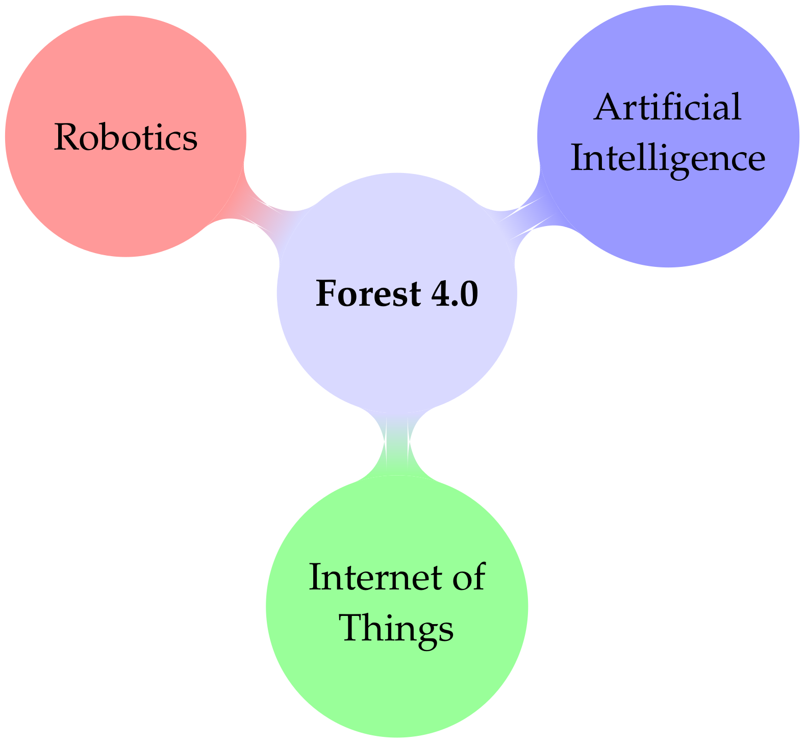
To overcome the aforementioned challenges and improve the execution of the various forestry tasks, the concept of Forest 4.0 emerges, as shown in Figure 1.

Figure 1. Forest 4.0 composition model.
As shown in Figure 1, the Forest 4.0 concept is similar to the Smart Cities concept [7][8]. Forest 4.0 has gained prominence with the use of robotic systems and electronic devices in forestry tasks such as environmental monitoring, fire prevention, inventory, planting, pruning and harvesting [9].
2. Robotic Applications in Forest
2.1. Robotic Applications for Environmental Preservation and Monitoring of Forests
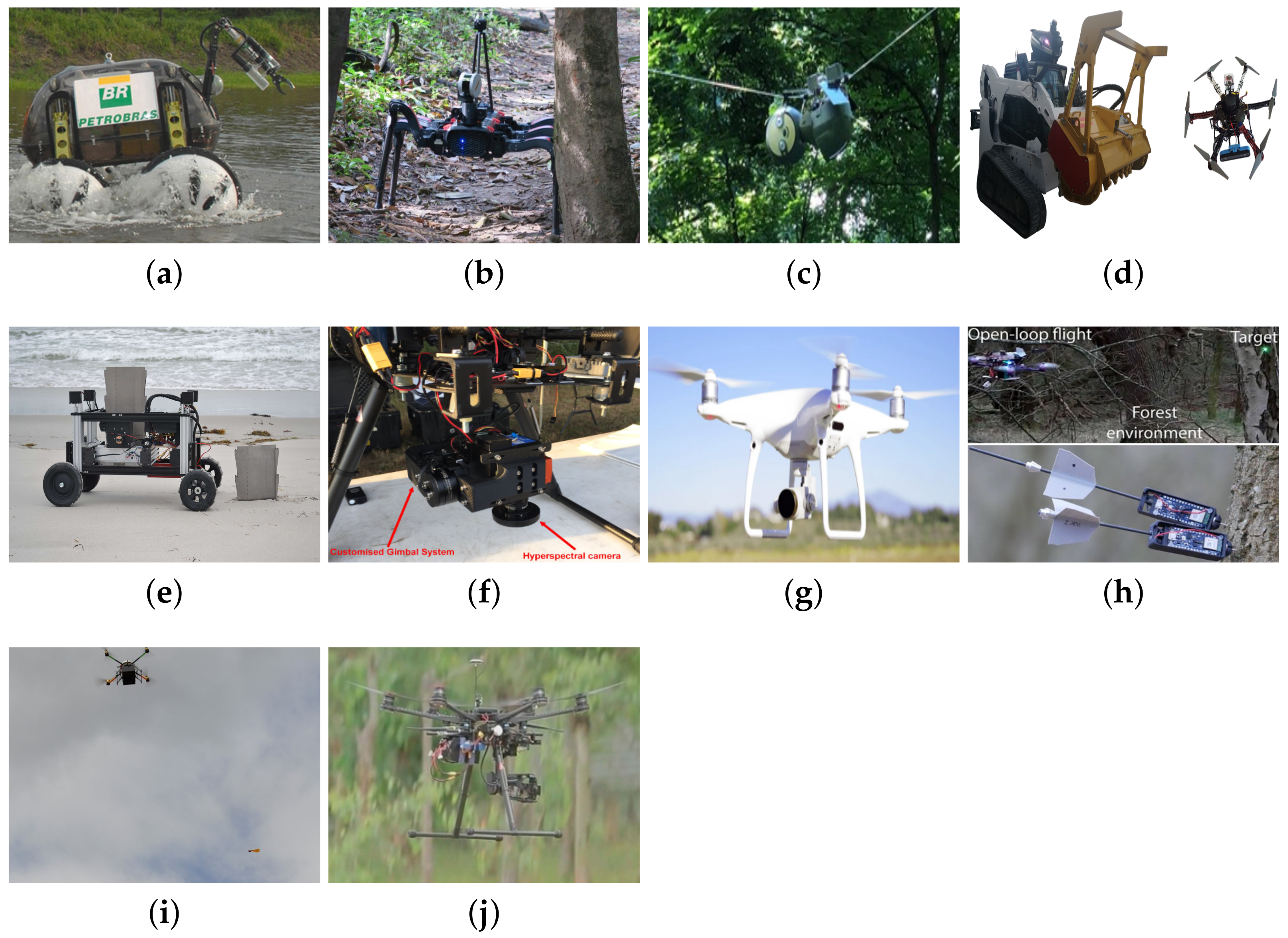
Designed to operate in the interior of the Amazon, the Environmental Hybrid Robot (EHR) Chico Mendes is a remotely operated vehicle developed to carry out monitoring missions for the Brazilian Oil Company Petrobras S.A. between the cities of Coari and Manaus, that is, about 400 km of gas pipeline along the forest. Chico Mendes is a wheel-legged amphibious robot with active reconfiguration, capable of walking on gas pipelines, land, water, swamps and sand, as shown in Figure 2a. To control the robot’s distance from the ground along with its orientation, the distance to the ground along with its gradient stability margin and traction indices, the robot has an optimal multi-objective control approach. With this approach, the robot increased the maximum tilt angle from 35°∘to 44.8°, an improvement of 28%. The robot also has a robotic arm with sensors for water quality and gas, Red, Green and Blue (RGB) camera and sampling support located on the final actuator, to monitor possible gas leaks and water pollution, in addition to checking out dengue outbreaks [10][11].

Figure 2. Examples of robotic applications used for environmental preservation and monitoring tasks in forests: (a) Chico Mendes [10], (b) Legged robot [12], (c) SlothBot [13], (d) Ranger and Scout [14], (e) Romu [15], (f) Unmanned Aerial Vehicle (UAV) robot 1 [16], (g) UAV robot 2 [17], (h) UAV robot 3 [18], (i) UAV robot 4 [19] and (j) UAV robot 5 [20].
2.2. Robotic Applications for Wildfire Fighting
Unlike the monitoring of forest activities, wildfire fighting activities require direct intervention (traditionally through firefighting trucks and planes) in the forest environment so that there is a minimum of damage not only to the fauna and flora but also to the populations that live in such locations. Although forest monitoring via satellites is of paramount importance in the fight against illegal deforestation, when there are forest fires they do not contribute to the extinction of the fire. In this case, this function is entirely dependent on the replenishment of several teams of firefighters, water trucks and firefighters aircraft. The robotic applications for wildfire fighting can contribute to faster, safer and more efficient action of spraying water or retarding agents in forest regions. The design of firefighting robots has requirements such as having a mechanical structure resistant to high temperatures and concentrations of gases and dust, high payload capacity and a locomotion system designed to transport large payloads through rough terrain and be used for multitasking.
A Six-Wheel Drive (6WD) autonomous ground vehicle, developed by military product manufacturer Lockheed Martin, was adapted to perform firefighting operations. The Fire Ox robot can be integrated with an existing infrastructure or used individually, as it has a tank with a capacity of 250 gallons and an electrical generator of up to 1000 W. This robot can be operated using a remote control and RGB and Infrared (IR) cameras [21].
Another company in the military sector, Milrem Robotics, has developed two versions of robots to firefighting operations, one to extinguish the fire and the other to assist in the transportation of hoses in hostile and difficult to access environments. Figure 3a exhibits the Multiscope Rescue with Hydra, a firefighting robot equipped with a modular foam and/or water monitor with a flow rate of 3000 L/min, which can rotate 360°∘and disperse liquids (foam and/or water) at a distance up to 62 m [22]. The robot has two sprinklers located on its front that serve as a protection system. To increase the system autonomy, the robot is powered in a hybrid way (diesel engine and battery pack) reaching a maximum autonomy of 12 h.

Figure 3. Examples of robotic applications used for wildfire fighting: (a) Multiscope Rescue with Hydra [22], (b) Multiscope Rescue Hose Cartridge [23] and (c) Colossus [24].
2.3. Robotic Applications in Forest for Inventory Operations
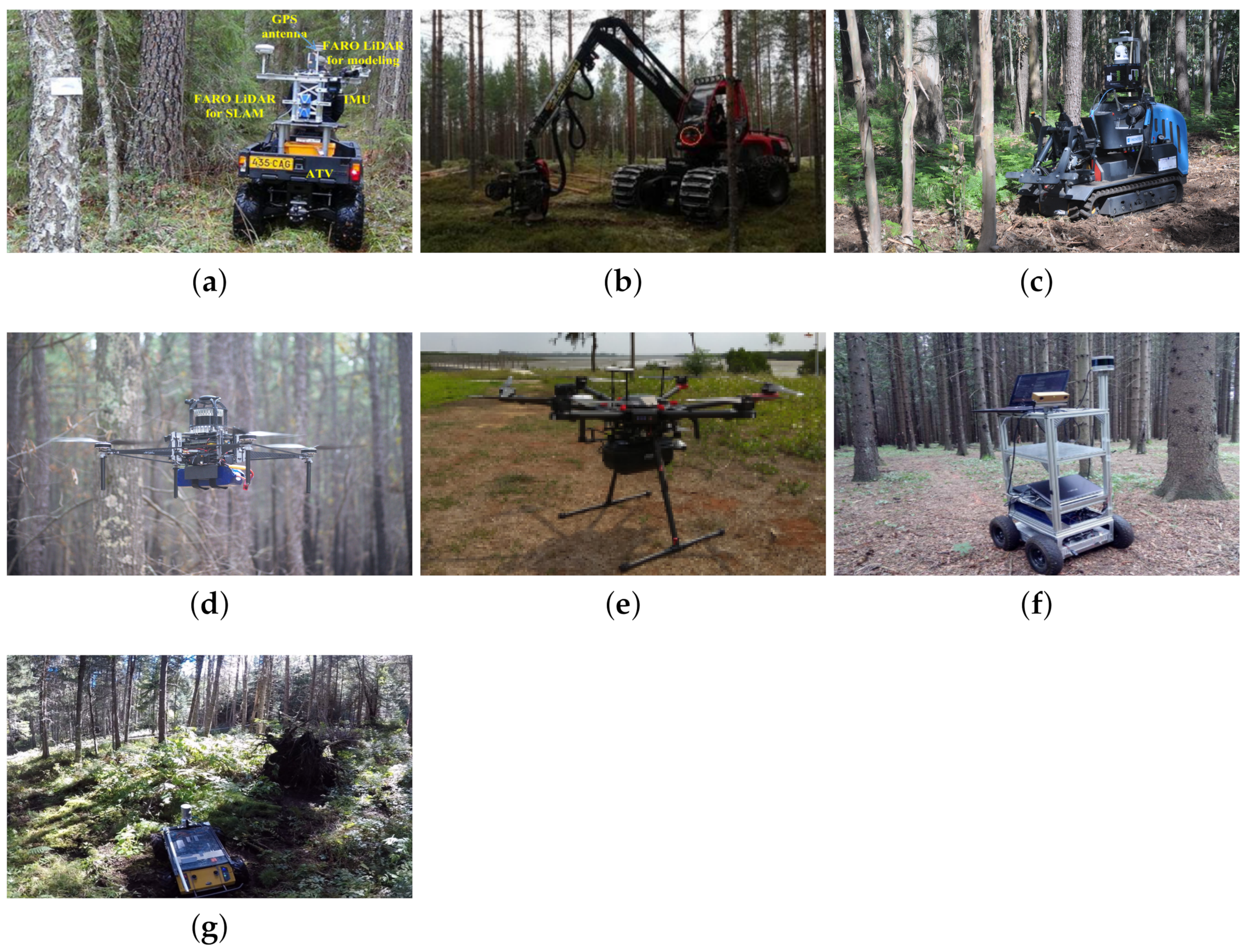
A group of researchers assessed the performance of SLAM-aided stem mapping for forest inventory with a small-footprint mobile LiDAR. Using the FGI ROAMER R2 vehicle (Figure 4a) moving at 4 km/h, between open and dense forest regions, they compared three forms of navigation: only by Global Navigation Satellite System (GNSS), using GNSS + IMU and adopting SLAM + IMU. The proposed SLAM algorithm was the Improved Maximum Likelihood Estimation (IMLE). For the open forest regions, the SLAM algorithm was shown not to be feasible, as in this region there are few detection characteristics available and the GNSS signals have greater availability. On the other hand, in regions of dense forest, the precision of the SLAM + IMU technique was 38% higher than the use of GNSS + IMU [25].

Figure 4. Examples of robotic applications used in forests for inventory operations: (a) FGI ROAMER R2 [25], (b) Komatsu Forest 931.1 [9], (c) AgRob V18 [26], (d) Forest robot 1 [27], (e) Forest robot 2 [28], (f) Superdroid [29] and (g) Husky A200 [30].
2.4. Robotic Applications in Forest for Planting, Pruning and Harvesting
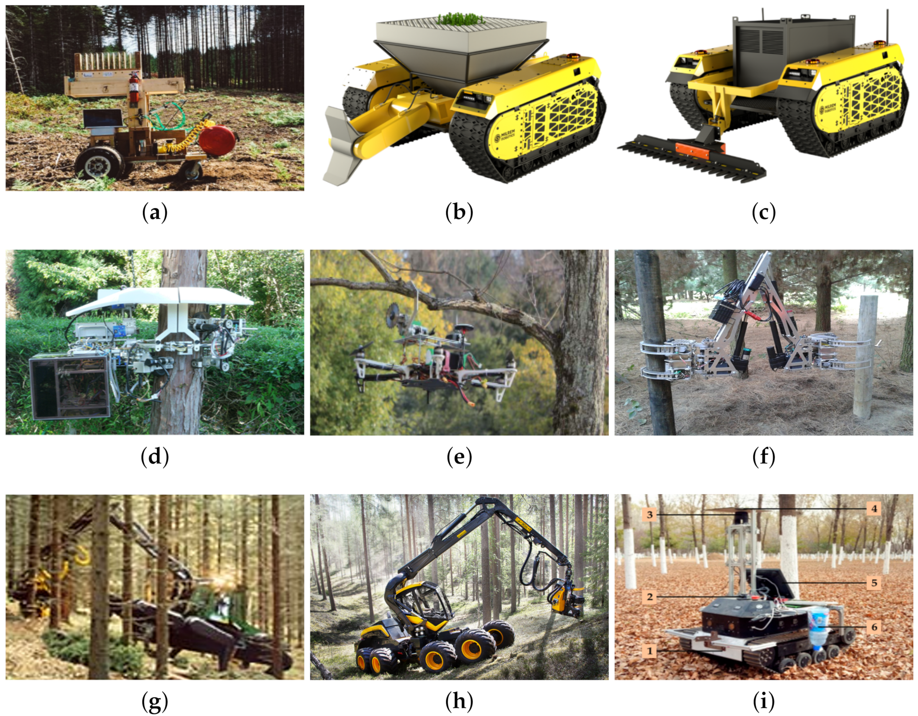
To develop technological solutions that positively impact the environment, Birch and Rhodes [31] developed the TreeRover tree planter prototype, as depicted in Figure 5a. Guided by a GNSS system, the 4WD robot is capable of planting up to 10 tree seedlings. It has an exclusive system that pierces the earth, deposits the seedling with a compressed air system and finally covers the hole by pressing the local terrain [31].

Figure 5. Examples of robotic applications used in forests for planting, pruning and harvesting tasks: (a) TreeRover [31], (b) Multiscope Forester Planter [32], (c) Multiscope Forester Brushcutter [33], (d) Pruning robot 1 [34], (e) Pruning robot 2 [35], (f) Pruning robot 3 [36], (g) Walking harvester [37], (h) Harvester CTL [38] and (i) Harvesting robot [39].
3. Conclusions
The main characteristics observed were: (a) the locomotion system is directly affected by the type of environmental monitoring to be performed; (b) different reasons for pruning result in different locomotion and cutting systems; (c) each type of forest (tropical or temperate), in each season and each type of soil can directly interfere with the navigation technique used; and (d) the integration of the concept of swarm of robots with robots of different types of locomotion systems (land, air or sea) can compensate for the time of executing tasks in unstructured environments. Two major areas are proposed for future research works: IoT-based smart forest and navigation systems. In addition, due to the existence of few studies developed in tropical forest areas, it is proposed to develop future research works in tropical regions, such as those found in Latin America and on the African and Oceania continents. Therefore, it is expected that, with the various characteristics exposed, the current robotic forest systems are improved, so that forest exploitation becomes more efficient and sustainable.
References
- FAO. The State of the World’s Forests 2020. Forests, Biodiversity and People; FAO: Rome, Italy, 2020; p. 214.
- FAO. The State of the World’s Forests 2018. Forest Pathways to Sustainable Development; FAO: Rome, Italy, 2018; p. 139.
- Paiva, P.F.P.R.; Ruivo, M.d.L.P.; Júnior, O.M.d.S.; Maciel, M.d.N.M.; Braga, T.G.M.; de Andrade, M.M.N.; dos Santos Junior, P.C.; da Rocha, E.S.; de Freitas, T.P.M.; Leite, T.V.d.S.; et al. Deforestation in protect areas in the Amazon: A threat to biodiversity. Biodivers. Conserv. 2020, 29, 19–38.
- Boer, M.M.; Dios, V.R.; Bradstock, R.A. Unprecedented burn area of Australian mega forest fires. Nat. Clim. Chang. 2020, 10, 171–172.
- Spaniol, R.L.; Mendonça, M.d.S.; Hartz, S.M.; Iserhard, C.A.; Stevens, M. Discolouring the Amazon Rainforest: How deforestation is affecting butterfly coloration. Biodivers. Conserv. 2020, 29, 2821–2838.
- CRED. Economic, Losses, Poverty & Disasters: 1998–2017; CRED: Bengaluru, India, 2018; p. 33.
- Oliveira, L.F.P.; Manera, L.T.; Luz, P.D.G. Smart Traffic Light Controller System. In Proceedings of the 2019 Sixth International Conference on Internet of Things: Systems, Management and Security (IOTSMS), Granada, Spain, 22–25 October 2019; pp. 155–160.
- Oliveira, L.F.P.; Manera, L.T.; Luz, P.D.G. Development of a Smart Traffic Light Control System with Real-Time Monitoring. IEEE Internet Things J. 2020, 8, 3384–3393.
- Li, Q.; Nevalainen, P.; Queralta, J.P.; Heikkonen, J.; Westerlund, T. Localization in Unstructured Environments: Towards Autonomous Robots in Forests with Delaunay Triangulation. Remote Sens. 2020, 12, 1870.
- Freitas, G.; Gleizer, G.; Lizarralde, F.; Hsu, L.; Reis, N.R.S. Kinematic reconfigurability control for an environmental mobile robot operating in the Amazon rain forest. J. Field Robot. 2010, 27, 197–216.
- Reis, N.R.S. Desenvolvimento de tecnologias como conjunto de ferramentas e suporte às atividades e pesquisas socioambientais na Amazônia brasileira: Mobilidade e acessibilidade em áreas de várzea. Master’s Thesis, Universidade Federal do Amazonas, Manaus, Amazonas, Brazil, 2010.
- CSIRO. Amazon 360: Testing Self-Navigation in a Novel Landscape. 2020. Available online: (accessed on 8 March 2021).
- Notomista, G.; Emam, Y.; Egerstedt, M. The SlothBot: A Novel Design for a Wire-Traversing Robot. IEEE Robot. Autom. Lett. 2019, 4, 1993–1998.
- Couceiro, M.S.; Portugal, D.; Ferreira, J.F.; Rocha, R.P. SEMFIRE: Towards a new generation of forestry maintenance multi-robot systems. In Proceedings of the 2019 IEEE/SICE International Symposium on System Integration (SII), Paris, France, 14–16 January 2019; pp. 270–276.
- Melenbrink, N.; Werfel, J. Autonomous Sheet Pile Driving Robots for Soil Stabilization. In Proceedings of the 2019 International Conference on Robotics and Automation (ICRA), Montreal, QC, Canada, 20–24 May 2019; pp. 339–345.
- Sandino, J.; Pegg, G.; Gonzalez, F.; Smith, G. Aerial Mapping of Forests Affected by Pathogens Using UAVs, Hyperspectral Sensors, and Artificial Intelligence. Sensors 2018, 18, 944.
- Fujimoto, A.; Haga, C.; Matsui, T.; Machimura, T.; Hayashi, K.; Sugita, S.; Takagi, H. An End to End Process Development for UAV-SfM Based Forest Monitoring: Individual Tree Detection, Species Classification and Carbon Dynamics Simulation. Forests 2019, 10, 680.
- Farinha, A.; Zufferey, R.; Zheng, P.; Armanini, S.F.; Kovac, M. Unmanned Aerial Sensor Placement for Cluttered Environments. IEEE Robot. Autom. Lett. 2020, 5, 6623–6630.
- Pounds, P.; Singh, S. Samara: Biologically Inspired Self-Deploying Sensor Networks. IEEE Potentials 2015, 34, 10–14.
- Gonzalez, L.F.; Montes, G.A.; Puig, E.; Johnson, S.; Mengersen, K.; Gaston, K.J. Unmanned Aerial Vehicles (UAVs) and Artificial Intelligence Revolutionizing Wildlife Monitoring and Conservation. Sensors 2016, 16, 97.
- Apparatus, F. Firefighting Robotic Vehicle System. 2020. Available online: (accessed on 9 March 2021).
- Milrem Robotics. Multiscope Rescue with Hydra. 2020. Available online: (accessed on 9 March 2021).
- Milrem Robotics. Multiscope Rescue Hose Cartridge. 2020. Available online: (accessed on 9 March 2021).
- Shark Robotics. Colossus. 2020. Available online: (accessed on 10 March 2021).
- Tang, J.; Chen, Y.; Kukko, A.; Kaartinen, H.; Jaakkola, A.; Khoramshahi, E.; Hakala, T.; Hyyppä, J.; Holopainen, M.; Hyyppä, H. SLAM-Aided Stem Mapping for Forest Inventory with Small-Footprint Mobile LiDAR. Forests 2015, 6, 4588–4606.
- Reis, R.; Santos, F.N.S.; Santos, L. Forest Robot and Datasets for Biomass Collection. In Robot 2019: Fourth Iberian Robotics Conference; Springer: Berlin/Heidelberg, Germany, 2020; pp. 152–163.
- Chen, S.W.; Nardari, G.V.; Lee, E.S.; Qu, C.; Liu, X.; Romero, R.A.F.; Kumar, V. SLOAM: Semantic Lidar Odometry and Mapping for Forest Inventory. IEEE Robot. Autom. Lett. 2020, 5, 612–619.
- Wang, D.; Wan, B.; Liu, J.; Su, Y.; Guo, Q.; Qiu, P.; Wu, X. Estimating aboveground biomass of the mangrove forests on northeast Hainan Island in China using an upscaling method from field plots, UAV-LiDAR data and Sentinel-2 imagery. Int. J. Appl. Earth Obs. Geoinf. 2020, 85, 101986.
- Pierzchała, M.; Giguère, P.; Astrup, R. Mapping forests using an unmanned ground vehicle with 3D LiDAR and graph-SLAM. Comput. Electron. Agric. 2018, 145, 217–225.
- Tremblay, J.F.; Béland, M.; Gagnon, R.; Pomerleau, F.; Giguère, P. Automatic three-dimensional mapping for tree diameter measurements in inventory operations. J. Field Robot. 2020, 37, 1328–1346.
- Birch, N.; Rhodes, T. Engineering co-op Students Build Tree-Planting Robot to Help Fight Deforestation. 2016. Available online: (accessed on 11 March 2021).
- Milrem Robotics. Multiscope Forester Planter. 2020. Available online: (accessed on 11 March 2021).
- Milrem Robotics. Multiscope Forester Brushcutter. 2020. Available online: (accessed on 11 March 2021).
- Ishigure, Y.; Hirai, K.; Kawasaki, H. A pruning robot with a power-saving chainsaw drive. In Proceedings of the 2013 IEEE International Conference on Mechatronics and Automation, Takamatsu, Japan, 4–7 August 2013; pp. 1223–1228.
- Molina, J.; Hirai, S. Aerial pruning mechanism, initial real environment test. Robot. Biomim. 2017, 4, 15.
- Meaclem, C.V.; Shao, L.; Parker, R.; Gutschmidt, S.; Hann, C.E.; Milne, B.J.E.; Chen, X. Sensor guided biped felling machine for steep terrain harvesting. In Proceedings of the 2014 IEEE International Conference on Automation Science and Engineering (CASE), New Taipei, Taiwan, 18–22 August 2014; pp. 984–989.
- Billingsley, J.; Visala, A.; Dunn, M. Robotics in Agriculture and Forestry. In Springer Handbook of Robotics; Springer Berlin Heidelberg: Berlin/Heidelberg, Germany, 2008; pp. 1065–1077.
- Ponsse. The Cut-To-Length Method. 2020. Available online: (accessed on 12 March 2021).
- Zhang, C.; Yong, L.; Chen, Y.; Zhang, S.; Ge, L.; Wang, S.; Li, W. A Rubber-Tapping Robot Forest Navigation and Information Collection System Based on 2D LiDAR and a Gyroscope. Sensors 2019, 19, 2136.


