 +1 credit
| Version | Summary | Created by | Modification | Content Size | Created at | Operation |
|---|---|---|---|---|---|---|
| 1 | Anchita Anchita | + 654 word(s) | 654 | 2020-03-16 03:44:09 | | | |
| 2 | Nicole Yin | -11 word(s) | 643 | 2020-10-28 02:57:34 | | |
Video Upload Options
Saltwater lakes around the world are drying at a rapid rate. These lakes are present in arid and semi-arid regions where evaporation exceeds precipitation. The Aral Sea and Lake Urmia are examples for such rapidly drying lakes. These two lakes have lost up to 90% of their former area in the past 50 years.
1. Lake Urmia Basin
The Lake Urmia Basin (LUB) which encloses Lake Urmia is located in northeast Iran (37°41'59.99" N, 45°18'60" E). The lake basin is shared between the provinces of West Azerbaijan, East Azerbaijan, and Kurdistan as shown in Figure 1. LUB has a total area of 51,331 km2 of which 4750–6100 km2 was occupied by Lake Urmia. Lake Urmia was the twentieth largest lake and second-largest hypersaline lake in the world [1]. The total volume of the lake was 25–27 km3. It had a maximum depth of 16 m and an average depth of 6 m. It was fed by 60 rivers of which Zarrieh Rud and Simineh Rud contribute the highest flow to the lake [2][3][4]. The lake originally contained 102 islands that used to attract migratory birds. Lake Urmia was declared as a National Park and a UNESCO Biosphere Reserve. There were five Ramsar sites in the basin—Lake Urmia and four satellite wetlands—and nine globally important bird areas. The lake is the main habitat for the endemic Iranian brine shrimp, Artemia urmiana, and is a protected aquatic environment [5].
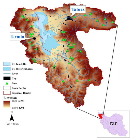
Figure 1. Geographical representation of Lake Urmia Basin [6].
2. Aral Sea Basin
The Aral Sea Basin (ASB) which encompasses the Aral Sea, is shared between five countries: Kazakhstan, Kyrgyzstan, Tajikistan, Turkmenistan, and Uzbekistan. The ASB is mainly fed by two main tributaries: the Amu Darya from the South and Syr Darya from the East, as shown in Figure 2 [7].
The Aral Sea was once the fourth largest lake in the world and the largest saline endorheic lake in Central Asia. The total area of the Aral Sea in 1960 was 68,478 km2 with a water capacity of 1093 km3. Since then it has drastically reduced due to diminishing water inflow [8]. The water level decreased from 53.40 m to 41.02 m during the period 1960–1986 [8]. In 1986, the Kokaral Desert was formed which divided the Aral Sea into two separate lakes; the North Aral Sea (NAS) and South Aral Sea (SAS) [9].
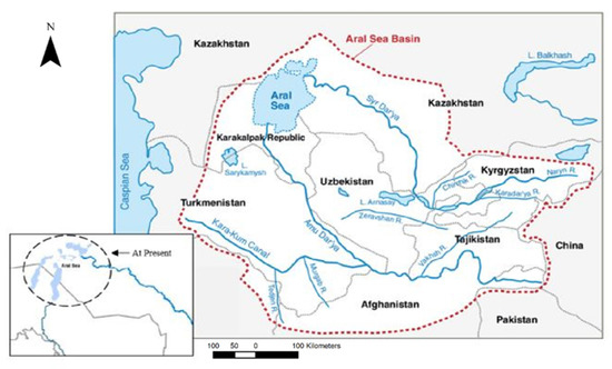
Figure 2. Geographical representation of the Aral Sea Basin. Blue lines indicate tributaries of the Amu Darya and Syr Darya. Red dotted lines indicate the Aral Sea Basin. (Source: modified from [10][11]).
The North Aral Sea belongs to Kazakhstan (46°48' N, 61°40' E) and had a surface area of 5992 km2, with a water volume of 80 km3, a maximum depth of 29 m, and an average depth of 13.3 m. It is fed by the Syr Darya river which is the confluence of Naryn and Kara-Darya rivers in the Feraghan Valley. It is the second-longest river in Central Asia and reaches the NAS after travelling 2212 km. Along this course, Syr Darya receives water from seven rivers, namely the Ohangaron and Chirchiq in Uzbekistan, and the Arys, Badam, Boroldai, Bungun, and Keles in Kazakhstan [7].
The South Aral Sea belongs to Uzbekistan (45°00' N, 60°00' E) and had a surface area of 60,000 km2, with a water volume of 984 km3. The SAS was formerly fed by the Amu Darya tributary, which is the confluence of the Pyanj and Vaksh rivers. It is the longest river in Central Asia and used to travel 2550 km from its source until it reaches the SAS. Along this course, Amu Darya receives water from four rivers, namely Kunduz (Afghanistan), Kafirnigan (Tajikistan), Sherabad (Uzbekistan), and Surkhandarya (Uzbekistan). The SAS has further split into the East and West Aral Seas with a surface area of 46,466 km2 and 13,628 km2, respectively. The East Aral Sea was shallow with a maximum depth of 28 m and an average depth of 14.7 m, while the West Aral Sea was deeper with a maximum depth of 69 m and an average depth of 22.2 m [7].
References
- A. H. Delju; A. Ceylan; E. Piguet; Martine Rebetez; Observed climate variability and change in Urmia Lake Basin, Iran. Meteorology and Atmospheric Physics 2012, 111, 285-296, 10.1007/s00704-012-0651-9.
- Yazdandoost, F.; Khorami, N. Integrated Sediment Transport Modelling for Rivers Feeding Lakes and Wetlands. In Proceedings of River Sedimentation: Proceedings of the 13th International Symposium on River Sedimentation (Stuttgart, Germany, 19-22 September 2016); p. 112.
- Arash Emdadi; Petros Gikas; Maria Farazaki; Yunus Emami; Salinity gradient energy potential at the hyper saline Urmia Lake – ZarrinehRud River system in Iran. Renewable Energy 2016, 86, 154-162, 10.1016/j.renene.2015.08.015.
- Chaudhari, S. Modeling and Remote Sensing of Water Storage Change in Lake Urmia Basin, Iran. Michigan State University, 2017.
- Abdolreza Karbassi; Gholamreza Nabi Bidhendi; Amirhossein Pejman; Mehdi Esmaeili Bidhendi; Environmental impacts of desalination on the ecology of Lake Urmia. Journal of Great Lakes Research 2010, 36, 419-424, 10.1016/j.jglr.2010.06.004.
- Vaheddoost, B.; Aksoy, H. Evaluation of Base Flow Index in Lake Urmia Basin Using One Parameter Digital Filter Method. In Proceedings of NCIID-The 1st International and 4th National Congress on Iranian Irrigation and Drainage, Urmia University, Iran, 13-14 November 2019.
- Philip Micklin; Introduction to the Aral Sea and Its Region. The Aral Sea 2013, 10178, 15-40, 10.1007/978-3-642-02356-9_2.
- CAWaterInfo. Aral Data. Available online: http://www.cawaterinfo.net/aral/data/morpho_e.htm (accessed on 11 October 2019).
- Siegmar-W. Breckle; G. V. Geldyeva; Dynamics of the Aral Sea in Geological and Historical Times. Forest-Water Interactions 2011, 218, 13-35, 10.1007/978-3-642-21117-1_2.
- Philip Micklin; The Aral Sea Disaster. Annual Review of Earth and Planetary Sciences 2007, 35, 47-72, 10.1146/annurev.earth.35.031306.140120.
- Kai Wegerich; Daniel Van Rooijen; Ilkhom Soliev; Nozilakhon Mukhamedova; Water Security in the Syr Darya Basin. Water 2015, 7, 4657-4684, 10.3390/w7094657


