Your browser does not fully support modern features. Please upgrade for a smoother experience.
Submitted Successfully!
 +1 credit
Thank you for your contribution! You can also upload a video entry or images related to this topic.
For video creation, please contact our Academic Video Service.
| Version | Summary | Created by | Modification | Content Size | Created at | Operation |
|---|---|---|---|---|---|---|
| 1 | Masoud Samaei | -- | 2381 | 2024-02-06 03:06:41 | | | |
| 2 | Peter Tang | Meta information modification | 2381 | 2024-02-06 03:47:48 | | |
Video Upload Options
We provide professional Academic Video Service to translate complex research into visually appealing presentations. Would you like to try it?
Cite
If you have any further questions, please contact Encyclopedia Editorial Office.
Samaei, M.; Stothard, P.; Shirani Faradonbeh, R.; Topal, E.; Jang, H. Unmanned Aerial Vehicles in Mine Closure/Rehabilitation Projects. Encyclopedia. Available online: https://encyclopedia.pub/entry/54786 (accessed on 24 June 2026).
Samaei M, Stothard P, Shirani Faradonbeh R, Topal E, Jang H. Unmanned Aerial Vehicles in Mine Closure/Rehabilitation Projects. Encyclopedia. Available at: https://encyclopedia.pub/entry/54786. Accessed June 24, 2026.
Samaei, Masoud, Phillip Stothard, Roohollah Shirani Faradonbeh, Erkan Topal, Hyongdoo Jang. "Unmanned Aerial Vehicles in Mine Closure/Rehabilitation Projects" Encyclopedia, https://encyclopedia.pub/entry/54786 (accessed June 24, 2026).
Samaei, M., Stothard, P., Shirani Faradonbeh, R., Topal, E., & Jang, H. (2024, February 06). Unmanned Aerial Vehicles in Mine Closure/Rehabilitation Projects. In Encyclopedia. https://encyclopedia.pub/entry/54786
Samaei, Masoud, et al. "Unmanned Aerial Vehicles in Mine Closure/Rehabilitation Projects." Encyclopedia. Web. 06 February, 2024.
Copy Citation
Unmanned aerial vehicles (UAVs) are being used more frequently nowadays because of advancements in sensor and control technologies. They can use a range of single-band, multispectral, and hyperspectral sensors, including those that function in visible, infrared, and microwave spectrums. Their application in heritage and archaeological site mapping, transportation, civil engineering, agriculture, landscape mapping, wildlife conservation, infrastructure inspection, and search and rescue have been investigated in several studies.
mine closure
rehabilitation
UAVs
sensors
mixed reality
artificial intelligence
1. Introduction
Mine site closure and abandonment are becoming more severe and profound challenges for most stakeholders worldwide. Due to the substantial disruption caused by mining, post-mine closure differs significantly from non-mining restoration programs [1][2]. In this regard, closure is defined as restoring damaged sites to their initial states of productivity and self-sufficiency while recognising the site’s and the area’s beneficial uses [3]. Restoration aims to create a self-sufficient ecosystem that can sustain itself without outside intervention [4]. Numerous countries have enacted legislation mandating mining companies adhere to strict criteria for restored topsoil, vegetation, and water quality following mine rehabilitation [5]. To accomplish these tasks, comprehensive management is required. However, management is impossible without monitoring and measurement. Monitoring and measuring the progress of a mine closure program is one of the critical challenges for all stakeholders engaged in the project [6]. The type of information needed changes as the closure area develops, and stakeholders should be aware that the system is moving toward a stable, sustainable state and that its constituent parts are evolving correctly [6]. Scholars have reported [7][8] that within the life of a mine (LoM), especially in its closure and rehabilitation phases, keeping track of updates, progressively planning and managing operations, determining and managing risks, and achieving a social licence to operate are significant challenges for mining companies [7][8]. Hence, for the mining, administrative, and consulting sectors, having monitoring and interpreting tools that offer information on many of the difficulties encountered during mine closure would be invaluable [9]. Given the complexity of the systems being controlled, Tongway and Ludwig [9] refer to an integrated monitoring approach as a “toolbox” that employs several monitoring techniques during the project. This “toolbox” of methods can be used to demonstrate the evidence of achieving a predetermined completion requirement. Currently, neither regulators nor operators have an integrated software package to manage and continuously regulate crucial inputs and the process of generating a mine closure framework.
In recent decades, several data collection techniques have been introduced by researchers. For acquiring precise terrain surfaces, survey methods like the Real-Time Kinematic Global Positioning System (RTK-GPS) and electronic distance measuring (Total Station) are frequently used [10]. However, because of the size of the field of interest, the time-consuming nature of terrestrial surveying, the risks associated with direct monitoring, and the difficulty of accessing some areas, terrestrial surveying is usually not an appropriate data collection method. Typically, three remote sensing methods—satellites, human-crewed aircraft, and unmanned aerial vehicles (UAVs)—can capture high-resolution photographs of vast areas [11]. Satellites may be constrained by insufficient spatial resolution, cloud cover, the running cycle, and the height of an orbit. Piloted planes may be constrained by airspace restrictions, sun angle and weather [12]. UAV-based remote sensing systems feature both common airborne characteristics and distinctive characteristics. The technology could well be utilised in high-risk regions or on windy days and can be swiftly and routinely operated. Despite this, the system’s limited coverage area results from its short battery life. UAVs can also operate close to their intended targets while collecting high-quality photos [13]. Therefore, UAV remote sensing is a versatile and effective method of getting high-resolution photographs. It offers precise information from low altitudes and is less expensive than satellites and human-crewed aircraft [14].
UAVs are being used more frequently nowadays because of advancements in sensor and control technologies. They can use a range of single-band, multispectral, and hyperspectral sensors, including those that function in visible, infrared, and microwave spectrums [15]. Their application in heritage and archaeological site mapping [16], transportation [17], civil engineering [18], agriculture [19], landscape mapping [20], wildlife conservation [21], infrastructure inspection [22], and search and rescue [23] have been investigated in several studies. According to McKenna, et al. [5], who conducted a study on the use of remote sensing in mine rehabilitation over more than 50 years, drones have become increasingly popular in recent years. The study found that although 50% of the studies used data from Landsat sensors throughout the 50-year period, other types of sensors became more prevalent over time, particularly between 2010 and 2019. In fact, during the years 2017–2019, drones were used in 25% of the studies, while aerial hyperspectral, aerial optical, high-resolution earth observation Satellite Pour l’Observation de la Terre (SPOT), and WorldView were used in 8%, 4%, 5%, and 3% of the studies, respectively.
2. Application of UAVs in Mine Closure/Rehabilitation Projects
UAVs are used in mining to map sites, inspect the equipment, and gather data [24]. This information is useful in planning mining operations and monitoring environmental impacts. UAVs enable the faster and more efficient maintenance and repair of equipment [25][26][27]. Studies also aim to quantify mineral resources and characterise geomorphic properties [28][29]. Therefore, as seen in Figure 1, the applications of UAVs in the mining industry can be categorised into four groups: Exploration, Exploitation, Reclamation, and Miscellaneous. Figure 1 illustrates the present and possible uses in each category.
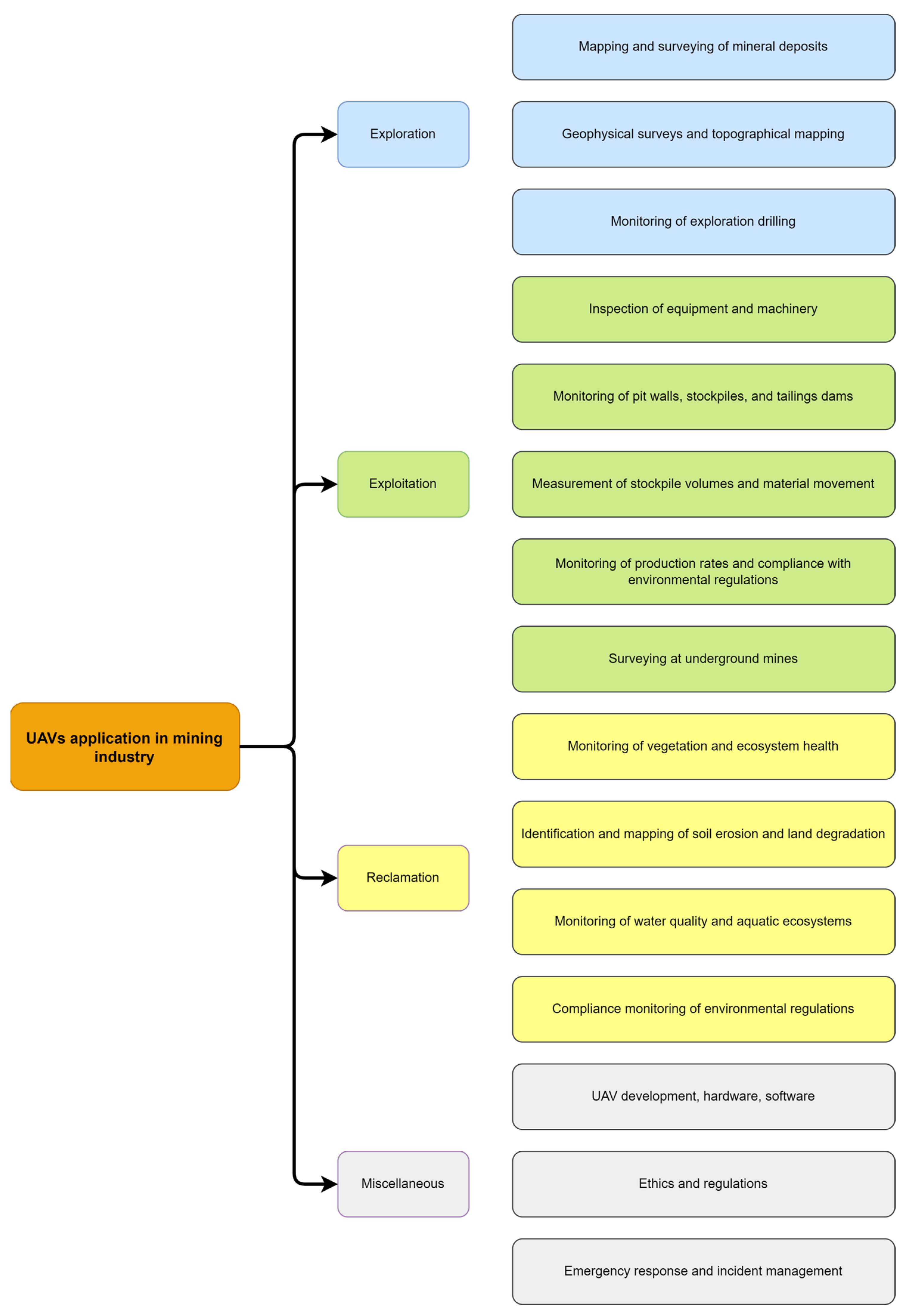
Figure 1. The present and potential utilisation of UAVs in the mining industry.
Mine rehabilitation monitoring is a new branch of remote sensing applications in the mining industry. As stated by Padró, et al. [30], UAV imagery was not used specifically for monitoring opencast mine restorations in a “standardised” way before 2019. However, some studies in recent years tried to fill the gaps and establish a foundation for more comprehensive studies [30][31][32][33]. Some studies tried to extract the changes in the ground surface by the differentiation of extraction and collection sites in exploited areas [34][35]. Xiang, et al. [34] evaluated the geomorphic changes associated with mining in northeast Beijing. Digital elevation models (DEMs) were generated from high-resolution photos collected with a UAV in 2014 and 2016. A geomorphic change assessment was conducted using two methodologies. As a first step, the differences between the two DEMs were quantitatively estimated on a cell-by-cell basis to determine the detectable area, volumetric changes, and the mined tonnage. The volumetric changes in these accumulation areas primarily represent the increase in tailings over the two years that were taken into consideration.
In addition, the slope local length of autocorrelation (SLLAC) was used to retrieve the extent of the open pit using an empirical model to determine the surface covered by open-pit mining. Based on the DoD analysis, real changes and volumetric changes could be estimated, while the SLLAC analysis and its derived parameters (SPC, Surface Peak Curvature) have allowed for detailed depictions of terraces and open pit mine extent. Mining companies could use this information to plan production and environmental recovery carefully. By applying DoD and SLLAC, a substantial time series dataset can be derived, which might assist in planning for sustainable environmental management or minimise the effects of anthropogenic modifications caused by mining.
Padró, et al. [30] conducted a study on the restoration of a medium-sized open-pit mine (<10 ha) using a small, lightweight rotary-wing UAV equipped with sensors with a spatial resolution of 9 cm. The study used highly automated batch processes to reduce fieldwork time significantly compared to traditional inspection methods. The fieldwork involved geometric stacks maintenance, field Spectro Radiometric measurements, and UAV flight. With just two hours of ground-truth data collection and UAV flight, the restored area of 10 ha was thoroughly inspected. An operator took two working days to process the collected data. The research utilised the k-Nearest Neighbour (kNN) classification algorithm [36] to classify land cover automatically. The kNN algorithm is known for its resilience when distinct spectral responses are linked to a single informational class [37]. The study used multispectral sensors, low-cost radiometric reference panels, and a field Spectro Radiometer to produce detailed maps, including orthophoto maps, Digital Elevation Models, Digital Surface Models, vegetation indices, and thematic land cover maps. The maps were categorised into six categories—Mine waste, Topsoil, Tree cover, Shrublands, Grasslands, and Remaining shadows—and yielded an accuracy rate of over 94%.
Moudrý, et al. [38] evaluated the effectiveness of UAV-derived RGB and airborne-derived Light Detection and Ranging (LiDAR) point clouds in characterising a post-mining site. The researchers took images under two conditions, leaf-off and leaf-on. They found that point densities in photogrammetrically acquired point clouds under leaf-off conditions exceeded those acquired under leaf-on conditions, and provided complete coverage of the study area. The study also revealed that the accuracy of the digital terrain model (DTM) derived from images (UAV-based) acquired under leaf-off conditions was comparable to that of the LiDAR-derived DTM. However, the accuracy of UAV-based DTMs decreased in the following order: forest, steppes, and aquatic vegetation. Moudrý, et al. [38] suggested that leaf-off UAV imagery could be an effective and cost-efficient alternative for building DTMs for assessing risks associated with the instability of spoil bank terrain. Additionally, Moudrý, et al. [38] proposed that a combination of leaf-off and leaf-on acquisitions has the potential to replace expensive airborne LiDAR surveys for applications that require information on vegetation cover or height. Moreover, the usage of UAV imagery during both leafless and leafy seasons has the potential to enable the estimation of vegetation’s structural characteristics, which could assist in examining the susceptibility for slope collapse or determining the effectiveness of restoration efforts. Nonetheless, more investigation is necessary to quantitatively assess the images’ sensitivity and examine this technique’s possibilities [38].
To generate cartographic outputs for a quarry restoration using UAV, Carabassa, et al. [33] developed a unified process by combining various remote sensing applications. This involved using image processing techniques and terrain analysis algorithms for supervised land cover classification. They used a Scale-Invariant Feature Transform (SIFT) algorithm to create a database of singular points. The outputs included ortho imagery, Digital Surface Models (DSM), land cover maps, volume variation calculations, dust deposition and erosion identification, and drainage network evaluation maps. The land cover classification was conducted using both multispectral and visible RGB sensors, with the latter yielding the Modified Green Red Vegetation Index (MGRVI), Brightness Index (BI), and Triangular Greenness Index (TGI), while the Normalized Difference Vegetation Index (NDVI) was derived from multispectral imagery. To derive new products like vegetation, change or soil loss from erosion, time series data would be useful for comparison. Such extensive data could lead to increased monitoring and scientific interest, enabling the study of ecological and hydrological processes. Other products, such as those related to geotechnical risks or pest infestations, could be included to enhance the workflow. Adopting this approach can facilitate the large-scale monitoring of land restoration, optimise resources, promote sustainable practices, and foster collaboration among companies, environmental scientists, and public authorities.
Open-pit mining activity often results in the direct emission of particulates and gases into the atmosphere. To identify potential hazards, Nguyen, et al. [39] proposed an air quality monitoring system and spatial analysis using UAVs. They integrated gas and dust sensors into the UAV and used different spatial interpolation methods, including trilinear interpolation, nearest neighbour, and natural neighbour, to derive air concentration levels of CO, SO2, PM2.5, and CO2 in the atmosphere of open-pit coal mines (see Figure 2). The examined hazards included SO2, CO2, CO, and PM2.5. The results indicate that the UAV-based air quality monitoring system performed safely and efficiently in deep open-pit coal mines. The proposed approach was considered an additional option with simple procedures and an acceptable price to estimate the accurate 3D distribution of air quality in open-pit mines with flexibility.
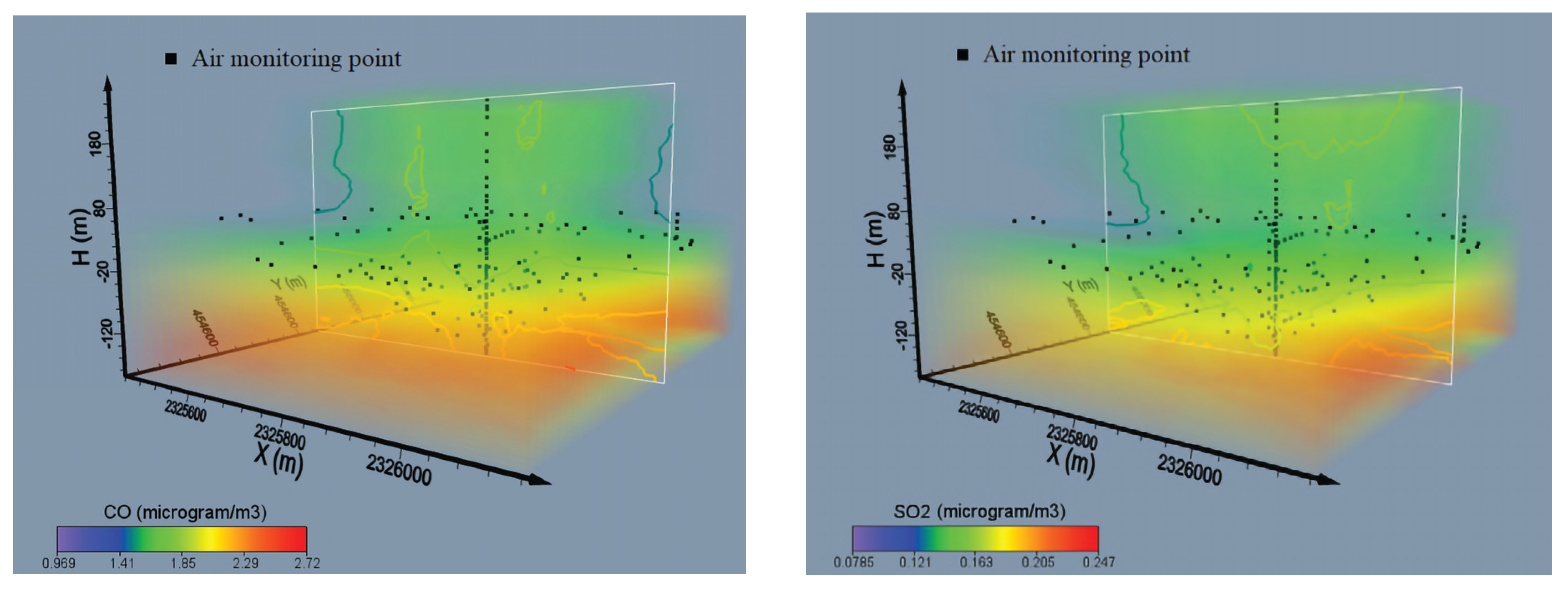
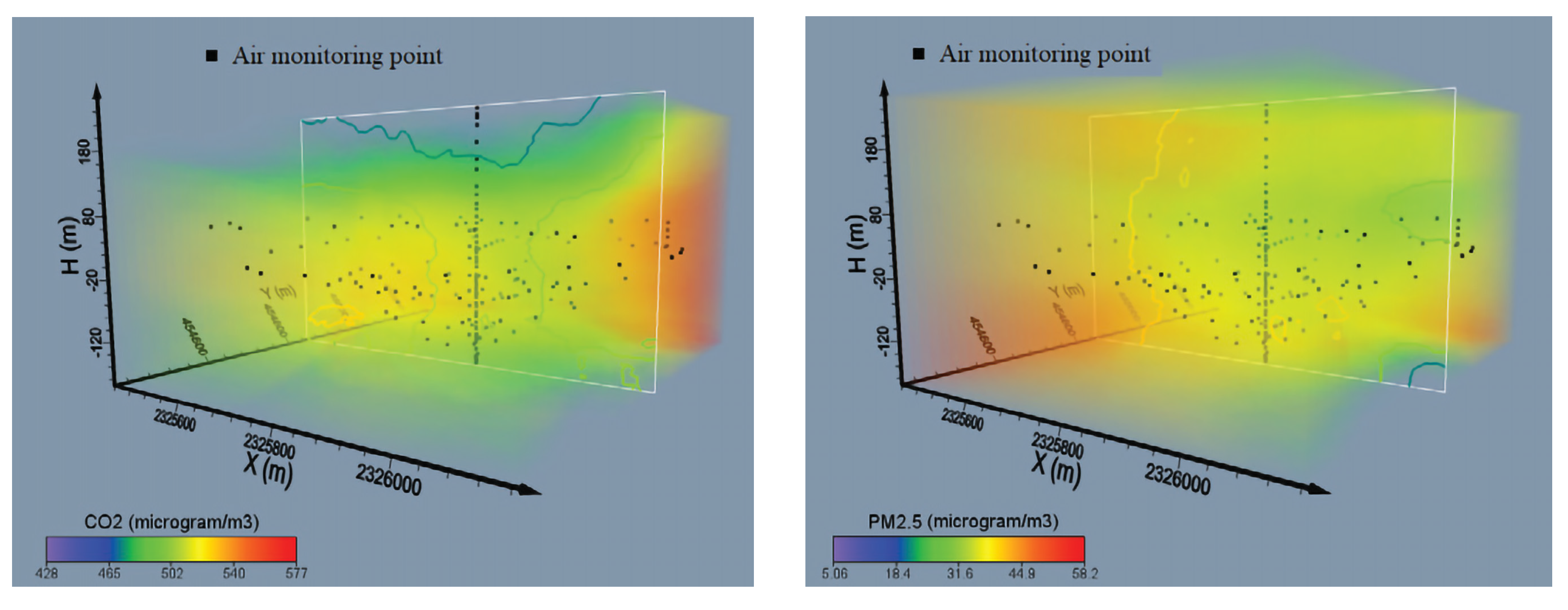
Figure 2. Contour plots and volume rendering of gases including CO, SO2, PM2.5, and CO2 [39].
Drone-acquired imagery is an important tool for the morphometric characterisation of terrains in open-pit mining, particularly for studying erosion processes in restored areas. Padró, et al. [31] have put forward a novel approach for estimating the Digital Elevation Model (DEM) in advance of the erosion process using data acquired by UAVs and Geographic Information System (GIS) techniques. Specifically, hydrologic analysis, such as channel network and watershed detection, was employed to estimate the DEMT0. The difference between the estimated DEM T0 and the current DEM T1 was calculated to obtain a DoD. The DoD was used to determine the extent of the estimated eroded area and volume of soil between T0 and T1. A case study was conducted to demonstrate the practical application of this approach. A workflow for detecting and calculating erosion was implemented, yielding valuable information for the management of quarry restoration. The approach proved to be especially effective in identifying areas with high erosion rates and corresponding soil accumulation. Additionally, the control of slope and erosion rates facilitates identifying and monitoring areas with active erosion, thereby aiding in the decision-making process for implementing stabilisation measures in highly susceptible landslide areas. Overall, the proposed method has demonstrated its suitability for mining operations and other similar geomorphological scenarios. Its successful application highlights its potential for widespread use in environmental monitoring and management, offering valuable insights into terrain characterisation and erosion processes. With the ability to accurately estimate and monitor changes in terrain, this approach provides a powerful tool for enhancing restoration efforts and promoting sustainable mining practices.
Russell, et al. [40] suggested a novel approach for determining the necessary filling material for restoration by utilising data from drones and GIS processing. However, the main contribution of the method was in extending the analysis beyond the excavation area to include the surrounding terrain in the relief restoration model. The study was conducted in Montsià, Masdenverge municipality, Tarragona province, Catalonia, located in Northeast Spain. The approach involved referencing the DEM obtained from the drone with control points taken from the official agency’s model, which improved the precision and comprehensiveness of the analysis. A digital height difference model (DHdM) was obtained by dividing the DEMs and used in volume change calculations. The method improved the accuracy of the restored relief model and provided information on the surrounding terrain. Additionally, the water flow behaviour confirmed that the modelled relief was well integrated with the environment. Users evaluated the tool, which enabled the easy and precise estimation of the required filling material for restoring the excavation pit morphology and predicting its environmental impact. Due to its high spatial resolution and accurate mathematical operations, the method provided useful criteria for decision-making in the treatment and restoration of excavation sites. Russell, et al. [40] indicated that future research should focus on incorporating additional variables to increase the effectiveness and reliability of the models.
References
- Doley, D.; Audet, P. Adopting novel ecosystems as suitable rehabilitation alternatives for former mine sites. Ecol. Process. 2013, 2, 22.
- Bennett, K.; Lacy, H.; Grant, C.; Unger, C.J.; Jasper, D.; Braimbridge, M.; Bolton, M.; Watkins, R.; Rhodes, S.; Slight, M.; et al. Mine Closure—Leading Practice Sustainable Development Program for the Mining Industry; Commonwealth of Australia: Canberra, ACT, Australia, 2016.
- Anzmec, M. Strategic Framework for Mine Closure. In Australian and New Zealand Minerals and Energy Council and Minerals Council of Australia; Commonwealth of Australia: Canberra, ACT, Australia, 2000.
- Elmqvist, T.; Folke, C.; Nyström, M.; Peterson, G.; Bengtsson, J.; Walker, B.; Norberg, J. Response diversity, ecosystem change, and resilience. Front. Ecol. Environ. 2003, 1, 488–494.
- McKenna, P.B.; Lechner, A.M.; Phinn, S.; Erskine, P.D. Remote sensing of mine site rehabilitation for ecological outcomes: A global systematic review. Remote Sens. 2020, 12, 3535.
- Lacy, H.; File, T.; Biggs, B. Ecosystem function analysis: Measuring and monitoring for mine closure and completion in Australia and abroad—1994 to 2008. In Proceedings of the Mine Closure 2008: Proceedings of the Third International Seminar on Mine Closure, Johannesburg, South Africa, 14–17 October 2008; pp. 321–333.
- Deng, J.; Peng, S.; Wang, L.; Bi, Y.; Yao, J.; Wang, Q.; Deng, J.; Peng, S.; Wang, L.; Bi, Y. Interpretation of Green Mine Evaluation Index; Springer: New York, NY, USA, 2022.
- Campbell, R.; Lindquist, J.; Browne, B.; Swann, T.; Grudoff, M. Dark Side of the Boom; The Australia Institute: Canberra, Australia, 2017.
- Tongway, D.J.; Ludwig, J.A. Assessment of landscape function as an information source for mine closure. In Proceedings of the Mine Closure 2006: Proceedings of the First International Seminar on Mine Closure, Johannesburg, South Africa, 14–17 October 2006; pp. 21–29.
- Veneziano, D.; Souleyrette, R.; Hallmark, S. Evaluation of LiDAR for highway planning, location and design. In Proceedings of the Conference Proceedings of Integrated Remote Sensing at the Global, Regional and Local Scale, ISPRS Comission I. Mid-Term Symposium in conjunction with Pecora, Denver, CO, USA, 8–15 November 2002; p. 10.
- Tong, X.; Liu, X.; Chen, P.; Liu, S.; Luan, K.; Li, L.; Liu, S.; Liu, X.; Xie, H.; Jin, Y. Integration of UAV-based photogrammetry and terrestrial laser scanning for the three-dimensional mapping and monitoring of open-pit mine areas. Remote Sens. 2015, 7, 6635–6662.
- Peterson, D.L.; Brass, J.A.; Smith, W.H.; Langford, G.; Wegener, S.; Dunagan, S.; Hammer, P.; Snook, K. Platform options of free-flying satellites, UAVs or the International Space Station for remote sensing assessment of the littoral zone. Int. J. Remote Sens. 2003, 24, 2785–2804.
- Zhang, Y.; Xiong, J.; Hao, L. Photogrammetric processing of low-altitude images acquired by unpiloted aerial vehicles. Photogramm. Rec. 2011, 26, 190–211.
- Laliberte, A.S.; Rango, A. Texture and scale in object-based analysis of subdecimeter resolution unmanned aerial vehicle (UAV) imagery. IEEE Trans. Geosci. Remote Sens. 2009, 47, 761–770.
- Chen, S.; Laefer, D.F.; Mangina, E. State of technology review of civilian UAVs. Recent Pat. Eng. 2016, 10, 160–174.
- Verhoeven, G.J.; Loenders, J.; Vermeulen, F.; Docter, R. Helikite aerial photography—A versatile means of unmanned, radio controlled, low-altitude aerial archaeology. Archaeol. Prospect. 2009, 16, 125–138.
- Guérin, F.; Guinand, F.; Brethé, J.-F.; Pelvillain, H. UAV-UGV cooperation for objects transportation in an industrial area. In Proceedings of the 2015 IEEE International Conference on Industrial Technology (ICIT), Seville, Spain, 17–19 March 2015; pp. 547–552.
- Liu, P.; Chen, A.Y.; Huang, Y.-N.; Han, J.-Y.; Lai, J.-S.; Kang, S.-C.; Wu, T.-H.; Wen, M.-C.; Tsai, M.-H. A review of rotorcraft unmanned aerial vehicle (UAV) developments and applications in civil engineering. Smart Struct. Syst 2014, 13, 1065–1094.
- Zhang, C.; Kovacs, J.M. The application of small unmanned aerial systems for precision agriculture: A review. Precis. Agric. 2012, 13, 693–712.
- Marzolff, I.; Poesen, J. The potential of 3D gully monitoring with GIS using high-resolution aerial photography and a digital photogrammetry system. Geomorphology 2009, 111, 48–60.
- Gonzalez, L.F.; Montes, G.A.; Puig, E.; Johnson, S.; Mengersen, K.; Gaston, K.J. Unmanned aerial vehicles (UAVs) and artificial intelligence revolutionizing wildlife monitoring and conservation. Sensors 2016, 16, 97.
- Sa, I.; Corke, P. Vertical infrastructure inspection using a quadcopter and shared autonomy control. In Proceedings of the Field and Service Robotics; Springer: Berlin/Heidelberg, Germany, 2014; pp. 219–232.
- Marcus, R. UAV—Or Personal Flying Device—Delivered Deployable Descent Device. U.S. Patent 9,987,506, 5 June 2018.
- Park, S.; Choi, Y. Applications of unmanned aerial vehicles in mining from exploration to reclamation: A review. Minerals 2020, 10, 663.
- Salvini, R.; Riccucci, S.; Gullì, D.; Giovannini, R.; Vanneschi, C.; Francioni, M. Geological application of UAV photogrammetry and terrestrial laser scanning in marble quarrying (Apuan Alps, Italy). In Engineering Geology for Society and Territory—Volume 5; Springer: Berlin/Heidelberg, Germany, 2015; pp. 979–983.
- Bing-jun, S.; Xu, L.; Lin-xiu, L. Application of UAV in open-pit mine disaster monitoring. Opencast. Min. Technol. 2013, 6, 69–71.
- González-Aguilera, D. 3D Modelling and accuracy assessment of granite quarry using unmmanned aerial vehicle. ISPRS Ann. Photogram. Remote Sens. Spat. Inf. Sci. 2012, 1, 37–42.
- Chen, J.; Li, K.; Chang, K.-J.; Sofia, G.; Tarolli, P. Open-pit mining geomorphic feature characterisation. Int. J. Appl. Earth Obs. Geoinf. 2015, 42, 76–86.
- Xu, Z.-H.; Wu, L.-X.; Chen, S.-J.; Wang, Z. Method of engineering volume monitoring and calculation for open-pit mine from UAV images. J. Northeast. Univ. 2016, 37, 84.
- Padró, J.-C.; Carabassa, V.; Balagué, J.; Brotons, L.; Alcañiz, J.M.; Pons, X. Monitoring opencast mine restorations using Unmanned Aerial System (UAS) imagery. Sci. Total Environ. 2019, 657, 1602–1614.
- Padró, J.-C.; Cardozo, J.; Montero, P.; Ruiz-Carulla, R.; Alcañiz, J.M.; Serra, D.; Carabassa, V. Drone-based identification of erosive processes in open-pit mining restored areas. Land 2022, 11, 212.
- Nagendran, S.K.; Ismail, M.A.M. Application of UAV photogrammetry for quarry monitoring. War. Geol. 2020, 46, 76–81.
- Carabassa, V.; Montero, P.; Crespo, M.; Padró, J.-C.; Pons, X.; Balagué, J.; Brotons, L.; Alcañiz, J.M. Unmanned aerial system protocol for quarry restoration and mineral extraction monitoring. J. Environ. Manag. 2020, 270, 110717.
- Xiang, J.; Chen, J.; Sofia, G.; Tian, Y.; Tarolli, P. Open-pit mine geomorphic changes analysis using multi-temporal UAV survey. Environ. Earth Sci. 2018, 77, 220.
- Ruiz Carulla, R.; Corominas Dulcet, J.; Hurlimann Ziegler, M. Experiencias con drones para el estudio de movimientos de ladera. In Proceedings of the IX Simposio Nacional sobre Taludes y Laderas Inestables; International Centre for Numerical Methods in Engineering (CIMNE): Barcelona, Spain, 2017; pp. 581–592.
- Cover, T.; Hart, P. Nearest neighbor pattern classification. IEEE Trans. Inf. Theory 1967, 13, 21–27.
- Vidal-Macua, J.J.; Zabala, A.; Ninyerola, M.; Pons, X. Developing spatially and thematically detailed backdated maps for land cover studies. Int. J. Digit. Earth 2017, 10, 175–206.
- Moudrý, V.; Gdulová, K.; Fogl, M.; Klápště, P.; Urban, R.; Komárek, J.; Moudrá, L.; Štroner, M.; Barták, V.; Solský, M. Comparison of leaf-off and leaf-on combined UAV imagery and airborne LiDAR for assessment of a post-mining site terrain and vegetation structure: Prospects for monitoring hazards and restoration success. Appl. Geogr. 2019, 104, 32–41.
- Nguyen, Q.L.; Cao, X.C.; Le, V.C.; Nguyen, N.B.; Dang, A.T.; Le, Q.T.; Bui, X.N. 3D spatial interpolation methods for open-pit mining air quality with data acquired by small UAV based monitoring system. Inżynieria Miner. 2020, 1, 263–272.
- Russell, E.; Padró, J.-C.; Montero, P.; Domingo-Marimon, C.; Carabassa, V. Relief Modeling in the Restoration of Extractive Activities Using Drone Imagery. Sensors 2023, 23, 2097.
More
Information
Subjects:
Mining & Mineral Processing
Contributors
MDPI registered users' name will be linked to their SciProfiles pages. To register with us, please refer to https://encyclopedia.pub/register
:
View Times:
969
Revisions:
2 times
(View History)
Update Date:
06 Feb 2024
Table of Contents


Notice
You are not a member of the advisory board for this topic. If you want to update advisory board member profile, please contact office@encyclopedia.pub.
OK
Confirm
Only members of the Encyclopedia advisory board for this topic are allowed to note entries. Would you like to become an advisory board member of the Encyclopedia?
Yes
No
${ textCharacter }/${ maxCharacter }
Submit
Cancel
Back
Comments
${ item }
|
${ item.createdUser.fullName }
${ item.createdAt }
${ item.vote }
${ item.reply }
Delete
${ reply.createdUser.fullName }
${ reply.createdAt }
${ reply.vote }
Delete
There is no reply to this comment~
${ item.replyTextCharacter }/${ item.replyMaxCharacter }
Submit
Cancel
More
No more~
There is no comment~
${ textCharacter }/${ maxCharacter }
Submit
Cancel
${ selectedItem.replyTextCharacter }/${ selectedItem.replyMaxCharacter }
Submit
Cancel
Confirm
Are you sure to Delete?
Yes
No