Your browser does not fully support modern features. Please upgrade for a smoother experience.
Submitted Successfully!
 +1 credit
Thank you for your contribution! You can also upload a video entry or images related to this topic.
For video creation, please contact our Academic Video Service.
| Version | Summary | Created by | Modification | Content Size | Created at | Operation |
|---|---|---|---|---|---|---|
| 1 | shalvi sharma | -- | 1740 | 2024-01-25 17:03:12 | | | |
| 2 | Sirius Huang | Meta information modification | 1740 | 2024-01-26 02:14:40 | | |
Video Upload Options
We provide professional Academic Video Service to translate complex research into visually appealing presentations. Would you like to try it?
Cite
If you have any further questions, please contact Encyclopedia Editorial Office.
Sharma, S.; Ram, S. Network Connectivity and Accessibility in Airport Regions. Encyclopedia. Available online: https://encyclopedia.pub/entry/54360 (accessed on 12 June 2026).
Sharma S, Ram S. Network Connectivity and Accessibility in Airport Regions. Encyclopedia. Available at: https://encyclopedia.pub/entry/54360. Accessed June 12, 2026.
Sharma, Shalvi, Sewa Ram. "Network Connectivity and Accessibility in Airport Regions" Encyclopedia, https://encyclopedia.pub/entry/54360 (accessed June 12, 2026).
Sharma, S., & Ram, S. (2024, January 25). Network Connectivity and Accessibility in Airport Regions. In Encyclopedia. https://encyclopedia.pub/entry/54360
Sharma, Shalvi and Sewa Ram. "Network Connectivity and Accessibility in Airport Regions." Encyclopedia. Web. 25 January, 2024.
Copy Citation
One of the keys to the transformation of a region is the expansion of transportation networks. Airports will continue to develop as significant growth centres.
airport region
connectivity
accessibility
nodes
centrality
1. Introduction
The ability to connect by air may be crucial in promoting regional economic growth and advancing the long-term goals of national economies. Air connectivity facilitates a country’s integration into the global economy by facilitating the movement of people, ideas, products, and services, as well as financial investments. Airports are essential for transport hubs operating in multiple local, state, national, and international transport networks because they are not silos. Because of this, improving airport accessibility is crucial for the entire value chain. Whether on a trip for business or pleasure, it never ends at the airport.
Therefore, air connectivity provides immediate benefits to those who utilise aviation services and larger benefits to the economy as a whole due to its positive effects on productivity and economic performance. As a result of these advantages, governments should research the influence of their policies on air connectivity and the factors that contribute to better air connectivity outcomes [1]. As we respond to the difficulties of deteriorating road congestion and its influence on travel time and travel time reliability, the availability of mass transportation to connect airports throughout the world will become increasingly vital [2].
A network is defined as a “structure made up of links joined by nodes” [3]. Since 1960, a number of indicators based on networks have been created to analyse the transport network. These indicators can be divided into three categories: “connectivity, cyclic property, and efficiency assessments”. To quantify the geographical structure of the road network and confirm its association with regional economic characteristics, [4] developed graph theory metrics. The understanding of network structure has always stimulated the interest of geographers, who consider the spatial characteristics of road networks as critical inputs to regional development. Topics that involve understanding the topology of the transportation networks that connect geographic areas have recently received a great deal of interest [3].
Researchers have studied the use of heterogeneity, link patterns, and continuity in measuring road network structures. Following this, the proposed network assessments have been used to track network changes. Various geographical metrics quantify urban transport network studies [3]. In addition to this, it was interesting to explore the concept of airport regional influences that go beyond the cities they belong to. Author [5] has explored the dimensions of influence areas that make an impact on different radiuses around the airport. The area considered for the demarcation of the hinterland in the study was up to 80 km from the airport [5].
Transportation influences urban form. According to researchers [6], the city of the twenty-first century is shaped by its “multi-modal, multipurpose enterprise”—the airport—and hence deserves the designation aerotropolis. Airports respond to demands for transportation and communication with rapid and flexible service in a new speed-driven, internationally networked economy. “Connectivity is the degree to which nodes in a network are linked to one another” [7]. Despite the fact that these are the most widely used and discussed connectivity measures in contemporary air transport research, the list is not exhaustive. Furthermore, changes to these measurements are feasible, such as weighting connection by node features such as airport seat capacity or the airport region’s GDP [8][9].
Through research based on Christeller’s theory of settlements, researchers have subdivided the significance of urban centres into two basic types: absolute importance, or “nodality”, also known as centrality. The nodality of a centre can be evaluated by the population and the range of services it can provide inside its confines, whereas its centrality is determined by the number of services it provides to neighbouring centres [10].
In other words, nodality refers to the significance of a centre to all users, whereas centrality refers to the significance of a centre to external users from other centres. As described by the author of [11], in 1975, Preston introduced this concept in a mathematical form, stating that the centrality of a centre in a closed urban system is the difference between its nodality and its local importance, as measured by the size of local marketplaces. Urban flows are the main notions that define and differentiate the significance of these types of centres in this model. Centrality is characterized here as “a non-local significance quantified by incoming external flows, a subset of nodality” [11].
In contrast to centrality, several scholars suggest that connectivity can be further defined in two ways: (1) the accessibility or (in)direct connectivity perspective, and (2) the centrality or hub connectivity perspective. The first factor takes into account the quantity and quality of both direct and indirect air travel connections that are accessible to the customer at a particular airport. The second metric determines the total number of possible connections that can be made through a particular airport [8][12].
Such analysis is vital because it provides the knowledge necessary to devise actions to boost airport competitiveness. These measures can reveal, for instance, how successfully an airport operates as a connecting hub in a particular origin–destination market relative to competing hubs. In addition, connectivity characteristics enable governments, terminals, and aircraft to measure network performance over time and assess the impact of various policies on maintaining or enhancing network performance. As a result, connectivity assessments are routinely used as inputs in airport and airline strategic planning. Regional economic connectivity indicators can assist policymakers by analysing travel times to a given percentage of global GDP or population from a predefined location [13].
In fact, academic studies have proposed a wide range of connectivity indicators that account for both direct and indirect connection in airline networks. Some are based on network topology and complex network theory, while others are based on the operational characteristics of airline hub-and-spoke networks or on findings from social science studies [8][12].
2. Defining Airport Regions
In the literature, there have been various terms as well as models that are mentioned relating to airport-centric urbanscapes and development. These models are linked to the economic activities located and spread out around the airports. They are, namely, “airport city, aerotropolis, airport region, airfront, global transpark, airport corridor, airea, decoplex, aircity, aeropolis, aeropark, aviopolis, avioport, flight forum, sky city, airpark, aero city and aeroscape”, as cited in [14]. Governments, airport authorities, and developers advocate these approaches as economically and physically integrated airport and urban development ventures. Among the above stated terms, airport city and aerotropolis are the most prevalent in the literature. Airport city is a term used globally to describe the expansion of aviation and nonaviation activity in and around airports because of cities relying heavily on airports. According to Kasarda, an American urban economist and sociologist, as more industries are drawn to airport cities and along the transportation infrastructure connecting such expansions, a new urban form emerges. This urban structure is known as “an aerotropolis, and it consists of developments that can reach up to 30 km from airports” [15]. Aerotropolis is also defined by Kasarda as a metropolitan subregion centred on an airport. He claims that a typical metropolis has a central business centre and commuter-linked suburbs [16].
An airport area is a growing aerotropolis where the airport is connected by road and rail networks to the host city and other commercial and industrial hubs. The construction of an airport corridor between the airport and the host city has been suggested by several authors. An airport corridor is defined as a rail, expressway, and highway connection between the airport and the host city with more public involvement in infrastructure planning. An aerotropolis is a re-creation of an airport city, complete with themed and logistical zones, businesses, and residential neighbourhoods [17].
3. Connectivity Measures
Connectivity indicators are used to assess the performance of airline networks, airports, and regions. They allow policymakers and industry professionals to compare network performance with that of other airports, airline networks, and regions, and to construct regions accordingly [12].
In transportation network development, accessibility is a crucial requirement for analysing a network’s spatial interconnectivity and evaluating travel prospects. Network metrics such as connectivity and node accessibility are included in accessibility. There are several ways to demonstrate the connectivity and accessibility of a transportation network. In 1959, Hansen defined accessibility as “the potential for interaction and provided a potential-based approach to evaluate accessibility in cities” [18]. In 1960, Garrison presented “graph theoretic principles to study the topological accessibility of a transportation network utilising accessibility indices (‘beta index, association number, alpha index, gamma index’) and node accessibility indices (i.e., Shimbel index and nodal degree)” [18]. In various studies, graph-theory-based network accessibility measures have been applied in conducting transportation research. The goal of graph-based evaluations is to statistically assess the spatial distribution of travel options based on travel time, distance, theoretical accessibility models, or structural approaches such as spatial syntax research [19].
Some locations are more accessible than others, indicating that there are inequalities between the locations. Consequently, accessibility reflects geographical disparity. Consequently, the notion and concept of accessibility is based upon two pillars: The first is the location, which involves evaluating the proximity of areas/zones with respect to the transport infrastructures that promote movement. Each region or zone has a unique set of features, such as its population or economic activity level. The second factor is distance, which is established by the physical or geographical separation between different regions/zones [20].
In order to study the structure of interconnected links in a network, several network-based indicators have been developed. These indicators can be categorised as “connectivity, cyclic property, and efficiency metrics”. Understanding network structure has typically only been of interest to geographers, who view the spatial shape of a given road network as a critical determinant in regional development. In recent years, there has been a great amount of interest in analysing the spatial characteristics of transport networks that connect places in geographic space and contribute to the development of new areas as a result of improved connectivity (Figure 1) [3].
The suggested indices for computing landside connectivity in the airport region are distance-based and topology-based on a system of nodes and links, given these parameters. Multiple studies have linked the airport to changes in connectivity indicators in the region served by the airport. Numerous studies on discovering airside connectivity indices using the hub-and-spoke paradigm have been carried out [21].
Accessibility is a quantitative attribute only applicable to certain transportation system components. Topological accessibility quantifies network accessibility using nodes and links in a transportation network. Accessibility, or isochrone accessibility, measures how well-connected sites are across a given distance, assuming geography is continuous [22].
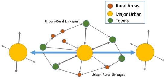
Figure 1. Connectivity and regional setting [23].
References
- Hambarde, A. Connecting Indian Airports by Train: An Exploration Title: Connecting Indian Airports by Train: An Exploration. Urban Stream Revitalisation Better Non-Mot. Transp. City 2018, 1–28.
- OECD. Defining, measuring and improving air connectivity. In Corporate Partnership Board Report; OECD: Paris, France, 2018.
- Sreelekha, M.; Krishnamurthy, K.; Anjaneyulu, M. Interaction between Road Network Connectivity and Spatial Pattern. Procedia Technol. 2016, 24, 131–139.
- Garrison, W. Connectivity of the interstate highway system. Pap. Reg. Sci. 1960, 6, 121–137.
- Florido-Benítez, L. Málaga Costa del Sol airport and its new conceptualization of hinterland. Tour. Crit. Pract. Theory 2021, 2, 195–221.
- Kasarda, J.D. Airport Cities and the Aerotropolis: The Way Forward; Insight Media: London, UK, 2010.
- Wang, J.; Mo, H.; Wang, F.; Jin, F. Exploring the network structure and nodal centrality of China’ s air transport network: A complex network approach. J. Transp. Geogr. 2011, 19, 712–721.
- Redondi, R.; Burghouwt, G. Measuring connectivity in air transport networks: Technical description of the available models. Retrieved Novemb. 2010, 25, 2011.
- Banai, R. Viewpoint: The aerotropolis: Urban sustainability perspectives from the regional city. J. Transp. Land Use 2016, 10, 357–373.
- Preston, R.E. Toward verification of a ‘classical’ centrality model. Tijdschr. Voor Econ. En Soc. Geogr. 1971, 62, 301–307.
- Shen, Y. Understanding Functional Urban Centrality Spatio-Functional Interaction and Its Socio-Economic Impact in Central Shanghai. 2017. Available online: http://discovery.ucl.ac.uk/1559915/18/phd_thesis_final_ys_combined.pdf (accessed on 21 March 2022).
- Burghouwt, G.; Redondi, R. Connectivity in air transport networks an assessment of models and applications. J. Transp. Econ. Policy 2013, 47, 35–53.
- Matsumoto, H.; Veldhuis, J.; de Wit, J.; Burghouwt, G. Network performance, hub connectivity potential, and competitive position of primary airports in Asia/Pacific region. In Proceedings of the Air Transport Research Society Conference, Athens, Greece, 6–10 July 2008.
- Mokhele, M. Spatial Economic Attributes of OR Tambo and Cape Town airport centric developments in South Africa. J. Transp. Supply Chain Manag. 2018, 12, 1–12.
- Kasarda, J.D.; Lindsay, G. Aerotropolis: The Way We’ll Live Next; Farrar, Straus and Giroux: New York, NY, USA, 2011.
- Perera, E.; Dineth, J.; Mahanama, P.K.S.; Gamage, P. A novel approach for planning an aerocity (aerotropolis) in Negombo-Katunayake Peri-Urban Region. Int. J. Adv. Rese. Publications 2019, 3, 8.
- Correia, M.D.F.; de Abreu E Silva, J. A review of airport concepts and their applicability to the new Lisbon airport process. Rev. Port. Estud. Reg. 2015, 38, 47–58.
- Brussel, M.; Zuidgeest, M.; Pfeffer, K.; van Maarseveen, M. Access or Accessibility? A Critique of the Urban Transport SDG Indicator. ISPRS Int. J. Geo-Inf. 2019, 8, 67.
- Chen, S.; Claramunt, C.; Ray, C. A spatio-temporal modelling approach for the study of the connectivity and accessibility of the Guangzhou metropolitan network. J. Transp. Geogr. 2014, 36, 12–23.
- Linard, C.; Gilbert, M.; Snow, R.W.; Noor, A.M.; Tatem, A.J. Population Distribution, Settlement Patterns and Accessibility across Africa in 2010. PLoS ONE 2012, 7, e31743.
- Amal Jose, S.R. Influence of ‘Udan’ Scheme on Network and Regional Connectivity of Indian Airports. Urban India 2019, 39, 16.
- Rodrigue, J.-P. The Geography of Transport Systems; Routledge: Abingdon, UK, 2020.
- Aliance, C. Connecting Systems of Secondary Cities (Issue Table 1). 2019. Available online: https://citiesalliance.org/sites/default/files/2019-07/ca_connectingsystems_web_final%281%29_1.pdf (accessed on 21 March 2022).
More
Information
Subjects:
Regional & Urban Planning
Contributors
MDPI registered users' name will be linked to their SciProfiles pages. To register with us, please refer to https://encyclopedia.pub/register
:
View Times:
1.1K
Revisions:
2 times
(View History)
Update Date:
26 Jan 2024
Table of Contents


Notice
You are not a member of the advisory board for this topic. If you want to update advisory board member profile, please contact office@encyclopedia.pub.
OK
Confirm
Only members of the Encyclopedia advisory board for this topic are allowed to note entries. Would you like to become an advisory board member of the Encyclopedia?
Yes
No
${ textCharacter }/${ maxCharacter }
Submit
Cancel
Back
Comments
${ item }
|
${ item.createdUser.fullName }
${ item.createdAt }
${ item.vote }
${ item.reply }
Delete
${ reply.createdUser.fullName }
${ reply.createdAt }
${ reply.vote }
Delete
There is no reply to this comment~
${ item.replyTextCharacter }/${ item.replyMaxCharacter }
Submit
Cancel
More
No more~
There is no comment~
${ textCharacter }/${ maxCharacter }
Submit
Cancel
${ selectedItem.replyTextCharacter }/${ selectedItem.replyMaxCharacter }
Submit
Cancel
Confirm
Are you sure to Delete?
Yes
No