Your browser does not fully support modern features. Please upgrade for a smoother experience.
Submitted Successfully!
 +1 credit
Thank you for your contribution! You can also upload a video entry or images related to this topic.
For video creation, please contact our Academic Video Service.
| Version | Summary | Created by | Modification | Content Size | Created at | Operation |
|---|---|---|---|---|---|---|
| 1 | Sascha Henninger | -- | 1914 | 2024-01-11 12:12:45 | | | |
| 2 | Fanny Huang | Meta information modification | 1914 | 2024-01-12 07:14:44 | | |
Video Upload Options
We provide professional Academic Video Service to translate complex research into visually appealing presentations. Would you like to try it?
Cite
If you have any further questions, please contact Encyclopedia Editorial Office.
Henninger, S.; Memmel, M.; Mayer, J.; Ruf, J.; Patel, D.; Hoff, L. Urban Trees in Mitigating Climate Impacts. Encyclopedia. Available online: https://encyclopedia.pub/entry/53743 (accessed on 22 July 2026).
Henninger S, Memmel M, Mayer J, Ruf J, Patel D, Hoff L. Urban Trees in Mitigating Climate Impacts. Encyclopedia. Available at: https://encyclopedia.pub/entry/53743. Accessed July 22, 2026.
Henninger, Sascha, Martin Memmel, Julia Mayer, Johannes Ruf, Dhruv Patel, Lena Hoff. "Urban Trees in Mitigating Climate Impacts" Encyclopedia, https://encyclopedia.pub/entry/53743 (accessed July 22, 2026).
Henninger, S., Memmel, M., Mayer, J., Ruf, J., Patel, D., & Hoff, L. (2024, January 11). Urban Trees in Mitigating Climate Impacts. In Encyclopedia. https://encyclopedia.pub/entry/53743
Henninger, Sascha, et al. "Urban Trees in Mitigating Climate Impacts." Encyclopedia. Web. 11 January, 2024.
Copy Citation
Urban tree cadastres, essential for climate adaptation and urban planning, face challenges in maintaining accuracy and completeness. Existing urban vegetation has a large cooling potential. However, it is important to note that all tree species emit varying concentrations of biogenic volatile organic compounds (BVOCs) (e.g. isoprene and terpenes), which can act as precursors for the formation of ground-level ozone.
urban tree cadastre
local emissions
urban trees
1. Introduction
Urban tree cadastres are established and maintained for several reasons, including: The location and species of trees on public land play an increasing role in maintenance planning, especially in light of the expected effects of climate change. In particular, the condition of the trees is important for the municipality to meet its road safety obligations. In addition, trees are essential for urban land-use planning, and, last but not least, they are highly relevant for nature conservation.
The digitisation of the urban tree cadastre has brought other benefits in recent decades: the process of data collection and processing can be made easier and more efficient. Better planning, coordination, and transfer of relevant data can be achieved more quickly due to easier accessibility. This also contributes to more transparent communication. Exporting data also enables analysis and automated applications.
However, keeping the tree cadastre up-to-date, complete, and accurate is a major challenge for municipalities, as it is a very large database that changes regularly.
Various (mostly proprietary) applications support municipal staff with intuitive input masks for editing the municipal tree cadastre. However, the challenge remains that the various characteristics of individual trees or groups of trees, such as species, genus, height, and age, have to be contributed or edited manually. The more attributes a tree cadastre contains, the more time-consuming this becomes, and the more likely it is that incorrect entries will be made due to a lack of time or technical knowledge. Although there are technical tools such as identification applications that can be used for non-trivial characteristics such as height, some characteristics, such as age, can often only be estimated.
For all these reasons, the data quality of urban tree cadastres is often poor and the data cannot be used with confidence. In addition, in the context of climate change, characteristics that have not yet been recorded become relevant. For example, additional site information (tree disc or park, soil composition) can be used to better predict potential drought stress. In addition, German municipal tree cadastres typically only cover trees in public or semi-public areas for which the municipality is responsible. However, private trees are also relevant to air quality and should be included for applications in this area. This is of interest for the potential assessment of areas with high allergy potential due to tree pollen as well as the ozone formation potential due to biogenic hydrocarbon emissions [1].
The initially technical perspective for the development of the corresponding AI creates an explanatory path that provides directional certainty for urban and green space planning and a future perspective. In addition, the spatial planning approach offers the opportunity to introduce further steps towards optimized urban climate adaptation into the scientific and practical planning discourse. This builds a bridge to applied, planning-oriented urban climatology, which is of immense relevance in the aforementioned field of tension.
Preliminary studies have already shown that bioclimatic and air-hygienic factors play an important role in spending time in open spaces and that these differ for different age groups. In addition to its many benefits, green infrastructure can also cause health problems due to so-called biological noxae. One aim must therefore be to use an AI-based tree register to provide a planning basis that is as optimized as possible in terms of local climate, air hygiene, and health [2].
A transdisciplinary approach is being tested in Kaiserslautern (Rhineland-Palatinate, Germany) in order to minimize the time and human resources required for future maintenance of the urban tree cadastre and to integrate other planning and scientific aspects on a large scale. This approach operates on different databases and involves a wide range of stakeholders.
The starting point is the city’s existing tree cadastre, which is incomplete and contains few attributes, but is a good starting point due to its precise GPS locations. A deep learning model can be trained to use arial imagery to detect trees not yet recorded in the tree cadastre. Another AI model will be trained to identify tree species using panoramic imagery and LIDAR data from road surveys. The results will be randomly evaluated by experts, creating a feedback loop that will gradually improve the models.
A web application will be developed to provide a user-friendly interface for researchers and interested citizens to view, edit and add more features to the available data — more models could be trained on this data. Other attributes, such as tree height, can be automatically extracted from the LIDAR data. As part of the process, different databases will be used as training data, considering legal frameworks, costs, and availability, and statements will be made about the quality of the results. Another aim is to make the AI models open and transferable, so that they can be used directly in regions with similar tree populations. In addition, these models could be used to update the tree cadastre and monitor data quality as new information becomes available.
In Germany, several initiatives are available working to improve the urban tree cadastre through the use of technological innovations. In the Metropole Ruhr, for example, the location of trees is determined using similar data and AI [3]. As the models are to be released as open source, they could be integrated into the approach taken in this context. Furthermore, deep learning models for urban tree detection already exist, e.g., Ventura et al. [4] and Weinstein et al. [5].
One successful application of a well-maintained tree register is to involve the public in watering initiatives. In Berlin [6] and Leipzig [7], for example, platforms are used to coordinate and track the watering of urban trees. In Magdeburg [8], information on felled trees is also openly available online.
2. Urban Trees in Mitigating Climate Impacts
The successful implementation of the project requires collaboration among various stakeholder groups, each contributing their expertise. A broad understanding of environment and climate, urban planning, data processing, web design and AI is required and will be addressed by the researchers involved. Public administrations have knowledge of available data, facilitate its accessibility and provide practical use cases. In addition, established communication channels are already in place to connect with citizens and involve them in crowdsourcing activities. On designated action days, interested citizens, supported by researchers, will digitally record tree characteristics over as large an area as possible and validate the results of the AI models.
The research project is part of the collaborative project “Ageing Smart—Designing Spaces Intelligently” funded by the German Carl Zeiss Foundation. The overall project focuses on baby boomers, those born between 1955 and 1969, whose entry into retirement age poses a challenge for local authorities. They are often faced with the need to create not only age-appropriate residential areas, but also appropriate care and leisure structures. The overall aim of the project is to develop a data-based “Decision Support System” (DSS) to assist public administrations in these planning processes. A total of ten subprojects from the departments of Spatial and Environmental Planning, Computer Science and Mathematics at the University of Kaiserslautern-Landau (RPTU) in Kaiserslautern, are working on this topic in an interdisciplinary way. The Fraunhofer Institute for Experimental Software Engineering (IESE) and the German Research Center for Artificial Intelligence (DFKI) GmbH are also involved (see Figure 1).
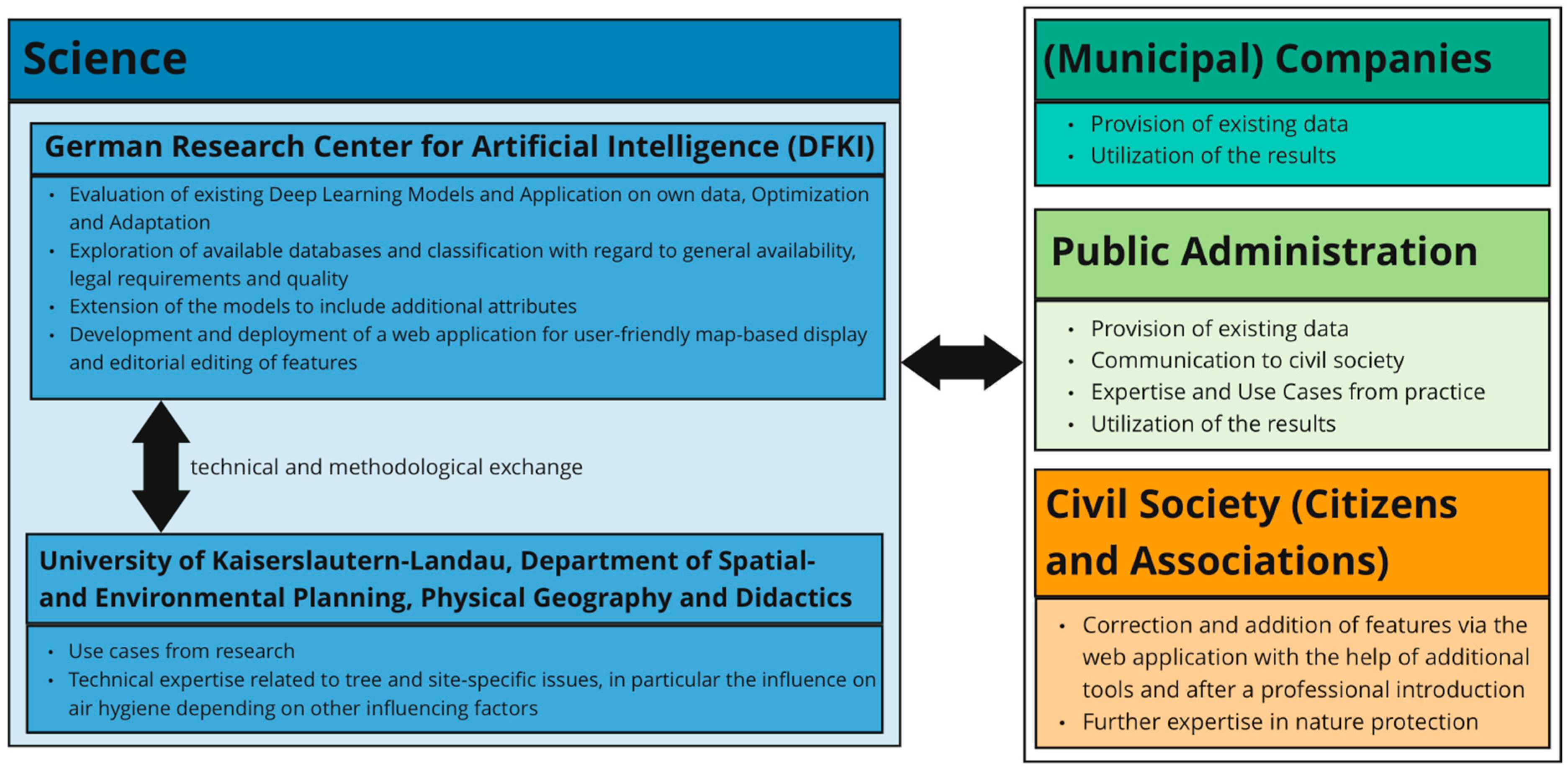
Figure 1. Cooperation network for improving, supplementing, and using the urban tree cadastre.
The Physical Geography sub-project will examine existing local public green spaces to determine whether they can be used equally by all groups of people. Particular attention will be paid to meteorological conditions and local climatic and air quality issues. In the context of the further development of the tree cadastre, the sub-project will provide possible use cases and technical expertise. In the further course of the sub-project, the methodological approach already presented by Albert et al. in 2022 will be transferred to settlement areas. This requires an (almost) complete digital tree cadastre.
The existing urban vegetation has a large cooling potential. However, it is important to note that all tree species emit varying concentration of biogenic volatile organic compounds (BVOCs) (e.g., isoprene and terpenes), which can act as precursors for the formation of ground-level ozone. Particularly in urban green spaces, which serve as recreational areas for many people, poorly composed tree populations are contraindicated as they can lead to significant exposure to harmful ozone. The use of such species along roadsides or in urban green spaces should therefore be avoided. Particularly in urban green spaces, it is important to reduce potential BVOC sources to minimize the formation of O3, which can have adverse effects on human health. Near-surface ozone has the ability to react with particulate matter such as soot, polycyclic aromatic hydrocarbons, or pollen proteins to form oxygen-free radicals.
The possible heterogeneous reactions of ozone with different aerosol particles are of particular interest for urban air quality. So-called reactive oxygen species (ROS) play a key role in chemical transformations and adverse health effects [9][10]. They are closely linked through radical reactions and cyclic transformation into toxic or allergenic airborne particles. Different types of ROS can pass through different types of tissues such as the human respiratory tract [11]. Many heterogeneous reactions of O3 with aerosol particles are also being studied. Polycyclic aromatic hydrocarbons (PAHs) are a prominent group of organic aerosol constituents that could readily react with ozone to the detriment of human health. PAHs are an integral part of soot and other carbonaceous combustion aerosol particles. They have the ability to penetrate deep into the human lungs. A chemical reaction with O3 can alter their toxicity. Ozone can also promote the nitration of protein molecules contained in biological aerosol particles such as pollen or fungal spores [12][13]. This reaction can increase the allergenic potential of proteins. As a result, airborne soot or pollen can become toxic through oxidation or nitrification processes. This causes inflammation and inhaled allergens can increase the risk of respiratory diseases [14].
One such BVOC is the biogenic hydrocarbon isoprene. Due to its high reactivity, it can form ozone. Compared to anthropogenic hydrocarbons, the precursor isoprene can lead to such O3 formation at extremely low concentration. The emission rate depends on the meteorological conditions and their effect on the vegetation (leaf temperature) [15]. According to this, clear and calm weather conditions with high solar radiation and a high air temperature are most likely to lead to a high emission rate of isoprene from plant leaves.
The SmartCity Living Lab team of the DFKI is responsible for data governance and data management to ensure sufficient data quality, as results and implementations are based on heterogeneous data. Adequate and high quality databases are crucial for the quality of automated applications and artificial intelligence methods. Conversely, as in this case, AI can also be used to create or improve a desired database.
The city of Kaiserslautern was selected as one of seven model communities in the project and has been working closely with researchers from DFKI and RPTU for several years as part of the Model Project Smart Cities (MPSC) funded by the German Federal Ministry of Housing, Urban Development, and Construction (Bundesministerium für Wohnen, Stadtentwicklung und Bauwesen, BMWSB). It provides data, establishes links between different stakeholders and uses its channels of communication with citizens to actively involve them.
References
- Albert, L.; Fröhlich, N.; Hausbrand, N.; Henninger, S.; Maurer, T.; Ruzika, S. Human-biometeorologisch angepasste Routenführungen durch mathematische Optimierung. In Mobility, Knowledge and Innovation Hubs in Urban and Regional Development, Proceedings of the REAL CORP 2022, 27th International Conference on Urban Development, Regional Planning and Information Society, Vienna, Austria, 14–16 November 2022; CORP—Competence Center of Urban and Regional Planning: Vienna, Austria, 2022; pp. 427–435.
- Henninger, S. The Impact of Biogenic Isoprene in Dependence on Meteorological Conditions within Urban Green. In Urban Environment-Proceedings of the 11th Urban Environment Symposium (UES), Karlsruhe, Germany, 16–19 September 2012; Rauch, S., Morrison, G., Norra, S., Schleicher, N., Eds.; Springer: Dordrecht, The Netherlands, 2014; pp. 153–162.
- Metz, M.; Weinmann, A.; Krisztian, L. Automatisierte Detektion von Baumstandorten in der Metropole Ruhr. In Proceedings of the Tagungsband FOSSGIS-Konferenz, Berlin, Germany, 15–18 March 2023; p. 161.
- Ventura, J.; Pawlak, C.; Honsberger, M.; Gonsalves, C.; Rice, J.; Love, N.L.R.; Han, S.; Nguyen, V.; Sugano, K.; Doremus, J.; et al. Individual Tree Detection in Large-Scale Urban Environments using High-Resolution Multispectral Imagery. arXiv 2022, arXiv:2208.10607.
- Weinstein, B.G.; Marconi, S.; Bohlman, S.; Zare, A.; White, E. Individual Tree-Crown Detection in RGB Imagery Using Semi-Supervised Deep Learning Neural Networks. Remote Sens. 2019, 11, 1309.
- Technologiestiftung Berlin, Gieß den Kiez. Available online: https://www.giessdenkiez.de (accessed on 14 June 2023).
- Open Knowledge Foundation Deutschland e.V. Available online: https://codeforleipzig.github.io/giessdeibohm/ (accessed on 14 June 2023).
- Winter, J. Baumfreunde Magdeburg. Available online: https://www.baumfreunde-md.de/home (accessed on 14 June 2023).
- Venkatarchi, P.; Hopke, P.K. Development and evaluation of a particle-bound reactive oxygen species generator. J. Aerosol Sci. 2008, 39, 168–174.
- Apel, K.; Hirt, H. Reactive Oxygen Species: Metabolism, Oxidative Stress, and Signal Transduction. Annu. Rev. Plant Biol. 2004, 55, 373–399.
- George, I.J.; Abbat, J.P.D. Heterogeneous oxidation of atmospheric aerosol particles by gasphase radicals. Nat. Chem. 2010, 2, 713–722.
- Franze, T.; Weller, M.G.; Niessner, R.; Pöschl, U. Protein nitration by polluted air. Environ. Sci. Technol. 2005, 39, 1673–1678.
- Fröhlich-Nowoisky, J.; Pickersgill, D.A.; Despres, V.R.; Pöschl, U. High diversity of fungi in air particulate matter. Proc. Natl. Acad. Sci. USA 2009, 106, 12814–12819.
- Shiraiwa, M.; Sosedova, Y.; Rouviere, A.; Yang, H.; Zhang, Y.; Abbat, J.P.D.; Ackermann, M.; Pöschl, U. The role of long-lived reactive oxygen intermediates in the reaction of ozone with aerosol particles. Nat. Chem. 2011, 3, 291–295.
- Guenther, A.B.; Monson, R.L.; Fall, R. Isoprene and monoterpene emission rate variability: Observation with Eucalyptus and emission rage algorithm development. J. Geophys. Res.-Atmos. 1991, 96, 10799–10808.
More
Information
Subjects:
Area Studies
Contributors
MDPI registered users' name will be linked to their SciProfiles pages. To register with us, please refer to https://encyclopedia.pub/register
:
View Times:
589
Revisions:
2 times
(View History)
Update Date:
16 Jan 2024
Table of Contents


Notice
You are not a member of the advisory board for this topic. If you want to update advisory board member profile, please contact office@encyclopedia.pub.
OK
Confirm
Only members of the Encyclopedia advisory board for this topic are allowed to note entries. Would you like to become an advisory board member of the Encyclopedia?
Yes
No
${ textCharacter }/${ maxCharacter }
Submit
Cancel
Back
Comments
${ item }
|
${ item.createdUser.fullName }
${ item.createdAt }
${ item.vote }
${ item.reply }
Delete
${ reply.createdUser.fullName }
${ reply.createdAt }
${ reply.vote }
Delete
There is no reply to this comment~
${ item.replyTextCharacter }/${ item.replyMaxCharacter }
Submit
Cancel
More
No more~
There is no comment~
${ textCharacter }/${ maxCharacter }
Submit
Cancel
${ selectedItem.replyTextCharacter }/${ selectedItem.replyMaxCharacter }
Submit
Cancel
Confirm
Are you sure to Delete?
Yes
No