Submitted Successfully!
To reward your contribution, here is a gift for you: A free trial for our video production service.
Thank you for your contribution! You can also upload a video entry or images related to this topic.
Version Summary Created by Modification Content Size Created at Operation
1 -- 2725 2023-12-31 12:25:45 |
2 format correct + 9 word(s) 2734 2024-01-02 02:15:59 |

Video Upload Options

Do you have a full video?

Confirm

Are you sure to Delete?
Cite
If you have any further questions, please contact Encyclopedia Editorial Office.
Bando, Y.; Yoh, K.; Sou, K.; Chou, C.; Doi, K. AI-Based Evaluation of Streets for People in Bangkok. Encyclopedia. Available online: https://encyclopedia.pub/entry/53291 (accessed on 18 May 2024).
Bando Y, Yoh K, Sou K, Chou C, Doi K. AI-Based Evaluation of Streets for People in Bangkok. Encyclopedia. Available at: https://encyclopedia.pub/entry/53291. Accessed May 18, 2024.
Bando, Yuka, Kento Yoh, Kanyou Sou, Chun-Chen Chou, Kenji Doi. "AI-Based Evaluation of Streets for People in Bangkok" Encyclopedia, https://encyclopedia.pub/entry/53291 (accessed May 18, 2024).
Bando, Y., Yoh, K., Sou, K., Chou, C., & Doi, K. (2023, December 31). AI-Based Evaluation of Streets for People in Bangkok. In Encyclopedia. https://encyclopedia.pub/entry/53291
Bando, Yuka, et al. "AI-Based Evaluation of Streets for People in Bangkok." Encyclopedia. Web. 31 December, 2023.
AI-Based Evaluation of Streets for People in Bangkok
Edit

Bangkok, the capital of Thailand, grapples with several urban challenges, including traffic accidents, congestion, and underdeveloped sidewalks. These issues stem from the escalating use of private cars and motorcycles driven by rapid urbanization, accompanying economic growth, and the unique street geometry of the city. Furthermore, despite the development of railroads, issues persist with the poor walking environment for pedestrian access to stations, posing a challenge to the promotion of safe and environmentally friendly public transportation. This study evaluated streets’ spatial performance, focusing on the performance of soi, the intricate network of narrow urban pathways in Bangkok. Leveraging an AI model capturing pedestrian value, this study subsequently assessed accessibility from typical residential areas to public transportation stations. The findings shed light on the challenges faced by sois in Bangkok. Based on the findings, practical implications were discussed and provided to inform urban designers, with the aim of promoting public transportation usage and encouraging a more sustainable urban form.

walkability lingerability AI evaluation pedestrian Bangkok

1. Introduction

In recent years, rapid urbanization and dramatic economic growth in Bangkok have led to explosive growth in motorization, resulting in issues such as traffic accidents and congestion [1]. Although railway development is progressing [2], the city’s unique urban structure and impractical sidewalks present challenges for pedestrians seeking access to stations, impeding the promotion of safe and environmentally friendly public transportation options [3]. Bangkok’s distinctive urban structure comprises superblocks measuring 2–4 km by 2–4 km. The road network is delineated by trunk roads called “thanon” and smaller residential roads referred to as “soi” in Thai, resembling fish bones [4]. These sois, branching off major roads (thanon), extend into central blocks. Originally utilized as waterways, many sois now function as dead-end roads, varying in length from short meters to several kilometers, such as Sukhumvit Street and Phahon Yothin Street [5]. Within the superblocks, sois run parallel. To travel from a residential area situated in the center of a superblock to another soi or to exit the area, residents must exit once to the thanon. This results in a notable disparity between the straight-line distance to the destination and the actual distance of the shortest route. Additionally, the presence of numerous street vendors and motorcycle parking contributes to chronic traffic congestion. The streets further face challenges such as poor road surface quality and elevated sidewalks designed for flood control. Consequently, the walking conditions on the streets of Bangkok are deemed inadequate [6][7].
The importance of enhancing the pedestrian environment is underscored by international initiatives. Specifically, the rising concern for sustainable cities has heightened the focus on urban planning that is pedestrian-friendly and conducive to walking [8][9][10][11]. The significance of dynamic urban planning to address diverse risks, including natural disasters and pandemics, has also garnered attention. As a result, there is a growing need for insights into the walkability and accessibility of cities through walking and public transportation [12][13].
In Thailand, the government has embraced a novel initiative known as “Thailand 4.0” [14], designed to foster emerging industries such as next-generation mobilities and smart technologies [15]. The overarching goal is to build smart cities that leverage advanced technologies, including AI, to enhance environmental sustainability and the quality of life (QoL) of its citizens. In pursuit of this vision, a collaborative research project between Thailand, JICA, and JST is underway [16]. As part of this initiative, an intelligent transportation strategy named the “Sukhumvit Model” is developed in the congested Vadhana district, located at the center of Bangkok. The proposed strategy is driven by twin objectives: enhancing the QoL for citizens and establishing a low-carbon society, incorporating measures such as traffic simulation, the introduction of shared small-format mobility options, and improvements to the walkability within the Sukhumvit area [16].

2. Walkability in Bangkok

2.1. Evaluating the Walkability of Streets

Walking is considered a sustainable mode of transportation that contributes to people’s health, well-being, and the maintenance of physical activity. Moreover, walkability has been demonstrated to impact sustainability from economic, social, and environmental perspectives. In other words, it not only enhances health and social equity but also reduces greenhouse gas emissions [17][18].
Numerous definitions of walkability have been proposed. Most interpretations emphasize the ease of access to destinations and proximity, considering land use and routes. These definitions predominantly focus on physical environmental factors like sidewalk width, the number of traffic lanes, safe speeds, connectivity, intersections, and pedestrian service levels [19][20][21][22][23][24]. Additionally, walkability is also characterized by comfort during walking, encompassing psychological and environmental factors. These factors involve elements such as the presence of greenery and water, cleanliness, traffic volume, aesthetically pleasing buildings, vegetation, lighting, and a sense of security [25][26][27][28][29][30].
There are also varying perspectives when evaluating the level of walkability. For subjective evaluation, common methods include questionnaires and interviews to gauge pedestrians’ subjective perceptions of the built environment [31][32][33][34][35]. Gorrini et al. conducted a qualitative walkability assessment of Venice’s historic center by utilizing open data from public agencies and on-site observations, revealing that a lack of essential services, tourist crowds, and insufficient signage affect walkability [36]. Millington et al. demonstrated that the Scottish Walkability Assessment Tool (SWAT), designed to objectively record physical environment aspects related to walking in Scottish urban areas, can potentially assess walkability [37].
Geographic Information Systems (GIS) are used as an effective tool for objective assessment [38][39][40][41]. Especially in the field of urban planning, many studies have employed GIS and geodatabases to assess walkability, involving measures such as neighborhood connectivity, housing density, land use, proximity, etc. [22][42][43][44][45][46][47]. In Frank et al.’s study, walkability was quantified and assessed using indices based on land use, net residential density, intersection density, street connectivity, and retail floor area ratio [48][49]. Regarding environmental factors that significantly influence walkability, a recent study conducted by Isinkaralar [50] focused on outdoor thermal comfort under various climate change scenarios. The study employed spatial and temporal modeling through GIS to delineate bioclimatic comfort areas.
Some studies have incorporated the Walk Score service [51] into their walkability assessments, which score facilities within a 1-mile (1.6-km) radius. Carr et al. showed a significant correlation between Walk Score and multiple objective-built environment measures of physical activity, including connectivity, residential density, and access to transit [52]. Despite limited empirical evidence on the Walk Score’s potential to estimate neighborhood walkability, Duncan et al. explored its utility and applicability in the field of public health research. The Walk Score is suggested as a valid substitute for specific neighborhood walkability indicators such as retail destinations, intersection density, and population density [53]. In a unique approach, Otsuka et al. introduced a modified version of the Walk Score to evaluate walkability specifically concerning access to railway stations in urban areas. The walkability indicators are based on four key criteria: urban form, street design, obstacles, traffic safety, and personal perception. The adapted method employs a point deduction system for traffic-related obstacles, including factors such as traffic noise, pedestrian casualties, road speed limits, and air quality [30]. However, it is crucial to note that Walk Score is currently available only in some cities in America, the UK, Canada, and Australia. Sou et al. have developed an image recognition technique based on deep learning to evaluate the walkability and lingerability of streets [54][55]. This facilitates the continual and objective evaluation of street space.
As demonstrated above, numerous walkability assessment methods have been proposed, each providing a distinct definition of walkability.

2.2. Streets and the Walking Situation in Bangkok

To promote walking to transit stations, pedestrian-friendly environments must be created with mixed land use and high population densities around stations. However, the widespread adoption of motorization has diminished walking as a prevalent mode of transportation. This shift is particularly pronounced in urban areas, as exemplified by cities such as Bangkok. Despite the expanding population in the vicinity of public transportation stations due to urban development, there is a noticeable reluctance to embrace walking as a daily commuting option. As a result, the use of rail services remains limited [56]. This trend underscores the necessity for targeted interventions and urban planning strategies focused on improving walkability, thereby contributing to the overall sustainability of the city.
Acceptable walking distances (AWDs) to public transit in Bangkok have been surveyed in several studies, revealing that the AWD in Bangkok’s tropical climate is shorter than in cities located in colder regions, resulting in lower walking frequency [56][57][58][59]. Chalermpong et al. showed that in Bangkok, the primary modes of accessing public transit are private cars, buses, or motorcycle taxis, with walking constituting only around 15% of the total share. Additionally, alternative green modes, such as bicycles, were found to be almost non-existent. The study also identified factors influencing walking access to transit stations, including not just walking distance but also considerations of comfort, physical characteristics, land use patterns, road network structure, and integration with other modes.
Walking in central Bangkok is challenging due to the absence of sidewalks, numerous obstacles, and poor surface quality [59]. Ozawa et al. used the Analytical Hierarchy Process (AHP) to quantify the importance (weight) of various road space elements. Their findings indicated that factors such as the presence of sidewalks, hazards, steps, obstacles, and road width significantly impact the walkability of Bangkok’s sidewalks. The conclusion drawn was that enhancing safety and comfort is important for improving walkability [60]. Pongprasert et al. suggested that many Bangkok residents do not find walking enjoyable when accessing stations, emphasizing that comfortable and cozy streets possess higher-order qualities than simply walkable streets [61]. To enhance the on-street experience, the study recommended the installation of eco-friendly small mobility services in areas where the access road quality is insufficient.
Building upon the findings from the literature, this study aims to evaluate the spatial performance of streets from pedestrians’ viewpoint, focusing on both walkability and the comfort of the street environment, particularly targeting the narrow residential streets known as soi in Thailand. Specifically, this study quantitatively assesses the subjective value measure of pedestrian comfort in urban spaces using deep learning. By evaluating pedestrian accessibility considering psychological resistance, the researchers reevaluate the connectivity of residential streets and seek to provide insights for more effective utilization.
The evaluation results will be employed and analyzed to assess the level of accessibility from a typical residential area in Bangkok to nearby transit. The findings of this study help identify problems faced by soi, and potential improvement measures will be discussed to promote the use of public transit use as a means to encourage sustainable transport and urban development.

3. Walkability Evaluation of Streets

3.1. AI-Based Street Evaluation

As discussed in the previous chapter, various methods have been proposed to evaluate the walkability of streets. Highlighted by Pongprasert et al. [61], the need to evaluate coziness and comfortability is particularly pertinent in the context of Bangkok. Common evaluation methods that delve into human values typically involve interviews and questionnaires. While effective, these approaches are known to be costly and time-consuming [62][63].
Conversely, image recognition methods based on deep learning have gained prominence across various fields in recent years. In urban planning, the application of Convolutional Neural Networks (CNN) to images of urban spaces has enabled the quantification of impressions related to the urban environment [64][65][66]. This study endeavors to evaluate street spaces, including value judgments, using CNN. To achieve this, this study employs AI and human co-operative evaluation (AIHCE), a street space evaluation method using deep learning developed by Sou et al. [54][55]. AIHCE consists of two evaluation methods. The first is the “street image evaluation model”, which directly assesses the impression of a space based on data labeled with the appearance of a street space. The second is the “facial expression recognition model”, which indirectly evaluates the street space by estimating emotions from the data of facial expressions during walking. In this study, the “street image evaluation model” was used.
The model incorporates two indices: walkability and lingerability, providing an assessment of the impression of a space based on street images. Sou et al. classified street space quality according to spatial performance on three hierarchical levels. The fundamental level involves usability and legibility. The intermediate level is walkability, indicating the capability to pass through space safely, smoothly, and comfortably. At the highest conceptual level is lingerability, defined as the performance that encompasses the comfort of lingering in space, allowing individuals to enjoy the enduring positive experience across time and space. The study asserts that enhancing lingerability, focusing on slow walking alongside walkability for passing through, is necessary for creating streetscapes that encourage walking and contribute to enhancing happiness. Evaluating both walkability and lingerability provides a comprehensive understanding of spatial performance [54][55]. Utilizing streetscape images, the image determination method evaluates street spatial performance through the suggested two indices: walkability and lingerability.
For the street image evaluation, the CNN model was trained on a dataset of street images with semantic labels collected from the internet [67]. In terms of linguistic labels, the researchers set “walkable street” and “unwalkable street” to denote walkability, while “cozy street” and “dirty street” represented lingerability. Within the set of street image data, images that could not be identified as actual images of a walking space were removed. A total of 520 shots (260 for each keyword) were used as the training data (Table 1). The AI model was trained through fine-tuning using this dataset. Fine-tuning is a technique that achieves high accuracy even with a small number of training data. In this study, fine-tuning was conducted based on the pre-existing VGG16 learning model.

Table 1. The data used for fine-tuning model

Evaluation indices

Search keys

Number of images

Training data

Validation data

Lingerability

cozy street

260

220

40

dirty street

260

220

40

Walkability

walkable street

260

220

40

Unwalkable street

260

220

40

Figure 1. Street Image Evaluation Model (SIEM) as part of AIHCE.

3.2. Input Data

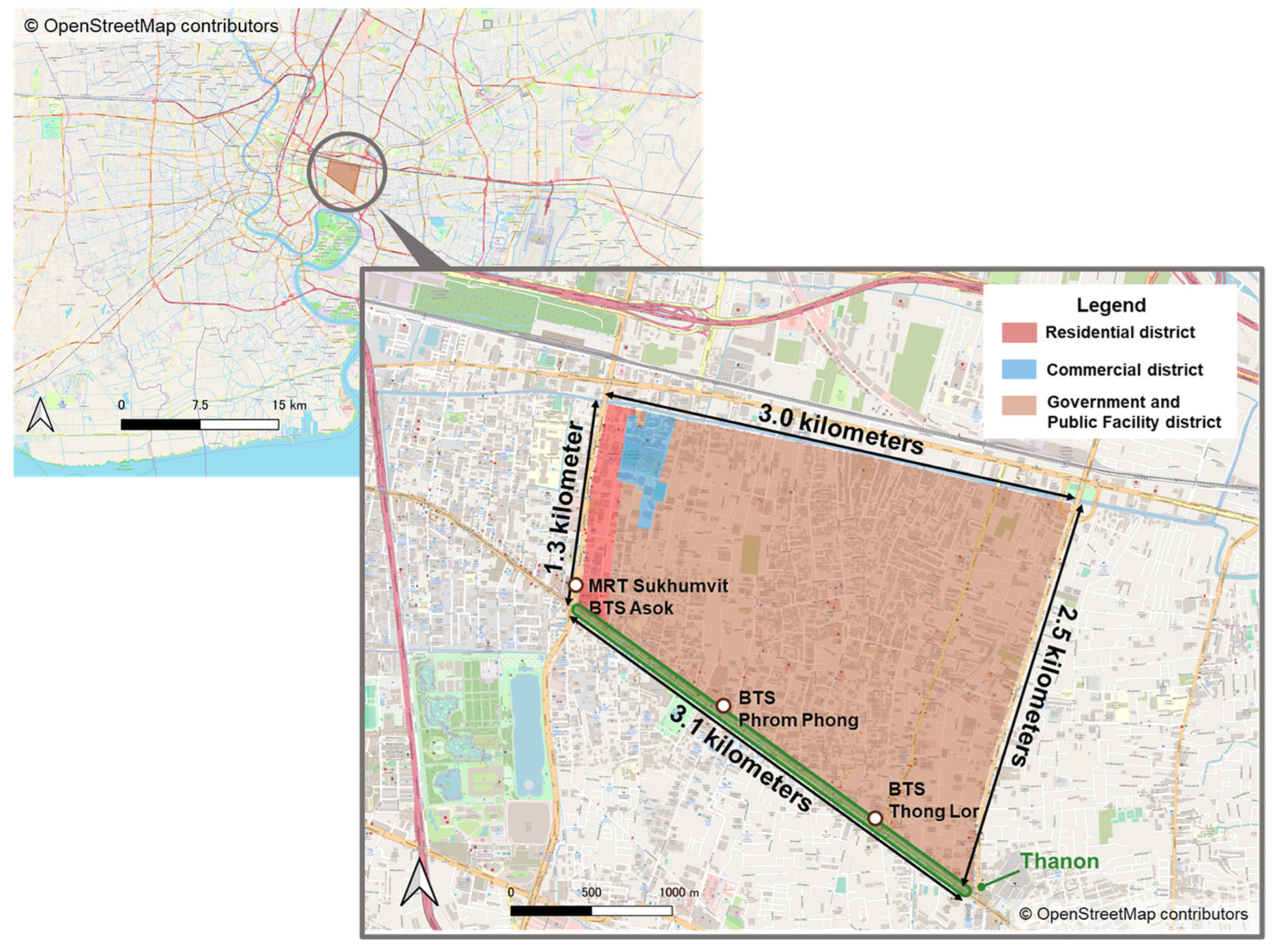
The study area is the Sukhumvit area, situated in the Vadhana district of Bangkok, which is marked by severe traffic congestion (Figure 2). The Sukhumvit area, situated in the heart of Bangkok, is a typical location that is currently experiencing traffic issues such as congestion and accidents. As a central hub, it represents a prime example where problems arising from urbanization and motorization are already manifest. These challenges are expected to intensify with further urban and motorization expansion in the future. Consequently, this study focused on the Sukhumvit area, a single superblock where various transportation issues are already prevalent, conducting research to address these challenges proactively. The study area is encompassed by roads of varying lengths, measuring 1.3, 2.5, 3, and 3.1 km.

Figure 2. Study area.
The surrounding thanon have high traffic volumes and are flanked by numerous commercial facilities, offices, and hotels. In contrast, upon entering the soi, there is a noticeable increase in residential areas. The southern end of the study area is anchored by Sukhumvit Road thanon, featuring the BTS Skytrain. In contrast, the western end is characterized by Asok Road thanon, accommodating the MRT underground.
The employed AI and human co-operative evaluation (AIHCE) adopts a dataset consisting of collected image data on a global scale. This approach aims to evaluate streets in diverse urban environments using consistent criteria. Given that the dataset incorporates information from diverse locations, including developing countries like Bangkok, it was employed for the evaluation in this study.
Firstly, the researchers conducted a video camera survey, capturing footage while walking on all sidewalks and streets within the study area. The videos were recorded during two periods: from 19–28 August and 23–26 October 2022, spanning from 9:00 a.m. to 5:00 p.m. to ensure consistent sunlight conditions. The weather during these periods was either sunny or cloudy, taking into consideration the potential impact of darker images on recognition accuracy. Subsequently, the captured video images were segmented into one-second intervals. Finally, the researchers fed this data into the AIHCE model, which generated continuous WI and LI for each street. The WI and LI values were aggregated by a street link, and the average value was utilized as the evaluation metric for street links.

References

  1. WHO. WHO Global Status Report on Road Safety 2018; WHO: Geneva, Switzerland, 2018; p. 245.
  2. BTS Group Holdings PCL. Annual Report 2022/23 (FORM 56-1 ONE REPORT); BTS Group Holdings PCL: Bangkok, Thailand, 2023; pp. 36–40.
  3. Fukuda, A. Current Situation of Land Development in the Area along Rail Based Public Transport Systems in Bangkok—Limit and Possibility; IBS Annual Report; Kenkyu Katsudou Houkoku: Tokyo, Japan, 2017; pp. 71–76.
  4. Allison, G.H. Jumbo English-Thai Dictionary, 3rd ed.; Odeon Store: Bangkok, Thailand, 1978.
  5. Cohen, E. A soi in Bangkok: The dynamics of lateral urban expansion. J. Siam Soc. 1985, 73, 1–35.
  6. Watanabe, S.; Tsuboi, Y.; Akiyama, S.; Hoshihara, M.; Watanabe, Y. Study on characteristic of Urban street structure of Bangkok—A Relation of the Soi and Pakksoi in the Sukhumvit Area part1. Summ. Tech. Pap. Annu. Meet. Archit. Inst. Jpn. 2008, F-1, 969–970.
  7. Yingyeod, S. Soi Problem on the Rise. Bangkok Post 1971, 25, 7.
  8. Moreno, C.; Allam, Z.; Chabaud, D.; Gall, C.; Pratlong, F. Introducing the “15-Minute City”: Sustainability, Resilience and Place Identity in Future Post-Pandemic Cities. Smart Cities 2021, 4, 93–111.
  9. Ulloa-Leon, F.; Correa-Parra, J.; Vergara-Perucich, F.; Cancino-Contreras, F.; Aguirre-Nuñez, C. “15-Minute City” and Elderly People: Thinking about Healthy Cities. Smart Cities 2023, 6, 1043–1058.
  10. Khavarian-Garmsir, A.R.; Sharifi, A.; Hajian Hossein Abadi, M.; Moradi, Z. From Garden City to 15-Minute City: A Historical Perspective and Critical Assessment. Land 2023, 12, 512.
  11. Eggimann, S. The potential of implementing superblocks for multifunctional street use in cities. Nat. Sustain. 2022, 5, 406–414.
  12. Carra, M.; Rossetti, S.; Tiboni, M.; Vetturi, D. Urban regeneration effects on walkability scenarios. TeMA J. Land Use Mobil. Environ. 2022, 16, 101–114.
  13. Russo, A.; Campisi, T.; Tesoriere, G.; Annunziata, A.; Garau, C. Accessibility and Mobility in the Small Mountain Municipality of Zafferana Etnea (Sicily): Coupling of Walkability Assessment and Space Syntax. In Proceedings of the International Conference on Computational Science and Its Applications, Malaga, Spain, 4–7 July 2022; pp. 338–352.
  14. Thailand4.0—(thaiembdc.org). Available online: https://thaiembdc.org/thailand-4-0-2/ (accessed on 11 October 2023).
  15. Oizumi, K. “Thailand 4.0” toha nanika (zenpen)—Kouseityou-rosen ni kaji wo kiru Thai. Kan-Taiheiyou Bizinesu Zyouhou RIM 2017, 17, 91–103.
  16. The Project of Smart Transport Strategy for Thailand. Available online: https://www.jica.go.jp/project/thailand/034/index.html (accessed on 11 October 2023).
  17. Baobeid, A.; Koç, M.; Al-Ghamdi, S.G. Walkability and Its Relationships with Health, Sustainability, and Livability: Elements of Physical Environment and Evaluation Frameworks. Front. Built Environ. 2021, 7, 721218.
  18. Rafiemanzelat, R.; Emadi, I.M.; Kamali, J.A. City sustainability: The influence of walkability on built environments. Transp. Res. Procedia 2017, 24, 97–104.
  19. Dowling, R.; Reinke, D. Multimodal Level of Service Analysis for Urban Streets, Users Guide; Transportation Research Board: Washington, DC, USA, 2008.
  20. John, I.G.; William, W.R.; Wesley, L.M. Does walkability matter? An examination of walkability’s impact on housing values, foreclosures and crime. Cities 2015, 42, 13–24.
  21. Lo, R.H. Walkability: What is it? J. Urban 2009, 2, 145–166.
  22. Leslie, E.; Coffee, N.; Frank, L.; Owen, N.; Bauman, A.; Hugo, G. Walkability of local communities: Using geographic information systems to objectively assess relevant environmental attributes. Health Place 2007, 13, 111–122.
  23. Villanueva, K.; Knuiman, M.; Nathan, A.; Giles-Corti, B.; Christian, H.; Foster, S.; Bull, F. The impact of neighborhood walkability on walking: Does it differ across adult life stage and does neighborhood buffer size matter? Health Place 2014, 25, 43–46.
  24. Zhang, J.; Tan, P.Y.; Zeng, H.; Zhang, Y. Walkability assessment in a rapidly urbanizing city and its relationship with residential estate value. Sustainability 2019, 11, 2205.
  25. Craig, C.L.; Brownson, R.C.; Cragg, S.E.; Dunn, A.L. Exploring the effect of the environment on physical activity: A study examining walking to work. Am. J. Prev. Med. 2002, 23, 36–43.
  26. Clifton, K.J.; Smith, A.D.L.; Rodriguez, D. The development and testing of an audit for the pedestrian environment. Landsc. Urban Plan. 2007, 80, 95–110.
  27. Day, K.; Boarnet, M.; Alfonzo, M.; Forsyth, A. The Irvine–Minnesota inventory to measure built environments: Development. Am. J. Prev. Med. 2006, 30, 144–152.
  28. Saelens, B.E.; Handy, S.L. Built environment correlates of walking: A review. Med. Sci. Sports Exerc. 2008, 40 (Suppl. S7), S550.
  29. Park, S.; Choi, K.; Lee, J.S. To walk or not to walk: Testing the effect of path walkability on transit users’ access mode choices to the station. Int. J. Sustain. Transp. 2015, 9, 529–541.
  30. Otsuka, N.; Wittowsky, D.; Damerau, M.; Gerten, C. Walkability assessment for urban areas around railway stations along the Rhine-Alpine Corridor. J. Transp. Geogr. 2021, 93, 103081.
  31. Kelly, C.E.; Tight, M.R.; Hodgson, F.C.; Page, M.W. A comparison of three methods for assessing the walkability of the pedestrian environment. J. Transp. Geogr. 2011, 19, 1500–1508.
  32. Gkavra, R.; Nalmpantis, D.; Genitsaris, E.; Naniopoulos, A. The walkability of Thessaloniki: Citizens’ perceptions. Paving Way Sustain. Urban Mobil. 2019, 879, 191–198.
  33. Artigues, G.; Mateo, S.; Ramos, M.; Cabeza, E. Validation of the Urban Walkability Perception Questionnaire (UWPQ) in the Balearic Islands. Int. J. Environ. Res. Public Health 2020, 17, 6631.
  34. Fonseca, F.; Papageorgiou, G.; Tondelli, S.; Ribeiro, P.; Conticelli, E.; Jabbari, M.; Ramos, R. Perceived walkability and respective urban determinants: Insights from Bologna and Porto. Sustainability 2022, 14, 9089.
  35. Arshad, A.K.; Bahari, N.I.; Hashim, W.; Halim, A.A. Gender differences in pedestrian perception and satisfaction on the walkability of Kuala Lumpur city center. MATEC Web Conf. 2016, 47, 03003.
  36. Gorrini, A.; Bertini, V. Walkability assessment and tourism cities: The case of Venice. Int. J. Tour. Cities 2018, 4, 355–368.
  37. Millington, C.; Thompson, C.W.; Rowe, D.; Aspinall, P.; Fitzsimons, C.; Nelson, N. SPARColl—The Scottish Physical Activity Research Collaboration. Development of the Scottish walkability assessment tool (SWAT). Health Place 2009, 15, 474–481.
  38. Isinkaralar, O.; Isinkaralar, K.; Sevik, H.; Küçük, Ö. Spatial modeling the climate change risk of river basins via climate classification: A scenario-based prediction approach for Türkiye. Nat. Hazards 2023, 1–18.
  39. Isinkaralar, O. A Climate-Sensitive Approach for Determining the Urban Growth Boundaries: Towards a Spatial Exploration for Bursa, Türkiye. J. Urban Plan. Dev. 2023, 149, 4.
  40. Isinkaralar, O.; Isinkaralar, K.; Bayraktar, E.P. Monitoring the spatial distribution pattern according to urban land use and health risk assessment on potential toxic metal contamination via street dust in Ankara, Türkiye. Environ. Monit. Assess. 2023, 195, 1085.
  41. Isinkaralar, O.; Isinkaralar, K.; Yilmaz, D. Climate-related spatial reduction risk of agricultural lands on the Mediterranean coast in Türkiye and scenario-based modelling of urban growth. Environ. Dev. Sustain. 2023, 25, 13199–13217.
  42. Stockton, J.C.; Duke-Williams, O.; Stamatakis, E.; Mindell, J.S.; Brunner, E.J.; Shelton, N.J. Development of a novel walkability index for London, United Kingdom: Cross-sectional application to the Whitehall II Study. BMC Public Health 2016, 16, 416.
  43. Aultman-Hall, L.; Roorda, M.; Baetz, B.W. Using GIS for evaluation of neighborhood pedestrian accessibility. J. Urban Plan. Dev. 1997, 123, 10–17.
  44. Owen, N.; Cerin, E.; Leslie, E.; Coffee, N.; Frank, L.D.; Bauman, A.E.; Sallis, J.F. Neighborhood walkability and the walking behavior of Australian adults. Am. J. Prev. Med. 2007, 33, 387–395.
  45. Kuzmyak, J.; Baber, C.; Savory, D. Use of Walk Opportunities Index to Quantify Local Accessibility. Transp. Res. Rec. J. Transp. Res. Board 2006, 1977, 145–153.
  46. Tsiompras, A.B.; Photis, Y.N. What matters when it comes to “Walk and the city”? Defining a weighted GIS-based walkability index. Transp. Res. Procedia 2017, 24, 523–530.
  47. García-Palomares, J.C.; Gutiérrez, J.; Cardozo, O.D. Walking accessibility to public transport: An analysis based on microdata and GIS. Environ. Plan. B Plan. Des. 2013, 40, 1087–1102.
  48. Frank, L.D.; Schmid, T.L.; Sallis, J.F.; Chapman, J.; Saelens, B.E. Linking objectively measured physical activity with objectively measured urban form: Findings from SMARTRAQ. Am. J. Prev. Med. 2005, 28, 117–125.
  49. Frank, L.D.; Sallis, J.F.; Conway, T.L.; Chapman, J.E.; Saelens, B.E.; Bachman, W. Many Pathways from Land Use to Health: Associations between Neighborhood Walkability and Active Transportation, Body Mass Index, and Air Quality. J. Am. Plan. Assoc. 2007, 72, 75–87.
  50. Isinkaralar, O. Bioclimatic comfort in urban planning and modeling spatial change during 2020–2100 according to climate change scenarios in Kocaeli, Türkiye. Int. J. Environ. Sci. Technol. 2023, 20, 7775–7786.
  51. Walk Score Methodology. Available online: https://www.walkscore.com/methodology.shtml (accessed on 15 October 2023).
  52. Carr, L.J.; Dunsiger, S.I.; Marcus, B.H. Walk score as a global estimate of neighborhood walkability. Am. J. Prev. Med. 2010, 39, 460–463.
  53. Duncan, D.T.; Aldstadt, J.; Whalen, J.; Melly, S.J.; Gortmaker, S.L. Validation of Walk Score® for estimating neighborhood walkability: An analysis of four US metropolitan areas. Int. J. Environ. Res. Public Health 2011, 8, 4160–4179.
  54. Sou, K.; Kashima, S.; Yoh, K.; Doi, K. Evaluating the Performance of Walking Spaces Considering Passage and Retention Functions Using Image Recognition AI Model. J. Traffic Eng. 2022, 9, A_213–A_222.
  55. Sou, K.; Shiokawa, H.; Yoh, K.; Doi, K. Street Design for Hedonistic Sustainability through AI and Human Co-Operative Evaluation. Sustainability 2021, 13, 9066.
  56. Pongprasert, P.; Kubota, H. Switching from motorcycle taxi to walking: A case study of transit station access in Bangkok, Thailand. IATSS Res. 2017, 41, 182–190.
  57. Townsend, C.; Zacharias, J. Built environment and pedestrian behavior at rail rapid transit stations in Bangkok. Transportation 2010, 37, 317–330.
  58. Pueboobpaphan, R.; Pueboobpaphan, S.; Sukhotra, S. Acceptable walking distance to transit stations in Bangkok, Thailand: Application of a stated preference technique. J. Transp. Geogr. 2022, 99, 103296.
  59. Chalermpong, S.; Wibowo, S.S. Transit station access trips and factors affecting propensity to walk to transit stations in Bangkok, Thailand. Proc. East. Asia Soc. Transp. Stud. 2007, 6, 232.
  60. Ozawa, H.; Fukuda, A.; Malaitham, S.; Vichiensan, V.; Luathep, P.; Numa, H. Evaluation of walking environments around urban railway stations in Bangkok and consideration of improvement plans. Asian Transp. Stud. 2021, 7, 100038.
  61. Pongprasert, P.; Kubota, H. TOD residents’ attitudes toward walking to transit station: A case study of transit-oriented developments (TODs) in Bangkok, Thailand. J. Mod. Transp. 2019, 27, 39–51.
  62. Zhang, F.; Zhou, B.; Liu, L.; Liu, Y.; Fung, H.H.; Lin, H.; Ratti, C. Measuring human perceptions of a large-scale urban region using machine learning. Landsc. Urban Plan. 2018, 180, 148–160.
  63. Yao, Y.; Liang, Z.; Yuan, Z.; Liu, P.; Bie, Y.; Zhang, J.; Guan, Q. A human-machine adversarial scoring framework for urban perception assessment using street-view images. Int. J. Geogr. Inf. Sci. 2019, 33, 2363–2384.
  64. Dubey, A.; Naik, N.; Parikh, D.; Raskar, R.; Hidalgo, C.A. Deep learning the city: Quantifying urban perception at a global scale. In Proceedings of the Computer Vision–ECCV 2016: 14th European Conference, Amsterdam, The Netherlands, 11–14 October 2016; pp. 196–212.
  65. Wei, J.; Yue, W.; Li, M.; Gao, J. Mapping human perception of urban landscape from street-view images: A deep-learning approach. Int. J. Appl. Earth Obs. Geoinf. 2022, 112, 102886.
  66. Dai, L.; Zheng, C.; Dong, Z.; Yao, Y.; Wang, R.; Zhang, X.; Ren, S.; Zhang, J.; Song, X.; Guan, Q. Analyzing the correlation between visual space and residents’ psychology in Wuhan, China using street-view images and deep-learning technique. City Environ. Interact. 2021, 11, 100069.
  67. Krizhevsky, A.; Sutskever, I.; Hinton, G.E. Imagenet classification with deep convolutional neural networks. Adv. Neural Inf. Process. Syst. 2012, 25.
  68. Simonyan, K.; Zisserman, A. Very deep convolutional networks for large-scale image recognition. arXiv 2014, arXiv:1409.1556.
More
Information
Subjects: Engineering, Civil
Contributors MDPI registered users' name will be linked to their SciProfiles pages. To register with us, please refer to https://encyclopedia.pub/register : , , , ,
View Times: 129
Revisions: 2 times (View History)
Update Date: 02 Jan 2024
1000/1000