Your browser does not fully support modern features. Please upgrade for a smoother experience.
Submitted Successfully!
 +1 credit
Thank you for your contribution! You can also upload a video entry or images related to this topic.
For video creation, please contact our Academic Video Service.
| Version | Summary | Created by | Modification | Content Size | Created at | Operation |
|---|---|---|---|---|---|---|
| 1 | P Baki | -- | 4255 | 2023-12-17 15:08:10 | | | |
| 2 | Lindsay Dong | Meta information modification | 4255 | 2023-12-18 06:32:04 | | |
Video Upload Options
We provide professional Academic Video Service to translate complex research into visually appealing presentations. Would you like to try it?
Cite
If you have any further questions, please contact Encyclopedia Editorial Office.
Baki, P.; Rabiu, B.; Amory-Mazaudier, C.; Fleury, R.; Cilliers, P.J.; Adechinan, J.; Emran, A.; Bounhir, A.; Cesaroni, C.; Dinga, J.B.; et al. Space Weather Infrastructure in Africa. Encyclopedia. Available online: https://encyclopedia.pub/entry/52840 (accessed on 26 July 2026).
Baki P, Rabiu B, Amory-Mazaudier C, Fleury R, Cilliers PJ, Adechinan J, et al. Space Weather Infrastructure in Africa. Encyclopedia. Available at: https://encyclopedia.pub/entry/52840. Accessed July 26, 2026.
Baki, Paul, Babatunde Rabiu, Christine Amory-Mazaudier, Rolland Fleury, Pierre J. Cilliers, Joseph Adechinan, Anas Emran, Aziza Bounhir, Claudio Cesaroni, J. Bienvenue Dinga, et al. "Space Weather Infrastructure in Africa" Encyclopedia, https://encyclopedia.pub/entry/52840 (accessed July 26, 2026).
Baki, P., Rabiu, B., Amory-Mazaudier, C., Fleury, R., Cilliers, P.J., Adechinan, J., Emran, A., Bounhir, A., Cesaroni, C., Dinga, J.B., Doherty, P., Gaye, I., Ghalila, H., Grodji, F., Habarulema, J., Kahindo, B., Mahrous, A., Messanga, H., Mungufeni, P., ...Zerbo, J. (2023, December 17). Space Weather Infrastructure in Africa. In Encyclopedia. https://encyclopedia.pub/entry/52840
Baki, Paul, et al. "Space Weather Infrastructure in Africa." Encyclopedia. Web. 17 December, 2023.
Copy Citation
Space weather science has been a growing field in Africa since 2007. This growth in infrastructure and human capital development has been accompanied by the deployment of ground-based observing infrastructure, most of which was donated by foreign institutions or installed and operated by foreign establishments.
space weather infrastructure
space weather capacity building in Africa
1. Introduction
Space weather refers to the highly variable conditions in the geospace environment, including those on the sun, the interplanetary medium, and the magnetosphere-ionosphere-thermosphere system.
Space weather can have serious adverse effects on the advanced technology that our society depends on, such as satellite communications, Global Navigation Satellite Systems (GNSS) positioning, navigation and timing (PNT) services, and power grids, among others. The primary sources of space weather are solar flares and coronal mass ejections (CMEs), both initiated by the Sun. Solar flares produce sudden bursts of radiation, while CMEs are associated with bursts of plasma, embedded with magnetic field structures, that travel in the solar wind before interacting with the Earth’s magnetosphere [1]. Energy and radiation from these events can harm astronauts, damage electronics on spacecraft, and impact GNSS precision, tracking, and acquisition. The geospace response to these changes includes impacts on the radiation belts, multiple large-scale and small-scale changes in the ionosphere, and the production of intense geomagnetically induced currents. To better mitigate space weather impacts on humanity and technological systems, there is a recognized need for improved forecasts, better environmental specifications, and more durable infrastructure. Improved monitoring and modelling of space weather has been identified as critical for the better protection of infrastructure and national economies during periods of large space weather events.
Understanding space weather is of great importance for awareness and avoidance of the consequences attached to space weather events either by system design or by efficient warning and prediction systems. Providing timely and accurate space weather information, nowcasts and forecasts are possible only if sufficient observation data are continuously available. Based on a thorough analysis of current conditions, comparing these conditions to past situations, and using numerical models similar to terrestrial weather models, forecasters can predict space weather on time scales of hours to weeks.
The African Context
The African Union (AU) has identified space science and technology as a key enabler of Africa’s Agenda 2063 and created an African Space Agency (AfSA). The long-term goal of the agency is to enable Africa to leverage technologies developed in the space sector to address societal challenges, in addition to opening up new frontiers of space applications that could be a basis for the establishment of industries that would provide job opportunities for the many unemployed youths in Africa.
Space weather science, in particular, is one of the areas under active consideration by the AU partly due to growing interest in the acquisition and deployment of satellites in space and also the requirement by the International Civil Aviation Organization (ICAO) for the provision of space weather services to the aviation industry across the world [2]. Space weather science has been a growing field in Africa since 2007, the year of the International Heliophysical Year (IHY 2007), during which time deployment in Africa of most ground-based observing infrastructure commenced. The deployment of ground-based observing infrastructure was rolled out through collaborations between African universities and their counterparts, mostly American institutions (such as Boston College, United States Airforce Research Laboratories (AFRL), Stanford University), and Kyushu University (Japan), among others. The deployments have often been accompanied by workshops aimed at African university lecturers and their students, with a focus on data acquisition, data processing, and interpretation. The training workshops, which continue to be held at least once a year, are run jointly through partnerships of the Abdus Salam International Centre for Theoretical Physics (ICTP) and Boston College. Supplementing these efforts is the training provided by the Scientific Committee on Solar-Terrestrial Physics (SCOSTEP).
However, despite these efforts, there are still considerable gaps in ground-based space-weather-observing infrastructure in African regions/countries. This hampers the data acquisition necessary for space weather research, hence limiting the provision of products and services that could help address socio-economic challenges. Due to the growing investment in space activities in Africa, including the building of nano-satellites/cubesats and the purchase and deployment of off-the-shelf satellites, there is a growing need for Africa to develop a critical mass of expertise to help mitigate space weather effects on critical space-based and ground-based technological infrastructure. Space weather effects could be felt in the aviation industry, power grid, land/sea and air navigation, and high-frequency communications, among other technological systems. Evidence of space weather’s impact in Africa includes South Africa’s space-weather-induced loss of its homemade SumbadilaSat satellite in September 2011 and of several high-voltage power transformers following the impacts of the Halloween storm of October 2003 on power systems through geomagnetically induced currents [3].
2. Distribution of Space Weather Infrastructure in Africa
2.1. Space Weather Monitoring
In monitoring space weather, ground-based instruments and satellites are used to monitor the Sun for any changes and issue warnings and alerts for hazardous space weather events.
Solar activities, such as solar flares, coronal mass ejection, and moon shadow of an eclipse, induce the rapid change of ionosphere morphology, so-called ionospheric weather, which significantly impacts radio communication and navigation systems. Ground-based GNSS receivers can measure the ionospheric total electron content (TEC) and the ionospheric electron density (through ionospheric tomography). This tool allows continuous monitoring of ionospheric weather and modelling of ionospheric climate. Magnetometers make it possible to follow the regular variations of electric currents in the ionosphere and magnetosphere caused by solar wind dynamics. During magnetic storms, the magnetic variations are affected by the disturbance of ionospheric and magnetospheric currents generated by solar events. Thus, GNSS receivers and magnetometers are very useful in monitoring the impact of solar disturbances on the Earth’s environment and in the development of space weather science in Africa.
2.1.1. Global Navigation Satellite Systems Receivers
GNSS has been used in all forms of transportation: space stations, aviation, maritime, rail, road, and mass transit. PNT plays a critical role in telecommunications, land surveying, law enforcement, emergency response, precision agriculture, mining, finance, scientific research, and so on. Space weather is one of the major limiting factors for the precision and reliability of PNT services from GNSS. Geomagnetic storms and substorms, solar flares, and ionospheric irregularities can result in PNT deterioration.
Since the ionosphere is a very dynamic medium and due to its dispersive nature, dual-frequency GNSS measurements may effectively be used to derive robust and accurate information about the ionospheric state under quiet and perturbed space weather conditions. Ground-based measurements enable mapping of the total ionization of the ionosphere (i.e., TEC). The hosts of most of the equipment installed for space weather research have a free data policy for research purposes, so the accessibility of data via the internet is not a challenge.
- (a)
-
GNSS Receivers for Ionospheric Scintillation Monitoring
Most of the dedicated high-rate GNSS receivers required for GNSS ionospheric scintillation and TEC monitoring (GISTM) were donated by US Air Force Research Laboratories (AFRL) and Boston College [4]. The deployments took place mostly between the years 2007 and 2014.
These instruments are primarily used for L-band monitoring of scintillations on GNSS signals traversing through the ionosphere. Figure 1 and Table 1 below show the distribution of GNSS ionospheric scintillation receivers across the continent. The map in Figure 1 shows a limited number of GISTMs in North and Southern Africa, which are mid-latitude regions with a low incidence of ionospheric scintillation. East Africa stands out as the area with the largest number of instruments for GISTM, followed by West Africa [5][6][7][8][9][10][11][12][13][14]. The line running from the geographic longitude 10° to the east in Figure 1, Figure 3, Figure 4 and Figure 5, is the geomagnetic meridian.
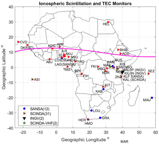
Figure 1. Distribution of GPS ionospheric scintillation and TEC monitors (GISTM) deployed by Boston College (USA) and US Air Force Research Laboratories in Africa (SCINDA 2007–2014) and by the South African National Space Agency (SANSA). The line running from the geographic longitude 10° is the geomagnetic meridian.
Table 1. GPS ionospheric scintillation and TEC monitors in Africa.
| Locations | Host Nation | Station Code | Network | Latitude | Longitude |
|---|---|---|---|---|---|
| Abidjan | Ivory Coast | ABJ | SCINDA | 5.34 | 5.36 |
| Addis Abeba | Ethiopia | ADD | SCINDA | 9.33 | 38.75 |
| Ascension Island | Atlantic Ocean | ASI | SCINDA | −7.98 | −14.41 |
| Bahir-Dar | Ethiopia | BHD | SCINDA | 11.57 | 37.39 |
| Brazzaville | Congo | BZV | SCINDA | −4.28 | 15.25 |
| Busitema | Uganda | BUS | SANSA | 0.75 | 34.04 |
| Butare | Rwanda | NUR | SCINDA | −2.61 | 29.74 |
| Cape Verde | Atlantic Ocean | CVD | SCINDA | 16.73 | −22.94 |
| Dakar | Senegal | DKR | SCINDA | 14.68 | −17.46 |
| Helwan | Egypt | HEL | SCINDA | 29.87 | 31.32 |
| Hermanus | South Africa | HMO | SCINDA | −34.42 | 19.22 |
| Ilorin | Nigeria | ILR | SCINDA | 8.48 | 4.67 |
| Kabwe | Zambia | KAB | SANSA | −14.44 | 28.46 |
| Kampala | Uganda | KAM | SCINDA | 0.37 | 32.56 |
| Kampala | Uganda | KMP | SCINDA-VHF | 0.37 | 32.56 |
| Kilifi | Kenya | KIL0N | INGV | −3.62 | 39.84 |
| Kilifi | Kenya | KAL | SANSA | −3.62 | 39.84 |
| Kinshasa | Congo | FIH | SCINDA | −4.42 | 15.31 |
| Kisangani | Congo | FKI | SCINDA | 0.51 | 25.21 |
| Kitwe | Zambia | KIT | SCINDA | −12.80 | 28.24 |
| Koudougou | Burkina Faso | KDG | SCINDA | 12.24 | −2.40 |
| Lagos | Nigeria | LOS | SCINDA | 6.52 | 3.39 |
| Lagos | Nigeria | LAG | SANSA | 6.52 | 3.39 |
| Malindi | Kenya | MAL0P | INGV | −2.93 | 40.21 |
| Maseno | Kenya | KIS | SCINDA | 0 | 34.6 |
| Mbarara | Uganda | MBQ | SCINDA | −0.62 | 30.65 |
| Nairobi (J K U) | Kenya | NBO | SCINDA | −1.09 | 37.02 |
| Nairobi (U of Nairobi) | Kenya | NR2 | SCINDA | −1.27 | 36.81 |
| Nairobi (U of Nairobi) | Kenya | NAI | SCINDA-VHF | −1.27 | 36.81 |
| Niamey | Niger | NIM | SCINDA | 13.50 | 2.10 |
| Nsukka | Nigeria | NSU | SCINDA | 6.86 | 7.41 |
| Sao Tome and Principe | Atlantic Ocean | TMS | SCINDA | 0.34 | 6.74 |
| Seychelles | Indian Ocean | SEZ | SCINDA | −4.32 | 55.69 |
| Yaounde | Cameroon | YAO | SCINDA | 3.90 | 11.50 |
| Zanzibar | Tanzania | ZNZ | SCINDA | −6.23 | 39.21 |
- (b)
-
Geodetic GNSS Receivers and GNSS reference receivers for surveying and mapping.
GNSS receivers have been deployed by several external parties (NASA, NOAA, ESA, BKG, and others) for geodetic studies of the African continent. Besides the GNSS receivers deployed by external parties, national mapping agencies in many African countries have installed GNSS reference receivers to support mapping and surveying work. Figure 2 shows the distribution of GNSS geodetic and reference receivers in and around Africa.
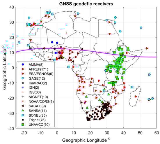
Figure 2. GNSS geodetic and reference receiver distribution. The purple line shows the location of the geomagnetic equator.
(b1) International Global Navigation Satellite Systems Service (IGS).
The IGS is a voluntary federation of many worldwide agencies (350) that pool resources and data from permanent GNSS stations (512 in 2023) to generate precise GNSS products. The International GNSS Service provides, on an openly available basis, the highest-quality GNSS data, products, and services in support of the terrestrial reference frame; Earth observation and research; PNT; and other applications that benefit science and society [15].
- (c)
-
GAGE/UNAVCO Network
The Geodetic Facility for the Advancement of Geoscience (GAGE, formerly UNAVCO, University NAVSTAR Consortium) is a non-profit university-governed consortium funded by the National Science Foundation (NSF) and The National Aeronautics and Space Administration (NASA). It provides technical support to scientists for geodesy, tectonic, and geophysical events and education. It is responsible for archiving and disseminating measurements in RINEX format. The main projects are for North America and the poles. However, for more than 20 years, UNAVCO has supported a project covering the African continent (‘AfricaArray’), with the installation of many GNSS receivers mainly around the East African Rift for a few months up to several years, which can be used for space weather research (Figure 3). The files are available on their site via ftp or web GUI [16].
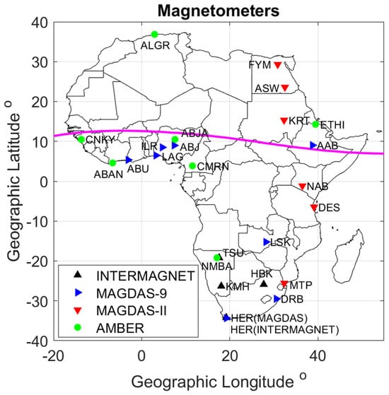
Figure 3. Locations of magnetometers of various networks in Africa. The purple line shows the location of the geomagnetic equator.
- (d)
-
The African Geodetic Reference Frame (AFREF)
The African Geodetic Reference Frame (AFREF) was conceived as a unified geodetic reference frame for Africa and as the fundamental basis for national and regional three-dimensional reference networks that are entirely consistent and homogeneous with the International Terrestrial Reference Frame (ITRF). Continuously Operating Reference Stations (CORS) or GNSS base stations were established to achieve this. The AFREF operational data center collects data daily. The data from all the stations of the IGS and GAGE networks are freely available on this website [17].
- (e)
-
The TRIGNET Network
The geodetic GNSS reference receivers of the TRIGNET network in South Africa are deployed and maintained by the South African Chief Directorate: National Geospatial Information (CD:NGI). This network of more than 60 GNSS receivers has provided South Africa with better GNSS infrastructure than the rest of the African countries. Data from the TRIGNET network is available via the web link of the Chief Directorate: National Geospatial Information (CD:NGI) [18].
SANSA (South African National Space Agency) recently deployed multi-constellation geodetic GNSS receivers for real-time ionospheric monitoring in South Africa (SUTG, 32.37° S, 20.81° E), in Southern Botswana (PALP, 22.60° S, 27.13° E; and LETL, 21.42° S, 25.57° E), in Zimbabwe (HARG, 17.78° S, 31.05° E), in Namibia (KMHG, 26.53° S, 18.1° E) and in Lagos, Nigeria (TSUG, 19.20° S,17.58° E).
- (f)
-
African Monsoon Multidisciplinary Analysis (AMMA) GPS Network [19]
The AMMA GNSS receivers were installed in Djougou (Benin), Niamey (Niger), Gao (Mali), Tamale (Ghana), Ouagadougou (Burkina-Faso), and Tombouctou (Mali) during the period 2006–2009. Although the data can be used across disciplines, these GNSS stations were established for meteorological applications, but the data can also be used for space weather studies and can be downloaded from the AFREF website.
- (g)
-
The CNES/SAGAIE network
CNES (France) began the implementation of the SAGAIE (Stations ASECNA GNSS pour l’Analyse de la Ionosphère Equatoriale) network in 2013 for the real-time correction of an extension of SBAS/EGNOS to Africa. The current network includes nine stations (Table 2), all installed at major airports, often with one geodesy receiver and one scintillator receiver at each station. Operational monitoring is carried out by ASECNA (Agence pour la Sécurité de la Navigation aérienne en Afrique et à Madagascar). Unfortunately, these data are not yet freely accessible [20].
Table 2. CNES/SAGAIE stations operating in 2023.
| Marker | Country | Latitude | Longitude |
|---|---|---|---|
| ABI1 | Ivory Coast | 5.32 | −4.03 |
| CTO1 | Benin | 6.37 | 2.39 |
| DAK2 | Senegal | 14.76 | −17.38 |
| NIA1 | Togo | 9.74 | 1.12 |
| LOM2 | Togo | 6.14 | 1.24 |
| NDJA | Chad | 12.12 | 15.06 |
| OUAG | Burkina Faso | 12.36 | −1.53 |
| DOUA | Cameroon | 4.05 | 9.71 |
| BAM1 | Mali | 12.65 | −8.00 |
- (h)
-
The SONEL network
SONEL (Système d’observation du Niveau des eaux Littorales) produces accurate sea level measurements from tide gauges and geodetic receivers. There are more than 1000 GNSS stations near the coasts around the world, but only a few dozen around the African continent. The measurements are available on their website [21].
- (i)
-
CORS and Private Networks
There are many CORS networks in several African countries. Unfortunately, their advertising is limited, so it is very difficult to establish a list of operational stations in each. Those responsible do not offer web links, and the measurements taken are unfortunately inaccessible. Two exceptions can be cited:
The NOAA/CORS network in Benin included 7 stations (BJKA, BJNA, BJNI, BJPA, BJSA, BJAB, BJCO). The network was shut down in January 2020.
The NIGNET network (Nigerian GNSS Reference Network) in Nigeria. It included up to 14 stations distributed in each region (BKFP, HUKP, MDGR, RECT, FPNO, ABUZ, CGGT, FUTY, OSGF, ULAG, UNEC, RUST, CLBR, GEMB). The measurements were used for geodesy, troposphere, and ionosphere. The network was shut down in 2017. The data of these two networks are available on the AFREF website.
- (j)
-
OMNISTAR Differential GNSS
OmniSTAR provides GNSS receivers for their space-based GNSS correction services that can improve the accuracy of precise positioning applications. The OMNISTAR (Trimble Private Network) GPS receivers are mainly deployed along the African coast to improve the accuracy of GPS positioning for ocean navigation, but they are still useful for space weather studies. OMNISTAR is a private commercial network of satellite-based augmentation services. The data from this network are not freely available [22].
2.1.2. Magnetometers in Africa
Magnetometers are ground-based infrastructure used in space weather monitoring for monitoring the impact of geomagnetic storms. Figure 3 and Table 3, Table 4, Table 5 and Table 6 provide the locations and other details of the magnetometers in Africa.
Table 3. AMBER magnetometer stations in Africa.
| Station and Host Country | Code | Geo Lat/ Geo Lon |
Mag Lat/ Mag Lon |
L-Shell Value |
|---|---|---|---|---|
| Medea Station Algeria | ALGR | 36.85 2.93 |
27.98 77.67 |
1.30 |
| Yaounde Station Cameroon | CMRN | 3.87 11.52 |
−5.30 83.12 |
1.00 |
| Abidjan Station Côte d’Ivoire | ABAN | 4.60 −6.60 |
−6.00 65.80 |
1.00 |
| Adigrat Station Ethiopia | ETHI | 14.28 39.46 |
5.90 111.06 |
1.00 |
| Conakry Station Guinea | CNKY | 10.50 −13.70 |
−0.50 60.40 |
1.00 |
| Windhoek Station Namibia | NMBA | −19.20 17.09 |
−33.15 84.65 |
1.40 |
| Abuja Station Nigeria | ABJA | 10.50 7.55 |
0.55 79.63 |
1.00 |
Table 4. AMBER network host institutions and contact persons.
| Name | Organization | Email Address |
|---|---|---|
| Fatma Anad | Centre de Recherche en Astronomie Astrophysique et Géophysique (CRAAG), Algeria | f_anad@yahoo.fr |
| Cesar Biouele PhD. | University of Yaounde I, Cameroon | cesar.mbane@yahoo.fr |
| Amoré Nel, PhD | South African National Space Agency (SANSA), Hermanus, South Africa | anel@sansa.org.za |
| Alem Mebrahtu PhD. | Adigrat University, Ethiopia | alemmeb@yahoo.com |
| Rabiu Babatunde, PhD. | Centre for Atmospheric Science, National Space Research and Development, Nigeria | tunderabiu@yahoo.com |
Table 5. Magnetometers installed in Africa by Kyushu University, Japan. The geomagnetic dipole coordinates are determined using model calculations provided by the British Geological Survey—Geomagnetism (https://www.bgs.ac.uk/?s=coordinate+calculator, accessed on 26 November 2023) The geomagnetic coordinates and the dip latitude were calculated using the BGS online IGRF model (https://geomag.bgs.ac.uk/data_service/models_compass/igrf_calc.html, accessed on 26 November 2023).
| Abbrev. | Station Name | Nation | GG Lat. | GG Lon. | GM Lat. | GM Lon. | L-Shell | Dip Lat. | Installed | Type |
|---|---|---|---|---|---|---|---|---|---|---|
| FYM | Fayum | Egypt | 29.30 | 30.88 | 26.76 | 103.64 | 1.15 | 43.68 | 08/01/14 | MAGDAS-II |
| ASW | Aswan | Egypt | 23.59 | 32.51 | 20.88 | 108.75 | 1.07 | 33.98 | 08/12/23 | MAGDAS-II |
| KRT | Khartoum | Sudan | 15.33 | 32.32 | 12.76 | 107.18 | 1.01 | 16.30 | 08/09/23 | MAGDAS-II |
| AAB | Addis Ababa | Ethiopia | 9.04 | 38.77 | 5.56 | 112.51 | 1.00 | 3.39 | 06/08/19 | MAGDAS-9 |
| ILR | Ilorin | Nigeria | 8.50 | 4.68 | 10.42 | 78.83 | 1.00 | −8.44 | 06/08/24 | MAGDAS-9 |
| ABU | Abuja | Nigeria | 8.99 | 7.39 | 10.48 | 81.60 | 1.00 | −6.75 | 10/08/15 | MAGDAS-9 |
| LAG | Lagos | Nigeria | 6.48 | 3.27 | 8.65 | 77.11 | 1.00 | −13.91 | 08/09/04 | MAGDAS-9 |
| ABJ | Abidjan | Ivory Coast | 5.35 | −3.08 | 8.52 | 70.62 | 1.00 | −17.41 | 06/09/01 | MAGDAS−9 |
| NAB | Nairobi | Kenya | −1.16 | 36.48 | −4.18 | 108.73 | 1.09 | −22.36 | 08/09/16 | MAGDAS-II |
| DES | Dar Es Salaam | Tanzania | −6.47 | 39.12 | −9.83 | 110.54 | 1.09 | −33.10 | 08/09/10 | MAGDAS-II |
| LSK | Lusaka | Zambia | −15.23 | 28.20 | −16.78 | 98.25 | 1.24 | −52.48 | 08/09/25 | MAGDAS-9 |
| MPT | Maputo | Mozambique | −25.57 | 32.36 | −27.63 | 100.52 | 1.53 | −60.40 | 08/09/15 | MAGDAS-II |
| DRB | Durban | South Africa | −29.49 | 30.56 | −31.20 | 97.92 | 1.67 | −62.05 | 08/09/08 | MAGDAS-9 |
| HER | Hermanus | South Africa | −34.34 | 19.24 | −34.14 | 85.64 | 1.83 | −64.74 | 07/09/14 | MAGDAS-9 |
Table 6. MAGDAS magnetometer station host countries and their universities.
| Station Code | Station Name | Country | Institution |
|---|---|---|---|
| ABJ | Abidjan | Ivory Coast | University of Cocody |
| LAG | Lagos | Nigeria | Redeemer’s University |
| ILR | Ilorin | Nigeria | University of Ilorin |
| ABU | Abuja | Nigeria | National Space Research and Development Agency |
| AAB | Addis Ababa | Ethiopia | Addis Ababa University |
| HER | Hermanus | South Africa | SANSA Space Science |
| DRB | Durban | South Africa | University of KwaZulu Natal |
| MTP | Maputo | Mozambique | Eduardo Mondlane University |
| LSK | Lusaka | Zambia | University of Zambia |
| DES | Dar es Salaam | Tanzania | University of Dar es Salaam |
| NAB | Nairobi | Kenya | University of Nairobi |
| KRT | Khartoum | Sudan | University of Khartoum |
| ASW | Aswan | Egypt | Helwan University |
| FYM | Fayum | Egypt | Helwan University |
- (a)
The African Meridian B-field Education and Research (AMBER) magnetometer network is operated by Boston College and funded by NASA and the Air Force Office of Scientific Research (AFOSR). The principal investigators are Endawoke Yizengaw, PhD. (Ethiopia), Boston College, USA and Mark Moldwin, PhD, University of Michigan, USA (http://magnetometers.bc.edu/index.php/amber2, accessed on 26 November 2023). The AMBER stations in Africa are Adigrat (Ethiopia), Medea (Algeria), Yaounde (Cameroon), Tsumeb (Namibia), Abuja (Nigeria), Conakry (Guinea), and Abidjan (Ivory Coast).
- (b)
The principal investigator (PI) of the project which installed these magnetometers was Prof. Kiyohumi Yumoto (deceased) of the International Center for Space Weather Science and Education (ICSWSE), Kyushu University, Japan. ICSWSE, Kyushu University, is one of the few research institutes/universities conducting research and education in space weather in the world. The MAGDAS network has over seventy fluxgate magnetometers distributed across the world, with 14 of them installed in Africa. The MADGAS data have been used by several researchers in Africa for space weather research, but quite a number of these magnetometers are no longer operational.
- (c)
-
INTERMAGNET
INTERMAGNET is a global network of observatories dedicated to monitoring geomagnetic field variations across the world. There are INTERMAGNET magnetometers in five countries in Africa, namely Ethiopia, Madagascar, South Africa, Algeria, and Senegal. Details of the four INTERMAGNET observatories and other magnetometers in Southern Africa can be found in [34][35][36][37][38]. At each of the four INTERMAGNET observatories in Southern Africa, there are several types of magnetometers, including Overhauser Scalar Magnetometer GSM-90, 3-axis Fluxgate Magnetometers DMI FGE, and 3-axis Fluxgate Magnetometers LEMI025.
2.1.3. Other Ground-Based Facilities
Several other ground-based facilities that can be used for space weather monitoring have been deployed in Africa. Figure 4 depicts the distribution of most of the other space weather equipment in Africa.
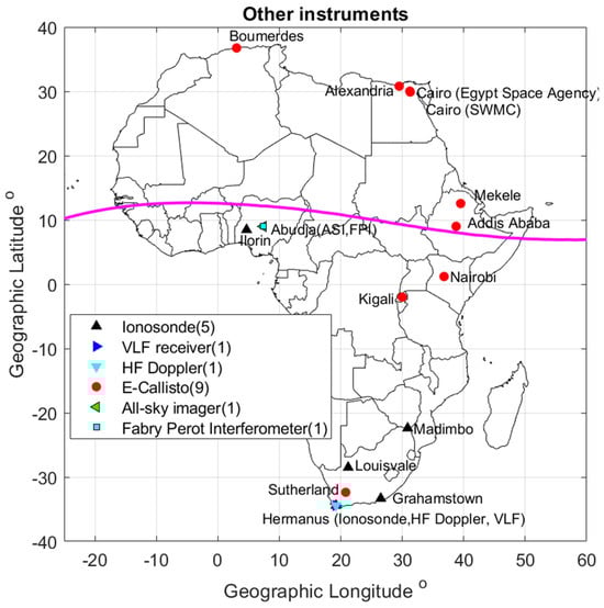
Figure 4. Distribution of other infrastructure dedicated to space weather monitoring in Africa.
- (a)
-
Incoherent Scatter Radars
The incoherent scatter radar (ISR) is one of the most powerful sounding methods developed to estimate certain properties of the ionosphere. This radar system determines the plasma parameters by sending powerful electromagnetic pulses to the ionosphere and analyzing the received backscatter. This analysis provides information about parameters such as electron and ion temperatures, electron densities, ion composition, and ion drift velocities. Nevertheless, in some cases, ISR analysis has ambiguities in the determination of plasma characteristics. They are in Ethiopia and Nigeria. There is also one under construction in Kenya.
- (b)
-
Ionosondes
The ionosondes are used to generate ionograms and assist in determining the state of the ionosphere and selecting the optimum frequencies for HF radio communication.
The ionosondes are installed in South Africa (four), Kenya (one), Ethiopia (one), and Nigeria (one). The stations in Kenya, Ethiopia, and Nigeria are non-operational. In the Ethiopian case, the electric power supply is unreliable and unstable, and in the Kenyan case, there are issues with system configuration as well as storage of data. Only two of the ionosondes in South Africa are currently operational (HR, GR), while the two others are being refurbished after vandalism and theft.
A new ionosonde was installed in July 2023 in Malindi, Kenya, at the Broglio Space Center (BSC) managed by the Italian Space Agency and it is the only one operational, at present, outside South Africa.
- (c)
-
Very-Low-Frequency (VLF) and Very-High-Frequency (VHF) receivers
Several VLF devices have been distributed by Stanford University (USA) and installed in several African countries (See Table 7) to monitor the lower layer of the ionosphere (D layer). They are divided into two groups: those related to the AWESOME (Atmospheric Weather Education System for Observation and Modeling of Effects) network and those related to the SID (Sudden Ionospheric Disturbance Monitor) and super-SID receivers. Besides these, there is also the Compact Astronomical Low-Cost Low-Frequency Instrument for Spectroscopy and Transportable Observatory (CALLISTO) spectrometer [39][40], which operates between 45 to 870 MHz. The monitors are installed in Kenya, Ethiopia, Uganda, Egypt, Algeria, and South Africa. The principal investigator of CALLISTO is Christian Monstein of the Radio Astronomy Group (RAG) at ETH Zurich, Switzerland. SANSA operates an e-Callisto Solar Radio Spectrometer (http://e-callisto.org/) at Sutherland in South Africa (Lat 32:38° S, Lon 20:81° E). Table 7 gives some details of the VLF and VHF receivers installed in Africa.
Table 7. The number of VLF and VHF receivers installed.
| Countries | AWESOME | VHF | SID |
|---|---|---|---|
| Algeria | 1 | 0 | 2 |
| Burkina Faso | 0 | 0 | 1 |
| Congo Brazzaville | 0 | 0 | 6 |
| Ivory Coast | 0 | 2 | 2 |
| Egypt | 1 | 2 | 14 |
| Ethiopia | 1 | 2 | 14 |
| Kenya | 0 | 2 | 3 |
| Libya | 2 | 0 | 1 |
| Morocco | 1 | 0 | 0 |
| Namibia | 0 | 0 | 1 |
| Nigeria | 0 | 2 | 38 |
| Senegal | 0 | 0 | 1 |
| South Africa | 0 | 2 | 13 |
| Tunisia | 1 | 0 | 9 |
| Uganda | 0 | 2 | 4 |
| Zambia | 0 | 0 | 2 |
Some VHF monitors [11] were installed across the continent by AFRL. The host countries are Congo (Brazzaville), Egypt, Ethiopia, Kenya, Nigeria, South Africa, and Uganda.
Most of North Africa and parts of Central Africa have substantial infrastructure gaps. Several countries in these regions are politically unstable, thus making the installation of ground-based space weather equipment rather difficult. These gaps will need to be filled so that there will be sufficient data to enable adequate coverage of Africa in terms of space weather research.
2.2. Data Access and Reliability
Most of the data generated by the observing equipment have a free access policy, except for those owned by national mapping agencies in various countries. However, different data providers have imposed conditions to be met before granting access to the data. In most cases, if the data is purely for research, and not for commercial use, then free access is always granted, but some acknowledgement of the data source is required whenever a publication is produced with them. The SANDIMS data portal at SANSA [41] provides free access, via a data request for research applications, to all geomagnetic, ionospheric, and magnetospheric data gathered from SANSA Space Science’s instrumentation network. The eSWua web portal of Istituto Nazionale di Geofisica e Vulcanologia (INGV) in Italy [42] provides free access to visualization and downloads of the data from instruments managed by INGV. The users can access data from a GUI or a service from which massive data downloading can be performed automatically.
This open data policy has enabled many African researchers to benefit from space weather data generated by equipment hosted in the continent and beyond. In effect, this has contributed immensely to human capital development in space weather science in many countries in Africa. However, a major setback is the non-operational status of most of the equipment due to several factors such as non-stable electric power supply, poor internet connectivity, poor system configuration, poor maintenance, and equipment operating beyond its useful lifetime. Replacement of ageing equipment and maintenance issues are made worse by the fact that some African equipment hosts do not actually use the data for any training or research and hence have no interest in maintaining or replacing the equipment. Although some of the factors limiting successful equipment functioning could be addressed by the hosts (e.g., unreliable electric power by investing in solar power), most of the equipment hosts do not have funding for this, and most of the host institutions do not provide support towards that end.
The lack of a good network of space weather monitors in Africa is limiting the modelling of the African sector of the near-earth space environment and thus the development of space weather products and services. For example, it is known that scintillation threatens the performances of GNSS-reliant services requiring high-precision positioning, but forecasting scintillation is still a challenge. The development of ionospheric climatology over various geographic regions of Africa would be a useful step in providing space weather information. Climatology is only possible with a proper network of space weather monitors that continuously provide data over an extended period.
2.3. Space Weather Products and Services
There is a need to develop thresholds of space weather threats on a variety of technological systems in Africa. This includes the aviation industry since ICAO now recommends the provision of space weather alerts as part of regulations and standards for enhanced safety in civil aviation. Except for SANSA Space Science in South Africa, the rest of Africa has not developed space weather products and services for the aviation industry and other industrial sectors. Commercialization of space weather research findings will help mitigate economic losses brought about by space weather events, and it could also possibly provide funding streams to support space weather research. At the moment, there is a huge disconnect between industry and academia in Africa.
References
- Knipp, D.D. Understanding Space Weather and the Physics Behind It; The McGraw-Hill Companies Inc.: New York, NY, USA, 2011; ISBN 13-978-0-07-340890-3.
- Available online: https://cddis.nasa.gov/Data_and_Derived_Products/GNSS/GNSS_data_and_product_archive.html (accessed on 26 November 2023).
- Gaunt, C.T.; Coetzee, G. Transformer failures in regions incorrectly considered to have low GIC-risk. In Proceedings of the IEEE Lausanne Power Tech Conference, Lausanne, Switzerland, 1–5 July 2007.
- Institute for Scientific Research, Boston College, USA. Available online: https://www.bc.edu/content/bc-web/research/sites/institute-for-scientific-research/research/space-weather.html (accessed on 26 November 2023).
- Akala, A.O.; Amaeshi, L.I.N.; Somoye, E.O.; Idolor, R.O.; Okoro, E.; Doherty, P.H.; Groves, K.M.; Bridgewood, C.T.; Baki, P.; D’Ujanga, F.M.; et al. Climatology of GPS Scintillations Over Equatorial Africa during the minimum and Ascending Phases of Solar Cycle 24. Astrophys. Space Sci. 2019, 17, 357.
- Omondi, G.E.; Baki, P.; Ndinya, B.O. Total electron content and scintillations over Maseno, Kenya, during high solar activity year. Acta Geophys. 2019, 67, 1661–1670.
- Paznukhov, V.V.; Carrano, C.S.; Doherty, P.H.; Groves, K.M.; Caton, R.G.; Valladares, C.E.; Seemala, G.K.; Bridgwood, C.T.; Adeniyi, J.J.; Amaeshi, L.L.; et al. Equatorial plasma bubbles and L-band scintillations in Africa during solar minimum. Annales Geophys. 2012, 30, 675–682.
- Olwendo, O.J.; Baki, P.; Mito, C.; Doherty, P. Elimination of Superimposed Multipath effects on Scintillation Index on Solar Quiet Ionosphere at Low latitude using a single SCINDA-GPS receiver. In Proceedings of the 23rd International Technical Meeting of the Satellite Division of The Institute of Navigation (ION GNSS 2010), Portland, OR, USA, 21–24 September 2010; pp. 386–392.
- Olwendo, O.J.; Baki, P.; Cilliers, P.J.; Mito, C. Using GPS-SCINDA Observations to study the correlation between Scintillation, Total Electron Content Enhancement and Depletions over the Kenyan Region. Adv. Space Res. 2012, 49, 1363–1372.
- D’Ujanga, F.M.; Baki, P.; Olwendo, O.J.; Twinamasiko, B.F. Total Electron Content of the Ionosphere at two stations in East Africa during the 24–25 October 2011 Geomagnetic storm. Adv. Space Res. 2013, 51, 712–721.
- Olwendo, J.; Baluku, T.; Baki, P.; Cilliers, P.J.; Mito, C.; Doherty, P. Low Latitude Ionospheric Scintillation and ionospheric Irregularity Drifts observations with SCINDA_GPS and VHF receivers in Kenya. Adv. Space Res. 2013, 51, 1715–1726.
- Ngwira, C.M.; Lenzing, J.; Olwendo, J.; D’Ujanga, F.M.; Baki, P. A Study of Intense Ionospheric Scintillation Observed During a Quiet Day in the East African Low Latitude Region. Radio Sci. 2013, 48, 1–10.
- Kahindo, B.M.; Kazadi Mukenga Bantu, A.; Fleury, R.; Zana, A.T.K.; Ndontoni, Z.; Kakule Kaniki, M.; Amory-Mazaudier, C.; Groves, K. Contribution à l’étude de la scintillation ionosphérique équatoriale surla crête sud de l’Afrique. J. Sci. 2017, 17, 27–47.
- Mahrous, A.; Ibrahim, M.; Makram, I.; Berdermann, J.; Salah, H.M. Ionospheric scintillations detected by SCINDA-Helwan station during St. Patrick’s Day geomagnetic storm. NRIAG J. Astron. Geophys. 2018, 7, 214–219.
- IGS. Available online: https://igs.org/network/ (accessed on 26 November 2023).
- GAGE/UNAVCO. Available online: https://www.unavco.org/what-we-do/gage-facility/ (accessed on 26 November 2023).
- AFREF. Available online: http://afrefdata.org/ (accessed on 26 November 2023).
- TRIGNET. Available online: http://www.trignet.co.za/ (accessed on 26 November 2023).
- AMMA. Available online: https://grgs.obs-mip.fr/recherche/projets/amma/ (accessed on 26 November 2023).
- SAGAIE. Available online: Ftp://regina-public-sef.cnes.fr/Niveau0/SAGAIE/pub (accessed on 26 November 2023).
- SONEL. Available online: https://www.sonel.org/-GPS-.html?lang=en (accessed on 26 November 2023).
- OMNISTAR. Available online: https://www.omnistar.com/about-us/ (accessed on 26 November 2023).
- Magnetometers Data Center. Available online: http://magnetometers.bc.edu/index.php/amber2 (accessed on 26 November 2023).
- Anad, F.; Amory-Mazaudier, C.; Hamoudi, M.; Bourouis, S.; Abtout, A.; Yizengaw, E. Sq solar variation at Médéa Observatory (Algeria), from 2008 to 2011. Adv. Space Res. 2016, 58, 1682–1695.
- Honore, M.E.; Anad, F.; Ngabireng, M.C.; Mbane, B.C. Sq (H) Solar Variation at Yaoundé-Came-roon AMBER Station from 2011 to 2014. Int. J. Geosci. 2017, 8, 545–562.
- Honore, M.E.; Kosh, D.; Mbané, B.C. Day-to-Day Variability of H Component of Geomagnetic Field in Central African Sector Provided by Yaoundé-Cameroon Amber Station. Int. J. Geosci. 2014, 5, 1190–1205.
- Available online: http://magdas2.serc.kyushu-u.ac.jp/station/index.html (accessed on 26 November 2023).
- Takla, E.M.; Yumoto, K.; Cardinal, M.G.; Abe, S.; Fujimoto, A.; Ikeda, A.; Tokunaga, T.; Yamazaki, Y.; Uo-zumi, T.; Mahrous, A.; et al. A study of latitudinal dependence of Pc 3-4 amplitudes at 96º magnetic meridian stations in Africa. Sun Geosph. 2011, 6, 67–72.
- Omondi, G.E.; Baki, P.; Ndinya, B.O. Quiet time correlation between the Geomagnetic Field variations and the Dynamics of the East African equatorial ionosphere. Int. J. Astrophys. Space Sci. 2017, 5, 6–18.
- Hawary, R.E.; Yumoto, K.K.; Mahrous, A.; Ghamry, E.; Meloni, A.; Badi, K.; Kianji, G.; Uiso, S.C.B.; Mwiinga, N.; Jao, L.L.; et al. Annual and semi-annual Sq variations at 96° MM MAGDAS I and II stations in Africa. Earth Planets Space 2012, 66, 425–432.
- Shimeis, A.; Fathy, I.; Amory-Mazaudier, C.; Fleury, R.; Mahrous, A.M.; Yumoto, K.; Groves, K. Signature of the Coronal Hole on near the North Crest Equatorial Anomaly over Egypt during the strong Geomagnetic Storm 5th April 2010. J. Geophys. Res. Space Phys. 2012, 117, A07309.
- Honore, M.E.; Amaechi, P.O.; Daika, A.; Aziz, D.K.A.; Kaab, M.; Mbane, C.B.; Benkhaldoun, Z. Longitudinal Variability of the Vertical Drift Velocity Inferred from Ground-Based Magnetometers and C/NOFS Observations in Africa. Int. J. Geosci. 2022, 3, 657–680.
- Omondi, S.; Akimasa, Y.; Waheed, K.Z.; Fathy, I.; Ayman, M. Alex magnetometer and telluric station in Egypt: First results on pulsation analysis. Adv. Space Res. 2022, 72, 711–725.
- Kauristie, K.; Andries, J.; Beck, P.; Berdermann, J.; Berghmans, D.; Cesaroni, C.; De Donder, E.; de Patoul, J.; Dierckxsens, M.; Doornbos, E.; et al. Space Weather Services for Civil Aviation—Challenges and Solutions. Remote Sens. 2021, 13, 3685.
- Intermagnet. Available online: https://www.intermagnet.org/imos/imotblobs-eng.php (accessed on 26 November 2023).
- Zaourar, N.; Amory-Mazaudier, C.; Fleury, R. Hemispheric asymmetries in the ionosphere response observed during the high-speed solar wind streams of the 24–28 August 2010. Adv. Space Res. 2017, 59, 2229–2247.
- Kotzé, P.B.; Cilliers, P.J.; Sutcliffe, P.R. The role of SANSA’s geomagnetic observation network in space weather monitoring: A review. Space Weather 2015, 13, 656–664.
- Nahayo, E.; Kotzé, P.B.; Cilliers, P.J.; Lotz, S. Observations from SANSA’s geomagnetic network during the Saint Patrick’s Day storm of 17–18 March 2015. S. Afr. J. Sci. 2019, 115, 5204.
- CALLISTO Data. Available online: http://e-callisto.org/ (accessed on 26 November 2023).
- Minta, F.N.; Nozawa, S.I.; Kozarev, K.; Elsaid, A.; Mahrous, A.A. Solar radio bursts observations by Egypt-Alexandria CALLISTO spectrometer: First results. Adv. Space Res. 2022, 72, 844–853.
- SANDMIS Data. Available online: https://sandims.sansa.org.za/ (accessed on 26 November 2023).
- INGV Data. Available online: http://www.eswua.ingv.it/ (accessed on 26 November 2023).
More
Information
Subjects:
Physics, Fluids & Plasmas
Contributors
MDPI registered users' name will be linked to their SciProfiles pages. To register with us, please refer to https://encyclopedia.pub/register
:
View Times:
933
Revisions:
2 times
(View History)
Update Date:
18 Dec 2023
Table of Contents


Notice
You are not a member of the advisory board for this topic. If you want to update advisory board member profile, please contact office@encyclopedia.pub.
OK
Confirm
Only members of the Encyclopedia advisory board for this topic are allowed to note entries. Would you like to become an advisory board member of the Encyclopedia?
Yes
No
${ textCharacter }/${ maxCharacter }
Submit
Cancel
Back
Comments
${ item }
|
${ item.createdUser.fullName }
${ item.createdAt }
${ item.vote }
${ item.reply }
Delete
${ reply.createdUser.fullName }
${ reply.createdAt }
${ reply.vote }
Delete
There is no reply to this comment~
${ item.replyTextCharacter }/${ item.replyMaxCharacter }
Submit
Cancel
More
No more~
There is no comment~
${ textCharacter }/${ maxCharacter }
Submit
Cancel
${ selectedItem.replyTextCharacter }/${ selectedItem.replyMaxCharacter }
Submit
Cancel
Confirm
Are you sure to Delete?
Yes
No