Submitted Successfully!
To reward your contribution, here is a gift for you: A free trial for our video production service.
Thank you for your contribution! You can also upload a video entry or images related to this topic.
Version Summary Created by Modification Content Size Created at Operation
1 -- 1550 2023-12-15 16:15:20 |
2 layout Meta information modification 1550 2023-12-18 04:13:11 |

Video Upload Options

Do you have a full video?

Confirm

Are you sure to Delete?
Cite
If you have any further questions, please contact Encyclopedia Editorial Office.
Yang, Y.; Yeh, H.; Huang, C.; Chen, H. Hillslope Hydrology and Stability in Taiwan. Encyclopedia. Available online: https://encyclopedia.pub/entry/52818 (accessed on 29 April 2024).
Yang Y, Yeh H, Huang C, Chen H. Hillslope Hydrology and Stability in Taiwan. Encyclopedia. Available at: https://encyclopedia.pub/entry/52818. Accessed April 29, 2024.
Yang, Ya-Sin, Hsin-Fu Yeh, Chia-Chi Huang, Hsin-Yu Chen. "Hillslope Hydrology and Stability in Taiwan" Encyclopedia, https://encyclopedia.pub/entry/52818 (accessed April 29, 2024).
Yang, Y., Yeh, H., Huang, C., & Chen, H. (2023, December 15). Hillslope Hydrology and Stability in Taiwan. In Encyclopedia. https://encyclopedia.pub/entry/52818
Yang, Ya-Sin, et al. "Hillslope Hydrology and Stability in Taiwan." Encyclopedia. Web. 15 December, 2023.
Hillslope Hydrology and Stability in Taiwan
Edit

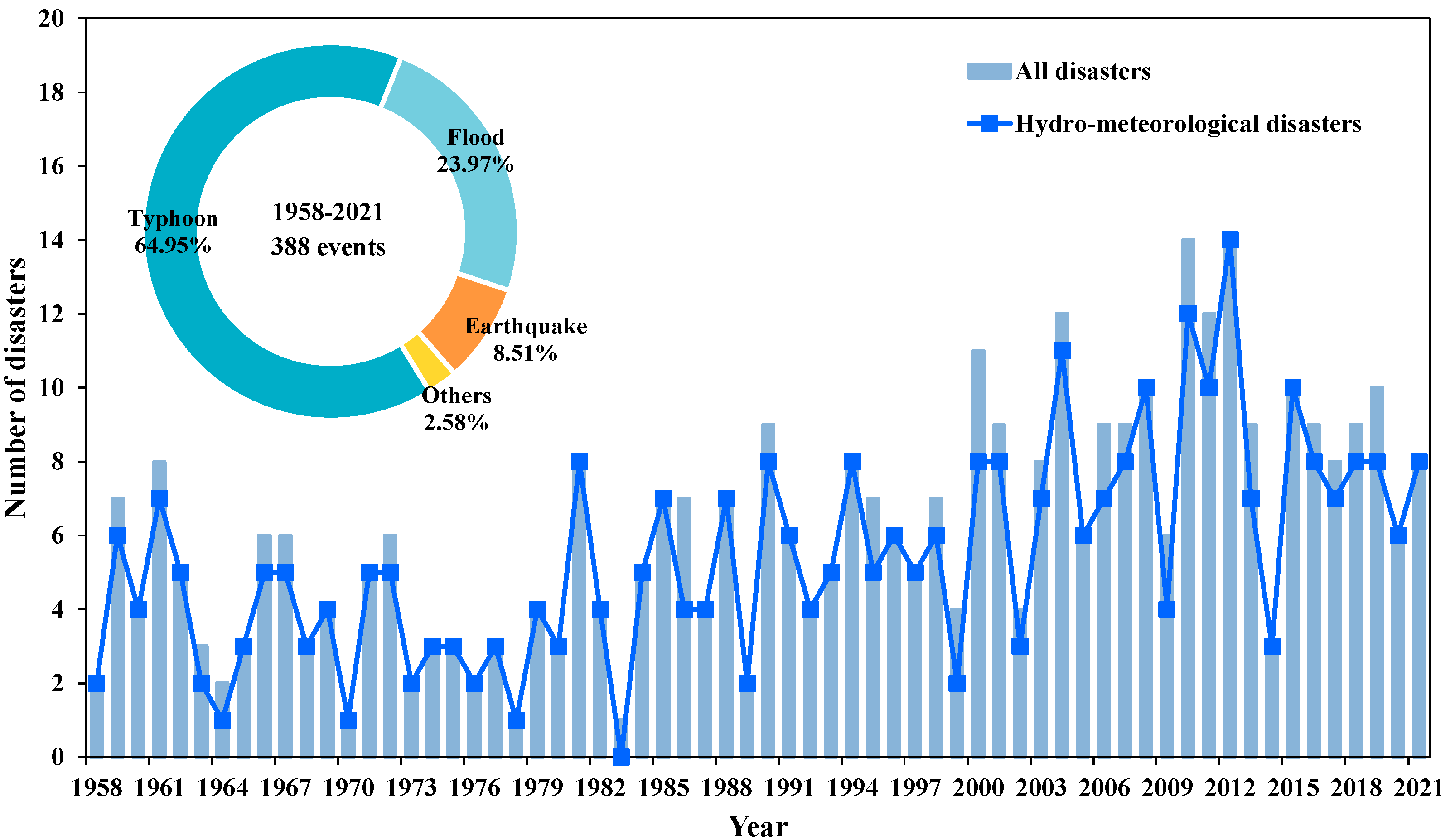
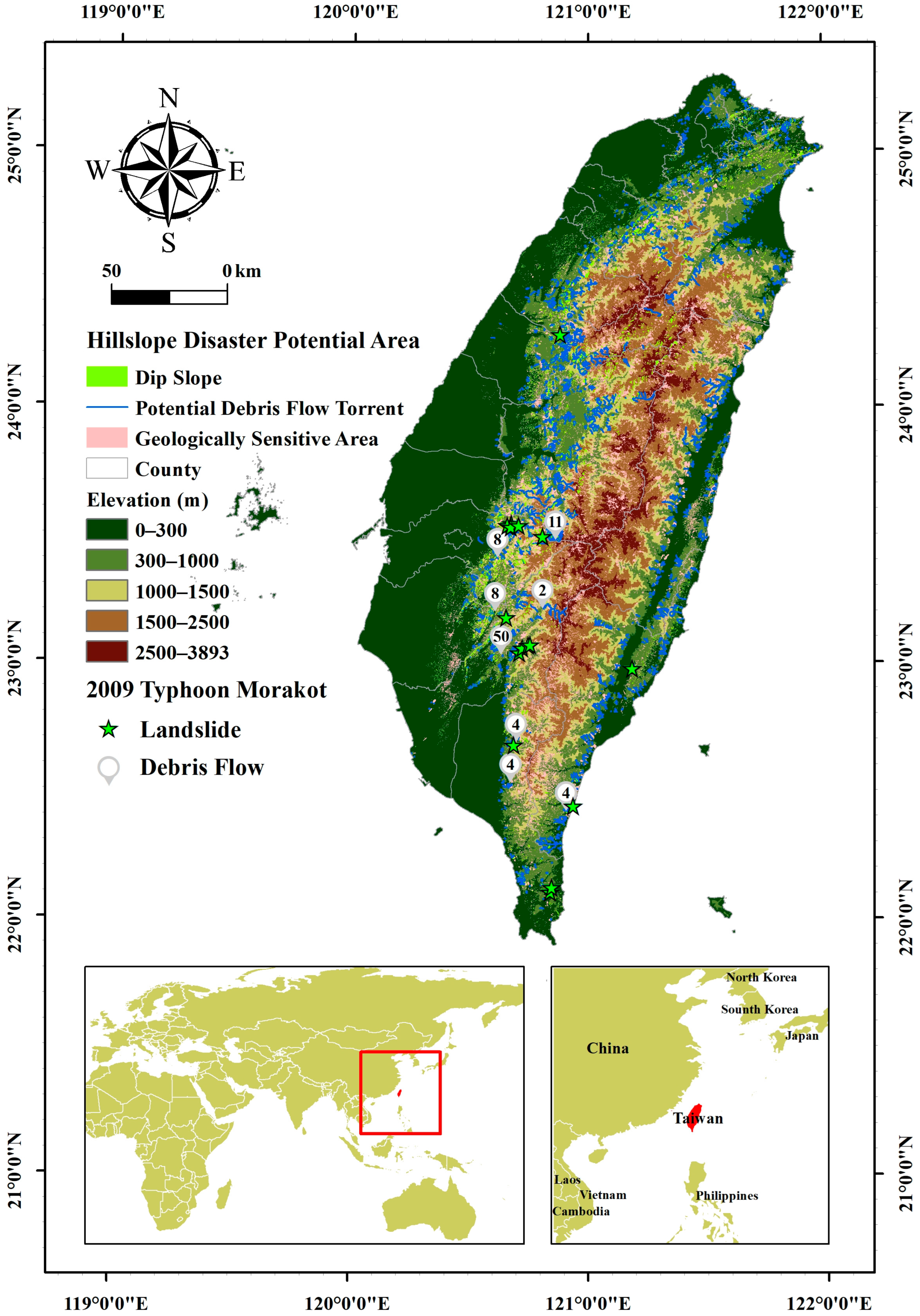
Owing to active orogenic movement and the monsoon climate, rainfall-induced landslide disasters often occur in Taiwan. Hence, hillslope hydrology and stability have received considerable research attention. However, it remains difficult to accurately estimate the duration and consequences of hillslope instability induced by hillslope hydrology. Research on hillslope hydrology and stability is complicated by spatial heterogeneity, hydrological processes operating at various scales, spatiotemporal evolution, and geomorphological properties. Recent advances in critical zone science have provided an approach to extend geoscience studies. The “deep coupling” concept is essential for integrating physical, chemical, and biological processes on various spatiotemporal scales and for providing a macro and unified framework for evaluating internal properties and processes.

hillslope hydrology critical zone science landslide slope stability

1. Introduction

Taiwan is located at the junction of the Eurasian and Philippine Sea plates, and due to intense orogenic movement, approximately 70% of its surface is covered with sloping fields. Disasters such as landslides and debris flows [1][2] are frequently brought on by rain, endangering both human life and property. As a result, numerous studies on hillslope hydrology and stability have been conducted in Taiwan. These include research on the susceptibility map of rainfall-induced landslides [3][4][5][6], the correlation between rainfall and landslide erosion [7][8], the relationship between landslide size and rainfall characteristics [9][10][11], the use of soil moisture as an early warning signal for landslides [12], and the relationship between the development of soil–rock interface saturation and shallow collapse [13]. For various reasons (the complex geologic structure, monsoon climate, and rapid erosion in Taiwan), it remains challenging to evaluate the mechanism, timings, and effects of hillslope instability induced by hillslope hydrology.
Hillslope hydrology and stability are affected locally by tectonic, lithological, geomorphic, weathering, vegetational, and bioturbation processes as well as by spatiotemporal climatic pressures [14]. These mechanisms interact with one another and contribute to the formation and propagation of hillslope instability. Hillslope failure as a natural geomorphic process is a crucial component of the dynamic earth surface environment at different scales, from earth surface processes to deep landslides, and occurs across a variety of time frames [15]. Anthropogenic activities exacerbate these large-scale processes [16]. As a result, the research on hillslope hydrology and stability is interdisciplinary and examines the transfer and storage of water, the generation of earth surface pressure, and local instability and movement of hillslopes caused by hydrological events [17][18][19]. Triggering factors are the key to hillslope failure, but the causes of hillslope failure may be found in the combined effect of flows and fluxes of different scales, as well as in long-standing potential changes [20]. Understanding the relationship between the Earth’s surface and subsurface processes is possible by the groundbreaking interdisciplinary subject known as critical zone science [21]. A critical zone is a heterogeneous, near-surface environment where complex interactions between rocks, soil, water, air, and living organisms maintain natural habitats and ensure the sustainability of living resources [22]. The “critical zone” concept was proposed to understand the earth’s shallow subsurface environment and examine the exchange of materials and energy interacting with, and sustaining, living things between the earth’s surface and subsurface, and focuses on a series of interconnected processes (such as rock weathering, soil formation, soil erosion, transportation and sedimentation, and geochemical action of water and soil) [23][24]. An interdisciplinary approach is used in critical zone studies to address the interrelated environmental issues that are relevant to several disciplines. The evolution of critical zones is closely related to human society, and the co-evolution of physical and biological systems can be investigated based on social needs combined with the critical zone perspective [25], increasing the social benefits produced by ecosystem services and understanding the supply chain concepts that emerge between them.

2. Background of Hillslope Hydrology and Stability in Taiwan

Taiwan is located at the junction of the Eurasian and Philippine Sea plates. The Philippine Sea plate was subducted under the Eurasian plate to cause active orogenic movement on the surface with an uplift rate of approximately 5–7 mm per year [26][27]. Approximately 31% of the total area of Taiwan is made up of mountainous regions with an altitude of more than 1000 m, 40% is made up of hilly areas and tablelands with an altitude of 100–1000 m, and 29% is made up of plain areas with an altitude of less than 100 m. Hillslope areas account for approximately 70% of Taiwan’s total land area. Taiwan stretches from 120° to 122° east longitude and from 22° to 25° north latitude and is dominated by a monsoon climate. The average annual rainfall is about 2500 mm, but it may be higher in mountainous areas [28]. Rainfall is influenced by the northeast monsoon during the cold season (September–April) and by the southwest monsoon during the warm season (May–August). Taiwan is situated in the path of the northwest Pacific typhoon, and typhoons frequently affect Taiwan in summer, causing intense rain. Furthermore, local afternoon showers caused by terrain and thermal convection currents are also common. The characteristic rainfall of Taiwan is usually generated either by transient subsynoptic disturbances or localized showers related to terrain or local winds [29]. From the perspective of rainfall sources, the season can be divided into winter (December–January), spring rains (February–April), May-yu season (May–June), typhoon season (July–September), and autumn (October–November). Winter is the season with the least rainfall, with an average daily rainfall of about 3 mm. Spring rainfall increases slightly, at about 5 mm per day. May-yu season and typhoon season are the most important rainfall water. The peak average daily rainfall occurs in June and August, respectively. Rainfall decreases rapidly after October [30]. It is worth noting that short-term rainfall brought by typhoons may be much higher and cause serious damage, such as Typhoon Morakot in 2009 (1623.5 mm/24 h), Typhoon Herb in 1996 (1748.5 mm/24 h), and Typhoon Lynn in 1987 (1151.9 mm/24 h). Taiwan experiences frequent regional earthquakes and heavy rainfall, with a surface erosion rate of approximately 3–7 mm per year [31]. Taiwan is especially vulnerable to hillslope disasters due to this fragile geological environment.
Figure 1 presents the statistics for natural disasters in Taiwan from 1958 to 2021 [32]. In Taiwan, natural disasters have become more frequent. Among the many different forms of disasters, including typhoons (64.95%), floods (23.97%), earthquakes (8.51%), and miscellaneous disasters (2.58%), hydro-meteorological disasters were the most common. Moreover, 97.42% of hydrometeorological disasters (rainfall- and earthquake-related disasters) directly or indirectly caused landslide hazards. Potential debris flow torrents (2021) in Taiwan have been identified by the Soil and Water Conservation Bureau (SWCB) of the Council of Agriculture (COA), while the geologically susceptible sites for landslides and landslips have been identified by the Central Geological Survey of the Ministry of Economic Affairs (Figure 2). Geologically sensitive landslides and landslips are defined as sites where landslides or landslides have occurred, and the surrounding region has been impacted by landslides or landslides. These areas are delineated by the central competent authority. Most areas in Taiwan are exposed to hillslope hazards, and these disasters tend to occur between July and September due to southwest airflow and typhoon events, with concentrated rainfall in May and June (the rainy season).
Figure 1. Number and types of natural disasters in Taiwan (1958–2021).
Figure 2. Hillslope disaster potential in Taiwan (2021).
Typhoon Morakot in 2009, which triggered collapses (including deep and shallow collapses), debris flows, dammed lakes, and floods at varying scales in many regions, was the most recent compound debris disaster in Taiwan and caused severe casualties and property damage. To ascertain the formation mechanism and characteristics of compound debris disasters and facilitate the management of disaster prevention, the SWCB of the COA and Executive Yuan conducted a program titled “Compound Disaster Survey, Analysis, and Situation Simulation” in 2011, which included a large-scale field survey, soil hydraulic mechanism tests, numerical simulations and analyses, and process reconstruction for compound disaster time and space sequences. Internationally published studies by Taiwan’s industry–government–university circles on the compound debris disasters brought on by Typhoon Morakot cover the following topics: surveys of landslide characteristics [2][33][34], reconstruction of landslide and debris disaster processes [35][36][37][38][39], spatial analysis of disaster telemetry [40][41], setting of rainfall warning conditions [42], and disaster management and post-disaster reconstruction [43][44][45][46].
Taiwan has developed an increasingly mature mechanism for debris disaster prevention; related studies include the rainfall thresholds for shallow landslides [47][48][49], hydro-meteorological thresholds (soil moisture and rainfall) for large-scale collapses [50], a rainfall threshold model for debris flows [51], and an emergency response system for potential large-scale landslides [52]. Lee (2009) [53] proposed the landslide hazard analysis (LHA) method as a workable approach to disaster prevention after reviewing the development and research progress of analytical methods for landslides and debris flow disasters around the world. Studies on the duration and consequences of hillslope instability induced by hillslope hydrology, however, are currently limited to observational tools and analysis methods. Aimed at slope surfaces, catchment areas, and watersheds, the National Science and Technology Centre for Disaster Reduction (NCDR) of Taiwan promulgated the Action Plan for Large-scale Collapse Disaster Prevention and Control in 2015. The action plan specified the following key measures: (1) strengthening potential analysis and database development, (2) developing appropriate evaluation methods for the collapse mechanism and influence, and (3) developing multi-scale observation or monitoring information integration methods and applications (note that a few measures are still at an initial stage). An interdisciplinary approach facilitates an easier comprehension of the causes, mechanisms, processes, spatiotemporal scales, observational methods, and numerical models of landslide disasters in a complex hydrological system because it generates complementary conceptual models, spatiotemporal scales, models, and observational methods. To better understand the functions and processes of hillslope hydrology, this approach aids in the development of a unified evaluation framework and model [54].

References

  1. Jakob, M.; Hungr, O.; Jakob, D.M. Debris-Flow Hazards and Related Phenomena; Springer: Berlin, Germany, 2005.
  2. Tsou, C.-Y.; Feng, Z.-Y.; Chigira, M. Catastrophic landslide induced by Typhoon Morakot, Shiaolin, Taiwan. Geomorphology 2011, 127, 166–178.
  3. Chang, K.T.; Chiang, S.H. An integrated model for predicting rainfall-induced landslides. Geomorphology 2009, 105, 366–373.
  4. Wu, C.H.; Chen, S.C. Determining landslide susceptibility in Central Taiwan from rainfall and six site factors using the analytical hierarchy process method. Geomorphology 2009, 112, 190–204.
  5. Shou, K.-J.; Yang, C.-M. Predictive analysis of landslide susceptibility under climate change conditions—A study on the Chingshui River Watershed of Taiwan. Eng. Geol. 2015, 192, 46–62.
  6. Lin, S.; Ke, M.; Lo, C. Evolution of landslide hotspots in Taiwan. Landslides 2017, 14, 1491–1501.
  7. Lin, G.W.; Chen, H. The relationship of rainfall energy with landslides and sediment delivery. Eng. Geol. 2012, 125, 108–118.
  8. Chen, Y.C.; Chang, K.T.; Chiu, Y.J.; Lau, S.M.; Lee, H.Y. Quantifying rainfall controls on catchment-scale landslide erosion in Taiwan. Earth Surf. Process. Landf. 2013, 38, 372–382.
  9. Chen, C.-W.; Saito, H.; Oguchi, T. Rainfall intensity–duration conditions for mass movements in Taiwan. Prog. Earth Planet. Sci. 2015, 2, 14.
  10. Chang, J.M.; Chen, H.; Jou, B.J.D.; Tsou, N.C.; Lin, G.W. Characteristics of rainfall intensity, duration, and kinetic energy for landslide triggering in Taiwan. Eng. Geol. 2017, 231, 81–87.
  11. Chen, C.W.; Oguchi, T.; Hayakawa, Y.S.; Saito, H.; Chen, H. Relationship between landslide size and rainfall conditions in Taiwan. Landslides 2017, 14, 1235–1240.
  12. Chen, C.-W.; Hung, C.; Lin, G.-W.; Liou, J.-J.; Lin, S.-Y.; Li, H.-C.; Chen, Y.-M.; Chen, H. Preliminary establishment of a mass movement warning system for Taiwan using the soil water index. Landslides 2022, 19, 1779–1789.
  13. Liang, W.-L. Dynamics of pore water pressure at the soil–bedrock interface recorded during a rainfall-induced shallow landslide in a steep natural forested headwater catchment, Taiwan. J. Hydrol. 2020, 587, 125003.
  14. Sidle, R.C.; Bogaard, T.A. Dynamic earth system and ecological controls of rainfall-initiated landslides. Earth Sci. Rev. 2016, 159, 275–291.
  15. Lu, N.; Godt, J.W. Hillslope Hydrology and Stability; Cambridge University Press: New York, NY, USA, 2013.
  16. Coutinho, R.Q.; Silva, M.M.; Santos, A.N.d.; Lacerda, W.A. Geotechnical Characterization and Failure Mechanism of Landslide in Granite Residual Soil. J. Geotech. Geoenviron. Eng. 2019, 145, 05019004.
  17. Iverson, R.M. Landslide triggering by rain infiltration. Water Resour. Res. 2000, 36, 1897–1910.
  18. Marc, O.; Stumpf, A.; Malet, J.-P.; Gosset, M.; Uchida, T.; Chiang, S.-H. Initial insights from a global database of rainfall-induced landslide inventories: The weak influence of slope and strong influence of total storm rainfall. Earth Surf. Dyn. 2018, 6, 903–922.
  19. Wu, L.; Huang, R.; Li, X. Hydro-Mechanical Analysis of Rainfall-Induced Landslides; Science Press: Beijing, China, 2020.
  20. Bogaard, T.A.; Greco, R. Landslide hydrology: From hydrology to pore pressure. Wiley Interdiscip. Rev. Water 2016, 3, 439–459.
  21. Brantley, S.L.; Goldhaber, M.B.; Ragnarsdottir, K.V. Crossing disciplines and scales to understand the critical zone. Elements 2007, 3, 307–314.
  22. National Research Council. Basic Research Opportunities in Earth Science; National Academies Press: Washington, DC, USA, 2001; p. 168.
  23. Anderson, S.P.; von Blanckenburg, F.; White, A.F. Physical and chemical controls on the critical zone. Elements 2007, 3, 315–319.
  24. Lin, H.S. Earth′s Critical Zone and hydropedology: Concepts, characteristics, and advances. Hydrol. Earth Syst. Sci. 2010, 14, 25.
  25. Amundson, R.; Richter, D.D.; Humphreys, G.S.; Jobbágy, E.G.; Gaillardet, J. Coupling between biota and earth materials in the critical zone. Elements 2007, 3, 327–332.
  26. Li, Y.H. Denudation of Taiwan island since the Pliocene epoch. Geology 1976, 4, 105–107.
  27. Willett, S.D.; Fisher, D.; Fuller, C.; En-Chao, Y.; Chia-Yu, L. Erosion rates and orogenic-wedge kinematics in Taiwan inferred from fission-track thermochronometry. Geology 2003, 31, 945–948.
  28. Shieh, S. User’s Guide for Typhoon Forecasting in the Taiwan Area (VIII); Central Weather Bureau: Taipei, Taiwan, 2000.
  29. Chen, C.-S.; Chen, Y.-L. The Rainfall Characteristics of Taiwan. Mon. Weather Rev. 2003, 131, 1323–1341.
  30. Henny, L.; Thorncroft, C.D.; Hsu, H.-H.; Bosart, L.F. Extreme Rainfall in Taiwan: Seasonal Statistics and Trends. J. Clim. 2021, 34, 4711–4731.
  31. Dadson, S.J.; Hovius, N.; Chen, H.; Dade, W.B.; Hsieh, M.-L.; Willett, S.D.; Hu, J.-C.; Horng, M.-J.; Chen, M.-C.; Stark, C.P. Links between erosion, runoff variability and seismicity in the Taiwan orogen. Nature 2003, 426, 648–651.
  32. National Fire Agency, M.O.I. Natural Disaster Statistics. 2022. Available online: https://www.nfa.gov.tw/pro/index.php?code=list&ids=385 (accessed on 1 February 2022).
  33. Wu, C.-H.; Chen, S.-C.; Chou, H.-T. Geomorphologic characteristics of catastrophic landslides during typhoon Morakot in the Kaoping Watershed, Taiwan. Eng. Geol. 2011, 123, 13–21.
  34. Chang, P.Y.; Chen, C.C.; Chang, S.K.; Wang, T.B.; Wang, C.Y.; Hsu, S.K. An investigation into the debris flow induced by Typhoon Morakot in the Siaolin Area, Southern Taiwan, using the electrical resistivity imaging method. Geophys. J. Int. 2012, 188, 1012–1024.
  35. Kuo, Y.-S.; Tsai, Y.-J.; Chen, Y.-S.; Shieh, C.-L.; Miyamoto, K.; Itoh, T. Movement of deep-seated rainfall-induced landslide at Hsiaolin Village during Typhoon Morakot. Landslides 2013, 10, 191–202.
  36. Wu, J.-H.; Chen, J.-H.; Lu, C.-W. Investigation of the Hsien-du-Shan rock avalanche caused by typhoon Morakot in 2009 at Kaohsiung county, Taiwan. Int. J. Rock Mech. Min. Sci. 2013, 60, 148–159.
  37. Chen, J.-C.; Chuang, M.-R. Discharge of landslide-induced debris flows: Case studies of Typhoon Morakot in southern Taiwan. Nat. Hazards Earth Syst. Sci. 2014, 14, 1719.
  38. Wu, C.-H.; Chen, S.-C.; Feng, Z.-Y. Formation, failure, and consequences of the Xiaolin landslide dam, triggered by extreme rainfall from Typhoon Morakot, Taiwan. Landslides 2014, 11, 357–367.
  39. Lin, C.-H.; Lin, M.-L. Evolution of the large landslide induced by Typhoon Morakot: A case study in the Butangbunasi River, southern Taiwan using the discrete element method. Eng. Geol. 2015, 197, 172–187.
  40. Tsai, F.; Hwang, J.-H.; Chen, L.-C.; Lin, T.-H. Post-disaster assessment of landslides in southern Taiwan after 2009 Typhoon Morakot using remote sensing and spatial analysis. Nat. Hazards Earth Syst. Sci. 2010, 10, 2179.
  41. Lin, C.-W.; Chang, W.-S.; Liu, S.-H.; Tsai, T.-T.; Lee, S.-P.; Tsang, Y.-C.; Shieh, C.-L.; Tseng, C.-M. Landslides triggered by the 7 August 2009 Typhoon Morakot in southern Taiwan. Eng. Geol. 2011, 123, 3–12.
  42. Chen, C.-Y. Landslide and debris flow initiated characteristics after typhoon Morakot in Taiwan. Landslides 2016, 13, 153–164.
  43. Peng, S.-H.; Lu, S.-C. FLO-2D simulation of mudflow caused by large landslide due to extremely heavy rainfall in southeastern Taiwan during Typhoon Morakot. J. Mt. Sci. 2013, 10, 207–218.
  44. Li, H.-C.; Hsieh, L.-S.; Chen, L.-C.; Lin, L.-Y.; Li, W.-S. Disaster investigation and analysis of Typhoon Morakot. J. Chin. Inst. Eng. 2014, 37, 558–569.
  45. Fan, M.-F. Disaster governance and community resilience: Reflections on Typhoon Morakot in Taiwan. J. Environ. Plann. Manag. 2015, 58, 24–38.
  46. Hsu, M.; Howitt, R.; Miller, F. Procedural vulnerability and institutional capacity deficits in post-disaster recovery and reconstruction: Insights from Wutai Rukai experiences of Typhoon Morakot. Hum. Organ. 2015, 74, 308–318.
  47. Wei, L.-W.; Lee, C.-F.; Huang, C.-M.; Huang, W.-K.; Lin, H.-H.; Chi, C.-C. A Prelimilary Study of the Rainfall Threshold and Early Warning System for Landslide in Taiwan, in Engineering Geology for Society and Territory-Volume 2; Springer: Cham, Switzerland, 2015; pp. 1571–1574.
  48. Wei, L.-W.; Huang, C.-M.; Chen, H.; Lee, C.-T.; Chi, C.-C.; Chiu, C.-L. Adopting the I 3-R 24 rainfall index and landslide susceptibility for the establishment of an early warning model for rainfall-induced shallow landslides. Nat. Hazards Earth Syst. Sci. 2018, 18, 1717–1733.
  49. Lu, A.; Haung, W.-K.; Lee, C.-F.; Wei, L.-W.; Lin, H.-H.; Chi, C.-C. Combination of Rainfall Thresholds and Susceptibility Maps for Early Warning Purposes for Shallow Landslides at Regional Scale in Taiwan. In Workshop on World Landslide Forum; Springer: Berlin/Heidelberg, Germany, 2020.
  50. Lin, G.-W.; Kuo, H.-L.; Chen, C.-W.; Wei, L.-W.; Zhang, J.-M. Using a tank model to determine hydro-meteorological thresholds for large-scale landslides in Taiwan. Water 2020, 12, 253.
  51. Chen, H.-W.; Chen, C.-Y. Warning Models for Landslide and Channelized Debris Flow under Climate Change Conditions in Taiwan. Water 2022, 14, 695.
  52. Tsai, Y.-J.; Syu, F.-T.; Shieh, C.-L.; Chung, C.-R.; Lin, S.-S.; Yin, H.-Y. Framework of Emergency Response System for Potential Large-Scale Landslide in Taiwan. Water 2021, 13, 712.
  53. Lee, C.-T. Review and Prospect on Landslide and Debris Flow Hazard Analysis. Taiwan Public Eng. J. 2009, 5, 1–29. (In Chinese)
  54. Bachmair, S.; Weiler, M. New Dimensions of Hillslope Hydrology. In Forest Hydrology and Biogeochemistry: Synthesis of Past Research and Future Directions; Levia, D.F., Carlyle-Moses, D., Tanaka, T., Eds.; Springer Netherlands: Dordrecht, The Netherlands, 2011; pp. 455–481.
More
Information
Subjects: Geology
Contributors MDPI registered users' name will be linked to their SciProfiles pages. To register with us, please refer to https://encyclopedia.pub/register : , , ,
View Times: 174
Revisions: 2 times (View History)
Update Date: 18 Dec 2023
1000/1000