Your browser does not fully support modern features. Please upgrade for a smoother experience.
Submitted Successfully!
 +1 credit
Thank you for your contribution! You can also upload a video entry or images related to this topic.
For video creation, please contact our Academic Video Service.
| Version | Summary | Created by | Modification | Content Size | Created at | Operation |
|---|---|---|---|---|---|---|
| 1 | Salvatore Ivo GIANO | -- | 2141 | 2023-11-16 19:07:58 | | | |
| 2 | Catherine Yang | Meta information modification | 2141 | 2023-11-17 01:48:19 | | |
Video Upload Options
We provide professional Academic Video Service to translate complex research into visually appealing presentations. Would you like to try it?
Cite
If you have any further questions, please contact Encyclopedia Editorial Office.
Pescatore, E.; Bentivenga, M.; Giano, S.I. Geoheritage and Geoconservation. Encyclopedia. Available online: https://encyclopedia.pub/entry/51702 (accessed on 15 July 2026).
Pescatore E, Bentivenga M, Giano SI. Geoheritage and Geoconservation. Encyclopedia. Available at: https://encyclopedia.pub/entry/51702. Accessed July 15, 2026.
Pescatore, Eva, Mario Bentivenga, Salvatore Ivo Giano. "Geoheritage and Geoconservation" Encyclopedia, https://encyclopedia.pub/entry/51702 (accessed July 15, 2026).
Pescatore, E., Bentivenga, M., & Giano, S.I. (2023, November 16). Geoheritage and Geoconservation. In Encyclopedia. https://encyclopedia.pub/entry/51702
Pescatore, Eva, et al. "Geoheritage and Geoconservation." Encyclopedia. Web. 16 November, 2023.
Copy Citation
In geoheritage and geodiversity management, geoconservation is a term that encompasses a series of actions dedicated to conservation, research on and the protection of geoheritage, and the enhancement as well as dissemination of knowledge in this area. Geoconservation is a kind of container, with several compartments dedicated to different aspects that identify geoheritage and geodiversity, including scientific, technical, administrative, didactical, and political aspects.
geoconservation
geoheritage
physical landscape
territorial planning
1. Geoheritage, Geodiversity, Physical Landscape, and Geoconservation
According to [1], geoheritage is a term reserved for objects with scientific value. Geodiversity is a broad term referring to areas of educational/tourist interest and to a landscape in general. Geoheritage and geodiversity are integral parts of the physical landscape (hereinafter referred to as PL) in which they occur. The evolution of a PL can significantly influence their evolution. Words such as “environment”, “territory”, and “landscape” are often used as synonyms, indicating what surrounds us in a generic way or in a more specific manner by adding the adjectives natural, uncontaminated, anthropic, industrial, rural, etc. The European Landscape Convention [2] is the first international treaty exclusively dedicated to the European landscape as a whole, taking into consideration natural, rural, urban, and peri-urban spaces, whether they are exceptional or ordinary, recognizing their relevant role in the quality of life of their inhabitants. The Convention, in encouraging and fostering European cooperation, aims to promote the protection, management, planning, improvement, and, where necessary, the creation of European landscapes. Several disciplines are involved in the study of the environment/territory/landscape, each of which mainly highlights its own disciplinary aspects in defining and analyzing general and specific characteristics. Sometimes, even within the same disciplinary context, the definitions may vary according to the area of expertise. For the purposes of this paper, the definitions contained in the ISPRA-CATAP Dynamic Glossary (https://www.isprambiente.gov.it/files/pubblicazioni/manuali-lineeguida/mlg-78.1-2012-glossario-dinamico.pdf) (accessed on 10 November 2022) and in Amadei et al. (2000) [3] are used. Furthermore, beyond the etymological definition, the generic meaning, and the disciplinary context of reference, a PL is characterized by (i) abiotic and biotic components in addition to (ii) anthropogenic components (Table 1). The latter, although included in both the biotic components (man is part of the biosphere) and abiotic components (anthropic structures), are treated separately as components with a strong, significant, and, in some cases, decisive “environmental” impact, in both a positive and negative sense. PL evolution is influenced by various factors: geology (the nature, distribution, and structural set-up of geological bodies); water (hydrography and water bodies); climate; geomorphic processes (the nature and speed of exogenous as well as endogenous processes); vegetation (the nature and distribution of spontaneous and/or cultivated species); fauna (the nature and distribution of wild and/or farmed species); and anthropic factors. The nature and speed of geomorphic processes can change over time, producing different shapes in different environmental conditions. The human perception of time and the timing of changes, as well as of landscape evolutionary dynamics, at any scale, can represent a significant obstacle in the management and planning of natural heritage.
Table 1. Physical landscape components and critical issues.
| PHYSICAL LANDSCAPE (PL) | Component | Abiotic | Geo | General frameworks |
Geological, geographic-physical, geomorphological, paleontological, volcanological, mineralogical, climate, hydrogeological, geosites and sites of geological interest (GS), etc | ||||
| Geosites and sites of geological interest * (GS) |
|||||||||
| No-geo | Anthropogenic structures |
Agricultural | |||||||
| Residential | |||||||||
| Historical | |||||||||
| Industrial | |||||||||
| Tourist | |||||||||
| …… | |||||||||
| Biotic | Bio | Flora | No Natural ** | Intensive | |||||
| No intensive | |||||||||
| Natural | Alien | ||||||||
| Endemic | |||||||||
| Fauna | Natural | Wild | |||||||
| Farming | Widespread | ||||||||
| Intensive | |||||||||
| Anthropic *** | |||||||||
| Critical issues |
Short, medium and long time evolution and vulnerability, depending on: | components changes | |||||||
| external pressure | |||||||||
* Although they are part of the Physical Landscape’s Abiotic_Geo Component, GS are treated separately as basic elements for geoconservation interventions; ** GMO. *** Although it is part of the Physical Landscape’s Biotic_Bio_Fauna Component, it is treated separately as a component with a high environmental impact and change power.
Natural changes in geodiversity related to PL evolution may be rapid (such as changes related to floods, landslides, volcanic eruptions, earthquakes, and so on), slow, or extremely slow. The reaction of biodiversity to geodiversity changes may be very fast; without optimal biological parameters (also supported by abiotic geological contexts), biological species may migrate or become extinct. In contrast, in the presence of optimal biological parameters created as an involuntary consequence of territorial management interventions, alien or invasive species can easily and quickly adapt and spread, with consequent harm to endemic species.
Among the abiotic components, GSs need a dual approach, considering them as both single elements and as a function of the PL in which they exist. A multiscale approach is fundamental, as the dimensional scales of GSs can vary from the crystal scale to the regional one [4][5]. Additionally, consideration of the dimensional, temporal, and thematic scales should be taken into account. Figure 1 shows a schematic representation of different scales, extrapolated from Summerfield (1991) [6] as well as Brocx and Semeniuk (2007) [5]; the reference scale could be an observation, analysis, study, or restitution scale, depending on both the studied object and on the final objective. Note that the following text refers to geoheritage; it can also be considered as referring to bioheritage, biosites, archeoheritage, archaeosites, and other sites of interest, with the appropriate amendments and changes.

Geoconservation actions cannot be limited to the conservation of GSs; they must also be extended to the PL in which they are included, which can affect their spatial/temporal evolution, directly or indirectly. Managing geoconservation related to individual objects, without evaluating the natural system in which they are included, does not take into account the fact that individual elements can evolve/degrade as a result of events happening in another part of the system [7]. Considering the individual elements without their contextualization on a larger scale could lead to erroneous assessments of both the present situations as well as their evolutionary time projections, and therefore to ineffective or pejorative interventions. Furthermore, a PL may, and in some cases must, be subject to geoconservation actions even if it lacks a GS within it; one example of this is river environments, where geodiversity, also understood as morphological diversity, represents a key point for both geo- and bioconservation actions.
Actions related to geoconservation represent an opportunity for knowledge advancement and for multidisciplinary scientific as well as technical collaboration, involving figures from different backgrounds and an opportunity for (a) increasing (i) local knowledge of one’s own territory and sociocultural roots; (ii) territorial enhancement, including locally, nationally, and internationally; (iii) the citation of natural and environmental science basic knowledge, with particular regard to issues related to climate change, pollution, risk, etc.; and (iv) social as well as economic development, (b) highlighting (i) environmental and territorial issues in addition to (ii) topics linked to climate change and pollution.
In general, geoconservation actions can be both material (acting on an object) and virtual. Among the latter are the images that can testify to the evolution of an object over time and virtual reality, which allows us to observe an object outside of the context in which it is located or to reconstruct its past evolution and hypothesize about its future development. Virtual reality and augmented reality represent important tools for geoconservation actions, as they allow us to create usable objects and reconstruct natural scenarios that otherwise could be difficult to manipulate or reach by end users with limited motor or sensory capacity. Geoconservation also means making an object usable without linguistic (in terms of the content and language used) or physical barriers, when possible, or choosing and suitably preparing sites/paths/contents that allow this.
By modifying what was proposed by Henriques et al. (2011) [8] and taking into account schemes proposed by Brilha (2016) [1], it is possible to distinguish different levels of analysis, research, and intervention in the field of geoconservation, closely related to each other, as well as different goals, languages (lexicon, syntax, and morphology) used in text, and end users (Figure 2).

Figure 2. Sketch of a table (up) and flow diagram (down) showing the proposed schematization. See the text for further explanation.
It is vital that the language used must be compatible with the end goals and appropriate for those who will be the end users. As mentioned above, GSs are considered as both an integral part of a PL and analyzable as individual elements where a PL contains one or more GS; if there are no GSs, the PL, when representing an object subjected to geoconservation, can be analyzed by using the same approach, as described below.
-
Basic Geoconservation—GS and PL definition and characterization, analyzed within the environmental, cultural, and socioeconomic contexts in which they are included; specific studies on potential vulnerability in the short, medium, and long term.
-
Applied and Popularizing Geoconservation—GS and PL evaluation and classification; geoheritage management database production; geoconservation general action guidelines; territorial planning guidelines; geoheritage, scientific, and territorial knowledge dissemination; environmental issue dissemination; and geological tourism.
-
Technical Geoconservation—The production of material and proposals aimed at supporting geoconservation actions and interventions, distinguishing short-, medium-, and long-term actions, with the aim of defining guidelines that can be re-proposed in different contexts; the definition and planning of short-, medium-, and long-term geoconservation actions; the definition and planning of small, medium, and large spatial-scale geoconservation interventions; evaluation, proposal, and validation of the possible use of mixed/integrated consolidation/stabilization and geoconservation techniques; and support activities for geoconservation actions carried out in non-geo-contexts.
Step 0 is represented by the definition and delimitation of the area to be studied as well as by the following: the distinction of the type, or types, of PL present; the definition of the number and type of geosites present; the definition of the number and type of areas of geological interest present. If no GSs are present, only the PL will be defined (Figure 3).
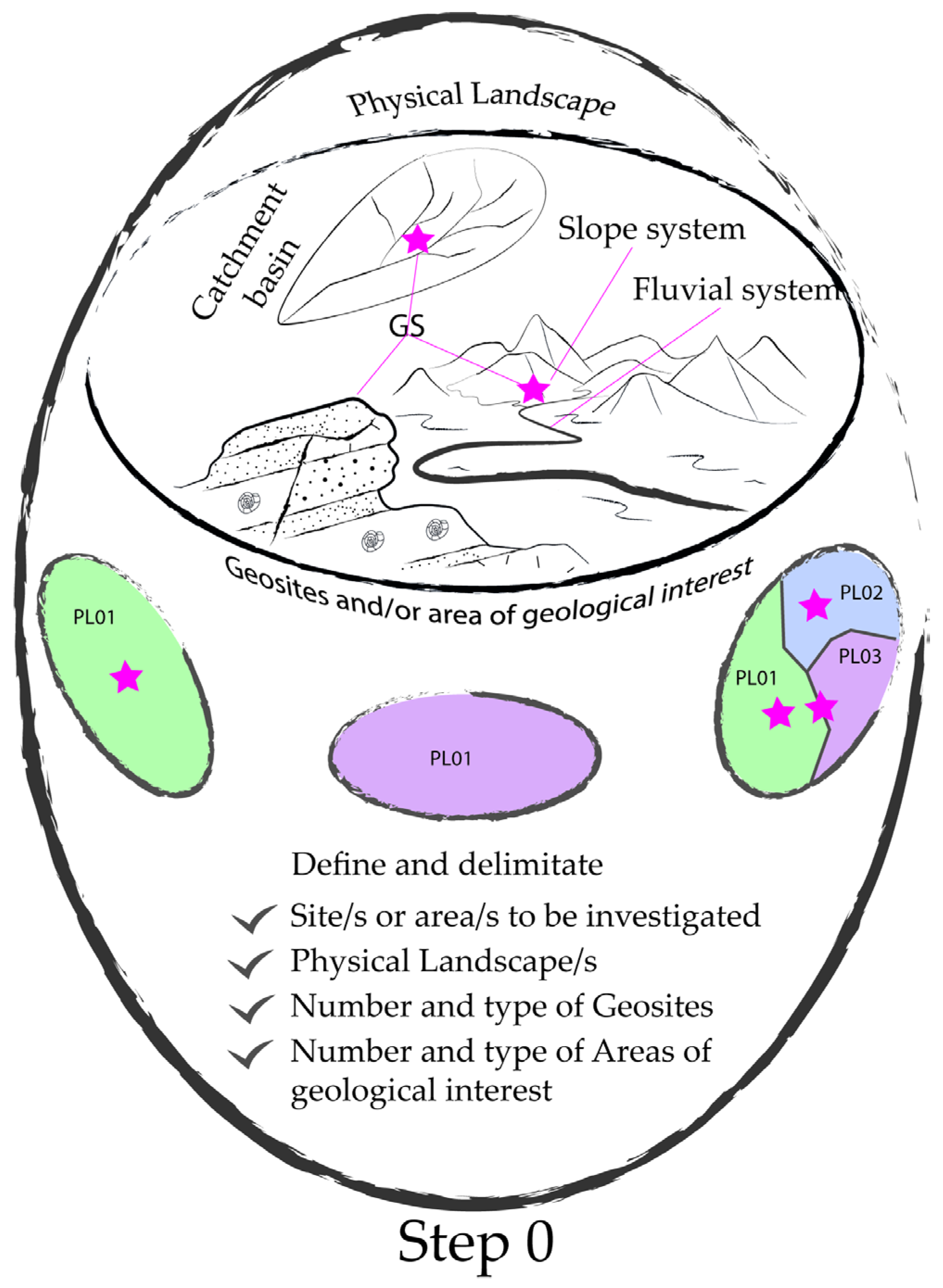
Figure 3. Step 0—Definition of the area that will be studied: define the type, or types, of PL present; define the number and type of present geosites; and define the number and types of areas of present geological interest. Red stars represent GS.
2. Basic Geoconservation
Basic Geoconservation is the basic knowledge, characterization, and study of GSs and PLs, as well as of the territorial, natural, and sociocultural contexts in which they are located, highlighting geo-contexts [9][10][11][12][13] and non-geo-contexts [14][15][16]. The study scale may vary from a micro- to a mega-scale, depending on the type of study, the object of the study, and the purpose of the study. Actions in this context are related to a PL’s definition and characterization, including the components that define it and have an impact on its evolution in terms of their current state, their possible evolution over time, and their criticality as well as vulnerability. In the context of a PL’s abiotic geo-components, GSs must be analyzed and characterized (i) as single entities, at an adequate scale of analysis in terms of the nature and types of GSs; (ii) according to the physiographic unit, represented by the hydrographic basin (one or more) in which they are included, as defined by Fryirs and Brierley (2013) [16]; and (iii) according to the PL in which they are included. Thus, different scales of analysis and characterization are provided: a detailed scale (in situ scale), a hydrographic basin scale, and an overall scale (as an element within the PL). The main purposes of keeping pace with technological and knowledge advances are to (i) ensure the updating of scientific knowledge; (ii) prevent the outdating of scientific knowledge; (iii) promote scientific knowledge exchange; and (iv) monitor scientific knowledge advancement. The main goal is represented by the authoring of scientific papers, the best way to achieve the aforementioned purposes (Table 2).
Table 2. Step 1. Basic geoconservation: main actions and purposes.
| Basic Geoconservation |
|
Physical Landscape |
Component | Abiotic | Geo | Geo-contexts | As a physical landscape’s main components | |
| Geosites and/or sites of geological interest | As essential parts of the physical landscape in which they are included | |||||||
| Non-geo | Anthropogenic structures | |||||||
| Biotic | Bio | Flora | ||||||
| Fauna | ||||||||
| Anthropic | ||||||||
| Critical Issues | Component changes |
Abiotic | Geo | i.e., climate change, seismic risk, volcanic risk, etc. | ||||
| Non-geo | As parts of the physical landscape | |||||||
| Biotic | As geomorphic agents | |||||||
| External pressure |
Anthropic | |||||||
| Main Purposes | ||||||||
| Ensure | Prevent | Increase | Monitor | |||||
| Scientific knowledge | ||||||||
| Updating | Ageing | Exchange | Advancement | |||||
| according to knowledge and technological advancement progresses | ||||||||
This is Step 1 in the approach to geoconservation actions; it has a strong role in subsequent actions to evaluate and classify GSs and PLs as well as identify the most appropriate strategies to protect, improve, and monitor geoheritage (Figure 4).
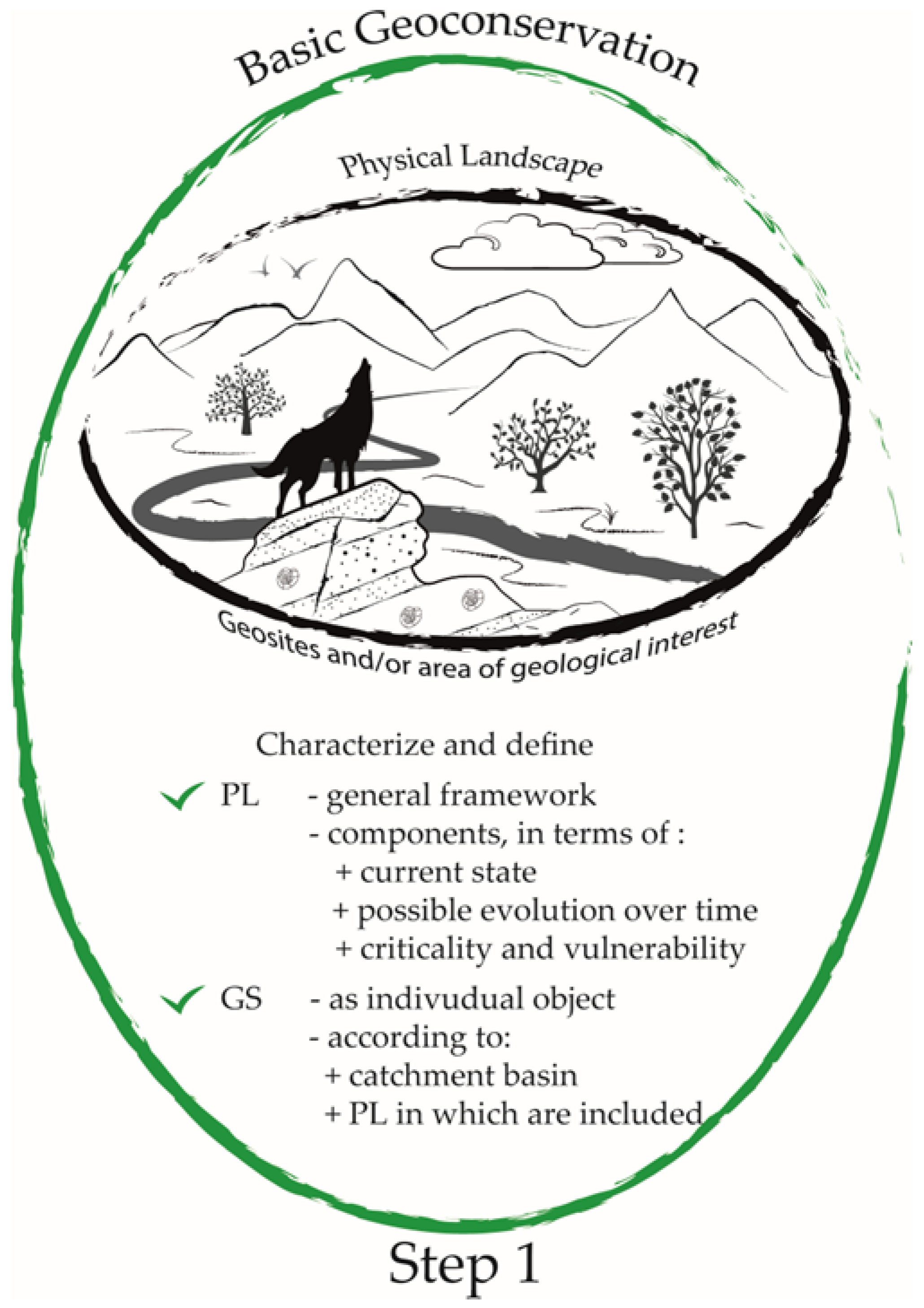
Figure 4. Step 1: Basic geoconservation main action. Silhouette of trees designed by Freepik.
References
- Brilha, J. Inventory and Quantitative Assessment of Geosites and Geodiversity Sites: A Review. Geoheritage 2016, 8, 119–134.
- Council of Europe. European Landscape Convention. Treaty n. 106. 2000. Available online: https://www.coe.int/en/web/landscape/ (accessed on 15 January 2022).
- Amadei, M.; Bagnaia, R.; Di Bucci, D.; Laureti, L.; Lugeri, F.R.; Nisio, S.; Salvucci, R. Carta della Natura alla scala 1:250.000: Carta dei Tipi e delle Unità Fisiografiche di Paesaggio d’Italia. ISPRA. 2000. Available online: https://www.isprambiente.gov.it/it/servizi/sistema-carta-della-natura/cartografia/carta-della-natura-a-scala-nazionale/la-carta-dei-tipi-e-delle-unita-fisiografiche-di-paesaggio-d2019italia (accessed on 10 November 2022).
- Brilha, J.; Gray, M.; Pereira, D.I.; Pereira, P. Geodiversity: An integrative review as a contribution to the sustainable management of the whole of nature. Environ. Sci. Pol. 2018, 86, 19–28.
- Brocx, M.; Semeniuk, V. Geoheritage and geoconservation: History, definition, scope and scale. J. R. Soc. West. Aust. 2007, 90, 53–87.
- Summerfield, M.A. Global Geomorphology; Longman Scientific & Technical, Longman Group Ltd.: London, UK, 1991; p. 537.
- Sharples, C. A Methodology for the Identification of Significant Landforms and Geological Sites for Geoconservation Purposes. Report to The Forestry Commission, Tasmania. 1993. Available online: https://www.researchgate.net/profile/Chris-Sharples-2/publication/266617978_A_Methodology_for_the_Identification_of_Significant_Landforms_and_Geological_Sites_for_Geoconservation_Purposes/links/5435db450cf2dc341db2d2a3/A-Methodology-for-the-Identification-of-Significant-Landforms-and-Geological-Sites-for-Geoconservation-Purposes.pdf (accessed on 30 May 2020).
- Henriques, H.; Peña Dos Reis, R.; Brilha, J.; Mota, T. Geoconservation as an Emerging Geoscience. Geoheritage 2011, 3, 117–128.
- Peña dos Reis, R.; Henriques, M.H. Approaching an integrated qualification and evaluation system of the geological heritage. Geoheritage 2009, 1, 1–10.
- ProGEO. A first attempt at a GEOSITES framework for Europe. An IUGS iniziative to support recognition of world heritage and European geodiversity. Geol. Balc. 1999, 28, 5–32.
- Bruschi, V.M.; Cendrero, A.; Albertos, J.A.C. A Statistical Approach to the Validation and Optimisation of Geoheritage Assessment Procedures. Geoheritage 2011, 3, 131–149.
- Fassoulas, C.; Mouriki, D.; Dimitriou-Nikolakis, P.; Iliopoulos, G. Quantitative assessment of geotopes as an effective tool for geoheritage management. Geoheritage 2012, 4, 177–193.
- Pescatore, E.; Bentivenga, M.; Giano, S.I.; Siervo, V. Geomorphosites: Versatile Tools in Geoheritage Cultural Dissemination. Geoheritage 2019, 11, 1583–1601.
- Giano, S.I.; Pescatore, E.; Biscione, M.; Masini, N.; Bentivenga, M. Geo- and Archaeo-heritage in the Mount Vulture Area: List, Data Management, Communication, and Dissemination. A Preliminary note. Geoheritage 2022, 14, 1–10.
- Pescatore, E.; Bentivenga, M.; Giano, S.I. Geoheritage Management in Areas with Multicultural Interest Contexts. Sustainability 2022, 14, 15911.
- Fryirs, K.A.; Brierley, G.J. Geomorphic Analysis of River System. An Approach to Reading the Landscape, 1st ed.; Wiley-Blackwell: West Sussex, UK, 2013; pp. 1–345.
More
Information
Subjects:
Geography, Physical
Contributors
MDPI registered users' name will be linked to their SciProfiles pages. To register with us, please refer to https://encyclopedia.pub/register
:
View Times:
857
Revisions:
2 times
(View History)
Update Date:
17 Nov 2023
Table of Contents


Notice
You are not a member of the advisory board for this topic. If you want to update advisory board member profile, please contact office@encyclopedia.pub.
OK
Confirm
Only members of the Encyclopedia advisory board for this topic are allowed to note entries. Would you like to become an advisory board member of the Encyclopedia?
Yes
No
${ textCharacter }/${ maxCharacter }
Submit
Cancel
Back
Comments
${ item }
|
${ item.createdUser.fullName }
${ item.createdAt }
${ item.vote }
${ item.reply }
Delete
${ reply.createdUser.fullName }
${ reply.createdAt }
${ reply.vote }
Delete
There is no reply to this comment~
${ item.replyTextCharacter }/${ item.replyMaxCharacter }
Submit
Cancel
More
No more~
There is no comment~
${ textCharacter }/${ maxCharacter }
Submit
Cancel
${ selectedItem.replyTextCharacter }/${ selectedItem.replyMaxCharacter }
Submit
Cancel
Confirm
Are you sure to Delete?
Yes
No