Your browser does not fully support modern features. Please upgrade for a smoother experience.
Submitted Successfully!
 +1 credit
Thank you for your contribution! You can also upload a video entry or images related to this topic.
For video creation, please contact our Academic Video Service.
| Version | Summary | Created by | Modification | Content Size | Created at | Operation |
|---|---|---|---|---|---|---|
| 1 | Xiaomeng Zhang | -- | 3000 | 2023-10-26 15:19:00 | | | |
| 2 | Catherine Yang | Meta information modification | 3000 | 2023-10-27 02:58:31 | | |
Video Upload Options
We provide professional Academic Video Service to translate complex research into visually appealing presentations. Would you like to try it?
Cite
If you have any further questions, please contact Encyclopedia Editorial Office.
Zhang, X.; Wang, W.; Yu, W.; Shen, D.; Zhang, T. River Chief Information-Sharing System Practice in China. Encyclopedia. Available online: https://encyclopedia.pub/entry/50840 (accessed on 26 July 2026).
Zhang X, Wang W, Yu W, Shen D, Zhang T. River Chief Information-Sharing System Practice in China. Encyclopedia. Available at: https://encyclopedia.pub/entry/50840. Accessed July 26, 2026.
Zhang, Xiaomeng, Wei Wang, Wenmeng Yu, Dajun Shen, Tingting Zhang. "River Chief Information-Sharing System Practice in China" Encyclopedia, https://encyclopedia.pub/entry/50840 (accessed July 26, 2026).
Zhang, X., Wang, W., Yu, W., Shen, D., & Zhang, T. (2023, October 26). River Chief Information-Sharing System Practice in China. In Encyclopedia. https://encyclopedia.pub/entry/50840
Zhang, Xiaomeng, et al. "River Chief Information-Sharing System Practice in China." Encyclopedia. Web. 26 October, 2023.
Copy Citation
Controling river water pollution is one of the complex ecoenvironmental challenges facing China’s development today. The river chief information-sharing system (RCISS) in China is an institutional innovation carried out by the government to promote collaborative water governance in the era of big data. In China, the RCISS is primarily practiced at the provincial level. A three-dimensional and intelligent information-management system would be established according to the work plan of the RCS.
river chief system
information sharing
data governance
1. The Content of the Shared Information
Under the current organization system of the RCS, the contents of shared information are primarily concluded in the following categories.
- 1.
-
Basic information.
Basic information could be divided as follows: First, remote-sensing image maps of administrative boundaries, traffic and water systems at all levels. Second, the river chief publicity sign that reflects the river chief’s responsibilities, river and lake overview, management and protection goals, supervision channels and other information. Third, the information about the river chief, including the classification and corresponding responsibilities. Fourth, management information on water conservancy projects, including information about hydrology and water conservancy facilities. Fifth, the river reach management information, including the name and corresponding code of the river reach, hydrological information, the administrative area that the river flows through, the river management level, etc.
- 2.
-
Professional information.
Professional information refers to the information related to river management, which includes the following: First, the shoreline management information of rivers or lakes, such as the delineation of the shoreline space and the functional zones, the development and protection of the shoreline, etc. Second, water resources management information, such as inflow into the rivers or lakes, water supply and consumption status, etc. Third, information on water environment management, such as the discharge of major pollutants, the protection status of the drinking water source, etc. Fourth, water ecological restoration management information, such as information on soil erosion and water conservation.
- 3.
-
Management information.
Management information refers to the information related to river management activities. Specifically, it can be concluded as follows: First, information on the supervision and enforcement, such as the enforcement and supervision of the relevant laws, punishment and rectification of illegal acts, etc. Second, performance appraisal information, such as the river chief patrol records. Third, river problems reported by river chiefs, the public and enterprises, and the solutions to these problems. Fourth, policy information including the latest policies on river management. Fifth, experiences including the successful and failed cases of river management.
2. Information Transmission and Sharing Paths
In order to clarify the transmission and sharing paths of RCS-related information, for this part, the researchers conducted further path analyses in terms of basic information, management information and professional information.
- 1.
-
Basic information.
Basic information is primarily the business data of the public sector, which are currently provided by the government. The government departments, including the water resources department, the ecological and environment department, the natural resources department, the agriculture and rural department, etc., share their information and form a database with their shared information. With the database, integrated information is furtherly transferred and shared by these departments with other participants in the RCS, such as river chiefs, the public and enterprises. Therefore, the analysis of basic information transmission and sharing paths would be carried out firstly within the government subsystem (excluding the river chief) and then among different subsystems. The specific path is as follows:
In the government subsystem of the RCS, the basic information is transmitted and shared in the horizontal and vertical dimensions (see Figure 1). Horizontally, basic information is primarily transmitted within and between administrative areas. In the administrative area, government departments such as the ecological environment department, the natural resources department and the agriculture and rural department transfer the basic information related to river governance to the water resources department. After obtaining the information, these departments form a basic information database and offer information according to the needs of different departments in the administrative area. Among the administrative areas, basic information is transferred from one database to another database. Vertically, the basic information transmission and sharing among governments at the four levels of provinces, cities, counties and towns can be realized through mutual access between different levels’ basic databases.
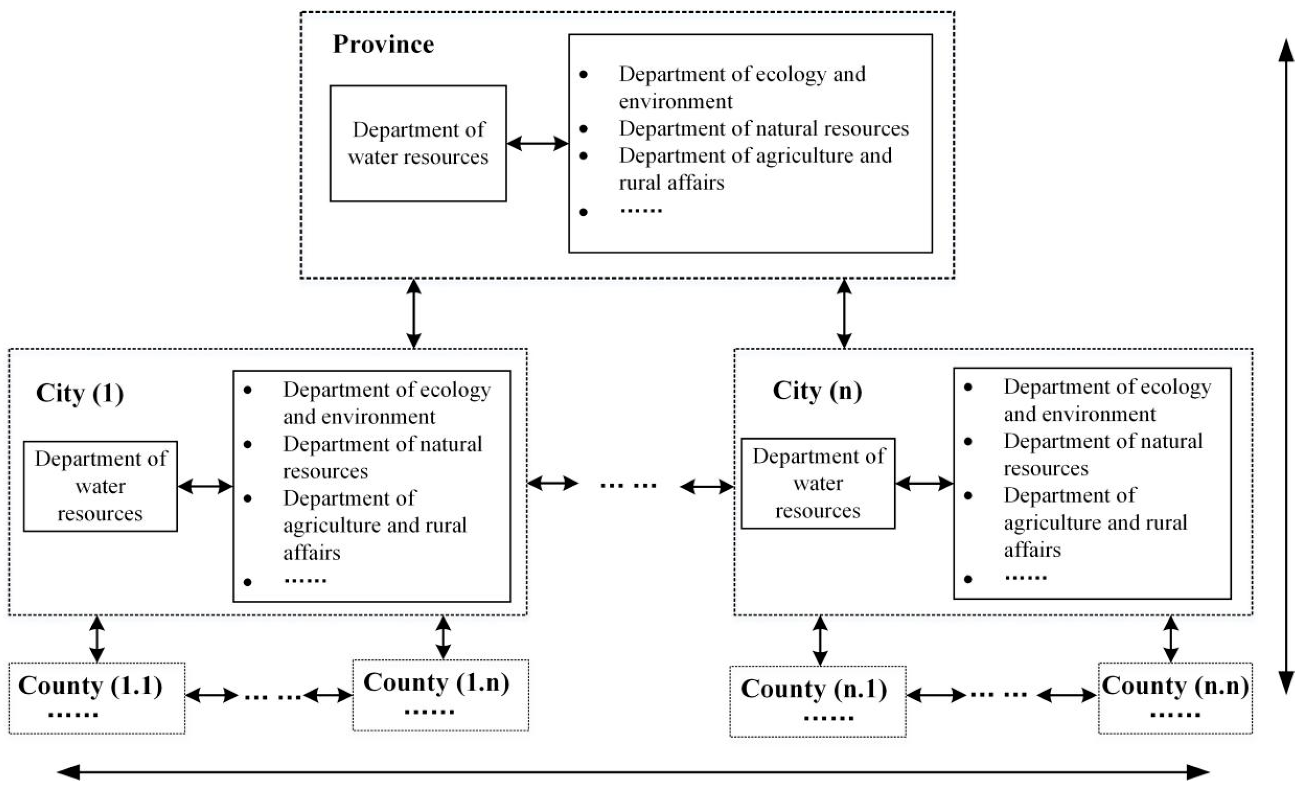
Figure 1. Basic information transmission and sharing in the government subsystem.
On the basis of linking basic information databases in all levels of the government subsystem, a basic information pool is formed to connect with other subsystems. Basic information is primarily transmitted and shared between different subsystems through the following two paths (Figure 2): The first path is that the government departments grant the public and enterprises access to the basic information pool and allow them to directly obtain the information. The second path is that river chiefs at all levels can access the database and provide information to users of the other two subsystems in accordance with the needs of the river governance.
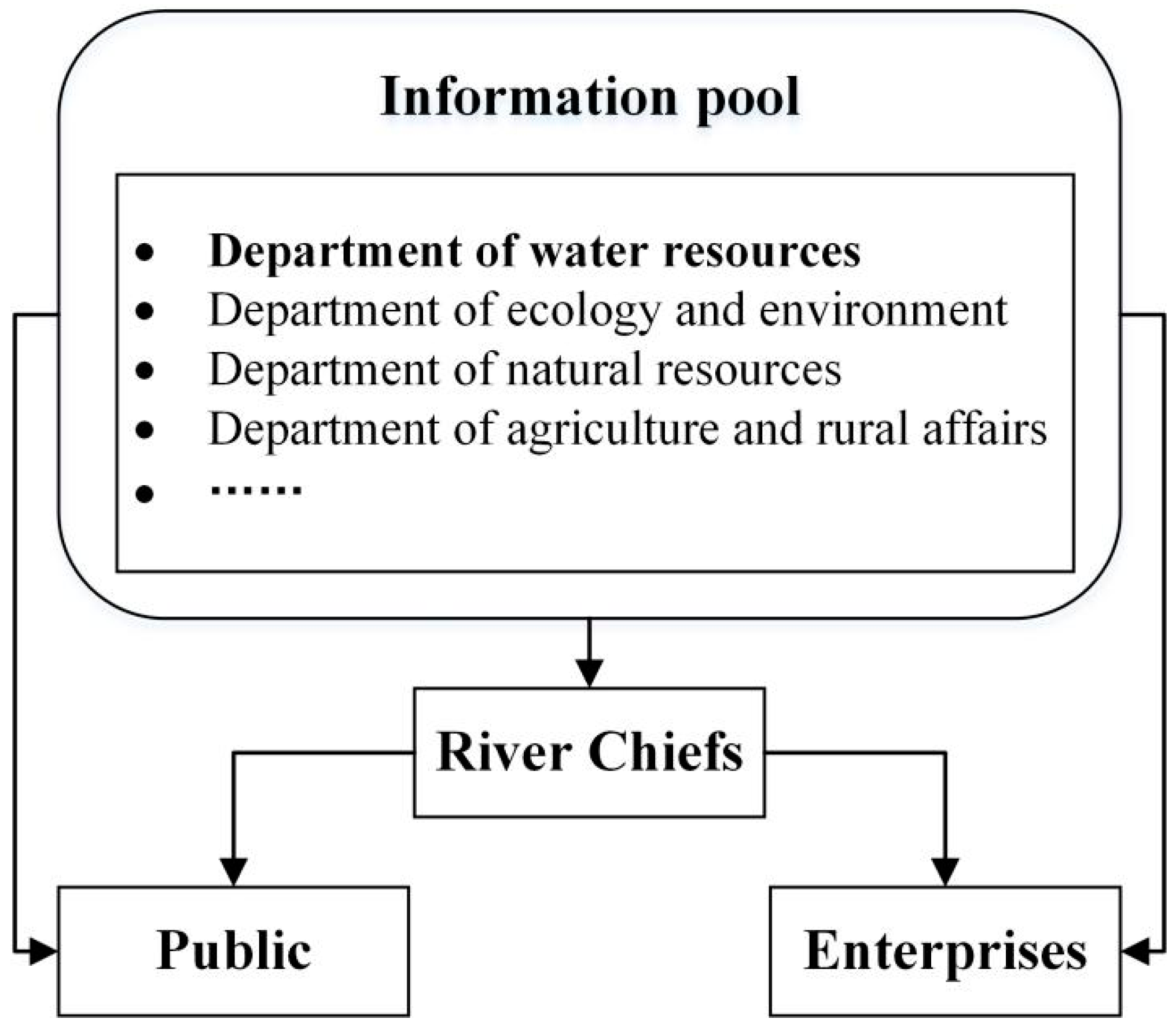
Figure 2. Basic information transmission and sharing among subsystems.
- 2.
-
Professional information.
Professional information includes information related to river basin management and protection. Currently, most professional information is offered by public sectors, including the water conservancy departments and environment departments, while a small amount of information is provided by enterprises in the form of the government’s purchase services. Therefore, the first step is to analyze the professional information transmission and sharing in the government subsystem (excluding the river chief), followed by the analysis of information transmission and sharing among different subsystems. The specific path is as follows:
Similar to basic information transmission and sharing paths, the transmission and sharing paths of professional information also have two dimensions: the horizontal and vertical dimensions (Figure 3). From a horizontal perspective, professional information is transmitted and shared within and among administrative areas. In the administrative area, water resources departments primarily provide river shoreline management information, water resources management information and a small amount of water environment management information and ecological restoration management information. The ecology and environment departments provide supplementary information on water environment management and water ecological restoration management, such as the amount of pollutants entering the river, information on the sewage outlets, the status of the ecological space, etc. All the professional information is used to construct the regional professional information database. Among the administrative areas, professional data can be transmitted and shared so that there is mutual access to different regional professional information databases.
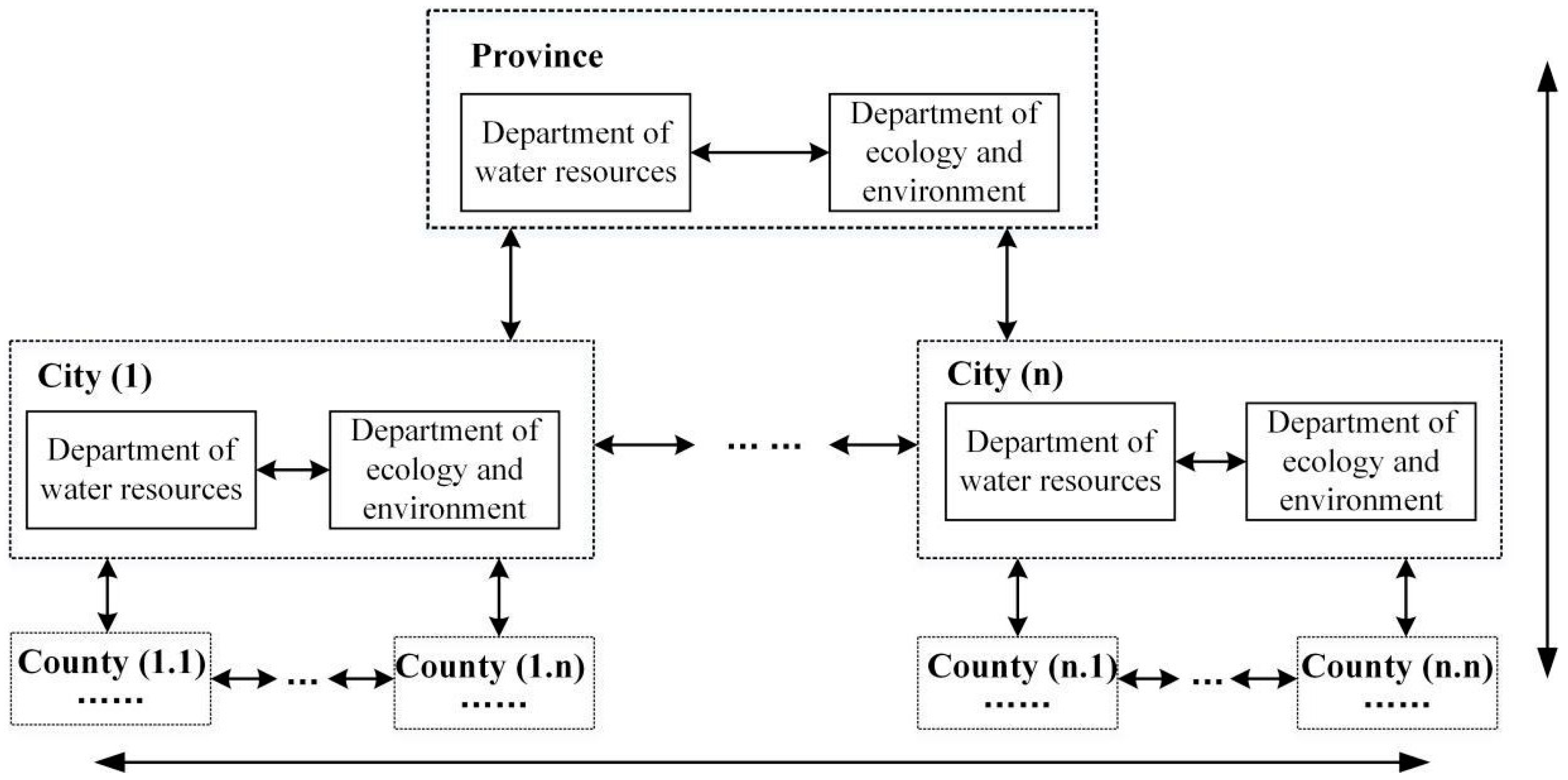
Figure 3. Professional information transmission and sharing in the government subsystem.
From a vertical perspective, professional information transmission is realized through the linkage between the upper and lower professional information databases. From bottom to top, there are two types of information transmission paths: the superiors directly access the information database of the subordinates, or the superior requires subordinates to report professional information through the information transmission channel according to their needs. From top to bottom, the professional information is also transmitted through two paths: the superior directly transmits the information to the subordinate, or the subordinate applies for access to the superior database according to their demands. With the horizontal and vertical multitransmission paths, professional information can be transmitted and shared among four levels of government: province–city–county–township. On the basis of linking professional information databases in all levels of the government subsystems, a professional information pool is formed and connected with other subsystems (Figure 4). The information among subsystems is transmitted through three paths. The first path is “information pool-river chief-the public”. River chiefs obtain professional information by visiting the information pool and then directly provide the public with information according to their management needs. The information pool can be opened directly to the public and provides the information that they required (the public here includes the general public and the nongovernmental river chiefs). The second path is “information pool-river chief-the enterprise”. River chiefs can access professional information from the database and pass the information to the enterprises according to management requirements. Or, the enterprises can obtain the information due to the open access of the database. At the same time, these enterprises supporting the river governance in turn transmit their professional information to the information pool. The third path is “river chief-the public-the enterprise”. River chiefs transmit professional information to the public and enterprises because they perform their duties. As for the enterprises, the river-resource-consuming enterprises disclose professional information such as water withdrawals and pollution discharge, while the river-governance-serving enterprises provide support to the river chiefs and the public by opening their professional information.
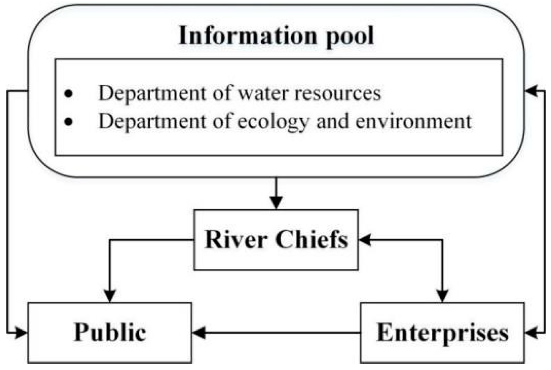
Figure 4. Professional information transmission and sharing among subsystems.
- 3.
-
Management information.
Management information is the information generated by all participants in river governance. Here, the major subjects primarily include river chiefs, river chief system administrative departments, the public and enterprises. The specific paths for management information transmission and sharing are shown in Figure 5. In the government subsystem, the management information is transmitted with river chiefs as the core. At the same level, government departments (such as water conservancy departments and environmental departments, etc.) pass their management information to river chiefs, while river chiefs in turn provide obtained information to the relevant departments. Between the different levels, routine management information (such as information on supervision and law enforcement, river patrol records, etc.) is reported by the river chief department to its higher-level river chief department or delivered to the lower-level one. Similarly, special management information (such as the river chief tasks, the latest policies, the needs of the river chiefs, etc.) is also transmitted between the upper and lower levels by the river chiefs.
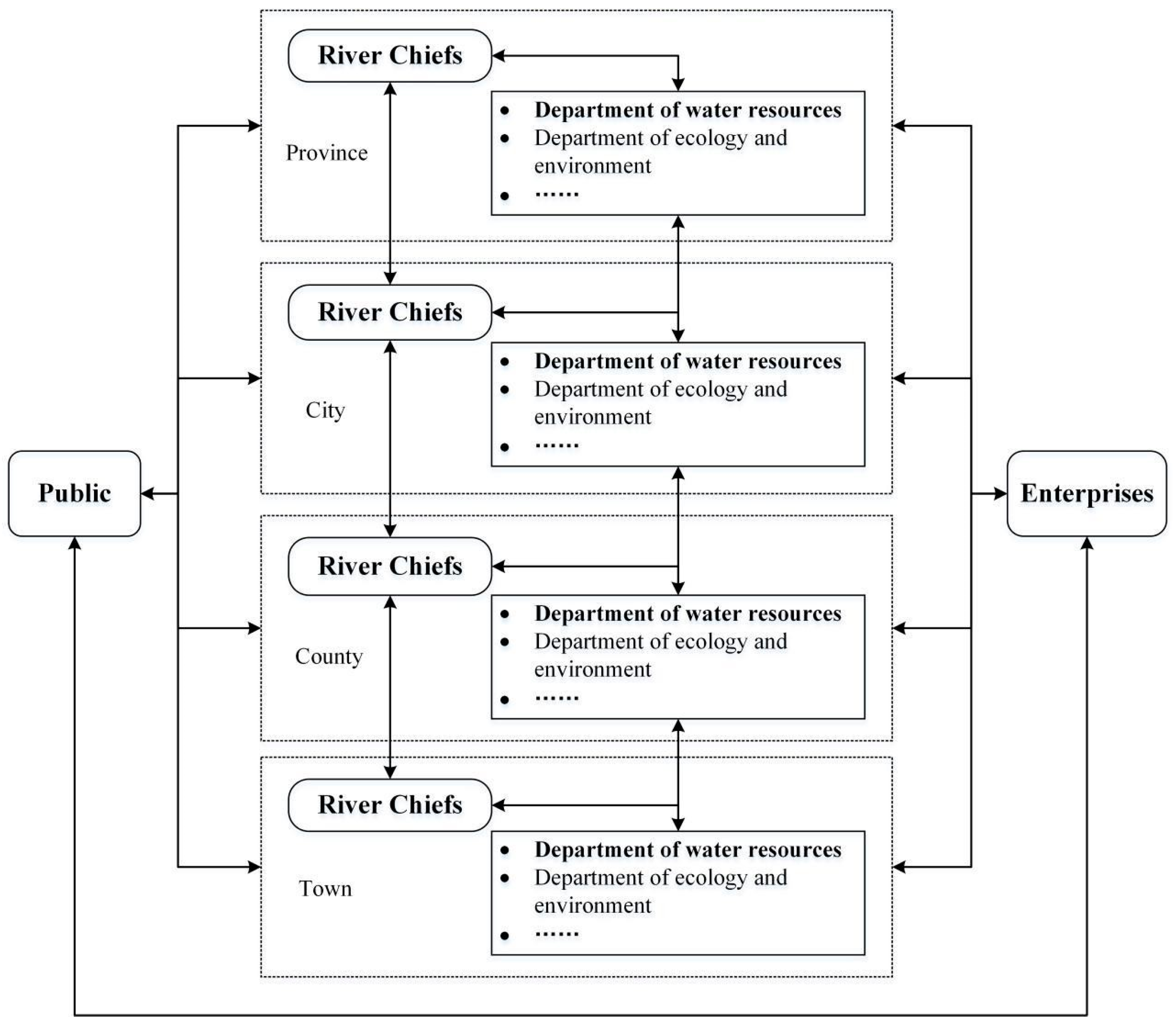
Figure 5. Transmission and sharing paths of river chief management information.
In the public subsystem, as for the general public, if they find problems in the river governance (such as excessive river discharge, illegal water withdrawal, etc.) or negligence of the river chiefs and governmental departments, they can report these problems to the river chiefs and river chief system authorities at all levels. Meanwhile, river chiefs and river chief system authorities at all levels should deal with these problems and give timely feedback. Another type of public subsystem is nongovernmental river chiefs selected by the general public; they report the performance of their duties to their superiors and receive information about their tasks.
In the enterprise subsystem, river-resource-consuming enterprises disclose information regarding the utilization of river resources (such as water withdraws, sewage discharge into the river, river sand mining, etc.) to river chiefs and river chief administrative departments at all levels and the public, whereas the enterprises obtain dynamic information (such as changes in water resources, river navigation situation, etc.) from water conservancy departments and environmental departments. River-governance-serving enterprises deliver service information related to river governance to river chiefs and river chief departments at all levels and to the public. At the same time, these enterprises obtain information that supports decision-making processes from river chiefs and river chief system authorities at all levels and the public.
3. Structure and Operation of RCISS Intelligent Platform
The intelligent platform is an important place for the operation of the RCISS. Currently, the RCISS intelligent platform generally consists of five layers, which are the information-acquisition layer, information-resources layer, information-sharing layer, information-application layer and information-user layer [1], as shown in Figure 6.
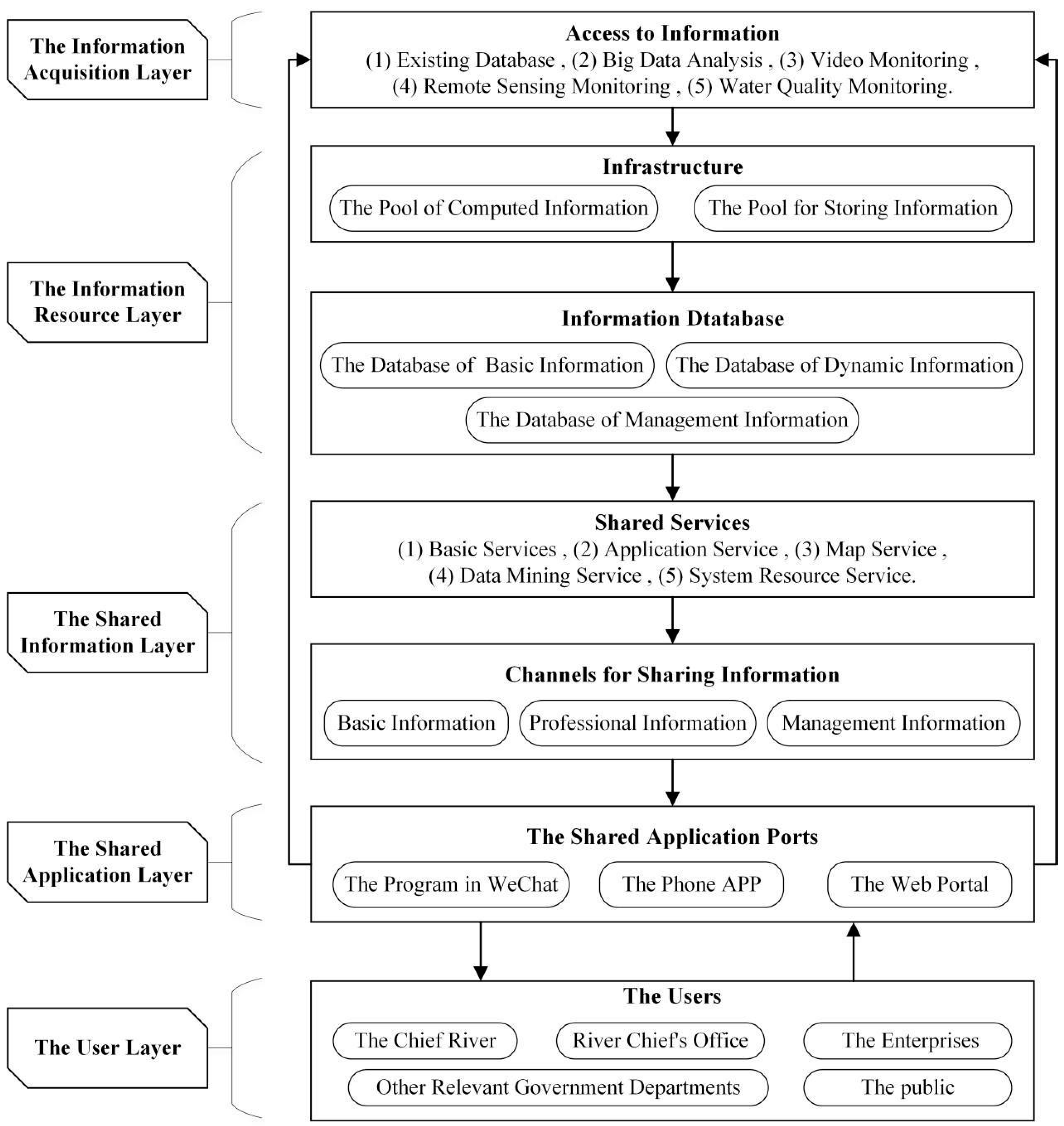
Figure 6. The intelligent platform of RCISS [1].
-
The information-acquisition layer links to the existing river and lake information database and is used to conduct the cleaning and preliminary analysis of the obtained data.
-
With the information-resource layer, the standardized calculation and storage procedures of the input information are executed, and the information is accurately classified to form a shared information database that includes a basic information database, a dynamic information database and a management information database.
-
The shared information layer provides information-sharing services that include basic information sharing, data-mining services, etc. It also forms a shared information channel that includes a basic information channel, a professional information channel and a management information channel.
-
The shared application layer is an interactive window for information sharing with three application ports: the WeChat application, mobile phone apps and Web portal.
-
The user layer is primarily open for all the users involved in the RCS, including river chiefs at all levels, river chief offices at all levels, river chief cooperative units, related enterprises and the public.
The five layers composing the RCISS form an information-sharing closed loop of “acquisition-processing-sharing-feedback” (Figure 6). The specific operation mechanism can be decomposed as follows: Firstly, with the information-acquisition layer, data are acquired by accessing the interface of the relevant government department information database, using big data technology to mine the Internet information or directly adopting real-time monitoring technology. Then, the obtained information is transmitted to the information-resource layer and is used to form the information resources reserve through the procedures of identification, classification, processing and standardization. Secondly, by linking the information-resource layer to the shared information layer, the processed information would be transmitted to the shared information layer and provided to users according to their needs. The third step is to form the information-sharing channel and the information-feedback channel. Three channels of basic information, professional information and management information are established through the linkage between the shared information layer and the shared application layer, while the user information feedback channel is formed by connecting the application layer and the information-acquisition layer (e.g., the application includes the independent applications such as a dedicated application or website, as well as an application embedded in other applications such as the WeChat application). Finally, users can access the information through the application window and share their information through the feedback channel. Through the information-sharing system, the government, the public and enterprises can realize the circular flow of information via “sharing-feedback-sharing”. Information sharing has been realized among the government, the public and enterprises.
4. Typical Achievements
4.1. RCISS in Beijing
The RCISS in Beijing is a typical case of realizing the data interaction of the multiple-services platforms of the river chief system. It succeeds in providing information resources to implement the RCS via information exchange among the platform of big data analysis and display, the platform of information collecting, the river chief system information platform of the Ministry of Water Resources and the district-level river chief system platform. The functions of river management include:
-
Water resource conservation. The information-sharing system provides government departments, water consumption enterprises and the public with real-time information on water resource protection. It realizes the maintenance, publication, browsing and inquiry of water resource protection information and interaction among multiusers.
-
Shoreline management of the river. The system makes it possible to share information on the whole management process of the demarcation of shoreline waters and real-time information on mobile inspection and automatic monitoring.
-
Water pollution prevention and control. The pollution monitoring system locks the number and location of pollution sources and transmits it to the information processing center to generate evaluation information, which is then shared with various management departments.
-
Water environmental management and ecological restoration. The information-sharing system can conduct differentiated data processing and analysis on water environment monitoring information, water environment simulation and analysis information, water environment remote-sensing evaluation information and water quality warning information and share the results with relevant departments.
-
Strengthening law enforcement and supervision. The information such as team information on water administration supervision, water dispute warning information, water administrative permit project real-time monitoring information, water administrative penalty real-time monitoring information, etc. is shared in this system to strengthen the enforcement and supervision.
According to the statistics, there are approximately 12,000 end users of the Beijing river chief information-sharing system, and about 2500 users were online every day until 2020. These users include third-party inspectors and river chiefs in cities, districts, towns (streets) and villages. As of February 2020, based on the terminal application of the Beijing river chief information-sharing system, 350,000 river patrols have been carried out. The total length of the patrols exceeded 1.2 million km, and more than 2000 problems were reported [2].
4.2. The Transregional Joint River Chief Information-Sharing System in the Yangtze River Delta
Currently, the transregional joint river chief information-sharing system in the Yangtze River Delta is in its pilot stage. The regions covered by the joint information system include Qingpu District in Shanghai; Wujiang District in Suzhou City, Jiangsu Province; and Jiashan county in Jiaxing, Zhejiang Province. There are about 46 transboundary rivers in the 2300 km2 area covered by the system. The information-sharing service is primarily for the joint river chiefs at all levels of the three prefectures, the office of the river chief system at all levels, and the relevant member units of the river chief system, such as the departments of water conservancy, water affairs, agriculture and rural areas, ecological environment, transportation and other departments [3]. With the help of the joint river chief information-sharing system, transboundary water quality monitoring sections have shown a significant improvement trend [4].
The major function of the information-sharing system is to share river governance information, including information on the progress of bordering river governance; interpretations of the latest water ecological environment policy; typical cases; and experiences in terms of river management ideas, technologies and approaches. Specifically, the system function can be subdivided into the following five aspects:
-
The river information database is used to collect and process basic information about rivers, which supports various governance entities to formulate working plans.
-
The river chief performance platform is used to record and share the performance of river chiefs at all levels, feedback problems and corresponding handling methods and the progress of governance work.
-
The problem-handling platform is responsible for coping with the problems discovered by river chiefs at all levels or those reported by the public. For example, the public can upload photos, videos, problem locations, problem types and other related information about water issues to the platform through WeChat and then leave a contact number for follow-up feedback.
-
The river-water-quality information-sharing platform can be used for water quality data statistics and a water quality analogy judgment. Once verified by the water quality inspection unit, the water quality data of the border river can be regularly publicized on this platform. The river chiefs at all levels can check the water quality of the river they are responsible for on the river chief app.
-
The online information-exchange platform can be used for internal quick contacts and document transfers.
References
- Ju, M.S. River Chief System Policy and Organization; China WaterPower Press: Beijing, China, 2019.
- Tang, M.; Yin, X.N.; Li, X. Application Design and Development of Smart Mobile Terminal of River Chief in Beijing. Yellow River 2020, 42, 164–168. (In Chinese)
- Shen, J.W.; Jin, X.; Wang, Z. Brief introduction of information management system for implementing joint river chiefs in Yangtze River Delta demonstration area. China Water Resour. 2020, 20, 34–35. (In Chinese)
- Shu, Z.; Hu, X.; Wu, Z.; Ji, Y.; Han, F.; Liu, Y.; Lu, X. Exploration and Practice of Long-term Mechanism for Transboundary River and Lake Management in the Yangtze River Delta Demonstration Area. Water Dev. Res. 2021, 21, 48–54. (In Chinese)
More
Information
Subjects:
Water Resources
Contributors
MDPI registered users' name will be linked to their SciProfiles pages. To register with us, please refer to https://encyclopedia.pub/register
:
View Times:
580
Revisions:
2 times
(View History)
Update Date:
27 Oct 2023
Table of Contents


Notice
You are not a member of the advisory board for this topic. If you want to update advisory board member profile, please contact office@encyclopedia.pub.
OK
Confirm
Only members of the Encyclopedia advisory board for this topic are allowed to note entries. Would you like to become an advisory board member of the Encyclopedia?
Yes
No
${ textCharacter }/${ maxCharacter }
Submit
Cancel
Back
Comments
${ item }
|
${ item.createdUser.fullName }
${ item.createdAt }
${ item.vote }
${ item.reply }
Delete
${ reply.createdUser.fullName }
${ reply.createdAt }
${ reply.vote }
Delete
There is no reply to this comment~
${ item.replyTextCharacter }/${ item.replyMaxCharacter }
Submit
Cancel
More
No more~
There is no comment~
${ textCharacter }/${ maxCharacter }
Submit
Cancel
${ selectedItem.replyTextCharacter }/${ selectedItem.replyMaxCharacter }
Submit
Cancel
Confirm
Are you sure to Delete?
Yes
No