Your browser does not fully support modern features. Please upgrade for a smoother experience.
Submitted Successfully!
 +1 credit
Thank you for your contribution! You can also upload a video entry or images related to this topic.
For video creation, please contact our Academic Video Service.
| Version | Summary | Created by | Modification | Content Size | Created at | Operation |
|---|---|---|---|---|---|---|
| 1 | Márton Veress | -- | 4277 | 2023-10-20 08:12:59 | | | |
| 2 | Camila Xu | Meta information modification | 4277 | 2023-10-20 08:39:09 | | |
Video Upload Options
We provide professional Academic Video Service to translate complex research into visually appealing presentations. Would you like to try it?
Cite
If you have any further questions, please contact Encyclopedia Editorial Office.
Veress, M. Landscape Evolution in Glacier Valleys of Glaciokarsts. Encyclopedia. Available online: https://encyclopedia.pub/entry/50595 (accessed on 07 June 2026).
Veress M. Landscape Evolution in Glacier Valleys of Glaciokarsts. Encyclopedia. Available at: https://encyclopedia.pub/entry/50595. Accessed June 07, 2026.
Veress, Márton. "Landscape Evolution in Glacier Valleys of Glaciokarsts" Encyclopedia, https://encyclopedia.pub/entry/50595 (accessed June 07, 2026).
Veress, M. (2023, October 20). Landscape Evolution in Glacier Valleys of Glaciokarsts. In Encyclopedia. https://encyclopedia.pub/entry/50595
Veress, Márton. "Landscape Evolution in Glacier Valleys of Glaciokarsts." Encyclopedia. Web. 20 October, 2023.
Copy Citation
On mountain glaciokarsts, climate and vegetation show zonality. With altitude increase, the quantity of precipitation increases (the proportion of snow increases) and temperature decreases.
glacier valley
epikarst
limestone debris
dissolution
1. Introduction
This study describes the landscape evolution of various parts of karstic glacier valleys considering the glaciokarst areas of the Alps and the Dinarides (e.g., Dachstein, Totes Gebirge, Julian Alps, Biokovo Mountains, Durmitor). Further glaciokarstic glacier valleys can be mentioned from other parts of the Alps and the Dinarides and from the Pyrenees, the Apennines, Rila, the Caucasus, the Aladağ Mountains, the Pindus Mountains, the Altai, the British Islands, the Scandinavian Mountains, the Appalachian Mountains, etc. [1]. The peculiarity and complexity of the topic are due to the fact that in glacier valleys, glacial, karstic, and non-karstic landscape evolution (frost weathering, mass movements) occur simultaneously and influence each other. In the future, climate change will modify the character and intensity of geomorphic evolution taking place in glacier valleys and also the distribution of various landscape evolution varieties.
Glaciokarst is karst subject to glacial erosion [2]. Features of glaciokarst may be of karstic and non-karstic origin. Karstic features may be of karstiglacial origin, glaciokarstic origin, and mixed origin [3]. Karstiglacial features are of glacial origin, but they are transformed in a karstic way. In the case of glaciokarstic features, karstic features were transformed by glacial erosion. Mixed features were affected by several glacial and karstic impacts.
On mountain glaciokarsts, climate and vegetation show zonality. With altitude increase, the quantity of precipitation increases (the proportion of snow increases) and temperature decreases. Thus, with altitude increase, the duration of dissolution increases. However, the dissolution intensity decreases as a consequence of the decrease in biogenic CO2.
In the mentioned areas on mountain glaciokarsts, the altitude difference is large as compared to both the local base level of erosion and the karst water level. However, the thickness of karst rocks is also great. All this results in the fact that karstification in the vadose zone is widespread, significant, and vertically developed.
The karst water level fluctuated in the area of glacier valleys. In the glacials, since the water output sites were blocked (springs were covered by ice), its level increased, while in the interglacials, it decreased [3][4][5]. Consequently, the epikarst might have been affected by phreatic effects. Karren features of the epikarst of glaciokarst and their drainage passages (pits) are well developed. Its section with cavities is less developed partly because the dissolution capacity might have been used up during the development of karren, and partly because glacial erosion destroyed them during the destruction of the bearing rock. Cavities that survived glacial erosion constitute the paleoepikarst, while cavities presently developing form the recent part of the epikarst with karren together (however, some karren features such as Schichtfugenkarren may have been inherited). The drainage of the so-called karren features of flow origin [6] into the karst contributes to the development of the section with cavities and the further development of the paleoepikarst. However, some karren features may also have been formed under glaciers since the concretions of valley floors, which can be detected and are continually developing at present too [7] refer to dissolution below the ice.
In glacier valleys, glacier erosion destroyed the rocks by beds [1]. Consequently, a series of cuestas developed on valley floors and on slopes with bedding planes and scarp fronts situated above each other (Figure 1). Uncovered bedding planes of large extension provide favorable conditions for undisturbed water flow and the development of karren features of flow origin (rinnenkarren, meanderkarren, rillenkarren, wandkarren) [8].
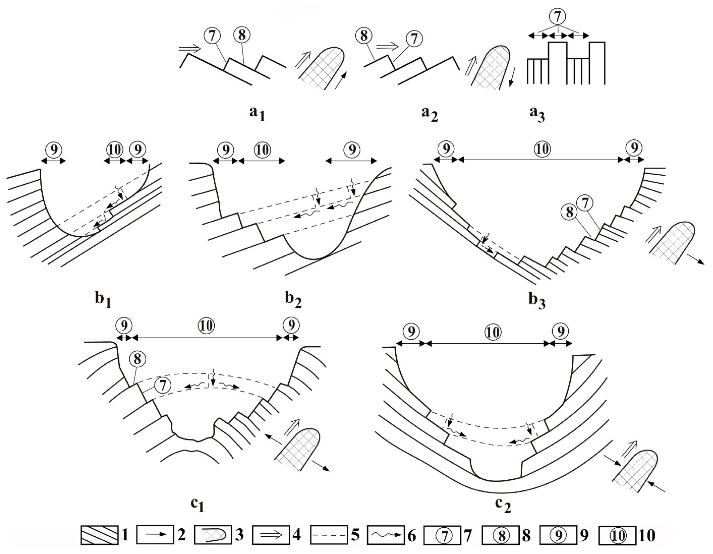
Figure 1. Cuestas and glacier valley cross-sections [9] (modified). 1. Beds, 2. direction of bed dipping, 3. glacier in plan view, 4. direction of glacier movement, 5. former bed unit, former fracture, 6. water percolation, 7. scarp front, 8. exposed bedding plane, 9. steep valley slope with cliffs, 10. gentler valley slope and valley floor with steps; (a). valley developed in dip direction, (a1). direction of ice movement was identical to the dip direction of beds, (a2). direction of ice movement was opposite to the dip direction of beds, (a3). the beds are vertical, (b1). the valley is of strike direction, asymmetric valley cross-section, on one side of the valley the exposed bedding planes dip towards the center of the valley, (b2). the valley is of strike direction, asymmetric valley cross-section, on one side of the valley, the exposed bedding planes dip towards the margin of the valley, (b3). the valley is of strike direction, asymmetric valley cross-section, on one of the valley slopes, the exposed bedding planes dip towards the center of the valley, while on the other valley slope, they dip towards the margin of the valley, (c1). valley developed on an anticline, (c2). valley developed on a syncline.
Glaciokarst terrains are partly bare or covered by soil only. However, moraines of limestone material, materials of frost weathering, and mass movements cover large areas, but dissolution residue (clay) also occurs in small quantities. Waters percolating through limestone debris become partly or completely saturated. Therefore, Williams [10] states if the thickness of the cover of limestone debris exceeds 45.72 cm, no dissolution takes place on the bedrock any more because the infiltrating water becomes saturated in the cover. Depending on the quantity of biogenic CO2 [11][12], dissolution may take place on the bedrock if the thickness of the bedrock is different from this value. Sweeting [2] claims that saturation occurs in the cover thickness is 2 m. With the increase in altitude and slope angle, the degree of coveredness with soil and soil thickness decreases, vegetation becomes sparse, and, therefore, CO2 production decreases. The water infiltrating through the caprock of calcareous material (moraine, frost weathering debris) exerts a dissolution effect. Therefore, in the case of a given CO2 amount with the increase in cover thickness, there is a higher chance of the water becoming saturated in the cover. Thus, the saturated water arriving at the bedrock is not able to exert a dissolution effect. As a result of the latter, saturation takes place in the case of a smaller and smaller cover thickness, before the water arrives at the bedrock. However, due to concentrated water inflows, in areas without soil, saturation does not necessarily take place in the cover either in the case of a cover thickness value larger than that given by Williams [10].
The main karstic and non-karstic features of glaciokarsts are described in Figure 2 and Figure 3. Among karst features, karren, giant drawdown dolines (paleodolines), recent drawdown dolines, collapse dolines, schachtdolines, ponors, shafts, and poljes can be mentioned [3][6][13][14][15][16][17][18][19][20][21][22]. Both the karren of flow origin and karren of percolation origin may occur on bare surfaces, but the karren of percolation origin also develop of soil-covered surfaces [6]. Karren of flow origin mainly occur at altitudes of 1600–2000 (2200) m in the Alps. Giant dolines (preglacial drawdown dolines) may occur anywhere on the floor of throughs. Some cirques are of glaciokarstic origin since they emerged from giant dolines [4][18][23][24][25]. Their diameter may reach several 100 m. Most of them are lined with superficial deposits. Giant dolines are not active features.
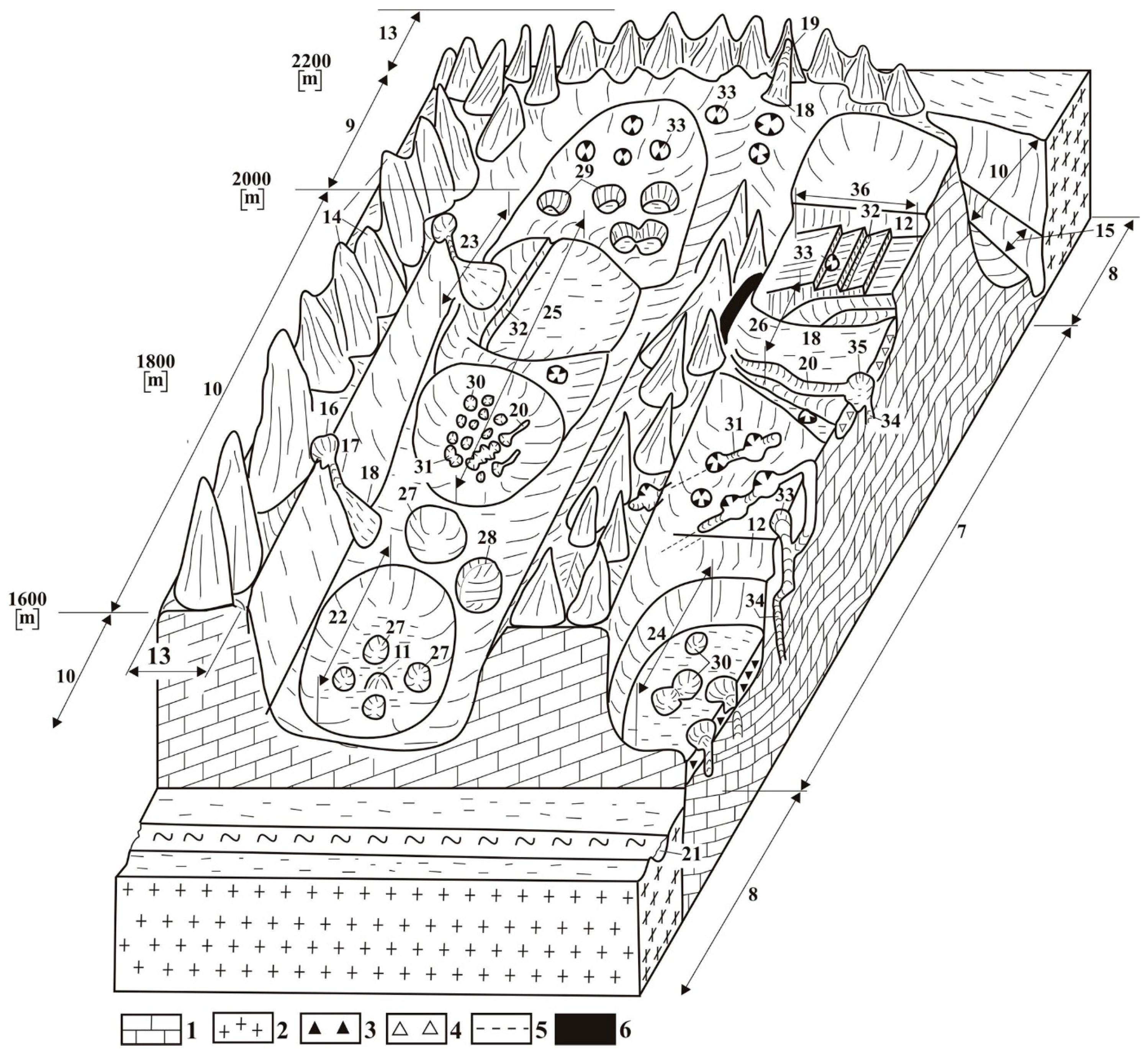
Figure 2. Main features in the glacially transformed karstic high mountains [6 modified]: 1. Limestone, 2. older metamorphic basement, 3. moraine, 4. colluvial debris, 5. fault, 6. siliceous interbedding in limestone, 7. Klippen (plateau), 8. eroded portion of nappe, 9. cirque, 10. trough, 11. roche moutonnée, 12. tarn backwall, 13. arête, 14. horn, 15. river valley, 16. niche with circular rim, 17. niche of frost shattering, 18. talus cone, 19. path of rock avalanche, 20. furrow of covered karst depression, 21. river, 22. paleodoline, 23. asymmetric paleodoline, 24. paleodoline with moraine, 25. paleouvala, 26. partially filled paleodoline, 27. recent solution doline, 28. asymmetric solution doline, 29. schachtdoline, 30. subsidence doline, 31. subsidence uvala, 32. giant chasm (bogaz), 33. shaft system, 34. passage, chimney, shaft system in cross-section, 35. ponor, 36. schichtrippenkarst.
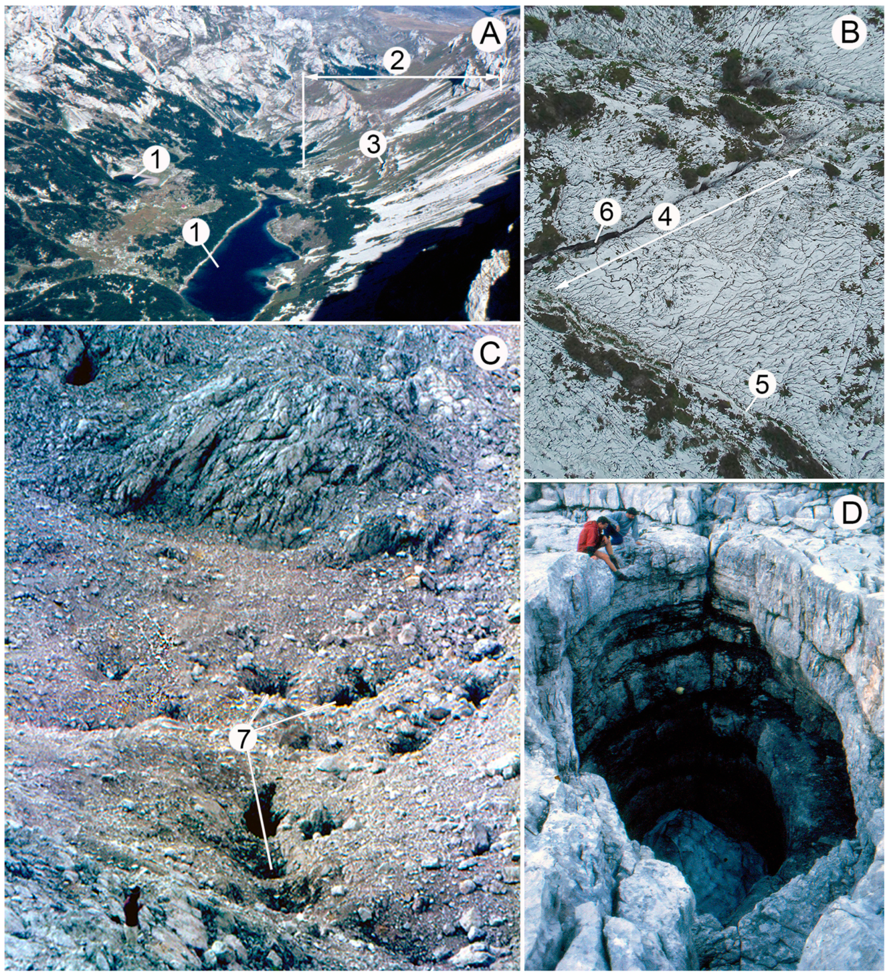
Figure 3. Some features of glaciokarst: (A) Giant drawdown dolina, Skryke (Durmitor, Montenegro, photo by Veress), (B) bedding plane surface with rinnenkarren (Totes Gebirge, Austria, photo by Veress), (C) giant drawdown doline, with subsidence dolines on its floor (Julian-Alps, Slovenia, photo by Veress), (D) shaft (Totes Gebirge, photo by Veress). Legend: 1. Rock basin, 2. debris slope, 3. margin of partial doline covered with debris, 4. surface with bedding planes, 5. cuesta, 6. giant grike, 7. subsidence dolines.
Recent, presently developing dissolution dolines are smaller than the previous ones, which can be regarded as features of postglacial age [26]. Above the tree line, schachtdolines are more and more widespread instead of these features [3][17][27]. The depth of these features exceeds their diameter.
In areas covered with caprock, subsidence dolines (mainly suffosion dolines, but dropout dolines also occur) are widespread both in troughs and cirques. Their morphological environment is diverse. They are also characteristic in paleodolines, on interfluves, but in poljes too [1]. These features are characterized by large density and small size.
The size (mainly of vertical shafts) and density of shafts increase with an altitude increase. They were formed in the glacials and interglacials. They have a significant sediment-receiving capacity if the debris can be transported to them. Among polje types, piedmont poljes are specific, which is a feature, partly controlled by glaciers [2][16][22][28].
The number and size of the caves of glaciokarsts is large. They often develop at ponors and may have significant sediment-receiving capacity [1][29].
2. Geomorphic Evolution Types
At glacier valleys, the landscape evolution of troughs and cirques is distinguished. The trough of the glacier valley may develop into a river valley in a way that the V-shaped valley is transformed into a U-shaped valley [30]. The trough may be formed by the merging of paleokarst depressions by glacial erosion [1]. The landscape evolution of the trough depends on the development way. Thus, if the trough developed from a former river valley, the paleodepressions have a small depth as compared to the valley and are situated on the valley floor, while on valley sides, stepped surfaces are widespread. If the trough developed from paleodepression, they constitute the whole valley. In the former case, there is a dual geomorphic evolution in the valley: one of them takes place in the depressions, the other, on the valley sides. In the latter case, the valley development coincides with the landscape evolution taking place in the area of the depressions.
In the case of river valleys, the valley head is transformed into a cirque which develops into a depression [31][32][33]. However, the cirque may also be formed from a karstic depression [4][17][24][25][34][35]. In the former case, the cirques are closed; in the latter, open cirques also occur among them or they are closed only to a low degree. In the case of cirques with closed depressions, the material that was formed by the denudation of side slopes is accumulated on the floor and transported into the karst through shafts and passages. In the case of cirques of open depressions, some part of the stream load is transported into the trough below the cirque.
Geomorphic evolution is associated with specific material cycles. The material cycle of troughs is described in Figure 4 [1], and that of cirques is demonstrated in Figure 5 [1]. In troughs, the geomorphic evolution of bare surfaces with cuestas and that of surfaces covered with caprock is distinguished. In the latter case, the development in the area of the depressions is described separately.
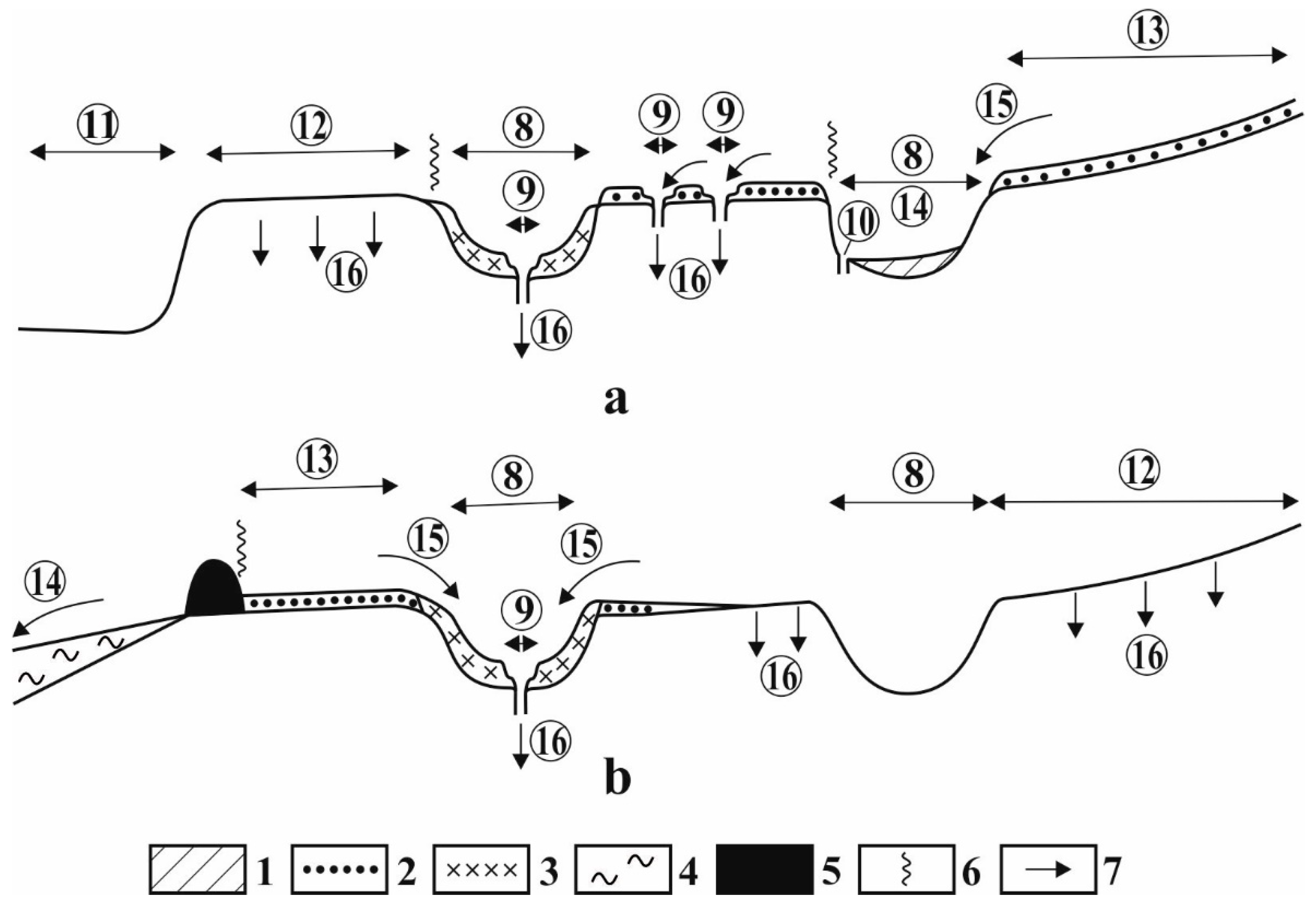
Figure 4. Theoretical turnover of a trough: (a). Hanging trough, (b). trough with terminal moraine (karstic depressions develop in the total width of the floor); 1. impermeable cover, 2. basal moraine (permeable), 3. reworked, permeable cover, 4. fluvioglacial sediment, 5. terminal moraine, 6. barrier of material transport, 7. material transport, 8. giant solution doline, 9. subsidence doline, 10. ponor, 11. main valley, 12. bare karst, 13. concealed karst, 14. allogenic karst, 15. water transport from the cover (suspended, rolled, in solution), 16. material transport into the karst.
Figure 5. Theoretical turnover of a cirque (karstic depressions are not aligned along the profile): 1. Impermeable cover, 2. basal moraine, 3. reworked permeable moraine, 4. debris (material of frost weathering and avalanches), 5. material transport (water transport and in solution) into the karst, 6. retreat of the cirque slope, 7. combe-ridge, 8. cirque floor, 9. debris cone, 10. giant solution doline, 11. shaft, 12. subsidence doline, 13. ponor, 14. material transport from the rock wall by stream (suspended and in solution), 15. material transport by avalanches, 16. debris fall and collapse, 17. water transport from the cover (suspended, rolled, in solution), 18. material transport into the karst.
2.1. Landscape Evolution on Covered trough Section
On surfaces covered with superficial deposits, the cover may become thicker or thinner. Thickening occurs when more sediment arrives at a given place than is transported away. This may take place both in the lack and the presence of transportation away. Transportation away may be superficial, erosional, and karstic. Superficial erosional material transport is specific. The sediment is rarely transported out of glacier valleys because both the trough (and some of its parts) and the cirque are areic. Fluvial material transport (and thus, denudation is local) is mostly related to a karst feature. Sediment receiving features, which transmit the transported sediment into the karst, may be dolines, ponors, and shafts. Particularly, subsidence dolines may have significant sediment-receiving capacity. However, their material transmitting capacity is insignificant since they only transmit the material into the epikarst where the degree of cavity formation is low (due to the destruction of former cavities). Shafts and ponors occur at fewer places, but they have significant sediment-receiving capacity since they may be connected to cave systems of significant extension.
2.2. Geomorphic Evolution in Depressions
A significant majority of the depressions of troughs is lined with superficial deposits (till, frost weathering debris, silicate debris). The development of depressions (giant dolines, poljes) is manifold. In some parts, sediment receiving may be significant, while in other parts material transmission into the inner part of the karst is substantial (Figure 6). Inside them, several karstic (dissolution) and non-karstic material transport (linear erosion, pluvial erosion, erosional mass movements) take place, materials of non-karstic transportation get into the karst through ponors and subsidence dolines (Figure 7). A significant reworking of superficial deposits can be observed. Both transportation away and reworking are accompanied by the development of erosion features (valley system) on the floor (Figure 8). In this case, the floor does not only become dissected, but the interfluves are also lowered by pluvial erosion. Non-karstic material transport results in the complete transportation away of the superficial deposit lining the doline and the whole area of the depression becoming a bare karst surface. The side slope of paleodolines is usually uncovered (Figure 8). In this case, the material of side slopes is transported into the karst in solution. If the floor is also bare, this transportation takes place on the floor of the depression too. Karst processes result in the development of the epikarst and the formation of uncovered karst features. In this case, karstic and non-karstic material transport into the dolines is simultaneously present (Figure 9).
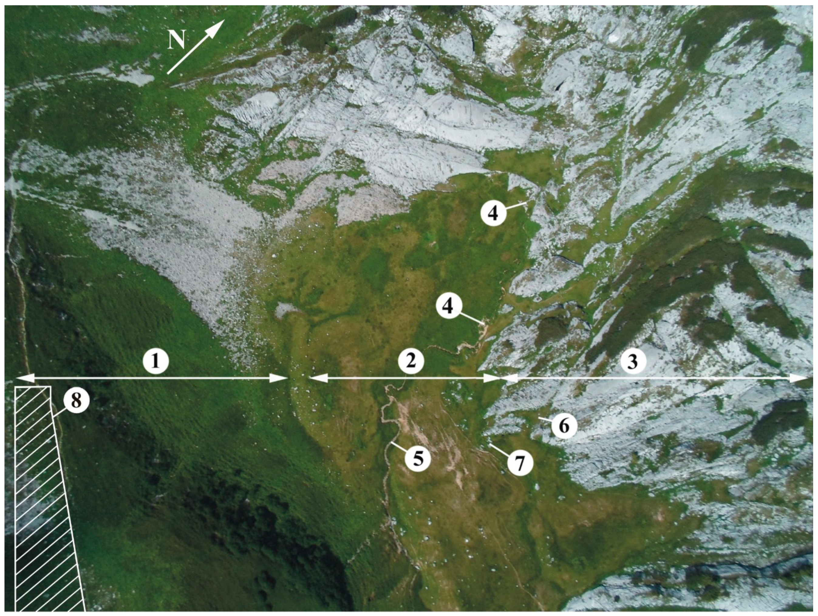
Figure 6. Aerial photograph of area IV under Wildgössl (cirque formed from paleouvala, Totes Gebirge): 1. Side of paleouvala with debris fans, 2. floor of paleouvala with superficial deposit, 3. slope of paleouvala with glacially eroded cuesta, 4. ponor, 5. gully, 6. covered karst terrain intruding into the depression of the cuesta, 7. a subsidence doline in the zone of thin superficial deposit next to rock boundary, 8. zone of springs.
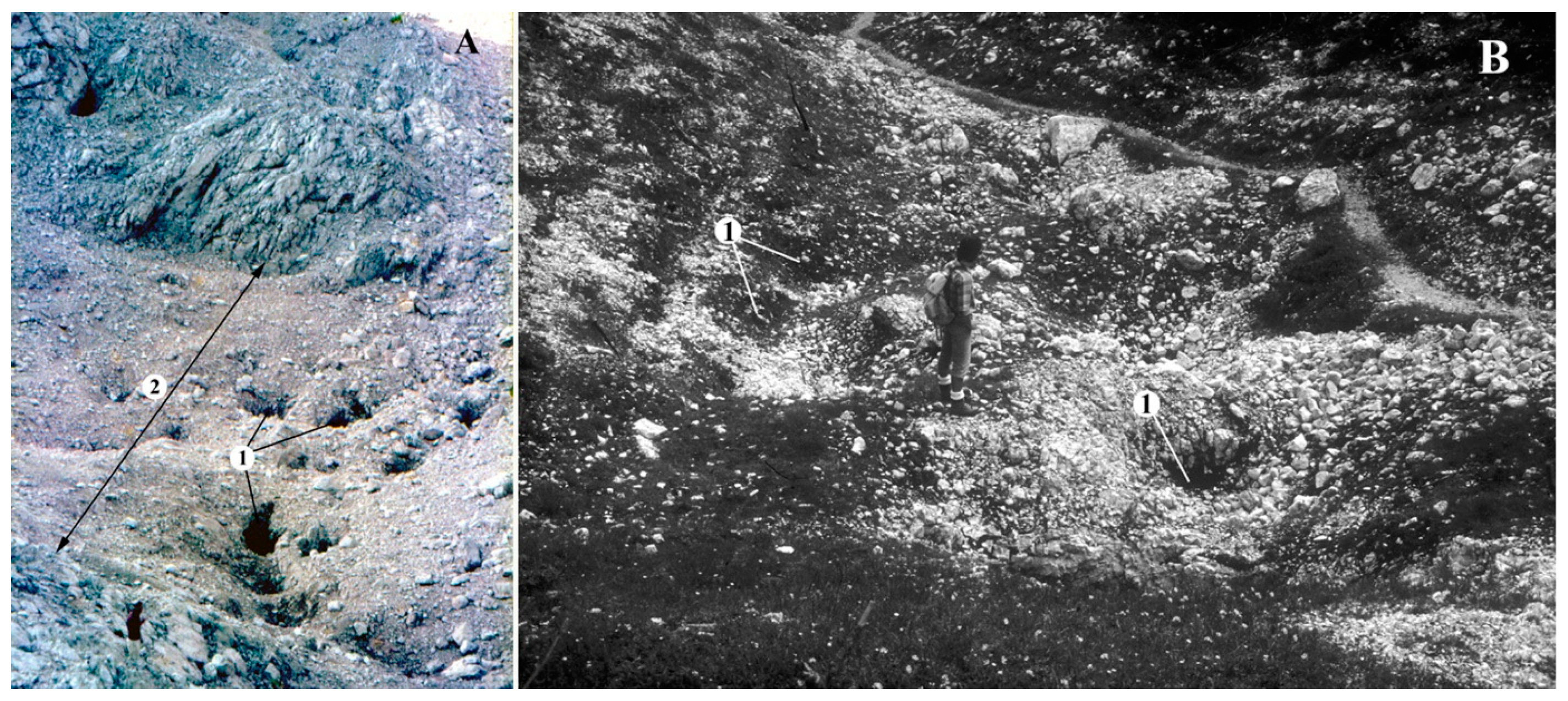
Figure 7. Suffosion dolines receiving till: (A) Suffosion dolines in the debris of a paleouvala (Julian Alps, near Triglav, Slovenia), (B) suffosion dolines from the floor of a glacial valley (Totes Gebirge, Austria). Legend: 1. Suffosion doline, 2. paleodoline.
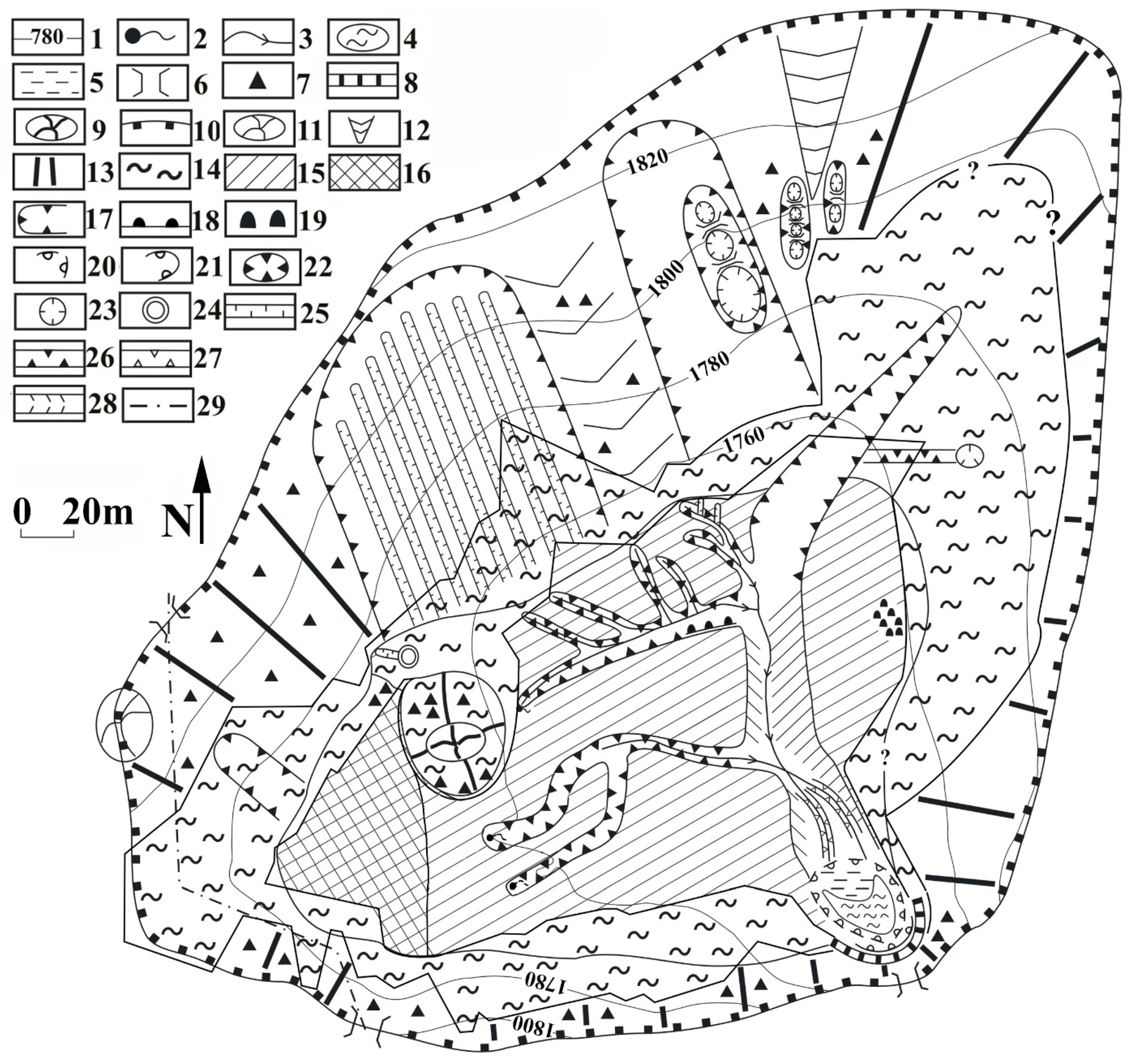
Figure 8. Geomorphological map of the DSD (exposing paleodoline) of Hochschwab [1]: 1. Contour line, 2., spring (permanent and intermittent), 3. stream, 4. lake, 5. waterlogged area, 6. col, 7. exposed limestone, 8. slide, 9. roche moutonnée or karstic residual feature, 10. edge of the DSD, 11. mound on the margin of the depression system, 12. limestone ridge, 13. denuded side slope of the depression, 14. accumulational slide slope of depression, 15. cryptokarstic part of the depression floor, 16. concealed karstic part of the depression floor, 17. nivation and mass movement features of the side slope, 18. slide (with mass movement), 19. thufur field, 20. infilled ponor, 21. active ponor, 22. recent uvala, 23. solution doline, 24. shaft, 25. rain furrow, 26. gully, 27. channel on valley floor, 28. valley, 29. tourist track.
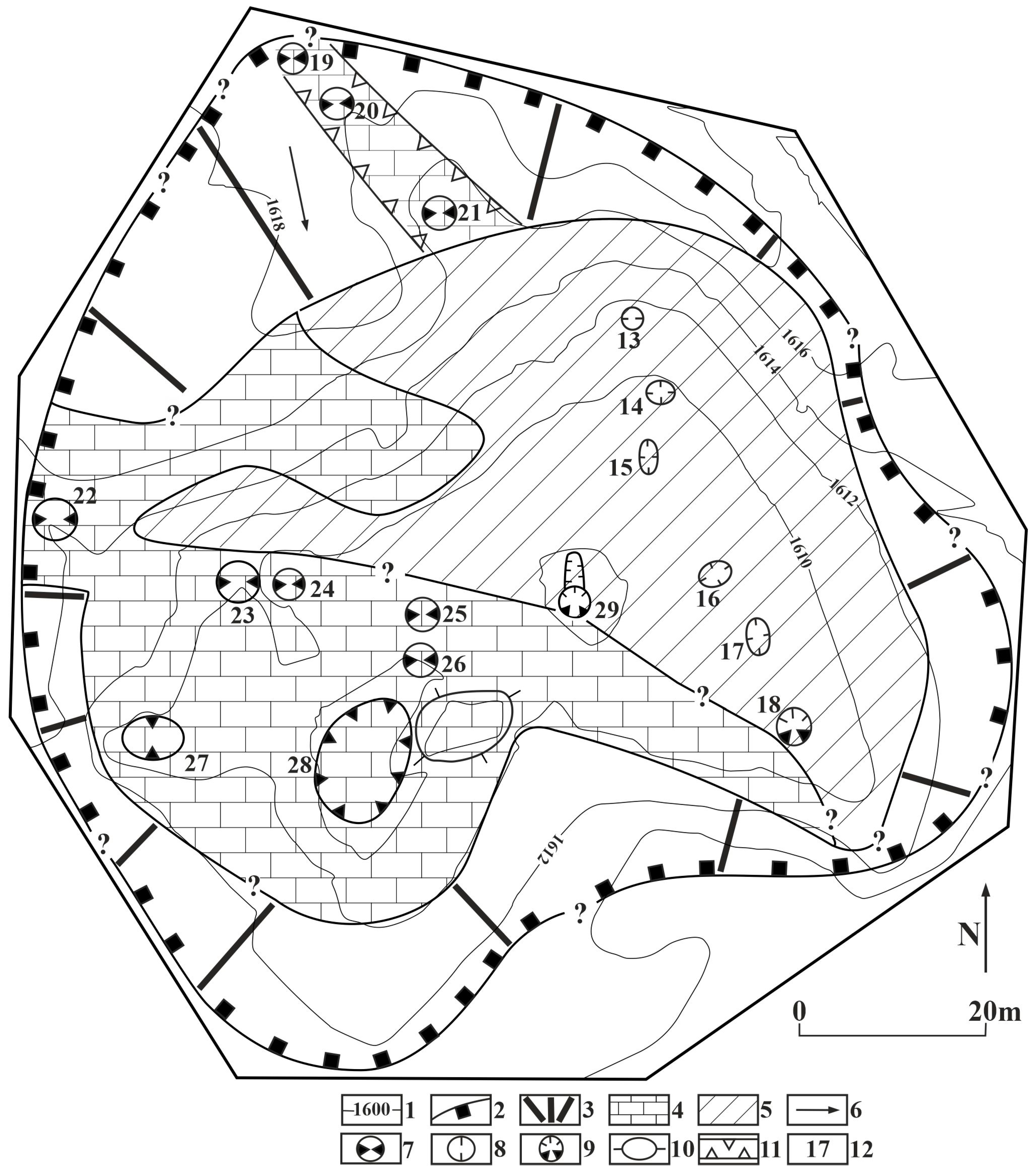
Figure 9. Map of the western part of the paleodoline near Tauplitz alm (Totes Gebirge) [1]: 1. Contour line, 2. paleodoline, 3. uncovered side slope of paleodoline, 4. uncovered floor of paleodoline, 5. covered floor of paleodoline, 6. dip direction of layer, 7. solution doline, 8. subsidence doline, 9. subsidence half-doline, 10. roche moutonnée, 11. solution giant grike, 12. identification code of doline.
2.3. Landscape Evolution of Bare Surfaces
From a certain altitude (in the Alps, from 1600 m), bare surfaces make up a larger and larger proportion of glacier valleys. These surfaces constitute a series of cuestas where scarp fronts and bedding planes are aligned above each other since the glacier tore bed sections out of their environments (Figure 1 and Figure 3B) [1]. The height of scarp fronts and the degree of the inclination of bedding planes are determined by the original bedding of the rock. The extension of bedding planes, which affects karren formation, is determined by glacial erosion in a way that glacial erosion peels bed sections of more and more elevated positions and thus, it enables the exposure of newer and newer bedding planes with larger and larger extensions. If the glacier was moving in the strike direction of the beds, the inclination of exposed bedding plane sections is perpendicular to the valley. Therefore, remnants of bedding plane sections may dip towards the axis or the margin of the valley depending on which parts of the beds became denuded (Figure 1b).
Karren formation is determined by the dip direction of the bedding plane, the degree of inclination, and as already mentioned, the extension of bedding planes. Karren formation takes place simultaneously on the bedding planes situated above each other in cuestas which are also situated above each other. The developing karren features may be the same, but different too if for example the extension and inclination of bedding planes is different. In the karren denudation of the surface, large-sized rinnenkarren (of type B) and channel systems (constituted by main valleys and tributary valleys) play a role. The water flowing in them transports dissolved material and debris into the karst.
At beds that are inclined towards the inner part of the valley, the water gets from the area of bedding planes to the bedding plane of the lower position. In this case, the water does not necessarily go into the karren, but it partly arrives at shafts, schachtdolines, and dolines. At a bedding plane that is inclined towards the margin of the valley, most of the water stays on this bedding plane or flows into the karren features that developed at the stem of the step of the bed situated above it.
Therefore, at bedding planes being inclined outwards, the karren formation of the bedding plane is more intensive than at beds which are inclined inwards if similar conditions are present. Since bedding planes with opposite dip directions may also be aligned on the opposite slopes of the valley, their karren formation and intensity of karren formation may be different. In the case of beds dipping outwards, karren formation may be concentrated at the stem of the scarp front, and to the bedding plane situated below the upper bed section. Giant grikes, pits, and Schichtfugenkarren develop at scarp fronts. Bed sections that are situated above Schichtfugenkarren may shift, which may increase the extension of a given bedding plane, and may decrease the extension of the bedding plane above it. However, giant grikes developing at scarp fronts may result in the separation of bedding plane parts situated above each other.
The deepening of some karren features results in the fact that the beds are gone transversely. Such karren features are rinnenkarren and grikes. Other karren features (e.g., kamenitzas, rillenkarren) cannot contribute to this because of their small vertical size. With the deepening of the karren feature, if they occur rarely and the bed is thin, the bed parts stay stable, the features may even develop in several beds. In the case of dense development and a larger bed inclination, the bed becomes separated from the bedrock and karren debris develops. Following the denudation of the karren debris, the development of the karren feature is repeated in the bedrock. Thus, newer and newer beds may be peeled. The debris accumulates on the lower bedding plane (in this case, it decreases by dissolution) or it is transported into shafts or grikes by meteoric water.
On bedding planes of lower inclination, rinnenkarren of type B and rinnenkarren systems develop (Figure 3B) [8]. Mainly these latter transmit the water from the complete catchment area of the rinnenkarren system into the pits of the main channel. Dissolution takes place not only in the karren features, but also on the surfaces between them. Consequently, areic features with large extensions but small depth, the karren cells are formed. These cells cause the areic character of complete bedding plane sections both in the case of bedding planes being inclined inwards or outwards. The slope with bedding planes becomes dissected by karren cells. In the areas of karren cells, the beds become peeled separately if the density of rinnenkarren and grikes is high enough there. Karren cells that developed near each other may be borne by bedding planes of different beds. Such a surface is dissected by the bedding planes of different beds instead of the bedding plane of a unique, originally existing bed.
At places where grikes of strike direction develop, the beds also become dissected and the remaining debris is transported into the giant grikes that were formed at the stems of scarp fronts by mass movement. The process and thus the denudation of a bed becomes particularly intensive if Schichtfugenkarren that fall in the dip direction of the beds occur at the stem of the step (Figure 10). The usual denudation of side slopes in the case of beds being inclined towards the inside and the margin of the glacier valley is described in Figure 11 and Figure 12.
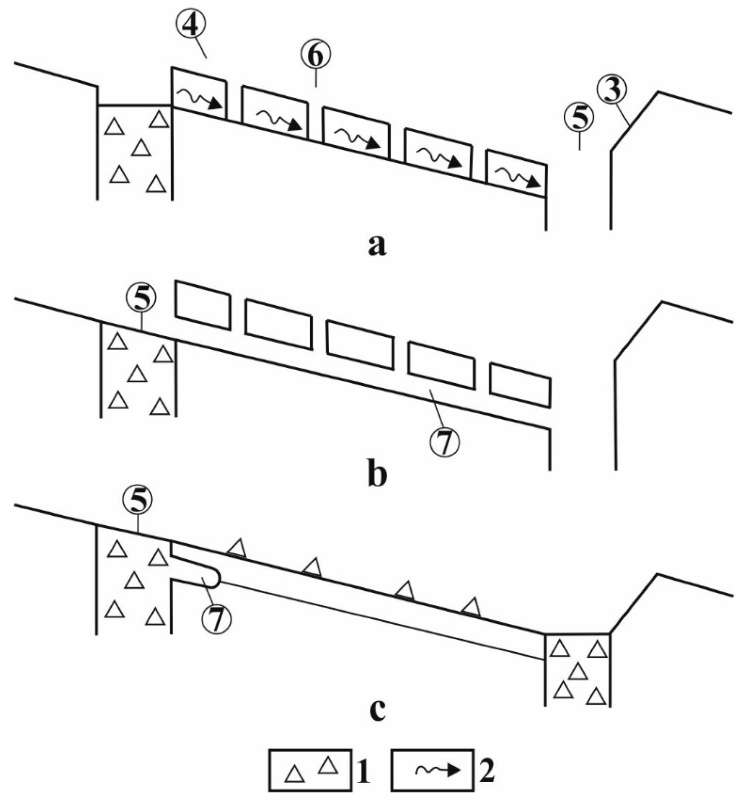
Figure 10. Peeling of the bed unit of a bed in case of grike-schichtfugenkarren assemblage [1]. 1. debris, 2. seepage, 3. scarp front, 4. surface with bedding plane, 5. giant grike, 6. grike, 7. Schichtfugenkarren, (a). grike development, (b). Schichtfugenkarren development, (c). the uppermost bed is separated into debris pieces, and a newer Schichtfugenkarren develops on the bedrock bed.
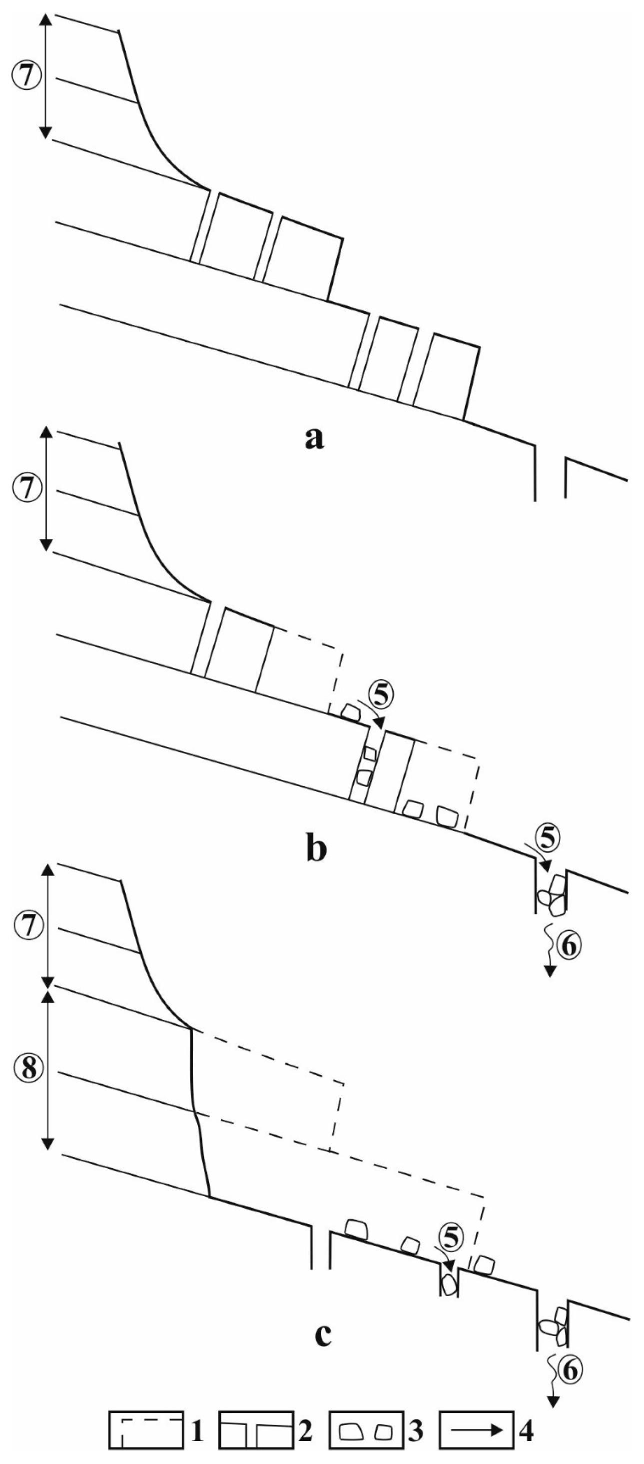
Figure 11. Development of the side slope of a trough when the beds are inclined towards the inner part of the valley [1]. Legend: (a). grikes develop in the two upper bed parts, (b). these bed parts are partially destroyed, (c). the bedding plane of the bedrock bed is exposed by the complete denudation of the two upper bed parts 1. Destroyed bed unit, 2. grike, 3. debris, 4. material transport, 5. material transport in debris, 6. material transport in solution, 7. slope formed by glacial erosion, 8. slope developed by peeling.
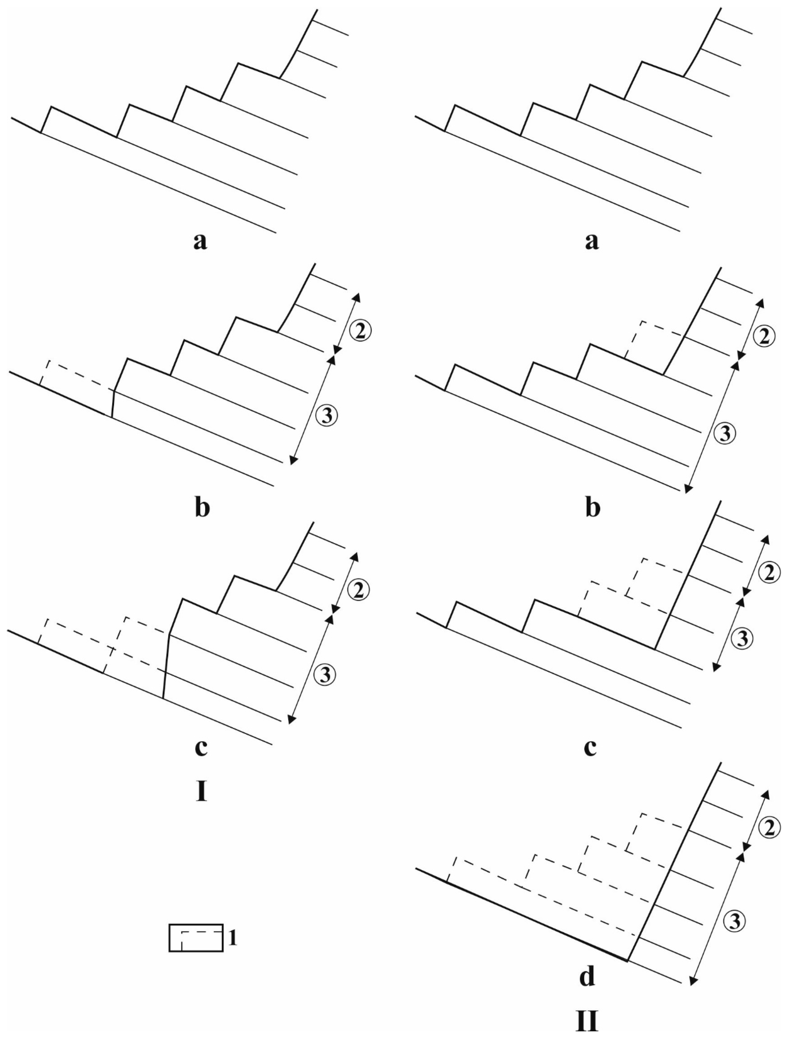
Figure 12. Geomorphic evolution (peeling) if the beds are inclined towards the margin of the slope, but the peeling of beds with lower position (I) or with upper position is faster (II) [1]: 1. Destroyed bed unit, 2. slope formed by glacial erosion, 3. slope formed by the peeling of the bed, (a). stepped surface, (Ia–IIa). original state, (Ib–Ic). beds are destroyed at lower steps, during this a widening bedding plane and a high scarp front develop, (IIb–IIc). the beds of upper steps are peeled more intensively, by which wider and wider bedding planes are exposed, (IId). only one bedding plane surface develops under the former stepped surface.
On bare slopes, as a result of karren water supply, the already existing epikarstic cavities may continue their development, become sediment receptors, and they may contribute to karren formation.
2.4. Surface Denudation by Dissolution
Material transportation on bare surfaces or surfaces covered with debris is described in Figure 13. On bare surfaces, karren formation and debris formation exert their effect together, but alternate and result in surface denudation. In addition to frost weathering debris, other debris develops from karren remnant features (karren knife edges, spitzkarren). Karren formation and the denudation of the bedrock surface stops when the covering limestone debris thickens out to such a degree that the saturation level is located in it. The cover with debris, due to the dissolution of its pieces, thins out; thus, the saturation level is placed into the bedrock again. In this case, a newer karren formation may begin [1][14] (Figure 14).
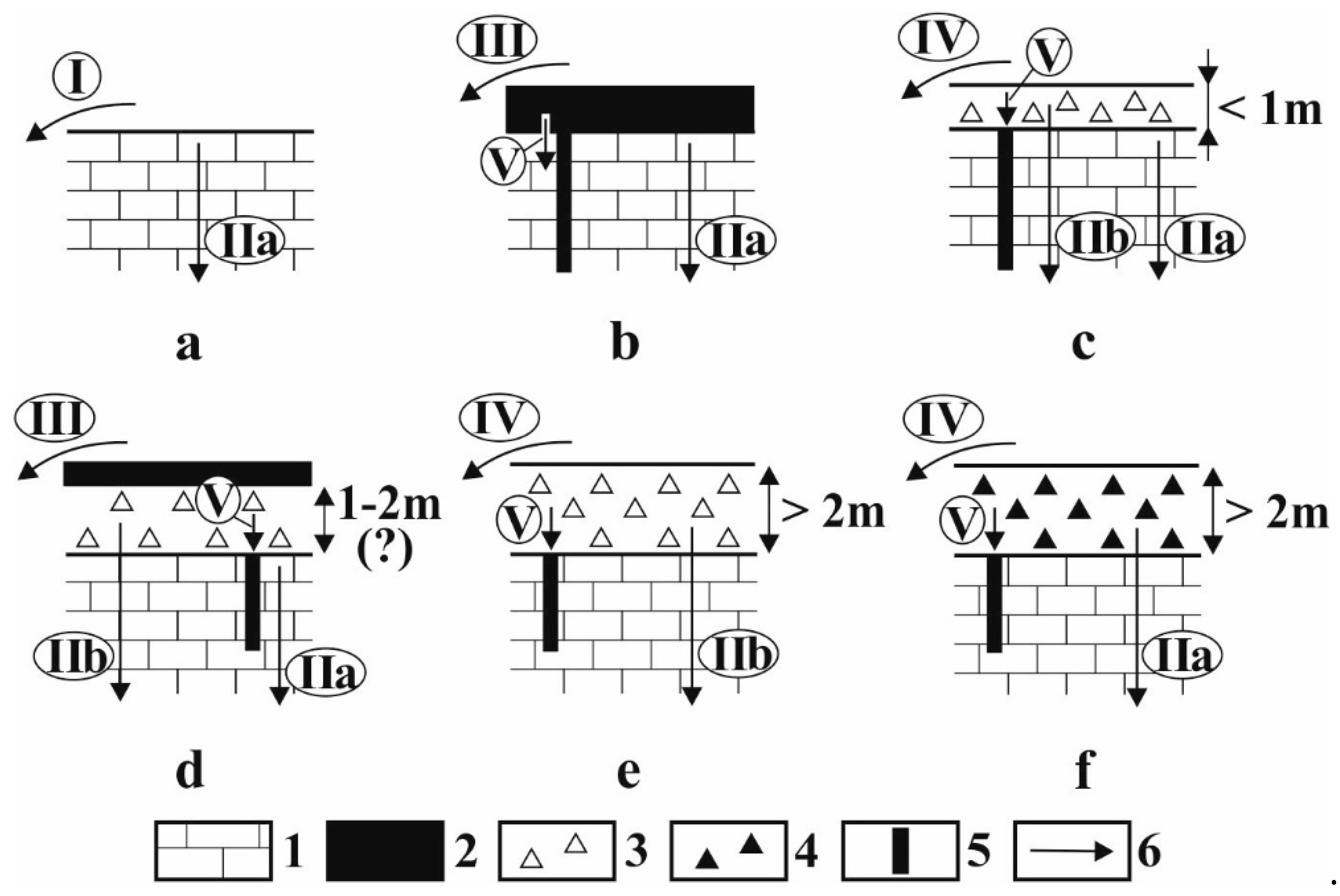
Figure 13. Ways of material transport on glaciokarst [1]: (a). Bare surface, (b). limestone surface covered with soil, (c). limestone surface covered with calcareous debris with a thickness smaller than 1 m, (d). terrain covered with soil and calcareous debris with a thickness of 1–2 m, (e). limestone surface covered with calcareous debris thicker than 2 m, (f). limestone surface covered with non-calcareous debris, 1. limestone, 2. soil, 3. calcareous debris, 4. non-calcareous debris, 5. karstic passage (karstic passages in figures (d–f). are of subglacial origin), 6. material transport, I. material transport in solution on the surface, II.a. material transport in solution from the limestone, II.b. material transport in solution from the debris, III. transportation away of soil on the surface by meteoric water, IV. fine-grained material transport on the surface by meteoric water, V. suffosional material transport into the karstic (karren) passages.
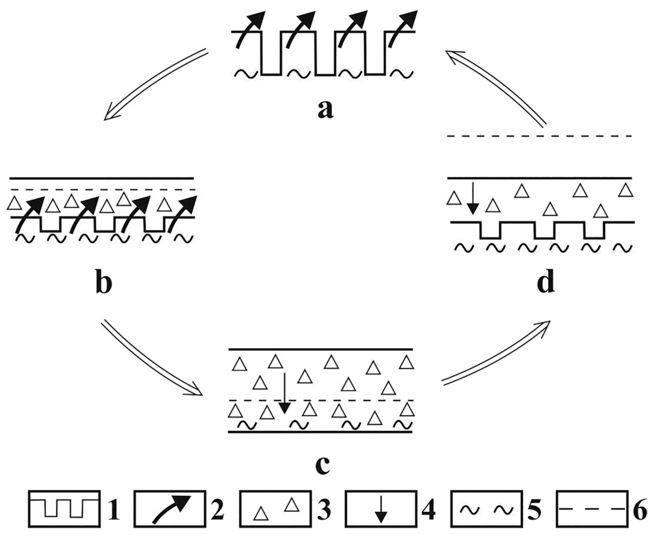
Figure 14. Denudation cycle with karren formation [1]: 1. Grike, 2. formation of karren debris, 3. karren debris, 4. the material of the debris is transported away in solution, 5. saturation level, 6. original surface, (a). grike development, (b). formation of karren debris (the surface is a bit elevated), (c). the debris thickens out, the saturation level is located on the bedrock surface, (d). the debris becomes thinner since its material is transported away in solution, the saturation level is situated in the bedrock, a newer generation of grikes develops, then a newer karren denudation cycle begins with the using up of debris.
On the mostly areic floor of cirques, shafts and subsidence dolines are predominant (Figure 15). On the side slopes of cirques, non-karstic processes operate. To the effect of frost weathering and mass movements, the slopes retreat and the cirque widens. Although on the floor, material transportation is significant to the karst, transportation into the cirque is more substantial; thus, these features become filled up (Figure 3A).
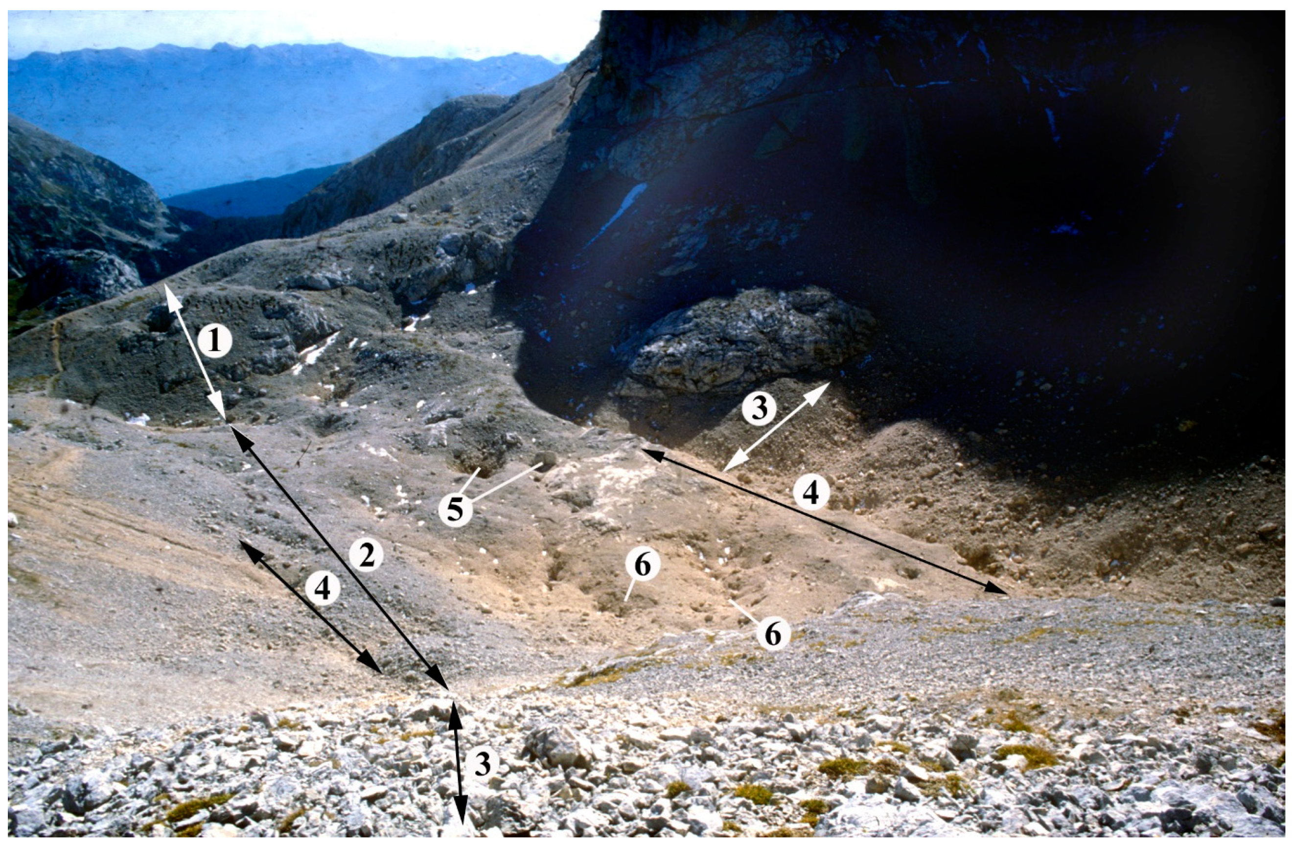
Figure 15. Covered karst features of the cirque below Triglav (Julian Alps): 1. counter-slope scarp (roche moutonnée), 2. covered karst in cirque, 3. debris fan of the cirque, 4. debris-covered giant grike with rows of subsidence dolines, 5. shafts, 6. subsidence dolines.
References
- Veress, M.; Telbisz, T.; Tóth, G.; Lóczy, D.; Ruban, D.A.; Gutak, J.M. Glaciokarsts; Springer Geography; Springer: Cham, Switzerland, 2019; 516p.
- Sweeting, M.M. Karst Landforms; Columbia University Press: New York, NY, USA, 1973; 362p.
- Ford, D.C. A review of alpine karst in the Southern Rocky Mountains of Canada. Bull. Natl. Speleol. Soc. 1979, 41, 53–65.
- Smart, C. Glacierized and glaciated karst. In Encyclopedia of Caves and Karst Science; Gunn, J., Ed.; Fitzroy-Dearborn: New York, NY, USA; London, UK, 2004; pp. 389–390.
- Ford, D.C.; Williams, P.W. Karst Hydrogeology and Geomorphology; John Wiley and Sons, Ltd.: Chichester, UK, 2007; 562p.
- Veress, M. Karst Environments—Karren Formation in High Mountains; Springer: Dordrecht, The Netherlands; Heidelberg, Germany; London, UK; New York, NY, USA, 2010; 230p.
- Hubbard, B.; Hubbard, A. Bedrock surface roughness and the distribution of subglacially precipitated carbonate deposits implications for formation at Glacier de Transfleuron, Switzerland. Earth Surf. Process. Landf. 1998, 23, 261–270.
- Veress, M. Karren and karren formation of bare slopes. Earth Sci. Rev. 2019, 188, 279–290.
- Veress, M. Covered Karsts; Springer: Berlin/Heidelberg, Germany; New York, NY, USA, 2016; 536p.
- Williams, P.W. Limestone pavements: With special reference to Western Ireland. Trans. Inst. Br. Geogr. 1966, 40, 155–172.
- Jones, R.J. Aspects of the biological weathering of limestone pavement. Proc. Geol. Assoc. 1965, 76, 421–433.
- Trudgill, S.T. Limestone Geomorphology; Longman: New York, NY, USA, 1985; 196p.
- Corbel, J. Les Karsts du Nord—Ouest de l’ Europe et de Quelques Regions de Comparaison: Etude sur le Rȏle du Climat dans l’ Erosion des Calcaires; Mémoires et Documents 12; Institut des Etudes Bhodaniennes de l’ Université de Lyon: Lyon, France, 1957.
- Ford, D.C. Genetic classification of solutional cave systems. In Proceedings of the 7th International Congress of Speleology, Sheffield, UK, September 1977; pp. 189–192.
- Ford, D.C. Karst groundwater activity and landform genesis in modern permafrost regions of Canada. In Groundwater as a Geomorphic Agent; LaFleur, R.G., Ed.; Allen & Unwin: London, UK, 1984; pp. 340–350.
- Gams, I. The polje: The problem of definition. Z. Für Geomorphol. 1978, 22, 170–181.
- Kunaver, J. Geomorphology of the Kanin Mountains with special regard to the glaciokarst. Geogr. Zb. 1983, 22, 201–343.
- Kunaver, J. Kotlič—A Special Depression of Subnival Alpine Karst. In Proceedings of the 6th International Congress of Speleology, Academia Praha, Brno, Czech Republic, 21–28 July 1996; pp. 223–230.
- Telbisz, T.; Dragašice, H.; Nagy, B. A karst morphological analysis of the Croatian Biokovo Mountains based on field observations and digital relief analysis. In Karsztfejlődés X; 2005; pp. 229–243. (In Hungarian)
- Klimchouk, A.; Bayari, S.; Nazik, L.; Tork, K. Glacial destruction of cave systems in high mountains, with a special reference to the Aladaglar Massif, Central Taurus, Turkey. Acta Carsologica 2006, 35, 7–21.
- Plan, L.; Decker, K. Quantitative karst morphology of the Hochschwab plateau, Eastern Alps, Austria. Z. Für Geomorphol. 2006, 147, 29–56.
- Žebre, M.; Stepišnik, U.; Colucci, R.R.; Forte, E.; Monegato, G. Evolution of a karst polje influenced by glaciation: The Gomance piedmont polje (Northern Dinaric Alps). Geomorphology 2016, 257, 143–154.
- Stepišnik, U.; Ferk, M.; Kodelja, B.; Medenjak, G.; Mihevc, A.; Natek, K.; Žebre, M. Glaciokarst of western Orjen, Montenegro. Cave Karst Sci. 2010, 36, 21–28.
- Zebre, M.; Stepišnik, U. Glaciokarst landforms and processes of the southern Dinaric Alps. Earth Surf. Process. Landf. 2015, 40, 1493–1505.
- Žebre, M.; Stepišnik, U. Glaciokarst geomorphology of the Northern Dinaric Alps: Snežnik (Slovenia) and Gorski Kotar (Croatia). J. Maps 2015, 12, 873–881.
- Veress, M. Subsidence dolines of Glaciokarst. In Horizons in Earth Science Research; Veress, B., Szigethy, J., Eds.; Nova Science Publishers: Hauppauge, NY, USA, 2017; Volume 16, pp. 101–120. ISBN 978-1-53611-893-3.
- Plan, L. Karstwasserschutz und Andere Umweltrelevante Fragestellungen im Bereichrax, Schneeberg und Hochswab; Projeketbericht; Umweltdachverband: Vienna, Austria, 2005.
- Adamson, K.R.; Woodward, J.C.; Hughes, P.D. Glaciers and rivers: Pleistocene uncoupling in a Mediterranean mountain karst. Quat. Sci. Rev. 2014, 94, 28–43.
- Bočič, N.; Faivre, S.; Kovacic, M.; Horvatincic, N. Cave development under the influence of Pleistocene glaciation in the Dinarides—An example from Štirovača Ice Cave (Velebit Mt., Croatia). Z. Für Geomorphol. 2012, 56, 409–433.
- Harbor, J.M.; Hallet, B.; Raymond, C.F. A numerical model of landform development by glacial erosion. Nature 1988, 333, 347–349.
- Barrére, P. Le relief karstique dans l’ouest des Purénées centrales. Revue Belge de Geographie. Ed. Soc. R. Geogr. Spec. Publ. Karst Clim. Froids 1964, 88, 9–62.
- Haynes, V.M. The influence of glacial erosion and rock structure on corries in Scotland. Geogr. Ann. 1968, 50, 221–234.
- Djurović, P.; Petrović, A.S.; Simić, S. The overall impact of Pleistocene glaciation on morphologicaldiversity of uvalas at Durmitor and Žijovo. Serbian Geogr. Soc. 2010, 90, 17–34.
- Fels, E. Das Problem der Karbildung in den Ostalpen. In Dr. A. Petermanns Mitteilungen. Ergänzungsheft Nr.; Justus Perthes: Gotha, Germany, 1929; Volume 202, pp. 1–84.
- Smart, C. Origin and development of glacio-karst closed depressions in de Europa, Spain. Z. Für Geomorphol. 1986, 30, 423–443.
More
Information
Subjects:
Geography, Physical
Contributor
MDPI registered users' name will be linked to their SciProfiles pages. To register with us, please refer to https://encyclopedia.pub/register
:
View Times:
628
Revisions:
2 times
(View History)
Update Date:
20 Oct 2023
Table of Contents


Notice
You are not a member of the advisory board for this topic. If you want to update advisory board member profile, please contact office@encyclopedia.pub.
OK
Confirm
Only members of the Encyclopedia advisory board for this topic are allowed to note entries. Would you like to become an advisory board member of the Encyclopedia?
Yes
No
${ textCharacter }/${ maxCharacter }
Submit
Cancel
Back
Comments
${ item }
|
${ item.createdUser.fullName }
${ item.createdAt }
${ item.vote }
${ item.reply }
Delete
${ reply.createdUser.fullName }
${ reply.createdAt }
${ reply.vote }
Delete
There is no reply to this comment~
${ item.replyTextCharacter }/${ item.replyMaxCharacter }
Submit
Cancel
More
No more~
There is no comment~
${ textCharacter }/${ maxCharacter }
Submit
Cancel
${ selectedItem.replyTextCharacter }/${ selectedItem.replyMaxCharacter }
Submit
Cancel
Confirm
Are you sure to Delete?
Yes
No