Your browser does not fully support modern features. Please upgrade for a smoother experience.
Submitted Successfully!
 +1 credit
Thank you for your contribution! You can also upload a video entry or images related to this topic.
For video creation, please contact our Academic Video Service.
| Version | Summary | Created by | Modification | Content Size | Created at | Operation |
|---|---|---|---|---|---|---|
| 1 | Olivier Merle | -- | 1864 | 2023-09-23 10:59:06 | | | |
| 2 | Catherine Yang | Meta information modification | 1864 | 2023-09-25 03:04:00 | | |
Video Upload Options
We provide professional Academic Video Service to translate complex research into visually appealing presentations. Would you like to try it?
Cite
If you have any further questions, please contact Encyclopedia Editorial Office.
Merle, O.; Boivin, P.; Langlois, E.; De Larouzière, F.; Michelin, Y.; Olive, C. The UNESCO Site of the Chaîne des Puys. Encyclopedia. Available online: https://encyclopedia.pub/entry/49557 (accessed on 26 July 2026).
Merle O, Boivin P, Langlois E, De Larouzière F, Michelin Y, Olive C. The UNESCO Site of the Chaîne des Puys. Encyclopedia. Available at: https://encyclopedia.pub/entry/49557. Accessed July 26, 2026.
Merle, Olivier, Pierre Boivin, Eric Langlois, François-Dominique De Larouzière, Yves Michelin, Cécile Olive. "The UNESCO Site of the Chaîne des Puys" Encyclopedia, https://encyclopedia.pub/entry/49557 (accessed July 26, 2026).
Merle, O., Boivin, P., Langlois, E., De Larouzière, F., Michelin, Y., & Olive, C. (2023, September 23). The UNESCO Site of the Chaîne des Puys. In Encyclopedia. https://encyclopedia.pub/entry/49557
Merle, Olivier, et al. "The UNESCO Site of the Chaîne des Puys." Encyclopedia. Web. 23 September, 2023.
Copy Citation
The tectono-volcanic ensemble of the Chaîne des Puys and the Limagne fault, which is part of the West European rift, was inscribed on the UNESCO World Heritage list in 2018 as the Chaîne des Puys–Limagne fault tectonic arena.
world heritage
UNESCO
rift
volcanoes
Chaîne des Puys
1. Introduction
The pure and simple lines of the natural topographic features of the tectono-volcanic ensemble of the Chaîne des Puys and the Limagne Fault are already very majestic in themselves. But, clearly, its geological dimension amplifies the aesthetic value of this landscape. Before Guettard demonstrated the volcanic origin of the Chaîne des Puys in the mid-18th century, early visitors to the area considered them simply as gentle hills. Nowadays, thanks to the abundance of scientific knowledge available to visitors to the site, the diversity of geomorphological shapes can be clearly linked to their specific tectonic and volcanological origins, which make them both highly educational and visually emblematic and moving. Every year, half a million tourists, students and researchers come to visit and study this renowned geoheritage site. Geotourism is a major asset to the Auvergne region, with well-known attractions such as the volcano theme park Vulcania, the summit of the puy de Dôme volcano and the museum showcasing the open-air dyke-feeding system of Lemptegy volcano. Located in the very heart of the Chaîne des Puys, these three major sites blend entertainment with education. They provide the means for the general public to learn more about the Earth’s history and natural processes operating on it, attracting large numbers of visitors annually (around 150,000 for Lemptegy and almost 400,000 for the puy de Dôme).
2. The Chaîne des Puys: Central to the Debate about the Ancient Theories of the Earth’s Formation
Western Europe in general, and Auvergne volcanism in particular, with its spectacular Chaîne des Puys, was the site of the first debates in the 18–19th centuries concerning the origin of volcanic rocks and theories of the Earth’s formation. These two scientific questions were closely linked.
Abraham Gottlob Werner developed the Neptunist theory in the late 18th century based on the stratification of the Earth’s crust. According to him and his passionate followers, rocks were formed in a “primitive ocean” by precipitation. Hence, for the Neptunists, granites and basalts were sediments deposited at the bottom of ancient seas that had since disappeared, at best the result of the underground combustion of coal. In this theory, the volcanic origin of basalts was totally misunderstood.
At almost the same time, James Hutton propounded the plutonism theory in his famous book Theory of the Earth [1]. Based on observations in Scotland and the Auvergne, he put forward the idea that volcanoes act as safety valves for the release of excess heat inside the Earth. This work marked the real beginning of the rivalry between the Plutonists, who defended this point of view after James Hutton’s death, and supporters of the opposite theory, of which Werner was the leader, called the Neptunists.
In this context, extinct volcanoes had an important role to play. Did basalts, such as those observed in the Auvergne and the Chaîne des Puys, initially form as sediments in the sea, or did they result from aerial eruptions of magma coming from the interior of the Earth?
In 1752, Jean-Étienne Guettard was the first to establish the volcanic origin of the Chaîne des Puys [2]. This major discovery was followed by the study of Nicolas Desmarest (1771), who showed that most rocks in the region originate from volcanic eruptions [3]. He confirmed this fact by pointing out baked soils beneath flows that had been affected by the passage of these flows, and the lateral continuity of columnar basalts with the scoriaceous surface of the same lava flows.
Based on these significant discoveries and interpretations, researchers working in the Auvergne and the Chaîne des Puys found themselves in the camp of the proponents of the plutonism theory. Thus, Montlosier, after having travelled through this area and observed in detail many of the outcrops and the landscape, invited foreign scientists, mainly of the Neptunist camp, to the Auvergne to convert them [4]. Likewise, in the 18th century, Déodat de Dolomieu, following his experience of Italian and Sicilian volcanoes, invoked the existence of hot, viscous material deep beneath the Earth’s granitic consolidated crust in the Auvergne. In his view, basalt was once molten rock.
The debate raged over decades between the two schools of thought. The first volcanology textbooks [5] (Figure 1) seriously weakened the Neptunist theory, which was abandoned shortly afterward. Today, it is difficult to imagine the violence of the verbal jousts between the Neptunists and Plutonists. In this fierce battle, the Auvergne volcanoes, particularly those of the Chaîne des Puys, were the scene of several great debates and controversies that led to the emergence of modern volcanology.
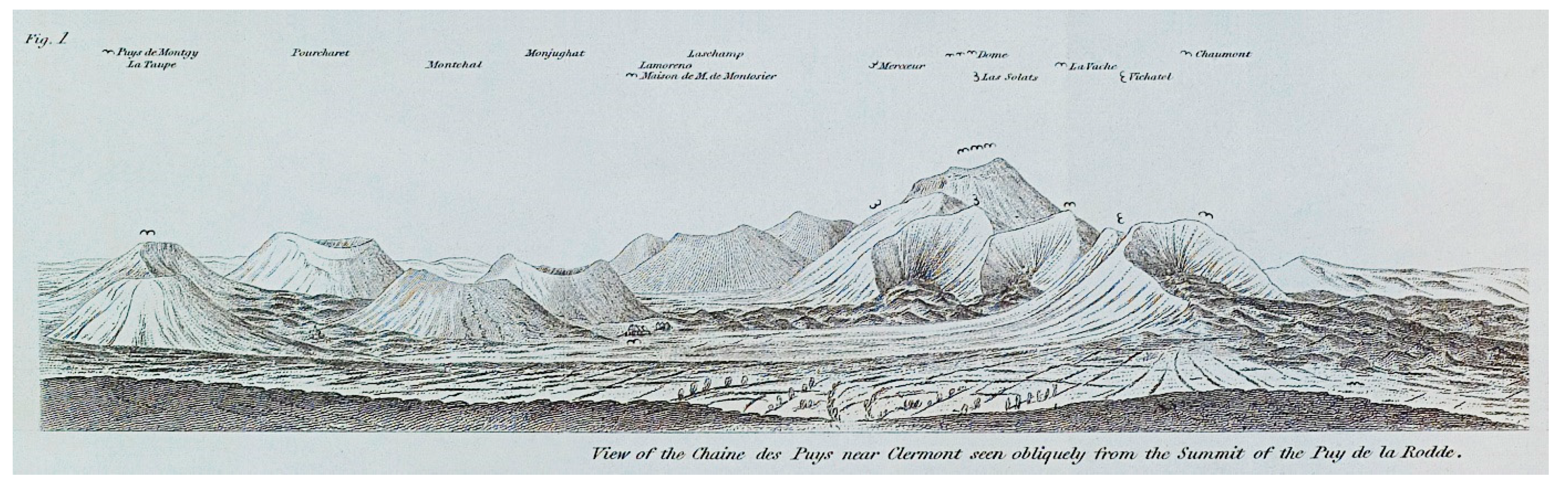
Figure 1. Hand-drawn sketch of the Chaîne des Puys by Scrope from the early eighteenth century. Illustrating the importance of pastoralism, which declined at the turn of the 19th/20th century, note that the Chaîne des Puys was not covered by forest at that time.
3. The Volcanic Alignment of the Chaîne des Puys
The Chaîne des Puys is the result of a series of monogenic eruptions aligned roughly parallel to the Great Limagne Fault that demarcates the Limagne rift to the west. The volcanoes are located on the western shoulder of this rift, about 7 km to the west. The main group, listed as a UNESCO World Heritage Site, consists of about 80 closely associated volcanoes over a global N-S length of 25 km (Figure 2). A few isolated volcanic edifices are found to the north and south over a total distance of 42 km.
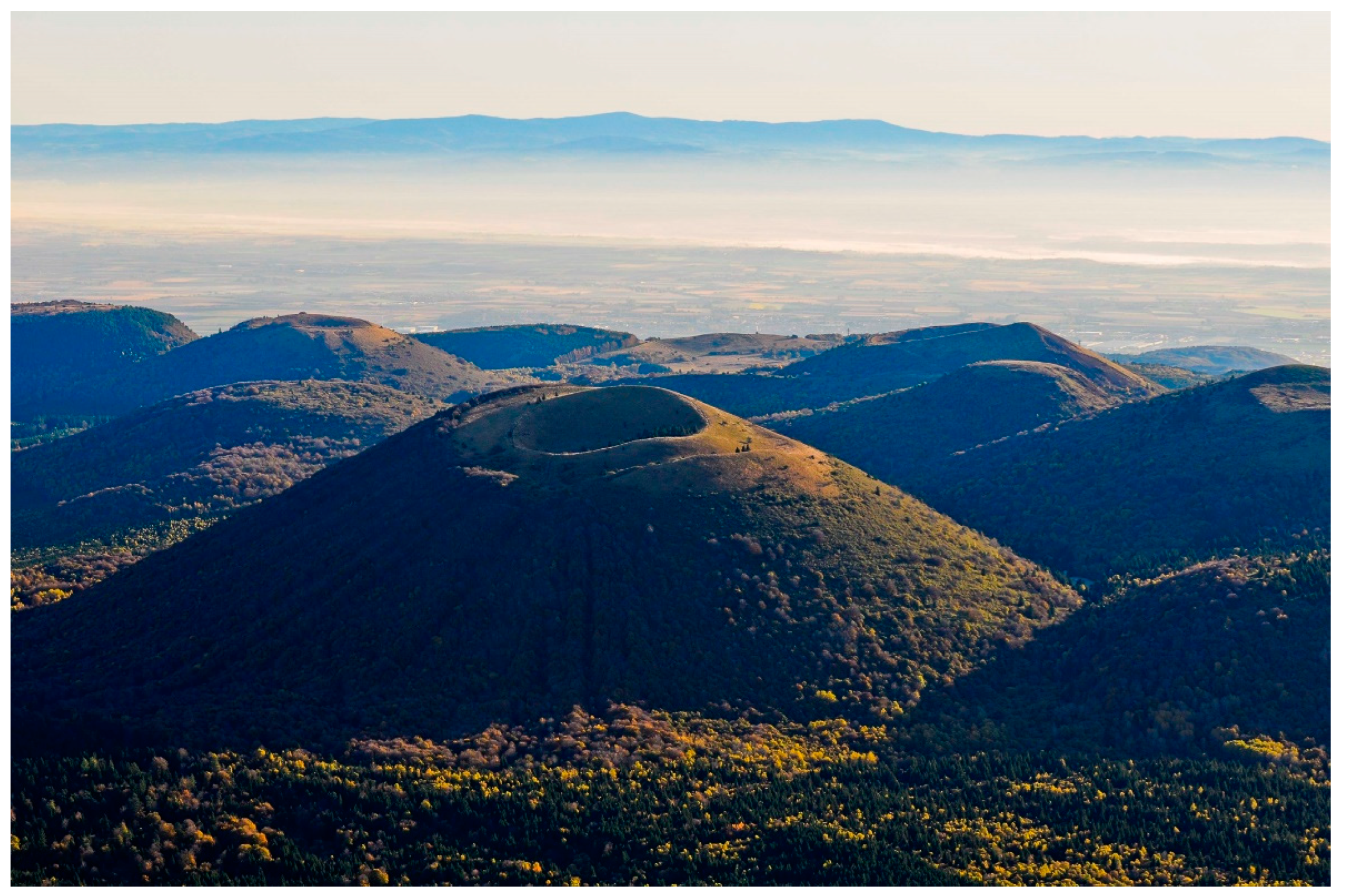
Figure 2. A view to the east from the Plateau des Dômes. The volcanoes of the Chaîne des Puys overlook the Limagne graben in the summer mist. In the background, the mountains of the Monts du Forez mark the eastern edge of the Limagne graben (the eastern shoulder of the graben).
The Chaîne des Puys volcanoes are aligned along ancient Variscan faults (older than 300 Ma) demonstrating that these crustal discontinuities were re-used in the Quaternary as conduits during the ascent of the magma. Most volcanoes are arranged along a major fault, which forms the backbone of the Chaîne des Puys and lies parallel to the Limagne Fault (Figure 3). Other volcanoes occur along a series of secondary faults, all Variscan, connected to the main fault and oriented N10E/N20E in the north and NW-SE in the south [6].

The Chaîne des Puys volcanic activity began about 100 ka ago and ended only 8600 years ago (La Vache and Lassolas puys) [7]. During this period, three peaks of activity can be distinguished, the first around 60 ka, the second between 40 and 45 ka and the last between 10 and 15 ka (Figure 4). However, sampling bias due to a number of reasons cannot be ruled out. Firstly, while the recent eruptions have been exhaustively inventoried, not all the old eruptions have been dated, not to mention those whose products are buried under more recent deposits. Further, the peak at 40 ka could also be explained by recent specific work to document the geomagnetic anomaly of the Laschamps excursion [8]. Finally, the search for tephra in wetlands and peat bogs on a regional scale makes it possible to date recent events that are not necessarily relevant on the scale of the volcanic chain as a whole [9].

Figure 4. Chronology of the eruptions of the Chaîne des Puys and composition of their lavas.
The magmas of the Chaîne des Puys are a prime example of a series of differentiation by fractional crystallization and are commonly used in the teaching of magmatology. The series is remarkably complete and uninterrupted in terms of differentiation, with alkaline basalts, trachy-basalts, basaltic trachy-andesites, trachy-andesites and trachytes. The magmas are inferred to have formed in a large infracrustal chamber where mantle magmas collected and mixed and underwent early evolution [10]. They were periodically released to the surface or injected into intermediate chambers where further differentiation took place, potentially leading to zonation of the reservoirs or additional mixing. It is the large, narrow and N-S elongated infracrustal chamber parallel to the Great Limagne Fault, which has determined the layout of the volcanoes of the Chaîne des Puys at the surface.
Eruptions of the different lavas emitted have produced characteristic morphologies that directly reflect their nature, as found elsewhere in the world. Their diversity explains the variety of volcanic forms in the Chaîne des Puys. As the silica content increases, the lava becomes more viscous and enriched with gas, raising its explosiveness [11]. Strombolian cones with gentle slopes form from the more basaltic lava, then as the composition evolves, the lava flows become thicker and the flank angles steeper. Finally, at the trachyte stage, in addition to pyroclastic flows, the lava builds domes of different shapes from rounded forms to protrusions [12][13][14]. Shallow intrusions have also been identified, which can affect the topography while not having any surface outcrop [15], and the use of atmospheric muon tomography has made it possible to image the internal structure of edifices [16][17]. The magmatic dynamics of these eruptions were quite often affected near the surface by interaction with groundwater, especially at the beginning of eruptive phases, triggering phreatomagmatic eruptions and giving rise to maars, some of which are still occupied by wetlands (Narse d’Espinasse and Beaunit).
Activity at a Strombolian cone involves low-viscosity magma, with the magma occurring as a gas–liquid mixture. Explosions of the volcanic gas bubbles at the surface of the volcano feeder conduit throw incandescent lava of all sizes into the air. These projectiles are scattered in all directions and, after a short parabolic trajectory, they fall back to the ground. The accumulation of this material results in a cone around the conduit, which, in an ideal case, is perfectly regular and has a round summit crater (Figure 5). Strombolian activity is generally weakly explosive and is often accompanied by effusive activity with the formation of one or more lava flows.
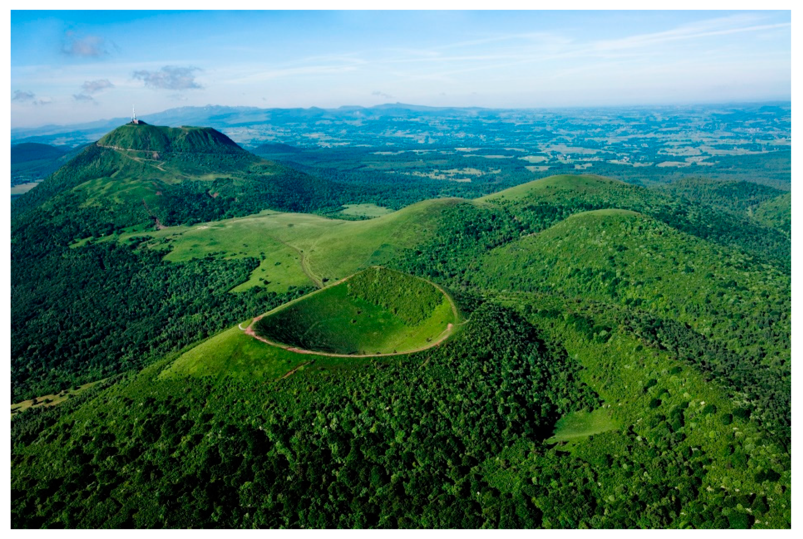
Figure 5. The puy de Pariou, in the foreground, is the emblematic example of a Strombolian cone in the Chaîne des Puys. In the background, the puy de Dôme is a cumulo-dome, resulting from the superposition and nesting of several successive domes (© P. Soissons).
A dome results from the accumulation of highly viscous lava at the ground surface, which spreads laterally under its own weight combined with the ongoing supply of magma. The shape of the dome depends on the viscosity of the lava. If it is moderately viscous, the dome will be very spread out around its feeder conduit, with a fairly flat top surface. If the lava is extremely viscous, its height will increase, its slopes will become steeper and its top more angled (Figure 5). With hyper-viscous magma, at the extreme end of this scale, it can produce protrusions where the lava no longer spreads laterally but instead rises vertically above the feeder pipe.
References
- Hutton, J. Theory of the Earth, with Proofs and Illustrations; Cadell and Davies: Edinburgh, Scotland, 1795; Volume I.
- Guettard, J.E. Mémoire sur Quelques Montagnes de la France qui ont été des Volcans; Mémoires de l’Académie Royale des Sciences: Paris, France, 1752; pp. 27–59.
- Desmarest, N. Mémoire sur L’origine et la Nature du Basalte à Grandes Colonnes Polygones, Déterminées par L’histoire Naturelle de Cette Pierre, Observée en Auvergne; Mémoires de l’Académie Royale des Sciences: Paris, France, 1771; Volume 3, pp. 599–670.
- Montlosier, F.-D. Essai sur la Théorie des Volcans d’Auvergne; Landriot & Rousset Edit: Clermont-Ferrand, France, 1788.
- Scrope, G.P. Considerations on Volcanos, the Probable Causes of Their Phenomena, the Laws Which Determine Their March, the Disposition of Their Products, and Their Connexion with the Present State and Past History of the Globe, Leading to the Establishment of a New Theory of the Earth; Phillips & Yard Pub. Edit.: London, UK, 1825.
- Merle, O.; Aumar, C.; Labazuy, P.; Merciecca, C.; Buvat, S. Structuration tertiaire et quaternaire du Plateau des Dômes (Chaîne des Puys, Massif Central, France). Geol. Fr. 2023, 1, 1–22.
- Boivin, P.; Besson, J.-C.; Briot, D.; Deniel, C.; Gourgaud, A.; Labazuy, P.; Langlois, E.; Larouzière, F.-D.; Livet, M.; Merciecca, C.; et al. Volcanologie de la Chaîne des Puys Massif Central Français, 6th ed.; Bilingue; Édition Parc Naturel Régional des Volcans d’Auvergne Château de Montlosier: Aydat, France, 2017; 200p.
- Laj, C.; Guillou, H.; Kissel, C. Dynamics of the Earth magnetic field in the 10–75 kyr period comprising the Laschamp and Mono Lake excursions: New results from the French Chaîne des Puys in a global perspective. Earth Planet. Sci. Lett. 2014, 387, 184–197.
- Jouannic, G.; Walter-Simonnet, A.-V.; Bossuet, G.; Boivin, P.; Cubizolle, H.; Delabrousse, E.; Develle, A.-L.; Devidal, J.-L.; Oberlin, C.; Pigny, B. Developing and expanding the Late-Glacial and Holocene tephrochronological framework of France: A new contribution from the Chaîne des Puys volcanic field in the Massif Central. Quat. Int. 2022, 636, 81–95.
- Martel, C.; Champallier, R.; Prouteau, G.; Pichavant, M.; Arbaret, L.; Balcone-Boissard, H.; Boudon, G.; Boivin, P.; Bourdier, J.-L.; Scaillet, B. Trachyte phase relations and implication for magma storage conditions in the Chaîne des Puys (French Massif central). J. Pet. 2013, 54, 1071–1107.
- Jordan, S.; Le Pennec, J.L.; Gurioli, L.; Roche, O.; Boivin, P. Highly explosive eruption of the monogenetic 8.6 ka BP La Vache et Lassolas scoria cone complex (Chaîne des Puys, France). J. Volcanol. Geotherm. Res. 2016, 313, 15–28.
- Miallier, D.; Pilleyre, T.; Boivin, P.; Labazuy, P.; Gailler, L.-S.; Rico, J. Grand Sarcoui volcano (Chaîne des Puys, Massif Central, France), a case study for monogenetic trachytic lava domes. J. Volcanol. Geotherm. Res. 2017, 345, 125–141.
- Colombier, M.; Shea, T.; Burgisser, A.; Druitt, T.H.; Gurioli, L.; Müller, D.; Cáceres, F.; Hess, K.-U.; Boivin, P.; Miallier, D.; et al. Rheological change and degassing during a trachytic Vulcanian eruption at Kilian Volcano, Chaîne des Puys, France. Bull. Volcanol. 2020, 82, 78.
- Deniel, C.; Boivin, P.; Miallier, D.; Gerbe, M.-C. Multi-stage growth of the trachytic lava dome of the Puy de Dôme (Chaîne des Puys, France). Field, geomorphological and petro-geochemical evidence. J. Volcanol. Geotherm. Res. 2020, 392, 106749.
- van Wyk de Vries, B.; Márquez, A.; Herrera, R.; Bruña, J.L.G.; Llanes, P.; Delcamp, A. Craters of elevation revisited: Forced-folds, bulging and uplift of volcanoes. Bull. Volcanol. 2014, 76, 875.
- Barnoud, A.; Cayol, V.; Lelièvre, P.G.; Portal, A.; Labazuy, P.; Boivin, P.; Gailler, L. Robust Bayesian joint inversion of gravimetric and muographic data for the density imaging of the Puy de Dôme volcano (France). Front. Earth Sci. 2020, 8, 575842.
- Portal, A.; Fargier, Y.; Labazuy, P.; Lénat, J.-F.; Boivin, P.; Miallier, D. 3D electrical imaging of the inner structure of a complex lava dome, Puy de Dôme volcano (French Massif Central, France). J. Volcanol. Geotherm. Res. 2019, 373, 97–107.
More
Information
Subjects:
Geology
Contributors
MDPI registered users' name will be linked to their SciProfiles pages. To register with us, please refer to https://encyclopedia.pub/register
:
View Times:
1.8K
Revisions:
2 times
(View History)
Update Date:
25 Sep 2023
Table of Contents


Notice
You are not a member of the advisory board for this topic. If you want to update advisory board member profile, please contact office@encyclopedia.pub.
OK
Confirm
Only members of the Encyclopedia advisory board for this topic are allowed to note entries. Would you like to become an advisory board member of the Encyclopedia?
Yes
No
${ textCharacter }/${ maxCharacter }
Submit
Cancel
Back
Comments
${ item }
|
${ item.createdUser.fullName }
${ item.createdAt }
${ item.vote }
${ item.reply }
Delete
${ reply.createdUser.fullName }
${ reply.createdAt }
${ reply.vote }
Delete
There is no reply to this comment~
${ item.replyTextCharacter }/${ item.replyMaxCharacter }
Submit
Cancel
More
No more~
There is no comment~
${ textCharacter }/${ maxCharacter }
Submit
Cancel
${ selectedItem.replyTextCharacter }/${ selectedItem.replyMaxCharacter }
Submit
Cancel
Confirm
Are you sure to Delete?
Yes
No