Submitted Successfully!
To reward your contribution, here is a gift for you: A free trial for our video production service.
Thank you for your contribution! You can also upload a video entry or images related to this topic.
Version Summary Created by Modification Content Size Created at Operation
1 -- 2127 2023-08-24 02:05:10 |
2 format correct Meta information modification 2127 2023-08-24 03:06:12 |

Video Upload Options

Do you have a full video?

Confirm

Are you sure to Delete?
Cite
If you have any further questions, please contact Encyclopedia Editorial Office.
Srinivasan, M.; Tsontos, V. Satellite Altimetry for Ocean and Coastal Applications. Encyclopedia. Available online: https://encyclopedia.pub/entry/48396 (accessed on 04 July 2024).
Srinivasan M, Tsontos V. Satellite Altimetry for Ocean and Coastal Applications. Encyclopedia. Available at: https://encyclopedia.pub/entry/48396. Accessed July 04, 2024.
Srinivasan, Margaret, Vardis Tsontos. "Satellite Altimetry for Ocean and Coastal Applications" Encyclopedia, https://encyclopedia.pub/entry/48396 (accessed July 04, 2024).
Srinivasan, M., & Tsontos, V. (2023, August 24). Satellite Altimetry for Ocean and Coastal Applications. In Encyclopedia. https://encyclopedia.pub/entry/48396
Srinivasan, Margaret and Vardis Tsontos. "Satellite Altimetry for Ocean and Coastal Applications." Encyclopedia. Web. 24 August, 2023.
Satellite Altimetry for Ocean and Coastal Applications
Edit

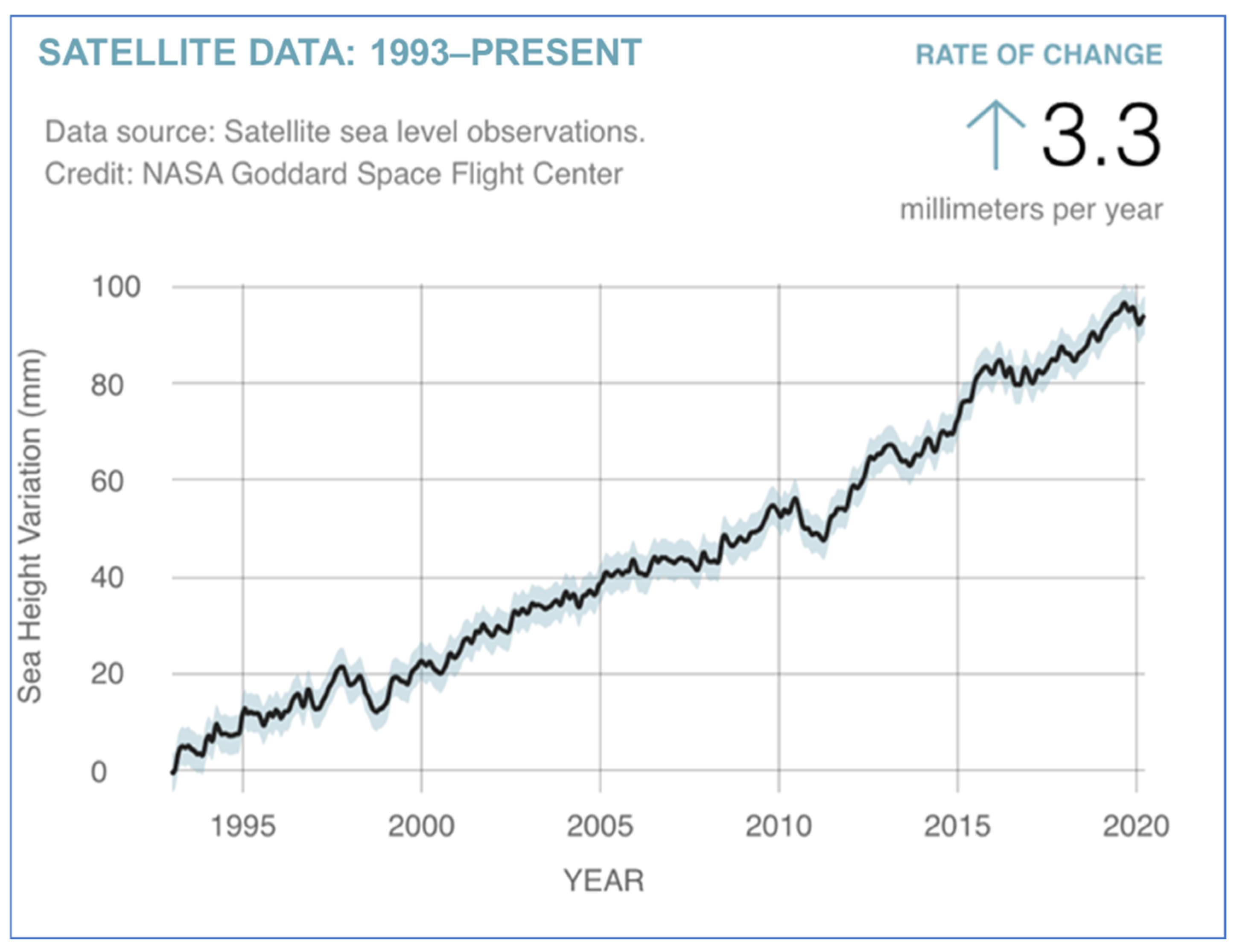
More than 30 years of observations from an international suite of satellite altimeter missions continue to provide key data enabling research discoveries and a broad spectrum of operational and user-driven applications. These missions were designed to advance technologies and to answer scientific questions about ocean circulation, ocean heat content, and the impact of climate change on these Earth systems. They are also a valuable resource for the operational needs of oceanographic and weather forecasting agencies that provide information to shipping and fishing vessels and offshore operations for route optimization and safety, as well as for other decision makers in coastal, water resources, and disaster management fields. This time series of precise measurements of ocean surface topography (OST)—the “hills and valleys” of the ocean surface—reveals changes in ocean dynamic topography, tracks sea level variations at global to regional scales, and provides key information about ocean trends reflecting climate change in our warming world. Advancing technologies in new satellite systems allows measurements at higher spatial resolution ever closer to coastlines, where the impacts of storms, waves, and sea level rise on coastal communities and infrastructure are manifest. 

satellite altimetry radar altimetry applications operational oceanography user communities

1. Introduction

For nearly 30 years, a series of satellite altimeter missions, led by the National Aeronautics and Space Administration (NASA) and its partners at the French space agency, Centre National d’Etudes Spatial (CNES), have measured ocean surface topography—the “hills and valleys” of the ocean surface influenced by gravity, ocean currents, heat content, and other dynamic geostrophic forces—to produce a continuous time series of data. Along the way, other national and international partners, including the National Oceanographic and Atmospheric Administration (NOAA), the European Space Agency (ESA), and the European Organisation for the Exploitation of Meteorological Satellites (EUMETSAT), have joined the missions. These and other partnering organizations continue to make important contributions to the missions that strengthen and enhance the science and operational returns of the significant investments made in these satellite systems. With scheduled launches through 2025, and future missions planned in the next decade, the benefit to research fields and to applications for the societal benefit of these continued missions and partnerships can be expected to grow.
Future missions in development, with advancing technologic capabilities, will extend the continuous record of consistent and calibrated data into the future. Applications for societal benefit that leverage these valuable, long-term datasets continue to expand beyond the science objectives that drove the initial development of the missions. An effort is underway by NASA and its partners to advance awareness of the utility of satellite data assets and to grow the user community. The benefits to applications from these altimetry mission data and information products include weather prediction, coastal impact (storm surges and coastal currents) assessments, fisheries management, marine transport, and disaster risk management related to sea level change and flooding (both coastal and inland), among many others. Identifying existing and potential uses of the data in operational, scientific, and other realms validates the significant resources dedicated by international space agencies to these missions. As the impacts of climate change continue to affect coastal regions around the world, the importance of satellite altimetry and its user communities can only be expected to increase.

2. From Research to Applications

Satellite missions are generally conceived of and funded with research and/or technology development objectives as a focus. They are designed to advance technologies and to address scientific questions related to ocean circulation, ocean heat potential, tides, and climate change and to advance and improve models in these and other areas. They can also be used to address operational needs of oceanographic and meteorological institutions that provide information to a wide variety of user communities, such as fishing and shipping fleets who can use it to optimize routes and operations, and for disaster management.
Global sea level rise exemplifies and is one of the more obvious and impactful consequences of climate change in the ocean. Coastal communities worldwide are already experiencing significant effects from both event-driven ocean inundation (i.e., storms at sea), as well as from high tide flooding or “sunny day” flooding where average sea levels in low-lying regions are simply more prone to flooding as sea levels continue to rise. Impacts to coastal regions from climate-driven increases in the frequency of storms and associated storm surges are exacerbated by rising sea levels and have a real cost to coastal communities [1]. Neumann et al. [2] estimated that coastal infrastructure adaptation costs for shoreline protection and nourishment along the continental U.S. coastline could reach as high as $254 billion through 2100. Community resilience planning to address these increasing threats may be improved by access to better data and models of coastal ocean dynamics, the development of which is heavily reliant on satellite remote sensing [3][4].
Before the launch of TOPEX/Poseidon, tide gauges were the only reliable mechanism for measuring trends in global sea levels. Although the tide gauge record over the last century is not definitive (due to poor spatial sampling, sensitivity to land motion and coastal effects, and other factors), some studies suggest a rate of 1.5 mm per year over this period, indicating a global average sea level rise of 15 cm (6 in) in the 20th century [5]. The satellite record (Figure 1) is now observing up to 4 mm (0.16 in) per year, resulting in nearly a 10 cm (4 in) rise since 1992 alone.
Figure 1. Global average sea level change from 1992 to 2022. The rate of rise in sea level accelerated from 2.8 mm per year in the 1990s to 4.0 mm/year in 2022 as measured by satellite altimeters. Credit: NASA.
The implications of this dramatic increase in both the absolute rise and the rate of rise in sea level on coastal communities can be significant, particularly in developing countries where the adaptive capacity is more limited [6][7]. Some factors are outlined below:
  • Increased flooding: Rising sea levels exacerbate the risk of coastal flooding, making low-lying areas more vulnerable to storm surges and high tides. This puts coastal properties, infrastructure, and human lives at greater risk [7].
  • Coastal erosion: Rising sea levels contribute to the loss of beaches, dunes, and coastal ecosystems from erosion. This can impact ecosystem health, tourism, and recreational activities, as well as the beauty and economic viability of coastal regions [8][9].
  • Infrastructure vulnerability: Critical infrastructure such as roads, bridges, ports, and other utilities in coastal regions are at higher risk from rising sea levels. These assets may require costly upgrades, relocation, or protection measures to mitigate impacts and ensure long-term functionality [6][10].
  • Displacement and relocation: More coastal and island communities will face the daunting task of relocation due to increased flooding and the loss of habitable land as sea levels rise. Displaced populations face challenges in finding alternative housing, as well as potential social and economic disruptions [10].
  • Environmental impacts: Coastal ecosystems (i.e., wetlands and estuaries) are critical habitats for numerous species and provide valuable ecosystem services. Threats from sea level rise include habitat loss, altered biodiversity, and possible cascading effects on marine and terrestrial ecosystems [11].
  • Socioeconomic consequences: Coastal communities are often centers of economic activity (tourism, fisheries, and commerce) that can be disrupted, leading to financial loss, job reduction, and decreased property value. Strain on local civic budgets can result from the need for investment in adaptation measures and disaster recovery [9][12].
Addressing these issues requires comprehensive strategies that include coastal planning, adaptation and mitigation measures, and sustainable development practices [13][14][15]. Collaboration between governments, communities, and stakeholders is crucial to effectively manage the challenges posed by accelerating sea level rise [7][16]. And, importantly, informing and educating people in these communities on the connection of these impacts to long-term climate change drivers may promote better governance and more thoughtful personal and civic choices and foster a sense of collective responsibility in addressing the underlying causes of sea level rise and climate change [17].

3. User Communities

Traditional satellite altimeter missions offer valuable information on water heights over the ocean and over large lakes, reservoirs, and rivers. The new technology and higher resolution measurements from SWOT will greatly expand the number of surface water bodies that can be viewed and monitored [18], as well as vastly improve the resolution of ocean circulation features [19]. The data can be used to assess and monitor sea level change and the coastal impacts that result but can only be truly impactful if they reach and are successfully utilized by relevant user communities. NASA and its partners recognize the importance of engaging and supporting both (1) communities of practice—those who already possess capacities for using remote sensing data and, in particular, altimetry data— and (2) communities of potential—those who could benefit from the use of satellite altimetry data but are unaware of, or lack the knowledge, technical skill, or other resources to best leverage, these observations. Investment in outreach, training, educational resources, and tools to support analysis and interpretation of these data is of utmost importance in a successful data user engagement strategy.
NASA and its partners can help to inform communities about challenges such as sea level rise, coastal flooding, and other impacts related to climate change and natural processes affecting regional coastal communities globally. One key approach is the continual measurement of water heights over the ocean and large lakes and rivers. With the launch of SWOT, monitoring of dynamic ocean topography features and an even greater number of lakes and reservoirs at significantly finer scale will be possible.
The user communities for these satellite missions include oceanographers, climatologists, coastal managers, private sector organizations, and decision makers at various levels of government. These groups can make informed decisions related to climate change adaptation and mitigation, such as identifying coastal areas at risk from sea level rise (both directly from wave action and indirectly from saltwater intrusion into coastal groundwater aquifers) and planning coastal infrastructure projects, including those designed to protect coastal communities. A key component of outreach to data users is encouraging the use of data and information products from these missions via active engagement and by supporting and training individuals and organizations in the existing and potential altimetry data user communities.
S6MF is continuing to chart the rise of sea level more precisely than previously possible, allowing researchers to understand how climate change is reshaping coastlines and the accelerating rate at which this is occurring. As more than 600 million people live in coastal areas that are lower than 10 m above sea level—a number projected to rise to one billion people by 2060 [20]—and given that many coastal regions include facilities and infrastructure critical to commerce, recreation, military installations, and transportation, understanding the impacts and trends of sea level rise will allow improved assessments of threats to vulnerable coastal regions.
Impacts from Hurricane Sandy in 2012, described as one of the most damaging hurricanes ever to make landfall in the U.S., and Hurricane Harvey in 2017, which caused $125 billion in damage (second only to Hurricane Katrina, 2005, in cost) were exacerbated by intensified storms coupled with sea level rise. Recent examples of high tide flooding along the Atlantic coast of the United States in November 2021 [21] illustrate a troubling trend that is increasingly common due to a higher relative sea level in many coastal communities. This “nuisance flooding” is expected to increase in frequency over the coming decades, according to the NOAA report “State of High Tide Flooding and Annual Outlook” [22]. For U.S. coastal communities, high tide flooding events are likely to reach 7–15 days by 2030 and 25–27 days by 2050 [23].
The data collected from satellite altimeter missions have tremendous potential to inform decision making and improve the quality of life for people around the world. Measuring water surface topography over the globe enables a wide range of practical applications with tangible benefits to society. These include planning for the impacts of sea level rise on coastal communities as discussed above, supporting operational oceanography and safety at sea, improved flood modeling, transboundary water information sharing, weather and climate forecasting, water resources management, and decision support, among others.
In 2014, a U.S. presidential executive order established the National Plan for Civil Earth Observations (the National Plan) to promote the use of observing system data and information products in 12 identified societal benefit areas [24]. Altimetry data may be useful in informing at least half of these. The use of altimetry data contributes to the following societal benefit areas of the National Plan:
  • Biodiversity—understanding and conservation of biodiversity, fisheries management, and marine protected areas.
  • Climate—understanding and assessment of sea level rise and global ocean heat content using climate records from altimetry.
  • Disasters (hazards)—storm surge from coastal storms, hurricane intensity forecasts, and improved tsunami wave models.
  • Ocean and coastal resources—storm surge modeling, sediment transport, and water quality.
  • Water resources—climate-related impacts to the Earth’s water cycle and resources.
  • Weather—seasonal forecasts of the numbers and strengths of hurricanes expected in a given hurricane season, as well as intensity forecasts of individual hurricanes.

References

  1. Padgett, J.E.; Panakkal, P.; González-Dueñas, C. Infrastructure impacts and vulnerability to coastal flood events. In Coastal Flood Risk Reduction; Brody, S., Lee, Y., Kothuis, B.B., Eds.; Elsevier Press: Amsterdam, The Netherlands, 2022; pp. 151–165.
  2. Neumann, J.; Hudgens, D.; Herter, J.; Martinich, J. The Economics of Adaptation along Developed Coastlines. Wiley Interdiscip. Rev. Clim. Chang. 2011, 2, 89–98.
  3. Vitousek, S.; Buscombe, D.; Vos, K.; Barnard, P.; Ritchie, A.; Warrick, J. The future of coastal monitoring through satellite remote sensing. Camb. Prism. Coast. Futures 2023, 1, E10.
  4. Ouellette, W.; Getinet, W. Remote sensing for Marine Spatial Planning and Integrated Coastal Areas Management: Achievements, challenges, opportunities and future prospects. Remote Sens. Appl. Soc. Environ. 2016, 4, 138–157.
  5. Nerem, R.S.; Fasullo, J. Observations of the Rate and Acceleration of Global Mean Sea Level Change. Bull. Amer. Meteor. Soc. 2019, 100, S15–S18.
  6. Appeaning Addo, K.; Larbi, L.; Amisigo, B.; Kwabena Ofori-Danson, P. Impacts of Coastal Inundation Due to Climate Change in a Cluster of Urban Coastal Communities in Ghana, West Africa. Remote Sens. 2011, 3, 2029–2050.
  7. Johnson, E.; Bell, J.; Coker, D.; Hertz, E.; Labarge, N.; Blake, G. A lifeline and social vulnerability analysis of sea level rise impacts on rural coastal communities. Shore Beach 2018, 86, 36–44.
  8. Periasamy, A. Effects of coastal erosion due to climate change on fishermen communities in Tamil Nadu. Disaster Adv. 2023, 16, 68–74.
  9. Scyphers, S.; Beck, M.; Furman, K.; Haner, J.; Josephs, L.; Lynskey, R.; Keeler, A.; Landry, C.; Powers, S.; Webb, B.; et al. A Waterfront View of Coastal Hazards: Contextualizing Relationships among Geographic Exposure, Shoreline Type, and Hazard Concerns among Coastal Residents. Sustainability 2019, 11, 6687.
  10. Gomaa, M.M. Assessing the Impacts of Population Relocation Induced by Future Sea-Level Rise Scenarios on Transportation Systems in Coastal Communities. Sustain. Urban Plan. Divid. Cities 2022, 7, 68–83.
  11. Ward, R.D.; Burnside, N.G.; Joyce, C.B.; Sepp, K.; Teasdale, P.A. Improved modelling of the impacts of sea level rise on coastal wetland plant communities. Hydrobiologia 2016, 774, 203–216.
  12. Makame, M.O.; Mwevura, H. Vulnerability and Adaptation Strategies of Coastal Communities to the Associated Impacts of Sea Level Rise and Coastal Flooding. In Climate Change and Coastal Resources in Tanzania; Yanda, P., Bryceson, I., Mwevura, H., Mung’ong’o, C., Eds.; Springer Climate: Cham, Switzerland, 2019.
  13. D’Alessandro, F.; Tomasicchio, G.; Francone, A.; Leone, E.; Frega, F.; Chiaia, G.; Saponieri, A.; Damiani, L. Coastal sand dune restoration with an eco-friendly technique. Aquat. Ecosyst. Health Manag. 2020, 23, 417.
  14. Guthrie, A.; Stafford, S.; Scheld, A.M.; Nunez, K.; Bilkovic, D.M. Property owner shoreline modification decisions vary based on their perceptions of shoreline change and interests in ecological benefits. Front. Mar. Sci. 2023, 10, 1031012.
  15. Sauvé, P.; Bernatchez, P.; Moisset, S.; Glaus, M.; Goudreault, M.-O. A need to better monitor the effects of coastal defense measures on coastal socio-ecological systems to improve future adaptation solutions. Ocean Coast. Manag. 2023, 239, 106599.
  16. Smith, E.A.; Sweet, W.; Mitchell, M.; Domingues, R.; Weaver, C.P.; Baringer, M.; Goni, G.; Haines, J.; Loftis, J.D.; Boon, J.; et al. Treading Water: Tools to Help US Coastal Communities Plan for Sea Level Rise Impacts. Front. Mar. Sci. 2019, 6, 300.
  17. Vázquez, L.; Vandergeest, P. Coastal erosion narratives in the Gulf of Mexico: Implications for climate change governance. J. Political Ecol. 2022, 29, 705–724.
  18. Altenau, E.H.; Pavelsky, T.M.; Durand, M.T.; Yang, X.; Frasson, R.P.d.M.; Bendezu, L. The surface water and ocean topography (SWOT) mission river database (SWORD): A global river network for satellite data products. Water Resour. Res. 2021, 57, e2021WR030054.
  19. Cazenave, A. Satellite Altimetry. In Encyclopedia of Ocean Sciences, 3rd ed.; Cochran, J.K., Bokuniewicz, H.J., Yager, P.L., Eds.; Academic Press: San Diego, CA, USA, 2019; pp. 397–401.
  20. Neumann, B.; Vafeidis, A.T.; Zimmermann, J.; Nicholls, R.J. Future Coastal Population Growth and Exposure to Sea-Level Rise and Coastal Flooding—A Global Assessment. PLoS ONE 2015, 10, e0118571.
  21. US Department of Commerce (USDC) 2021. November 6–8, 2021 Coastal Flooding. National Weather Service, 22 December 2021. Available online: https://www.weather.gov/ilm/Nov2021CoastalFlood(accessed on 3 August 2023).
  22. Sweet, W.; Simon, S.; Dusek, G.; Marcy, D.; Brooks, W.; Pendleton, M.; Marra, J. The State of High Tide Flooding and Annual Outlook, NOAA Tides & Currents. Retrieved November 30, 2021. Available online: https://tidesandcurrents.noaa.gov/publications/2021_State_of_High_Tide_Flooding_and_Annual_Outlook_Final.pdf(accessed on 3 August 2023).
  23. US Harbors. The State of High Tide Flooding and Annual NOAA Outlook. 2022. USHarbors.com. Available online: https://www.usharbors.com/2022/05/the-state-of-high-tide-flooding-and-annual-noaa-outlook/ (accessed on 3 August 2023).
  24. National Science and Technology Council. National Plan for Civil Earth Observations. 2014. Available online: https://obamawhitehouse.archives.gov/sites/default/files/microsites/ostp/NSTC/2014_national_plan_for_civil_earth_observations.pdf (accessed on 3 August 2023).
More
Information
Contributors MDPI registered users' name will be linked to their SciProfiles pages. To register with us, please refer to https://encyclopedia.pub/register : ,
View Times: 209
Revisions: 2 times (View History)
Update Date: 24 Aug 2023
1000/1000
Video Production Service