Your browser does not fully support modern features. Please upgrade for a smoother experience.
Submitted Successfully!
 +1 credit
Thank you for your contribution! You can also upload a video entry or images related to this topic.
For video creation, please contact our Academic Video Service.
| Version | Summary | Created by | Modification | Content Size | Created at | Operation |
|---|---|---|---|---|---|---|
| 1 | Minhaz Farid Ahmed | -- | 1131 | 2023-07-13 10:34:58 | | | |
| 2 | Conner Chen | Meta information modification | 1131 | 2023-07-17 04:23:33 | | |
Video Upload Options
We provide professional Academic Video Service to translate complex research into visually appealing presentations. Would you like to try it?
Cite
If you have any further questions, please contact Encyclopedia Editorial Office.
Ahmed, M.F.; Mokhtar, M.B.; Lim, C.K.; Suza, I.A.B.C.; Ayob, K.A.K.; Khirotdin, R.P.K.; Majid, N.A. Significance of the Langat River Basin, Malaysia. Encyclopedia. Available online: https://encyclopedia.pub/entry/46740 (accessed on 28 July 2026).
Ahmed MF, Mokhtar MB, Lim CK, Suza IABC, Ayob KAK, Khirotdin RPK, et al. Significance of the Langat River Basin, Malaysia. Encyclopedia. Available at: https://encyclopedia.pub/entry/46740. Accessed July 28, 2026.
Ahmed, Minhaz Farid, Mazlin Bin Mokhtar, Chen Kim Lim, Izzati Afiqah Binti Che Suza, Ku Adriani Ku Ayob, Rd. Puteri Khairani Khirotdin, Nuriah Abd Majid. "Significance of the Langat River Basin, Malaysia" Encyclopedia, https://encyclopedia.pub/entry/46740 (accessed July 28, 2026).
Ahmed, M.F., Mokhtar, M.B., Lim, C.K., Suza, I.A.B.C., Ayob, K.A.K., Khirotdin, R.P.K., & Majid, N.A. (2023, July 13). Significance of the Langat River Basin, Malaysia. In Encyclopedia. https://encyclopedia.pub/entry/46740
Ahmed, Minhaz Farid, et al. "Significance of the Langat River Basin, Malaysia." Encyclopedia. Web. 13 July, 2023.
Copy Citation
Approximately 2986 river basins can be found in Malaysia, but only 189 of them are viewed as significant basins dependent on the region of the basin that is >80 km2. IRBM has many cross-cutting concerns, thus accomplishing a sound IRBM will connect practically all the Sustainable Development Goals (SDGs). Langat is the UNESCO HELP (Hydrology for the Environment, Life, and Policy) River Basin in Malaysia, and distinct in its attributes because of its flow through three distinct constituencies. Langat River Basin is among the HELP basins from the 91 river basins globally, 26 river basins in the Asia Pacific region, and 3 from the south-east Asia region.
leadership roles
local authority
river basin
1. Jurisdiction of Langat River Basin
The Langat river basin ranges around 1815 km2, and the river’s major course is 141 km, located about 40 km east of Kuala Lumpur. It is geographically located from 02°40′152″ N latitude to 3°16′15″ N and 101°19′20″ E to 102°1′10″ E longitude with the most elevated peak at 820.8 m (2691 ft) [1]. Strikingly, about 75% of the catchment area is located on an uneven landscape with a normal slant of 6–9″ and another 25% of the region is under 6″ with a few swamps by the river [2]. The significant tributaries of the Langat River are the Semenyih, Beranang, and Labu rivers; nevertheless, around 40 smaller tributaries are flowing into Langat [3]. A few development projects are being carried out in the transboundary Langat River Basin, which shares the Selangor State (78.14%), Negeri Sembilan State (19.64%), and the Federal Territories of Kuala Lumpur (0.33%) and Putrajaya (1.90%) (Table 1).
Table 1. Percentage area of Langat River Basin among the district councils and states.
| State | City/District Council | 1 Area of Langat Basin (%) | 2 Population | 2 Household |
|---|---|---|---|---|
| Selangor | Majlis Perbandaran Klang | 35.39 | 842,146 | 201,994 |
| Majlis Perbandaran Kuala Langat | 26.27 | 220,214 | 49,798 | |
| Majlis Daerah Hulu Langat | 3.39 | 1,138,198 | 288,508 | |
| Majlis Perbandaran Sepang | 13.09 | 207,354 | 49,005 | |
| Negeri Sembilan | Majlis Perbandaran Nilai | 19.64 | 200,988 | 48,430 |
| Federal Territory of Putrajaya | Perbandaran Putrajaya | 1.90 | 68,361 | 19,511 |
| Federal Territory of Kuala Lumpur | Dewan Bandaraya Kuala Lumpur | 0.33 | 1,588,750 | 419,187 |
| Total | 100 | 4,266,011 | 1,076,433 | |
The Langat River Basin holds a population of 1,184,917 in the year 2000 with a rate of growth of 7.64% [2]. In 2013, the population grew to 4,266,011 based on the report by the Department of Statistics Malaysia [5]. Langat River is among the basin’s primary drinking water sources, it provides drinking water to an incredibly significant number of people in Selangor state including VVIPs residing in Putrajaya, the central federal government city of Malaysia, which also holds the Prime Ministers’ Office. Langat River Basin is among the quickest-growing regions in the nation, where a few huge socio-economic development projects have taken place or are in the process of completion [2]. Additionally, the raw water of Langat is utilized for industrial, horticultural, and transportation activities.
2. Changes in Land Use Pattern in Langat River Basin
Incidentally, the land use trend has had a major transformation in the Langat River Basin because of rapid development. The development areas around the basin expanded by 23.5% in 2013 contrasted with 2.4% in 1974 (Table 2). Thus, both the farming and forestry areas have reduced in 2013 in comparison to 1974, while the peat swamp and mangrove regions have radically diminished to 9.4% in 2013 compared to 25.7% in 1974. As such, the accessibility to water in the Langat area has been hampered including the loss of biodiversity. Moreover, the fast growth has additionally expanded the chemical and biological contamination of the river which requires treatment prior to drinking.
Table 2. Land use changes of the Langat River Basin, Malaysia during 1974 to 2013.
| Land Use Type | 1974 (ha) | % | 1991 (ha) | % | 2001 (ha) | % | 2013 (ha) | % |
|---|---|---|---|---|---|---|---|---|
| Forest | 52,579.7 | 17.9 | 50,906.4 | 17.3 | 45,071.9 | 15.4 | 48,285 | 16.5 |
| Mangroves and Peat swamp | 75,252.6 | 25.7 | 37,014.5 | 12.6 | 25,630.7 | 8.7 | 27,560.8 | 9.4 |
| Agriculture | 155,249 | 52.9 | 170,705 | 58.2 | 164,841 | 56.2 | 142,387.9 | 48.5 |
| Developed Area | 7022.8 | 2.4 | 28,510.7 | 9.7 | 51,502.8 | 17.5 | 69,056.1 | 23.5 |
| Water body | 3267.3 | 1.1 | 6401.5 | 2.2 | 6207.1 | 2.1 | 6009.1 | 2 |
| Total | 293,370.3 | 100 | 293,340.5 | 100 | 293,253.6 | 100 | 293,298.9 | 100 |
Note(s): Source: [2].
3. Sources of Pollution at Langat River Basin
LUAS [4] has pinpointed the areas of point sources in the Langat River Basin, Malaysia (Figure 1). There are a few industrial areas around the basin in the Nilai industrial area in the state of Negeri Sembilan. Subsequently, the release of illegal effluents in the area is a genuine contamination threat to the river based on the inadequate execution of the Environmental Quality Act 1974 and its revision with the Environmental Quality (Industrial Effluent) Regulations 2009 [6].
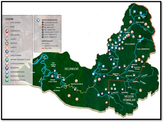
Figure 1. Location of point sources of pollution in the Langat River Basin, Malaysia [4].
The DOE in 2013 detailed that the food industry at 79% is the principal polluter of the Langat River with sewage releases contributing a further 10.8%. Even though industrial waste release decreased to 9.09% in the Langat River in 2013 contrasted with 84.09% in 2002 [1], it still remains a crucial source of chemical contamination in the river in addition to the contamination from the food industry sector. In spite of the fact that sand mining/quarry is liable for just 0.24% contamination in the Langat River [7], there are 86 sand and gravel extraction locations in the Langat Basin out of 198 extraction locations throughout the Selangor state (81 locations) and Negeri Sembilan state (5 locations). Additionally, 43 earth material extraction locations, 21 granite quarries, 2 clay pits, as well as 1 kaolin pit operational site were found in the Langat River Basin [8]. In the meantime, Aris et al. [9] revealed that the mining operations fundamentally increased the predominance of Cu, Sn, Fe, Au, etc. in the surface water of Langat River.
4. Impact of Climate Change in Langat River Basin
The contamination of Malaysian rivers based on climatic and anthropogenic issues is a major concern. Numerous studies have already detailed flood occurrence due to heavy rainfall in Malaysia [10][11][12] and the situation is worsened due to landslides into the riverbank, lack of proper drainage systems, and elevated spring tides [11][13]. Thus, flood is now the most crucial natural disaster as a result of its recurrence and degree in the 189 river basins in Peninsular Malaysia, Sabah, and Sarawak [12]. Flooding has a serious effect on 9% of land in the nation (29,720 km2) and on 21% of the population (4.915 million) that costs the country about 915 million MYR annually with the extra financial consequential cost of 1.83 billion MYR [12]. Moreover, the frequency and intensity of the recurrence of floods have expanded fundamentally in Malaysia in light of climate change rainfall trends [14].
The quantity of flood occurrences in the Langat River basin has grown from 2006 to 2016. The highest number of floods was recorded at 85 incidents at the river basin in 2015; it was only 36 flood occurrences in 2005 [15]. In addition, 20 dangerous hill slopes have been noted in Selangor, which is in danger of landslides if nothing is carried out to maintain the slopes properly [16]. The Selangor state and Federal Territories Minerals and Geoscience Department reported approximately 1000 hill slopes with potential risk in the Klang Valley [16]. Essentially, the high tides from 21 September to 5 December 2017 at the Langat River Basin were also cause for concern which could result in severe flooding. Residential areas in Selangor, for example, Klang, Kuala Langat, Sepang, Kuala Selangor, and Sabak Bernam were expected to be in danger of flooding with tides as high as 5.5 m to 5.6 m [17]. Additionally, a few landslides were reported from 1999 to 2011 in the Langat River Basin due to the sliding/streaming of soil debris from the hills during overwhelming rainfalls, deforestation, the collapse of river banks, and retrogressive slope downfalls [6], further contributing to the contamination of the Langat River.
References
- Juahir, H.; Zain, S.M.; Yusoff, M.K.; Hanidza, T.T.; Armi, A.M.; Toriman, M.E.; Mokhtar, M. Spatial water quality assessment of Langat River Basin (Malaysia) using environmetric techniques. Environ. Monit. Assess. 2011, 173, 625–641.
- Elfithri, R. Establishment of Sustainability Science Demonstration Pilot Project on Restoring and Managing Langat River, Malaysia for Future; Institute for Environment and Development: Bangi, Malaysia, 2016; Available online: http://jfit-for-science.asia/wp-content/uploads/502_Sustainability-Science-Pilot-Project-Langat-River-Malaysia.pdf (accessed on 24 September 2017).
- LUAS. Sungai Langat, State of the River Report 2015; Lembaga Urus Air Selangor (LUAS): Shah Alam, Malaysia, 2015; ISBN 2180-2793.
- DOE. Study on Pollution Prevention and Water Quality Improvement Program of Sungai Langat; Shaaban, M.G., Alwan, H.K., Jaafar, M.N., Abdullah, A.R., Ismail, M.Z., Idris, A., Hamidon, A.B., Sharom, A., Zakri, I.M., Othman, P.F., et al., Eds.; Department of Environment (DOE): Kuala Lumpur, Malaysia, 2003.
- DOS. Population Distribution by Local Authority Areas and Mukims 2010; Department of Statistics (DOS): Putrajaya, Malaysia, 2013. Available online: http://newss.statistics.gov.my/newss-portalx/ep/epProductFreeDownloadSearch.seam (accessed on 10 November 2017).
- Ahmed, M.F.; Alam, L.; Ta, G.C.; Mohamed, C.A.R.; Mokhtar, M. A review on the chemical pollution of Langat River, Malaysia. Asian J. Water Environ. Pollut. 2016, 13, 9–15.
- DOE. Malaysia Environmental Quality Report 2013; Department of Environment (DOE): Putrajaya, Malaysia, 2013.
- Juahir, H. Water Quality Data Analysis and Modeling of the Langat River Basin. Ph.D. Thesis, University of Malaya, Kuala Lumpur, Malaysia, 2009. Available online: http://repository.um.edu.my/1223/5/Chapter%203%20Revised.pdf (accessed on 20 June 2017).
- Aris, A.Z.; Lim, W.Y.; Looi, L.J. Natural and Anthropogenic Determinants of Freshwater Ecosystem Deterioration: An Environmental Forensic Study of the Langat River Basin, Malaysia. In Environmental Management of River Basin Ecosystems; Ramkumar, M., Ed.; Springer Earth System Sciences: Cham, Switzerland, 2015; pp. 455–476.
- Ching, Y.C.; Yatim, B.; Toriman, M.E.; Lee, Y.H.; Surif, S.; Abdullah, M. Impact of Climate Change on Flood Risk in the Muar River Basin of Malaysia. Disaster Adv. 2013, 6, 11–17.
- DID. Flood Management (Vol. 1); Department of Irrigation and Drainage (DID): Kuala Lumpur, Malaysia, 2009.
- Hussaini, H.A. Flood and Drought Management in Malaysia; Ministry of Natural Resources and Environment: Kuala Lumpur, Malaysia, 2007.
- Tam, T.; Ibrahim, A.; Rahman, M.; Mazura, Z. Flood Loss Assessment in the Kota Tinggi. In Proceedings of the IOP Conference Series: Earth and Environmental Science, Kuching, Malaysia, 26–29 August 2013.
- IPCC. Climate Change 2014: Impacts, Adaptation, and Vulnerability. Part B: Regional Aspects. Contribution of Working Group II to the Fifth Assessment Report of the Intergovernmental Panel on Climate Change; Barros, V.R., Field, C.B., Dokken, D.J., Mastrandrea, M.D., Mach, K.J., Bilir, T.E., Chatterjee, M., Ebi, K.L., Estrada, Y.O., Genova, R.C., et al., Eds.; Cambridge University Press: Cambridge, UK; New York, NY, USA, 2014.
- Ahmed, M.F. Risk Based Assessment and Management of Drinking Water in Langat River Basin, Malaysia. Ph.D. Thesis, Universiti Kebangsaan Malaysia (UKM), Bangi, Malaysia, 2019.
- Arumugam, T. 20 Slopes in Selangor Identified at Critical Risk of Landslide. New Straits Times. 2017. Available online: https://www.nst.com.my/news/nation/2017/09/282057/20-slopes-selangor-identified-critical-risk-landslide (accessed on 24 September 2017).
- Muthiah, W. Selangor Told to Prepare for Big Waves Due to High Tides over Next Three Months. New Straits Times. 2017. Available online: http://www.thestar.com.my/news/nation/2017/09/20/selangor-told-to-prepare-for-tidal-waves-over-next-three-months/ (accessed on 24 September 2017).
More
Information
Subjects:
Water Resources
Contributors
MDPI registered users' name will be linked to their SciProfiles pages. To register with us, please refer to https://encyclopedia.pub/register
:
View Times:
2.8K
Revisions:
2 times
(View History)
Update Date:
17 Jul 2023
Table of Contents


Notice
You are not a member of the advisory board for this topic. If you want to update advisory board member profile, please contact office@encyclopedia.pub.
OK
Confirm
Only members of the Encyclopedia advisory board for this topic are allowed to note entries. Would you like to become an advisory board member of the Encyclopedia?
Yes
No
${ textCharacter }/${ maxCharacter }
Submit
Cancel
Back
Comments
${ item }
|
${ item.createdUser.fullName }
${ item.createdAt }
${ item.vote }
${ item.reply }
Delete
${ reply.createdUser.fullName }
${ reply.createdAt }
${ reply.vote }
Delete
There is no reply to this comment~
${ item.replyTextCharacter }/${ item.replyMaxCharacter }
Submit
Cancel
More
No more~
There is no comment~
${ textCharacter }/${ maxCharacter }
Submit
Cancel
${ selectedItem.replyTextCharacter }/${ selectedItem.replyMaxCharacter }
Submit
Cancel
Confirm
Are you sure to Delete?
Yes
No