Your browser does not fully support modern features. Please upgrade for a smoother experience.
Submitted Successfully!
 +1 credit
Thank you for your contribution! You can also upload a video entry or images related to this topic.
For video creation, please contact our Academic Video Service.
| Version | Summary | Created by | Modification | Content Size | Created at | Operation |
|---|---|---|---|---|---|---|
| 1 | Muhammad Awais Hussain | -- | 4080 | 2023-02-07 15:05:03 | | | |
| 2 | Rita Xu | Meta information modification | 4080 | 2023-02-08 03:25:00 | | |
Video Upload Options
We provide professional Academic Video Service to translate complex research into visually appealing presentations. Would you like to try it?
Cite
If you have any further questions, please contact Encyclopedia Editorial Office.
Hussain, M.A.; Shuai, Z.; Moawwez, M.A.; Umar, T.; Iqbal, M.R.; Kamran, M.; Muneer, M. Natural Hazards in Pakistan. Encyclopedia. Available online: https://encyclopedia.pub/entry/40933 (accessed on 11 July 2026).
Hussain MA, Shuai Z, Moawwez MA, Umar T, Iqbal MR, Kamran M, et al. Natural Hazards in Pakistan. Encyclopedia. Available at: https://encyclopedia.pub/entry/40933. Accessed July 11, 2026.
Hussain, Muhammad Awais, Zhang Shuai, Muhammad Aamir Moawwez, Tariq Umar, Muhammad Rashid Iqbal, Muhammad Kamran, Muhammad Muneer. "Natural Hazards in Pakistan" Encyclopedia, https://encyclopedia.pub/entry/40933 (accessed July 11, 2026).
Hussain, M.A., Shuai, Z., Moawwez, M.A., Umar, T., Iqbal, M.R., Kamran, M., & Muneer, M. (2023, February 07). Natural Hazards in Pakistan. In Encyclopedia. https://encyclopedia.pub/entry/40933
Hussain, Muhammad Awais, et al. "Natural Hazards in Pakistan." Encyclopedia. Web. 07 February, 2023.
Copy Citation
Natural hazards are dynamic and unpredictable events that are a continuous threat to global socio-economic development. Humans’ reactions to these catastrophes are influenced by their proximity to the hazards and their ability to anticipate, resist, cope with, and recover from their consequences. Due to climatic changes, the risk of multiple natural hazards is expected to increase in several regions of Pakistan.
natural hazards
spatial variations
climate change
1. Introduction
Climate change and increasingly extreme weather events have caused a surge in natural hazards in Pakistan. Major hazards such as inland floods, storms, earthquakes, landslides, droughts, cyclones, and tsunamis [1] cause harm to people and a country’s economy. The effect of disasters differs significantly from country to country and is primarily determined by a community’s physical and socio-economic strength. The economic losses caused by extreme events have been reported to be higher in developed countries [2][3] than in developing countries, but the opposite is true for human casualty figures. In recent years, Pakistan is facing a substantial rise in the frequency and severity of weather events and earthquakes. This has a detrimental effect on underprivileged communities, including the men and women living in them. According to the German Watch Report 2019 [4], Pakistan is constantly affected by catastrophes. It ranks among the most affected countries due to natural hazards concerning human deaths, with around 512 fatalities annually between 1998 and 2020 [5]. On 4 January 2010, a massive mound of rocks crashed down the hill at Attabad, a town in Gilgit-Baltistan, north Pakistan [6]. The massive landslide buried parts of the town and the adjacent village of Sarat in the confined strip of land of the Hunza River. This landslide event did not appear suddenly [7]. The slope had been showing signs of developing fissures for years. While this was bad enough, it caused a second calamity due to the first. The debris produced a huge obstacle of a hundred meters high and one kilometer wide, blocking the Hunza River’s passage [8] and covering up the Karakorum Highway (KKH). As a result, the entire territory upstream, the Gojal Tahsil, was isolated from Pakistan. Following that, a lake formed behind the obstacle, which kept expanding until August 2010. It had grown to about thirty kilometers long at that point [9]. One town was entirely flooded, while four others were partially flooded. Large portions of the KKH were flooded, causing major communication difficulties between the towns. Furthermore, hazards that originate outside of Pakistan’s borders can affect Pakistan’s society and economy. There is a need to develop new institutional frameworks [10][11][12] with the mission of developing multi-disaster risk management strategies. For better risk assessment and management planning, an integrated approach should be adopted by the researchers and scientific community, as set forth in multi-hazard early warning systems for disaster risk reduction reported by the World Meteorological Organization (WMO) [13]. Natural disasters, such as earthquakes and landslides, may strike without warning [14][15]. Droughts or famines are examples of slow-moving events [16]. A series of major disasters have hit Pakistan in recent years [17]. There is a pressing need for an increased understanding of spatial discrepancies in natural hazards due to climate change within a country and mapping regions that require resources to increase resilience and achieve adaptation and sustainable development goals.
2. Spatial Variations of Natural Hazards in Pakistan
Pakistan is exposed to a wide range of natural and manmade hazards. The wide range of natural hazards that Pakistan faces is due to the geological, topographic, and meteorological diversity of the country [18][19][20]. Natural disasters may occur on a variety of geographical and temporal dimensions. These occurrences vary greatly, ranging from a few seconds to several months [10]. Landslides, avalanches, and earthquake impacts are short occurrences that last only seconds to minutes. Other occurrences continue longer, ranging from a few hours to many days, such as heavy rain, flash floods, winter storms, debris flow, and earthquake. Cold and heat waves are long-term occurrences that can last anywhere from a few days to a few months [21]. The Indus Plain, which runs from north to south through Pakistan, covers more than 60% of the nation. The provinces of Baluchistan and Khyber Pakhtunkhwa are mountainous. Baluchistan is categorized as a semi-desert environment, with irrigated rice and wheat crops only present in the Indus Valley and lowlands and some northern woods. Pakistan is made up of high-contrast regions with drastic temperature differences across seasons and locations
2.1. Floods
Pakistan is one of the top ten nations globally for frequent and severe global climate events such as floods, cyclones, heavy rains, excessive heat, etc. Pakistan is one of South Asia’s most flood-prone countries. Pakistan is among the five South Asian countries with the most significant yearly average number of flood-affected individuals. For many years, the average world temperature has risen due to rise in atmospheric carbon dioxide and other greenhouse gas concentrations [22][23]. It has increased by 0.6 degrees Celsius during the previous century and is expected to rise by another 1.0 to 4.0 degrees Celsius through the end of the present century. Floods in several regions of Pakistan during the rainy season are the most recent severe climatic occurrences to affect Pakistan [24]. Since 2010, Pakistan has witnessed flooding virtually every year, resulting in massive losses of life and property. Climate change is also threatening the country’s water security. Increasing temperatures in the country’s mountainous ranges were expected to cause glacier melting, impacting the Indus River system’s flows [25]. Floods occur virtually every year, destroying large areas of land and standing crops and affecting and displacing millions of people. It has been the country’s most common natural danger since its founding in 1947. Flooding has become more common over the last few years as a result of global warming and fast climate change. Pakistan has seen several catastrophic flood disasters since its inception. The severity of flood hazards at the district level in Pakistan between 1970 and 2020 is shown in Figure 1. Figure 1 shows that southern part of Sindh and Punjab and some districts of KPK and Kashmir are very highly affected by the floods. This map was made on the basis of the occurrences of flood events in the past 50 years from 1970–2020. In addition, the districts of Washuk and Kharan of Baluchistan, most of districts Gilgit Biltistan, and some districts of Punjab, Sindh are found to be highly affected to floods, and most of the districts of Baluchistan and Punjab and some of the districts of KPK and Sindh were less affected by the floods.
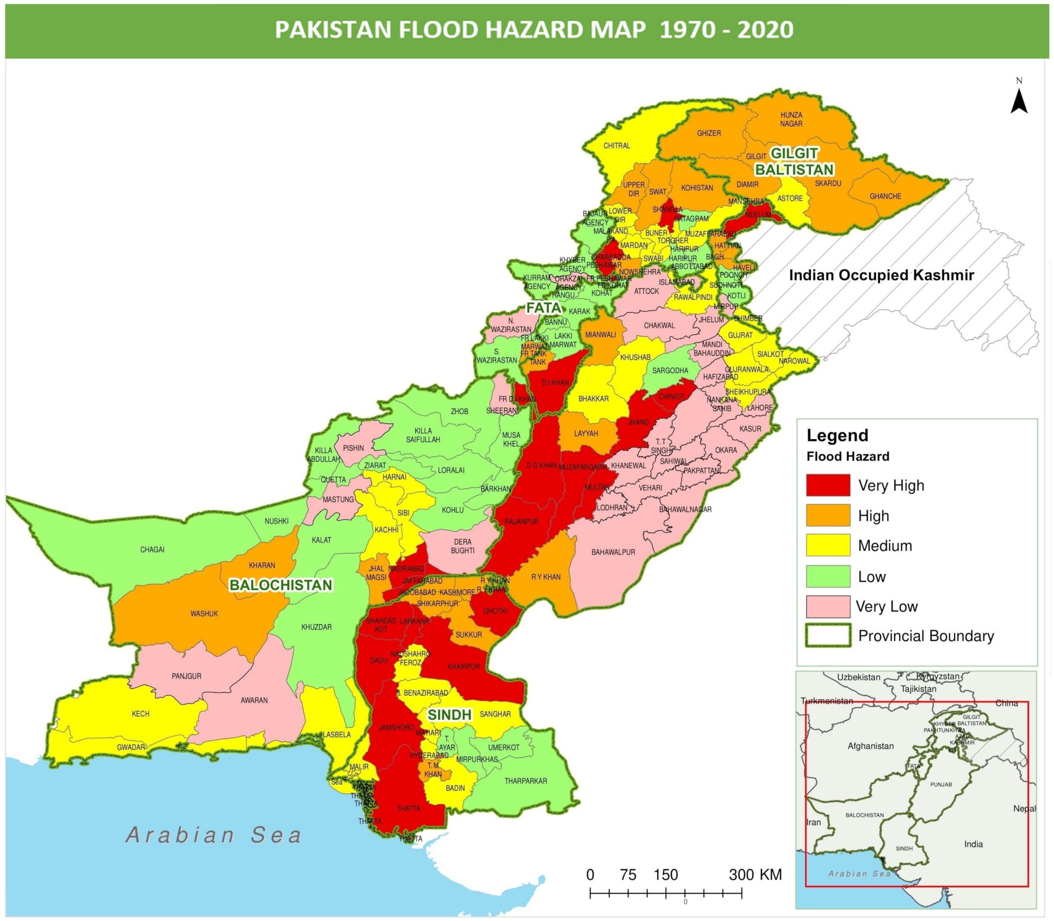
Figure 1. Pakistan Flood Hazard Map 1970–2020 showing intensity of flood at district level.
Riverine floods in the Indus River Basin, storm floods, glacial lake outburst floods (GLOFs) [26][27], and flash flooding linked with cyclone activity are the four primary types of floods that affect Pakistan regularly. Floods caused by rivers primarily occur in the Indus River Basin and inundate floodplains along major rivers (Indus, Jhelum, Chenab, Ravi, Sutlej, and Kabul). Such riverine floods are particularly severe in Punjab and Sindh Provinces, where they have recently inflicted exceptionally significant damages almost yearly. Agriculture is particularly affected in this area by damage to standing kharif crops. However, in certain situations, the flooded areas do not dry out in time, causing rabi crops planting to be hampered. Water spills do not return to the main river channel in the lower Indus River (Sindh province), which runs at a higher elevation than the neighboring plains. The 2010 floods, for example, were enormous, impacting virtually all of Pakistan. The damage was estimated to be worth USD 9.7 billion, as shown in Figure 2. Agriculture and cattle were severely affected, and the water also destroyed many homes and damaged roads and irrigation systems. According to Pakistani officials, more than 1700 people died as a result of this flooding, and more than 20 million people were affected [28][29][30]. The number of people displaced by the flooding outnumbered those displaced by the 2004 Indian Ocean tsunami, the 2005 Kashmir earthquake, and the 2010 Haiti earthquake combined. In Sindh Province alone, the 2011 floods impacted another 8.9 million people and damaged 1.5 million houses in 37,000 communities [31]. Flash floods are caused by highly localized connective rainfall or cloudbursts that occur in small- to medium-sized basins in hilly terrains and at the foot of mountains and hills. Such occurrences, which are common in Baluchistan, Khyber Pakhtunkhwa, and the northern provinces, can cause significant damage to crops and animals and substantially influence urban centers. The Nullah Lai, for example, overflowed and swamped surrounding buildings, bridges, and highways in July 2001 as a result of prolonged severe rains. According to government estimates, at least 10 individuals were killed, 800 homes were demolished, and 1069 homes were damaged in Islamabad. Twenty-six people died, and hundreds of houses were destroyed in Karachi in 2009. The overall damages attributable to significant flood occurrences in Pakistan total to more than USD 38.171 billion [32] during the last 67 years (1953 to 2020), with 50 percent of total direct losses occurring in the last decade after 2010. Figure 2 shows the districts that were affected by 2010 floods. Three provinces, namely Punjab, Sindh, and KPK, were severely affected by this flood. About 84 districts out 154 districts of Pakistan were affected due to this flood. Most of the districts around the River Sindh were severely affected by this flood.
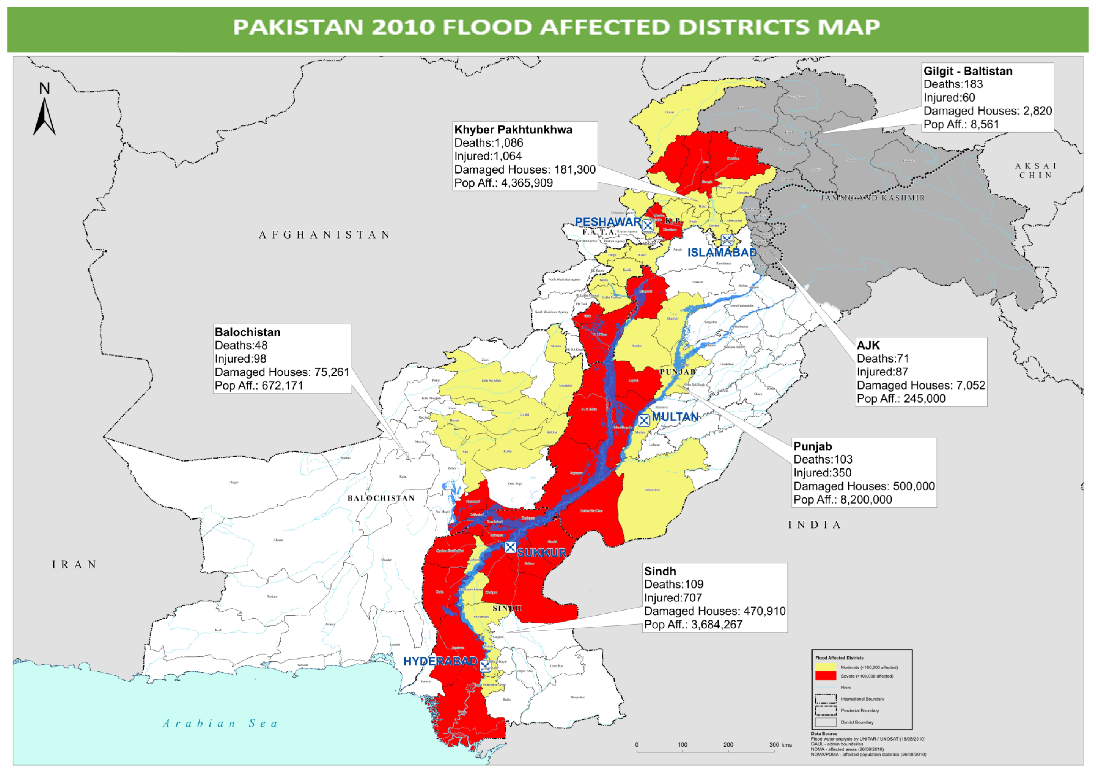
Figure 2. Map showing number of deaths, injuries, damaged homes, and affected population by province and region as of 30 August 2010. Source: 2010 Flood water analysis by OCHA [33].
2.2. Drought
Drought is one of the probable repercussions of global warming, resulting in a significant drop in water table levels and the drying up of wetlands. Pakistan is one of the nations predicted to be impacted the worst by global warming [34][35]. Drought has wreaked havoc on districts across Pakistan’s southern and eastern regions. With low rainfall and severe temperature fluctuations, 60% of the country is categorized as semi-arid to dry, most notably in Baluchistan, Sindh, and the southern portion of Punjab. Arid areas receive less than 200 mm of rain per year, making them particularly sensitive to even minor changes in rainfall patterns or the over use of the limited water supply. The most vulnerable regions endure a two- or three-year drought in each decade. Climate change is susceptible in areas with no surface water and low or brackish groundwater. Drought is a complicated phenomenon that is intimately tied to its socio-economic environment [36][37]. It is generally associated with poverty and non-adaptive land, water, and agricultural activities, resulting in groundwater overexploitation, deforestation, and depletion of grazing areas.
Drought has a variety of acute and long-term consequences for the ecosystem of Pakistan’s impacted areas. In most parts of Pakistan, agricultural production is heavily reliant on rainfall. Drought has been handled in most parts of Pakistan with the help of its vast and unique canal network. However, drought continues to be a problem in the places where there are no irrigation networks. Baluchistan Province, for example, is exceedingly arid, and there are no proper systems of canal networks to deal with this network. Almost half of Baluchistan receives less than 125 mm of rain per year, and the remaining areas receive little more than 250 mm of rain [38]. Droughts are also severe and common in the Thar Desert, which lies beyond the Sutlej and Indus Rivers’ left-bank floodplains [39][40]. Droughts were so bad in 2000 and 2002 that people’s livelihoods were devastated. In the Baluchistan and Sindh Provinces, over 3.3 million people were impacted, thousands of people were forced to move, and millions of cattle were destroyed [41][42]. According to one estimate, 15 million cattle died, resulting in USD 2.5 billion in economic damages. Because of the severe drought in 2001, the economic growth rate was lowered from an average of 6% to only 2.6 percent. Severe food and water shortages have been reported in the Tharparkar area of Pakistan’s Sindh Province since the beginning of March 2014. Several children have allegedly died of starvation, prompting the regional administration to proclaim a state of emergency [43]. Rainfall was 30% below average between March 2013 and February 2014. However, other observers believe that the recent deaths are the consequence of a combination of causes, including chronic poverty aggravated by the drought and a disease epidemic that killed animals. Figure 3 map illustrates the situation of droughts in all districts of Pakistan. The drought situation map of Pakistan was developed based on the water-balance technique used to identify drought-prone districts. Any area receiving annual rainfall less than the mean annual rainfall for the study period of 1970–2020 is considered to be experiencing meteorological drought.
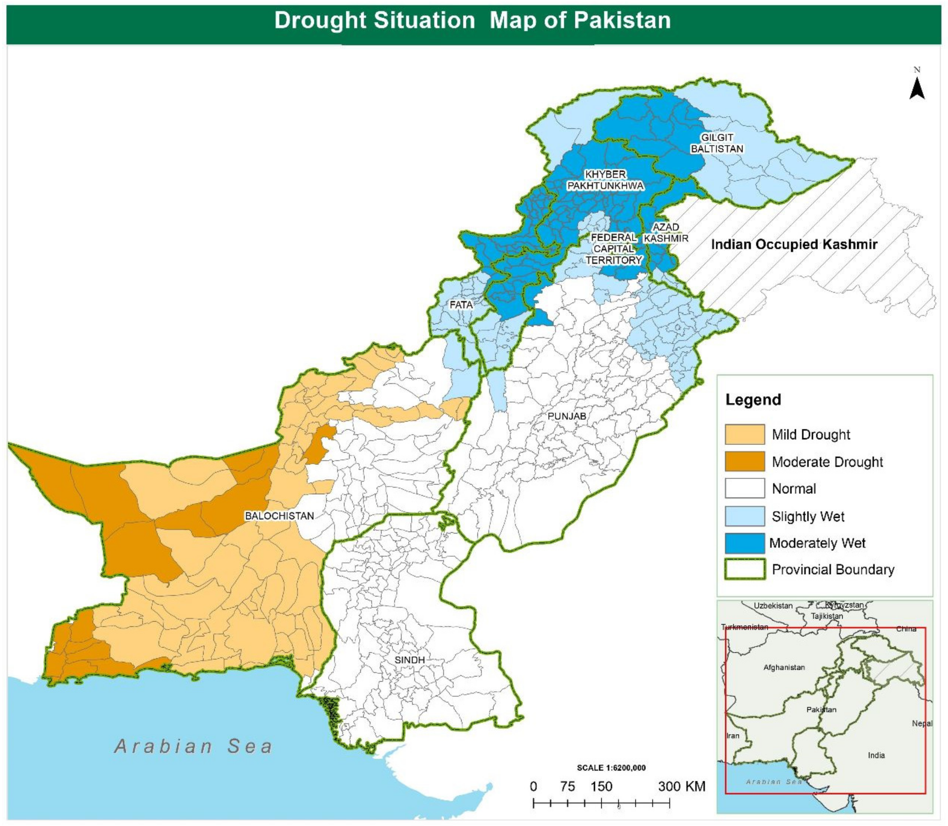
Figure 3. Illustration of the situation of droughts in all Pakistani districts.
2.3. Cyclones
There were 22 cyclones recorded in Pakistan Science from 1970–2020 [44]. While cyclones are common in the Arabian Sea, cyclones may cause severe damage to low-lying coastal areas. Typhoons primarily strike Sindh’s coast rather than Baluchistan’s. Cyclone 2A, a category three storm, wreaked havoc on the coastal regions of Badin and Thatta [45] in 1999, destroying 73 villages and displacing over 600,000 people. Property and agricultural disasters of up to USD 12.5 million have also been reported. According to the report of World Disaster [46], cyclones often batter Pakistan’s 960 km long coastal strip, inflicting extensive death and property destruction, particularly in the coastal districts of Gawadar, Badin, and Thatta.
2.4. Earthquakes
Earthquakes occur when the ground slips along a fault plane, causing ground shaking. Friction at the margins of active tectonic plates causes them to become stuck, accumulating tensions along the edges [47]. Ground shaking caused by earthquakes is a major contributor to infrastructure damage and the occurrence of secondary hazards such as landslides, flooding, tsunami, fire, liquefaction, and ground deformation [48].
With active Himalayan mountains in the north, Hindu Kush mountain ranges in the northwest, and Suleiman mountain ranges in the southwest, Pakistan is one of the world’s most seismically active areas [49][50]. The Indian tectonic plate, sub ducting beneath the Eurasian continent at a 31 mm/year pace, caused a high seismic hazard in Pakistan and the neighboring Indian and Afghan territories. The formation of the world’s tallest mountain ranges, the Karakoram, Himalaya, and Hindu Kush mountain ranges, originated from the collision of the Indian and Eurasian plates [51]. The mountain ranges of the Hindu Kush, Karakorum, and Kohe-Suleiman are particularly susceptible, and the resultant destruction can be enormous due to poor building construction [52]. The most recent catastrophic earthquake occurred in 2005 [53]. Over 85,000 people died, 138,000 were wounded, and 3.3 million people were displaced as a result of the disaster [54]. Hospitals, schools, and emergency services such as the police and armed forces were also shut down. There was too little infrastructure, and communication was severely hampered [55]. Due to the low quality and limited seismic resistance of structures, small and frequent earthquakes also inflict significant damage. A 6.4 magnitude earthquake struck Quetta and the adjacent regions on 28 October 2008, killing 160 people and wounding 370 others in Baluchistan [56]. As a consequence of the earthquake, many homes were damaged. The quake’s epicenter was 60 km northeast of Quetta. An earthquake of a magnitude of 7.2 struck Balochistan on 18 January 2011, killing numerous people and destroying 200 structures [57]. The quake was 50 km west of Dalbandin’s epicenter. On 16 April 2013, a powerful earthquake of a magnitude of 7.7 struck Quetta, causing vibrations throughout Pakistan, Iran, India, and several Gulf nations [58]. The earthquake’s epicenter was in Iran’s Sarawan region, near the Pakistan–Iran border. According to reports, around 34 people were killed, 80 were wounded, and 10,000 homes were destroyed as a consequence of the quake. A 7.5 magnitude earthquake hit Pakistan’s main cities on 25 October 2015, including the northern regions on Sunday, killing at least 200 people and injuring over 1000 more due to building collapses, landslides, and other quake-related events [59]. On 24 September 2019, a magnitude 5.8 earthquake struck Pakistan-administrated Kashmir and parts of Punjab Province [60], killing at least 37 people, including women and children, and wounding over 500 others, many of whom were severely injured. The quake hit Azad Jammu and Kashmir’s Mirpur area in the south. Hundreds of homes were partly demolished, roads were damaged, and the region’s hospitals were overwhelmed with casualties. Figure 4 illustrates a map of earthquake severity levels of all Pakistani districts. Most of the northern districts of Pakistan and north-western districts of Balochistan Province are vulnerable to earthquakes.
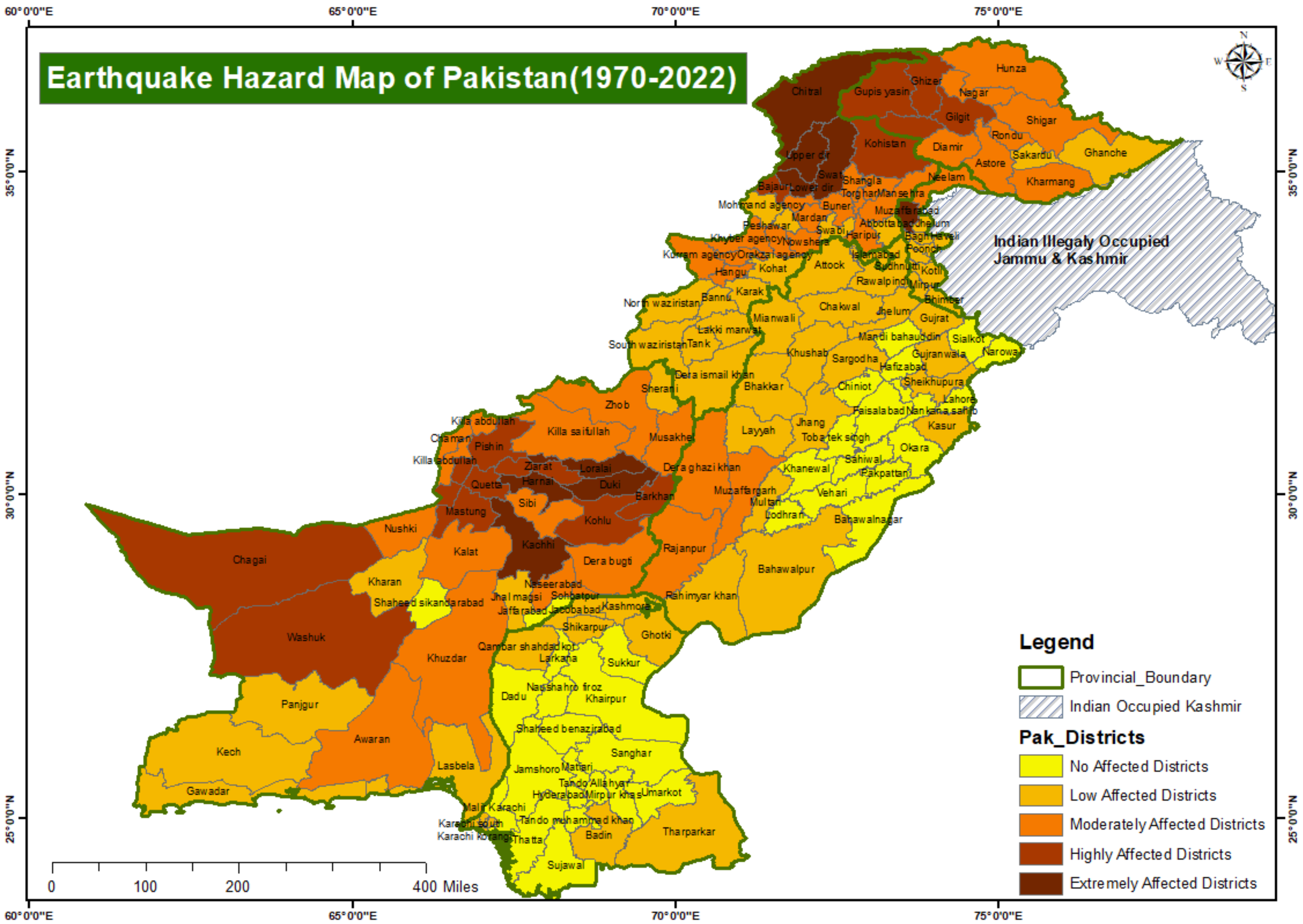
Figure 4. Pakistan Earthquake Hazard Map 1970–2020 showing the severity of earthquakes at district level.
2.5. Landslide
The term landslide has been used to describe the movement of earth material of varied sizes and origins for a long time. Landslides may vary from minor weather zone disturbances to the deep-rooted displacement of massive rock slab [61]. Their effect will be determined by their kind, depth of material, the pace of movement, environmental stressors, the volume of material invaded, and closeness to that slide, among other factors [62]. A large portion of the country is covered by steep and geomorphologically active mountains, apart from the huge alluvial Indus Basin, which is prone to periodic catastrophic floods and desertification (including waterlogging) [63]. In Pakistan, most landslides were discovered, recorded, and examined for analysis and statistical distribution. A huge landslide swept down the slopes of the isolated Hunza Valley in the Gilgit Baltistan region of northern Pakistan on 4 January 2010 [64][65]. Twenty people were killed, and twenty-six houses were destroyed when the town of Attabad was buried. The Hunza River was blocked by the landslide, and the newly created lake’s quickly increasing waters endangered communities even below and above the reservoir [66].
Several studies and methods have been formulated to predict slope stability in terms of safety factors [67][68][69][70][71]. Landslides and mass wasting frequently occur in the country’s hilly north and northwest. Landslides and slope collapses are frequent in Pakistan’s mountainous regions, especially during the monsoon season [72]. These steep regions are densely populated, putting enormous strain on natural resources, especially land resources. In Pakistan, the Himalayan Region has the most slide-affected regions. In the steep regions of the north and northwest regions, deforestation has increased soil creep. Landslides occur along roads constructed in mountain terrains such as the Muree Hills, Pir Punjal, and the Hindu Kush during the rainy season [73]. In Pakistan, no systematic and comprehensive research has been conducted to assess the issue’s scope. Figure 5 depicts a map showing the severity of landslides in Pakistan at the district level. The authors appreciate the reviewer’s remarks. The landslide zoning map is based on the number of occurrences of landslides in the past 50 years. The districts where landslides occur frequently are classified as severely vulnerable to landslides, while the districts where low landslides occur rarely are termed as less severe landslides. According to the map, the northern districts of Pakistan are highly vulnerable to the landslides.
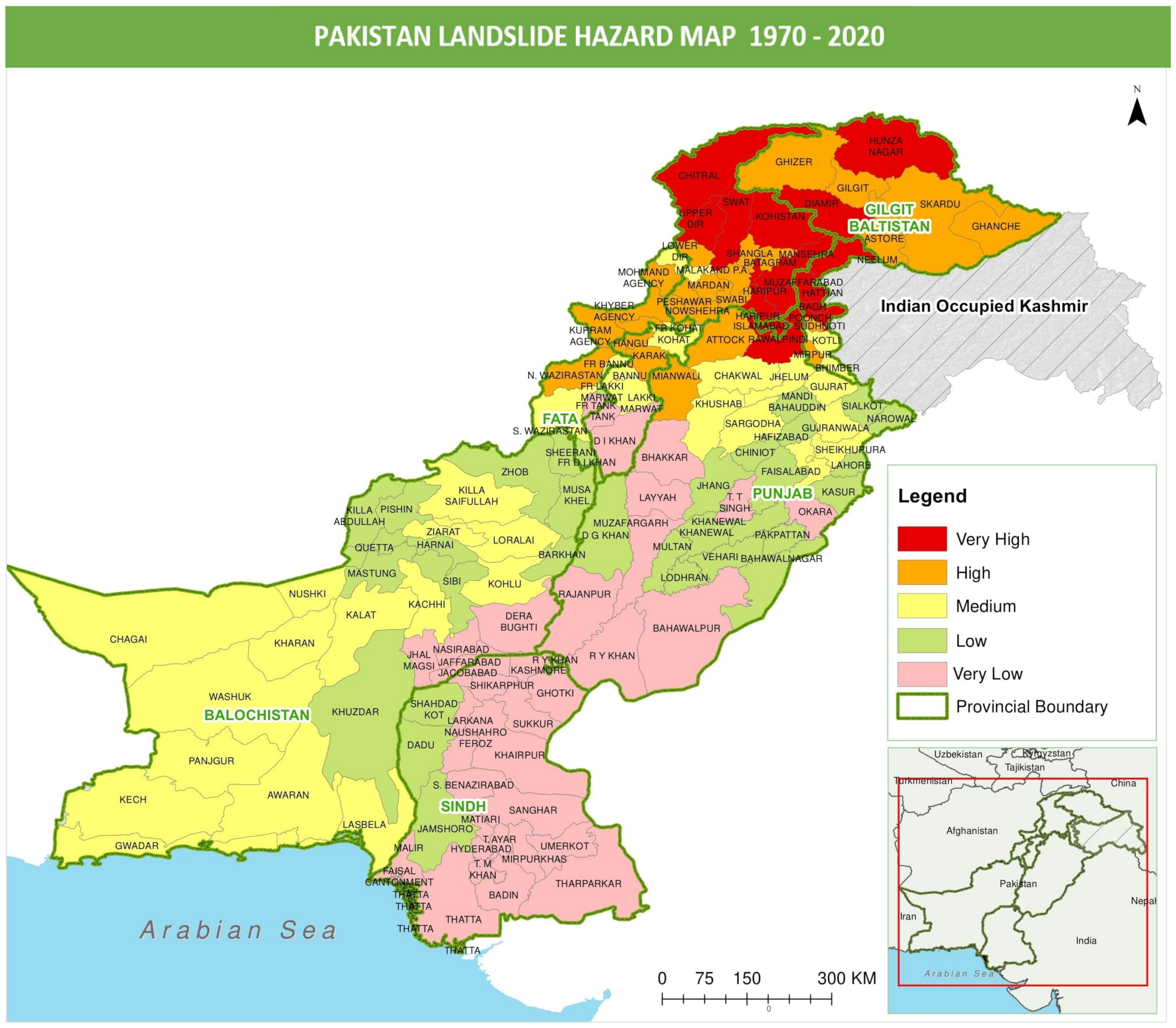
Figure 5. Pakistan Landslide Hazard Map 1970–2020 showing the intensity of landslides at district level.
Natural occurrences such as earthquakes and rains contribute to the landslide issue. In Pakistan, improper infrastructure projects, housing, deforestation, overgrazing, and insufficient agricultural techniques are the leading causes of slope destabilization, resulting in landslides [74]. These landslides not only endanger lives, property, and the environment but also result in significant economic losses owing to the disruption of communication and infrastructure networks.
2.6. Heatwave
Heatwaves are a common natural climatic hazard that has noticeable consequences for both people and biophysical systems. Worldwide, the frequency of reported hot days has been three times greater than recorded cold days during the last decade. A heat wave is a prolonged stretch of hot weather that is unusually hot for the time of year. A heatwave is also a long stretch of hot weather often accompanied by high humidity [75]. The World Meteorological Organization (WMO) defines a heat wave as “when the daily maximum temperature for more than five consecutive days surpasses the average maximum temperature by 5 degrees Celsius over the usual temperature of a region”. Heatwaves are frequent in Pakistan’s plains during the months leading up to the monsoon season (May and June) [76].
Heat wave occurrences may be divided into two categories based on their physical characteristics: dry and wet heat waves. Dry heat waves are characterized by dry weather, clear sky, and high solar radiation inputs. Windy conditions may also be present, which may exacerbate heat stress. Dry heat waves are most common in continental or Mediterranean climates or where the air is heated adiabatically [77][78]. On the other hand, moist heat waves are marked by extremely hot, uncomfortable, humid circumstances throughout the day and night, frequently with nighttime cloud cover, which inhibits the escape of heat collected during the day and therefore offers no respite at night [79]. Heat waves such as these are common in temperate and marine climates in the mid-latitudes, and they may be indigenous in certain areas. Heat waves are more likely to occur in places with a highly changeable summer climate or a clear hot season as a consequence of these features. They may, therefore, arise from various large-scale meteorological circumstances and climate-related mechanical processes.
In June 2015, Pakistan was hit by a severe heat wave, resulting in many deaths, particularly in Karachi [80]. From the 17th to the 24th of June, most of the country was engulfed in a heat wave. High temperatures were reported in the southern regions of the nation on 20 June. Temperatures varied from 49 degrees Celsius in Larkana and Sibi to 45 degrees Celsius in Karachi [81][82]. Multan in southern Punjab reported a temperature of 40 degrees Celsius, while Sibi and Turbat in Balochistan Province saw temperatures of 49 degrees Celsius. The regions of Pakistan where a heat wave with maximum temperatures of more than 45 °C swept over included much of southern Punjab, northern and western Sindh, as well as Karachi [83]. Due to the heatwave, heatstroke-related deaths were recorded in Karachi, Hyderabad, Noshero Feroz, Dadu, Badin, Thatta, and Tharparkar.
As mentioned above, Pakistan is having trouble with the average temperature rising as a result of climate change. In Pakistan, heatwaves are increasingly more frequent than ever. Figure 6 demonstrates the prevalence of heatwaves in various Sindh districts as well as the majority of south Punjab districts. Heatwaves also occur in Karachi, the largest metropolis in Pakistan. Baluchistan’s District Chaghi, Kech, was severely impacted by previous heatwaves. The impact of urban heat waves has increased in many Pakistani cities due to fast and unsustainable growth. In Pakistan, deforestation is a significant contributor to heatwaves. A significant contributor to Pakistan’s rising trend of heatwaves is also the trend of global climate change.
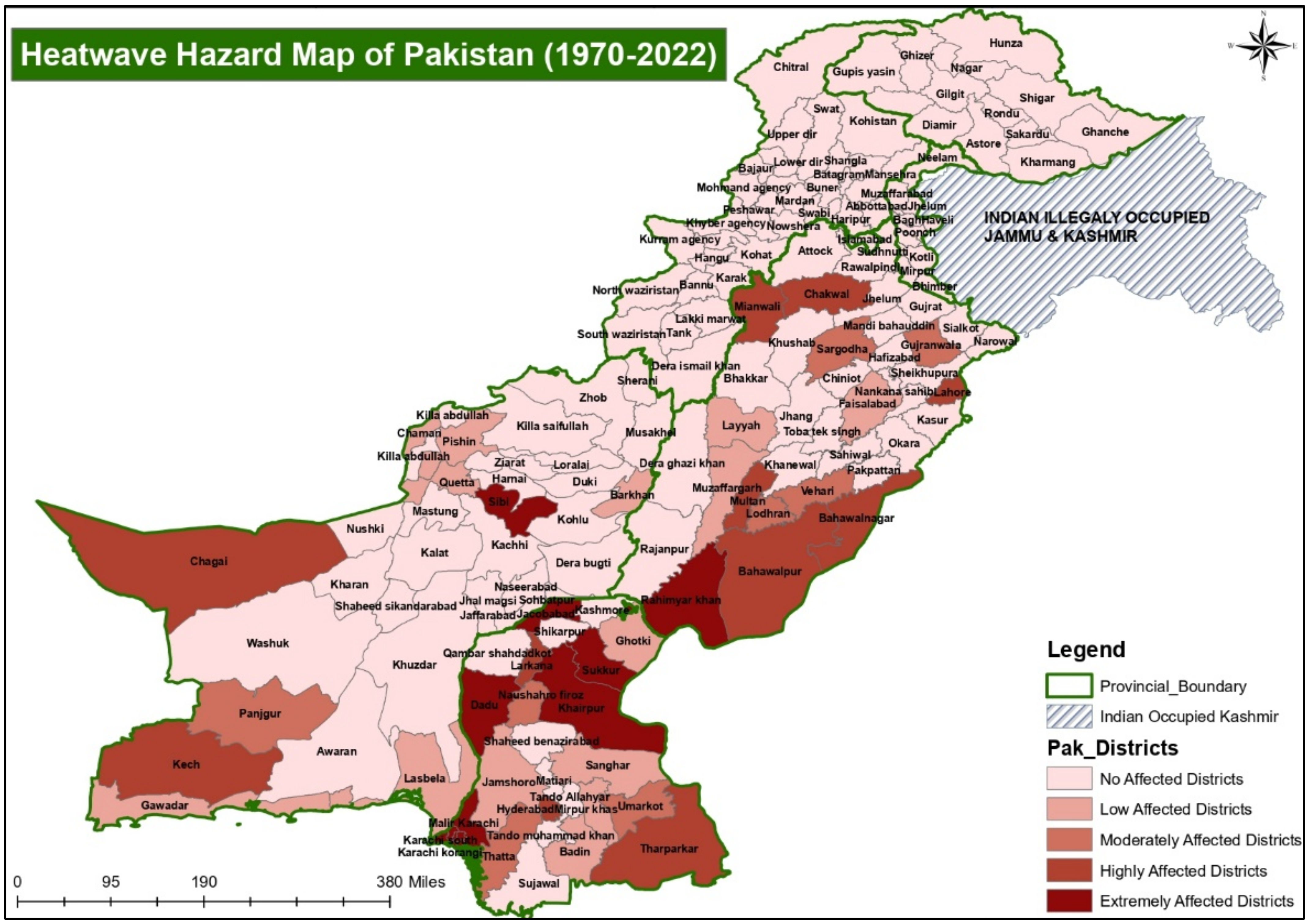
Figure 6. Pakistan Landslide Hazard Map 1970–2020 showing the intensity of heatwaves at district level.
2.7. Glacial Lake Outburst Floods (GLOFs)
Glacial lake outburst flood (GLOF) is another frequent natural disaster. Pakistan’s Karakoram Himalayas are experiencing a phenomenon of GLOF [84]. In the upper catchments of Pakistan’s main rivers, there are 2600 glacial lakes, all of which are proglacial. These glacial lakes may jeopardize all development projects in the immediate downstream region of the lakes, including different hydroelectric power projects, bridges, highways, and low-lying population concentrations. In 2008, five GLOF incidents were recorded from the Hunza Valley’s Gojal hamlet, inflicting significant damage to the infrastructure of these regions. Although the local community has made effective small-scale measures to drain a few lakes in the Ghulkin Glacier, Pakistan currently lacks a comprehensive mitigation scheme to minimize the danger presented by the GLOF hazard [26]. The GLOF event may not always directly impact human settlements, but it may create secondary dangers in certain instances, such as in the case of Pingal Lake in Gupis Tehsil.
Many glacial lakes are created along the lateral moraines along the glacier’s edges. The lateral moraines form a linear high that usually runs parallel to the glacial drift direction. This forms a glacial lake by creating a linear depression between the lateral moraine and the projecting boulders. Global warming is the source of heat in the Himalayas, Karakoram, and Hindukush, amplifying glacier melting, lake creation, and outburst [85]. A debacle, jokulhlaup, alluvion, or glacial lake outburst flood are all names used to describe the abrupt release of high water flow from glaciers. Because there are numerous glacial lakes in their catchment regions, the areas of Kalam, Bahrain, and Madyan in Swat Valley are susceptible. They may be affected by a GLOF event in the future. Kalam is located at the confluence of five main tributaries of streams that flow straight into over 15 glacial lakes, including Kandol Lake [86].
Similarly, Bahrain is vulnerable to more than ten glacial lakes, which may wreak havoc on the city of Bahrain, which is located on the Bahrain River’s debris fan. Shiringal is the other populated area of the Swat Valley, with nine glacial lakes, including a couple of lakes in the catchment area of the nearby Barikot Village. In Chitral, a few GLOF events have been reported from Yarkhun Lasht or Yarkhun Valley, including Boni, which may be linked to the glacial lakes of the Broghil area [87]. The intensity of GLOF at the district levels in Pakistan is shown in Figure 7. Any GLOF event may be triggered by several causes, including seismic activity, volcanic activity, landslides, rockfall, etc.
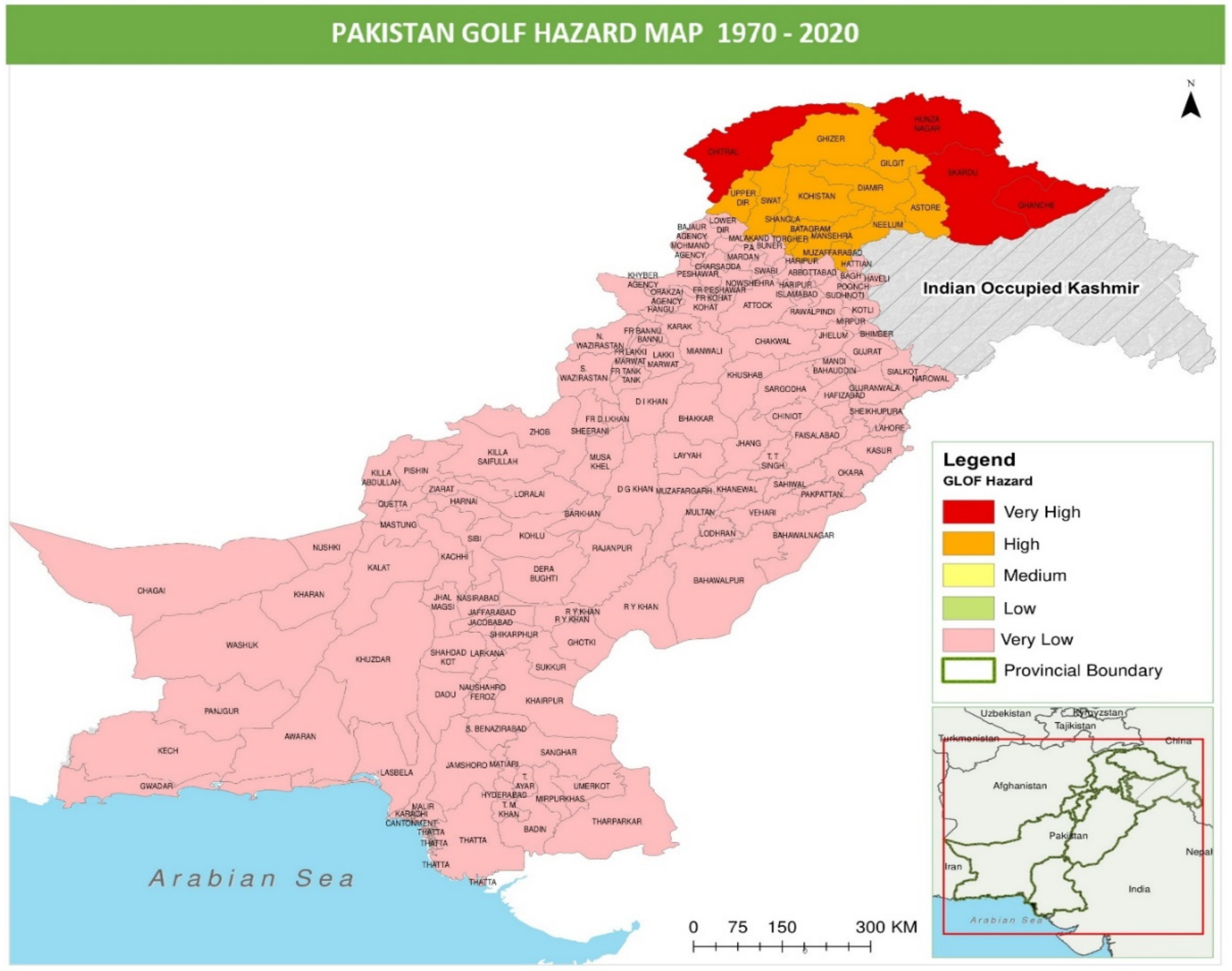
Figure 7. Pakistan GLOF Hazard Map 1970–2020 showing the intensity of GLOF at district level.
References
- Lerner-Lam, A. Assessing global exposure to natural hazards: Progress and future trends. Environ. Hazards 2007, 7, 10–19. Available online: https://www.tandfonline.com/doi/abs/10.1016/j.envhaz.2007.04.007 (accessed on 24 May 2021).
- Linnerooth-Bayer, J.; Hochrainer-Stigler, S. Financial instruments for disaster risk management and climate change adaptation. Clim. Change 2015, 133, 85–100.
- Mirza, M.M.Q. Climate change and extreme weather events: Can developing countries adapt? Clim. Policy 2003, 3, 233–248.
- Eckstein, D.; Hutfils, H.; Winges, M. Global Climate Risk Index 2019; GermanWatch: Bonn, Germany, 2019.
- Shah, I.; Elahi, N.; Alam, A.; Dawar, S.; Dogar, A.A. Institutional arrangement for disaster risk management: Evidence from Pakistan. Int. J. Disaster Risk Reduct. 2020, 51, 101784.
- Calligaris, C.; Michele, C.; Shahina, T.; Hawas, K. Attabad landslide on 4th January 2010: A pakistani disaster. In Proceedings of the The Second World Landslide Forum, Rome, Italy, 3–9 October 2011; p. 614.
- Hussain, M.; Abeer, N.; Ali, S.; Khan, A.Q.; Kiani, M.H.; Tahir, M.A. Geotechnical aspects of Attabad landslide dam. J. Himal. Earth Sci. 2012, 45, 51.
- Petley, D.N.; Rosser, N.J.; Karim, D.; Wali, S.; Ali, N.; Nasab, N.; Shaban, K. Non-seismic landslide hazards along the Himalayan Arc. In Geologically Active; CRC Press: London, UK, 2010; pp. 143–154.
- Sökefeld, M. Visualising disaster: Gojal after the Attabad landslide in Northern Pakistan. Tsantsa Z. Schweiz. Ethnol. Ges. 2012, 17, 212–224.
- Ahmed, Z. Disaster risks and disaster management policies and practices in Pakistan: A critical analysis of Disaster Management Act 2010 of Pakistan. Int. J. Disaster Risk Reduct. 2013, 4, 15–20.
- Ainuddin, S.; Aldrich, D.P.; Routray, J.K.; Ainuddin, S.; Achkazai, A. The need for local involvement: Decentralization of disaster management institutions in Baluchistan, Pakistan. Int. J. Disaster Risk Reduct. 2013, 6, 50–58.
- Hussain, M.; Arsalan, M.H.; Siddiqi, K.; Naseem, B.; Rabab, U. Emerging geo-information technologies (GIT) for natural disaster management in Pakistan: An overview. In Proceedings of the 2nd International Conference on Recent Advances in Space Technologies RAST 2005, Istanbul, Turkey, 9–11 June 2005; pp. 487–493.
- Early Warning Systems: Supporting Adaptation and Disaster Risk Reduction—WMO/UN Office for Disaster Risk Reduction. 2022. Available online: https://public.wmo.int/en/resources/united_in_science (accessed on 4 September 2022).
- Kron, W. Natural Disasters: Lessons from the Past—Concerns for the Future. Geneva Pap. Risk Insur. Issues Pract. 2000, 25, 570–581.
- Vlachogiannis, D.; Sfetsos, A.; Markantonis, I.; Politi, N.; Karozis, S.; Gounaris, N. Quantifying the Occurrence of Multi-Hazards Due to Climate Change. Appl. Sci. 2022, 12, 1218.
- Hsu, E.L. Must disasters be rapidly occurring? The case for an expanded temporal typology of disasters. Time Soc. 2019, 28, 904–921.
- NDMA. Available online: https://cms.ndma.gov.pk/publications (accessed on 10 October 2022).
- Naseer, S.; Haq, T.U.; Khan, A.; Tanoli, J.I.; Khan, N.G.; Shah, S.T.H. GIS-based spatial landslide distribution analysis of district Neelum, AJ&K, Pakistan. Nat. Hazards 2021, 106, 965–989.
- NDMA Report. 2018. Available online: https://cms.ndma.gov.pk/storage/app/public/publications/September2022/ZyBmIrEtYr5bAlvnlES8.pdf (accessed on 25 May 2021).
- Ullah, W.; Takaaki, N. Climate change vulnerability of Pakistan towards natural disasters: A review. Int. J. Environ. Prot. Policy 2016, 4, 126.
- Fontaine, B.; Janicot, S.; Monerie, P.-A. Recent changes in air temperature, heat waves occurrences, and atmospheric circulation in Northern Africa. J. Geophys. Res. Atmos. 2013, 118, 8536–8552.
- Friedlingstein, P.; Solomon, S.; Plattner, G.K.; Knutti, R.; Ciais, P.; Raupach, M.R. Long-term climate implications of twenty-first century options for carbon dioxide emission mitigation. Nat. Clim. Change 2011, 1, 457–461.
- Solomon, S.; Plattner, G.-K.; Knutti, R.; Friedlingstein, P. Irreversible climate change due to carbon dioxide emissions. Proc. Natl. Acad. Sci. USA 2009, 106, 1704–1709.
- Kronstadt, K.A. Flooding in Pakistan: Overview and Issues for Congress; Congressional Research Service: Washington, DC, USA, 2010.
- Nawaz, U.; Shahid, S.; Ahmad, R.; Ibrahim, M.U.; Wajid, A.; Manan, A.; Qureshi, M.I. Indus Basin Irrigation System and climatic trends regarding glacial regimes and water runoff. J. Environ. J. Agric. Sci. 2016, 9, 28–36.
- Ashraf, A.; Naz, R.; Roohi, R. Glacial lake outburst flood hazards in Hindukush, Karakoram and Himalayan Ranges of Pakistan: Implications and risk analysis. Geomat. Nat. Hazards Risk 2012, 3, 113–132.
- Gilany, N.; Iqbal, J. Geospatial analysis and simulation of glacial lake outburst flood hazard in Shyok Basin of Pakistan. Environ. Earth Sci. 2020, 79, 139.
- Hashmi, H.N.; Siddiqui, Q.T.M.; Ghumman, A.R.; Kamal, M.A.; Mughal, H.R. A critical analysis of 2010 floods in Pakistan. Afr. J. Agric. Res. 2012, 7, 1054–1067.
- Ahmad, F.; Kazmi, S.F.; Pervez, T. Human response to hydro-meteorological disasters: A case study of the 2010 flash floods in Pakistan. J. Geogr. Reg. Plan. 2011, 4, 518–524.
- Webster, P.J.; Toma, V.E.; Kim, H.-M. Were the 2010 Pakistan floods predictable? Geophys. Res. Lett. 2011, 38, L04806.
- Siddiqi, A. The Emerging Social Contract: State-Citizen Interaction after the Floods of 2010 and 2011 in Southern Sindh, Pakistan. IDS Bull. 2013, 44, 94–102.
- Wasim, M.A. The landscape of disaster management in Pakistan: Gaps in the legal framework. In Disaster Law; Routledge: Abingdon-on-Thames, UK, 2017; pp. 65–179.
- Pakistan: Flood Extend (16 September 2010) and Flood Losses (13 October 2010). Available online: https://reliefweb.int/map/pakistan/pakistan-flood-extend-16-sept-2010-and-flood-losses-13-oct-2010 (accessed on 29 October 2022).
- Campbell, J.G.; Pradesh, H. Inventory of Glaciers, Glacial Lakes and the Identification of Potential Glacial Lake Outburst Floods (GLOFs) Affected by Global Warming in the Mountains of India, Pakistan and China/Tibet Autonomous Region; International Centre for Integrated Mountain Development: Kathmandu, Nepal, 2005.
- Ghaffar, A.; Javid, M. Impact of global warming on monsoon variability in Pakistan. J. Anim. Plant Sci. 2011, 21, 107–110.
- Anjum, S.A.; Saleem, M.F.; Cheema, M.A.; Bilal, M.F.; Khaliq, T. An assessment to vulnerability, extent, characteristics and severity of drought hazard in Pakistan. Pak. J. Sci. 2012, 64, 138.
- Siddiqui, S.; Safi, M.W.A. Assessing the socio-economic and environmental impacts of 2014 drought in District Tharparkar, Sindh-Pakistan. Int. J. Econ. Environ. Geol. 2019, 8, 15.
- Ashraf, M.; Routray, J.K. Spatio-temporal characteristics of precipitation and drought in Balochistan Province, Pakistan. Nat. Hazards 2015, 77, 229–254.
- Bilal, M.; Liaqat, M.U.; Cheema, M.J.M.; Mahmood, T.; Khan, Q. Spatial drought monitoring in Thar desert using satellite-based drought indices and geo-informatics techniques. Proceedings 2018, 2, 179.
- Zaigham, N.A. Strategic Sustainable Development of Groundwater in Thar Desert of Pakistan. Water Resour. South Present Scenar. Future Prospect. 2003, 56, 61–74.
- Ahmed, K.; Shahid, S.; Harun, S.; Wang, X. Characterization of seasonal droughts in Balochistan Province, Pakistan. Stoch. Environ. Res. Risk Assess. 2016, 30, 747–762.
- Sarwar, A. Droughts in Pakistan—A socio-political perspective. In Droughts and Integrated Water Resource Management in South Asia: Issues, Alternatives and Futures; SAGE Publications: New Delhi, India, 2008; pp. 200–230.
- TORRES, C.A.-Q. Drought in Tharparkar: From seasonal to forced migration. State Environ. Migr. 2015, 19, 64.
- Babar, H. Detailed history of Cyclones in Pakistan. 2011. Available online: https://pakistanweatherportal.com/2011/03/31/history-of-cyclones-in-pakistan/ (accessed on 25 September 2021).
- Kidwai, S.; Ahmed, W.; Tabrez, S.M.; Zhang, J.; Giosan, L.; Clift, P.; Inam, A. The Indus delta—Catchment, river, coast, and people. In Coasts and Estuaries; Elsevier: Amsterdam, The Netherlands, 2019; pp. 213–232.
- WDR. 2003. Available online: https://www.google.com/search?q=world+disaster+report+2003&sxsrf=ALeKk02pnT7BVVfqnMsicJ2t99qG7nToWw%3A1625982325395&ei=dYXqYMvBF-yAjLsPy-Kn4Ao&oq=world+disaster+report+2003&gs_lcp=Cgdnd3Mtd2l6EAMyBQghEKABOgQIIxAnOgUIABCRAjoKCAAQsQMQgwEQQzoICAAQsQMQgwE6BQgAELEDOggIABCxAxCRAjoECAAQQzoECC4QQzoHCAAQsQMQQzoCCAA6AgguOgUILhCTAjoGCAAQFhAeOggIABAWEAoQHkoECEEYAFDbEliBVWCjV2gAcAJ4AIAB4AOIAdc7kgEIMi0yMi4zLjKYAQCgAQGqAQdnd3Mtd2l6wAEB&sclient=gws-wiz&ved=0ahUKEwiL0KmXqNrxAhVsAGMBHUvxCawQ4dUDCA4&uact=5 (accessed on 11 July 2021).
- Hanks, T.C. Earthquake stress drops, ambient tectonic stresses and stresses that drive plate motions. In Stress in the Earth; Springer: Basel, Switzerland, 1977; pp. 441–458.
- McKenzie, D.; Jackson, J. Tsunami earthquake generation by the release of gravitational potential energy. Earth Planet. Sci. Lett. 2012, 345, 1–8.
- Bernard, M.; Shen-Tu, B.; Holt, W.E.; Davis, D.M. Kinematics of active deformation in the Sulaiman Lobe and Range, Pakistan. J. Geophys. Res. Solid Earth 2000, 105, 13253–13279.
- Sultan, M. Seismic hazard analysis of Pakistan. J. Geol. Geosci. 2015, 4, 190.
- Searle, M.P.; Robb, L.J.; Gardiner, N.J. Tectonic Processes and Metallogeny along the Tethyan Mountain Ranges of the Middle East and South Asia (Oman, Himalaya, Karakoram, Tibet, Myanmar, Thailand, Malaysia). J. Geol. Geosci. 2016, 19, 301–327.
- Bothara, J.K.; Hiçyılmaz, K.M. General observations of building behaviour during the 8th October 2005 Pakistan earthquake. Bull. N. Z. Soc. Earthq. Eng. 2008, 41, 209–233.
- Mahmood, I.; Kidwai, A.A.; Qureshi, S.N.; Iqbal, M.F.; Atique, L. Revisiting major earthquakes in Pakistan. Geol. Today 2015, 31, 33–38.
- Buttenheim, A. Impact evaluation in the post-disaster setting: A case study of the 2005 Pakistan earthquake. J. Dev. Eff. 2010, 2, 197–227.
- Ali, S.M.; Khan, A.N.; Rahman, S.; Reinhorn, A.M. A survey of damages to bridges in Pakistan after the major earthquake of 8 October 2005. Earthq. Spectra 2011, 27, 947–970.
- Maqsood, S.T.; Schwarz, J. Building Vulnerability and Damage during the 2008 Baluchistan Earthquake in Pakistan and Past Experiences. Seismol. Res. Lett. 2010, 81, 514–525.
- Rehman, S.U.; Azeem, T.; El-Aal, A.E.-A.K.A.; Nasir, A. Parameterization of 18th January 2011 earthquake in Dalbadin Region, Southwest Pakistan. NRIAG J. Astron. Geophys. 2013, 2, 203–211.
- Vallage, A.; Klinger, Y.; Lacassin, R.; Delorme, A.; Pierrot-Deseilligny, M. Geological structures control on earthquake ruptures: The Mw7.7, 2013, Balochistan earthquake, Pakistan. Geophys. Res. Lett. 2016, 43, 10155–10163.
- Ahmed, J.; Shah, M.; Zafar, W.A.; Amin, M.A.; Iqbal, T. Seismoionospheric anomalies associated with earthquakes from the analysis of the ionosonde data. J. Atmos. Sol. Terr. Phys. 2018, 179, 450–458.
- Khan, M.Y.; Turab, S.A.; Riaz, M.S.; Atekwana, E.A.; Muhammad, S.; Butt, N.A.; Abbas, S.M.; Zafar, W.A.; Ohenhen, L.O. Investigation of coseismic liquefaction-induced ground deformation associated with the 2019 Mw 5.8 Mirpur, Pakistan, earthquake using near-surface electrical resistivity tomography and geological data. Near Surf. Geophys. 2021, 19, 169–182.
- Hungr, O. Dynamics of rapid landslides. In Progress in Landslide Science; Springer: Berlin/Heidelberg, Germany, 2007; pp. 47–57.
- Causes, L. Landslide Types and Processes; U.S. Geological Survey: Reston, VA, USA, 2001.
- Owen, L.A.; England, J. Observations on rock glaciers in the Himalayas and Karakoram Mountains of northern Pakistan and India. Geomorphology 1998, 26, 199–213.
- Gardezi, H.; Bilal, M.; Cheng, Q.; Xing, A.; Zhuang, Y.; Masood, T. A comparative analysis of attabad landslide on january 4, 2010, using two numerical models. Nat. Hazards 2021, 107, 519–538.
- Sökefeld, M. The Attabad landslide and the politics of disaster in Gojal, Gilgit-Baltistan. In Negotiating Disasters: Politics, Representation, Meanings; Peter Lang: Berlin, Germany, 2012; p. 31.
- Chen, X.; Cui, P.; You, Y.; Cheng, Z.; Khan, A.; Ye, C.; Zhang, S. Dam-break risk analysis of the Attabad landslide dam in Pakistan and emergency countermeasures. Landslides 2017, 14, 675–683.
- Duncan, J.M.; Wright, S.G. The accuracy of equilibrium methods of slope stability analysis. Eng. Geol. 1980, 16, 5–17.
- Fredlund, D.G.; Krahn, J. Comparison of slope stability methods of analysis. Can. Geotech. J. 1977, 14, 429–439.
- Hovland, H.J. Three-dimensional slope stability analysis method. J. Geotech. Eng. Div. 1977, 103, 971–986.
- Kliche, C.A. Rock Slope Stability; Society for Mining, Metallurgy, and Exploration: Englewood, CO, USA, 1999.
- Moawwez, M.A.; Wang, J.-P.; Hussain, M.A. Development of empirical correlations for limit equilibrium methods of slope stability analysis. Arab. J. Geosci. 2021, 14, 2020.
- Hewitt, K. Catastrophic landslides and their effects on the Upper Indus streams, Karakoram Himalaya, northern Pakistan. Geomorphology 1998, 26, 47–80.
- Ahmed, K.A.; Khan, S.; Sultan, M.; Nisar, U.B.; Mughal, M.R.; Qureshi, S.N. Landslides assessment using geophysical and passive radon exhalation detection techniques in Murree Hills, northern Pakistan: Implication for environmental hazard assessment. J. Earth Syst. Sci. 2020, 129, 53.
- Rahman, A.; Khan, A.N.; Collins, A.E. Analysis of landslide causes and associated damages in the Kashmir Himalayas of Pakistan. Nat. Hazards 2014, 71, 803–821.
- Xu, Z.; FitzGerald, G.; Guo, Y.; Jalaludin, B.; Tong, S. Impact of heatwave on mortality under different heatwave definitions: A systematic review and meta-analysis. Environ. Int. 2016, 89, 193–203.
- Zahid, M.; Rasul, G. Changing trends of thermal extremes in Pakistan. Clim. Change 2012, 113, 883–896.
- Khan, N.; Shahid, S.; Ismail, T.; Ahmed, K.; Nawaz, N. Trends in heat wave related indices in Pakistan. Stoch. Environ. Res. Risk Assess. 2019, 33, 287–302.
- Zahid, M.; Rasul, G. Rise in summer heat index over Pakistan. Pak. J. Meteorol. 2010, 6, 85–96.
- Russo, S.; Sillmann, J.; Sterl, A. Humid heat waves at different warming levels. Sci. Rep. 2017, 7, 7477.
- MBaig, A.; Waheed, S.; Mian, A.; Hussain, E. Unforgiving heat wave deaths in the largest metropolitan city of Pakistan: Lessons learned. Eurasian J. Emerg. Med. 2015, 14, 209.
- Masood, I.; Majid, Z.; Sohail, S.; Zia, A.; Raza, S. The deadly heat wave of Pakistan, June 2015. Int. J. Occup. Environ. Med. 2015, 6, 247.
- Salim, A.; Ahmed, A.; Ashraf, N.; Ashar, M. Deadly Heat Wavein Karachi, July 2015: Negligence or Mismanagement? Int. J. Occup. Environ. Med. 2015, 6, 249.
- Wehner, M.; Stone, D.; Krishnan, H.; AchutaRao, K. Castillo The deadly combination of heat and humidity in India and Pakistan in summer 2015. Bull. Am. Meteorol. Soc. 2016, 97, S81–S86.
- Veh, G.; Korup, O.; von Specht, S.; Roessner, S.; Walz, A. Unchanged frequency of moraine-dammed glacial lake outburst floods in the Himalaya. Nat. Clim. Change 2019, 9, 379–383.
- Bazai, N.A.; Cui, P.; Carling, P.A.; Wang, H.; Hassan, J.; Liu, D.; Zhang, G.; Jin, W. Increasing glacial lake outburst flood hazard in response to surge glaciers in the Karakoram. Earth-Sci. Rev. 2020, 212, 103432.
- Rehman, G. GLOF Risk and Reduction Approaches in Pakistan. In Disaster Risk Reduction Approaches in Pakistan; Springer: Tokyo, Japan, 2015; pp. 217–237.
- Uddin, N.; Anjum, M.; Uddin, S.; Uddin, Z. Debris flow hazard of glacial lake in Chitral, Pakistan. In Proceedings of the 6th Conference Debris Flows: Disasters, Risk, Forecast, Protection, Dushanbe–Khorog, Tajikistan, 6–10 September 2020.
More
Information
Subjects:
Engineering, Geological; Engineering, Civil
Contributors
MDPI registered users' name will be linked to their SciProfiles pages. To register with us, please refer to https://encyclopedia.pub/register
:
View Times:
12.8K
Revisions:
2 times
(View History)
Update Date:
08 Feb 2023
Table of Contents


Notice
You are not a member of the advisory board for this topic. If you want to update advisory board member profile, please contact office@encyclopedia.pub.
OK
Confirm
Only members of the Encyclopedia advisory board for this topic are allowed to note entries. Would you like to become an advisory board member of the Encyclopedia?
Yes
No
${ textCharacter }/${ maxCharacter }
Submit
Cancel
Back
Comments
${ item }
|
${ item.createdUser.fullName }
${ item.createdAt }
${ item.vote }
${ item.reply }
Delete
${ reply.createdUser.fullName }
${ reply.createdAt }
${ reply.vote }
Delete
There is no reply to this comment~
${ item.replyTextCharacter }/${ item.replyMaxCharacter }
Submit
Cancel
More
No more~
There is no comment~
${ textCharacter }/${ maxCharacter }
Submit
Cancel
${ selectedItem.replyTextCharacter }/${ selectedItem.replyMaxCharacter }
Submit
Cancel
Confirm
Are you sure to Delete?
Yes
No