 +1 credit
| Version | Summary | Created by | Modification | Content Size | Created at | Operation |
|---|---|---|---|---|---|---|
| 1 | Sumudu Senanayake | + 5869 word(s) | 5869 | 2020-12-16 10:16:38 | | | |
| 2 | Sumudu Senanayake | -62 word(s) | 5807 | 2020-12-22 05:40:17 | | | | |
| 3 | Dean Liu | -2254 word(s) | 3553 | 2020-12-22 08:53:45 | | |
Video Upload Options
Soil erosion is a severe threat to food production systems globally. Food production in farming systems decreases with increasing soil erosion hazards. Hazard is a situation or potential condition to harm or threat to life, health or damage to property or environment, social and economic disruption. The mass movement of soil is an indicator of a soil erosion hazard. This includes gully erosion, riverbank erosion, rock-falls, debris-falls and landslides that can create damage to the environment and livelihoods.
1. Introduction
Soil erosion is a natural phenomenon. Intensification of soil erosion causes environmental, economic and social disturbances and hazardous situations[1]. It deteriorates the soil quality: loss of nutrients[2], changes in physical, chemical and biological processes[3] and reducing agriculture productivity[4] resulting in global food insecurity[5]. Human interference and climate variation lead to the intensification of soil erosion[6]. Many studies show that agricultural landscapes, mainly farming systems, are more vulnerable to soil erosion due to present climate variation [7][8]. Keating and McCown[9] described the farming system as an entire production system and management system on a particular farm or similar farms. The Food and Agriculture Organization defined the farming system as “a population of individual farm systems that have broadly similar resource bases, enterprise patterns, household livelihoods and constraints and for which similar development strategies and interventions would be appropriate. Thus a farming system can encompass a few dozen or many millions of households”[10]. When the erosion rate is accelerated beyond the level of the permissible rate, it leads to a hazard. Rahman et al.[11] defined a hazard as “a threatening situation to human life, property or environment.” The soil erosion hazard influences the landscape processes such as land productivity, hydrological processes and eventual human wellbeing. Therefore, soil erosion assessment is important in understanding landscape processes. However, soil erosion assessment is highly complex due to its multifactorial influences[12][13]. This complexity is reflected in the huge number of publications pertaining to the subject. Hence, climatic, biophysical, topographic and human interference (such as socio-economic and political factors) are needed to be considered for soil erosion assessment.
Since the 1930s, several soil erosion models have been developed and tested; however, it is still challenging for researchers to assess and predict soil erosion accurately due to its complex nature[3][14]. Karydas et al.[15] have identified 82 soil erosion models and classified them under eight geospatial categories. They identified the integration of geospatial techniques as a landmark change for the soil erosion assessment. In recent decades, soil erosion assessment integrated with geospatial technology has enabled the development of simplified models to assess complex situations. Geo-informatics is a field of study on the scientific investigation of economic, social, environmental, health & safety and security challenges in multiple disciplines by analyzing big geospatial and temporal data and interpretation of results for better understanding and decision-making[16]. It is widely applied in various disciplines of engineering, earth science, climate science & meteorology, agriculture, public health, archaeology, oceanography, military and so forth. The geo-informatics helps in the acquisition of different types of data on socio-economic and biophysical parameters using geospatial technology—geographic information systems (GIS), remote sensing (RS) and global positioning systems (GPS). It also facilitates data storage, management, analysis and visualization to develop new theories and methodological tools to address complex social and environmental challenges. Geo-informatics has great potential for soil erosion assessment[17] and benefited for combining soil erosion modelling in recent past.
2. Soil Erosion Hazards
Soil erosion by water, that is, “water erosion” has been identified as the major threat to the agriculture landscape and farming systems[18][19]. Water erosion in farmlands reduce the crop yield and change the land-use patterns that may induce a risk of food insecurity[20][21]. Water erosion greatly contributes to the soil erosion hazard[6][13]. Hazard is a situation or potential condition to harm or threat to life, health or damage to property or environment[22]. Researchers revealed increasing rainfall intensities and prolong seasonal dry periods due to climate variation have triggered an intensification of soil erosion and temporal probability of hazard occurrence such as mass movements[23]. The extent, frequency and magnitude of the soil erosion and its associated temporal probability of occurrence can be increased due to future climate change[8][24]. The anthropogenic factors such as land-use change and forest fires further exacerbated the soil erosion hazard situation[23][25]. Moreover, water erosion caused by environmental hazards was reported by many scholars with the main cause being highland developments in the recent past[1][26][27].
The mass movement of soil is an indicator of a soil erosion hazard. This includes gully erosion, riverbank erosion, rock-falls, debris-falls and landslides that can create damage to the environment and livelihoods. Annually, more than thousands of lives are lost due to mass soil movement worldwide[28]. However, Blaschke et al.[29] revealed that impacts of a mass movement on soil erosion and land productivity are under-rated in the literature. Thus, less research attention was given on soil erosion due to the mass movement. Most of the soil erosion hazards prevail during a rainy season or after heavy rain[17][30]. Mostly, the tropical agricultural lands are vulnerable to gully erosion and landslides due to heavy water erosion[1][31]. Researchers have identified that landslides and other types of mass movement are responsible for losses of thousands of lives and hundreds of millions of US dollars’ worth of property and agricultural losses every year[32]. Therefore, understanding the potential risk or susceptibility to soil erosion is very important for mitigation and risk minimization.
Several studies have highlighted sediment deposition in water sources and its impact on water quality, biodiversity and natural resources[31][33]. Wilkinson et al.[34] have pointed out that understanding of driving factors of gully initiation and assessing water erosion dynamics in the river basin of northeast Australia is important due to its influence on Great Barrier Reef lagoon. Therefore, it is vital to estimate flow discharge and corresponding erosion rates on steep-slope lands using realistic runoff and water erosion models. This information is needed to map for conserving natural resources, prevention and control soil erosion by aiming sustainable land management process [35]. Furthermore, Poesen[6] highlighted more research is needed on soil erosion runoff and sediment deposition with hydrological response related to present rainfall variation on sloping lands in order to identify better conservation plans.
2.1. Modelling of Soil Erosion
The natural soil erosion process is induced due to heavy rainfall, runoff, drought, snowfall, wind, fire and gravity. Soil erosion by water is the most significant factor of land degradation[14][36][37]. Water erosion can be observed throughout the world as one of the most important factors that can induce mass soil movement. For instance, United States’ agricultural lands are having an average annual water erosion 5–170 t ha−1 yr−1, China 150–200 t ha−1 yr−1, Australia 0.1–150 t ha−1 yr−1, India 0.3–40 t ha−1 yr−1, Belgium 3–30 t ha−1 yr−1, Ethiopia 8–42 t ha−1 yr−1, Colombia 0.2–61 t ha−1 yr−1, Brazil 60 t ha−1 yr−1 Europe 2.46 t ha−1 yr−1 and Russia 4.58 t ha−1 yr−1[17][32][38][39].
The tolerable threshold value of soil erosion depends on soil production functions that maintain by ecosystem service. Therefore, the rate of soil production varies with different regions[40]. Borrelli et al.[25] revealed generic tolerable soil erosion threshold value is 10 t ha−1 yr−1. However, the tolerable value of range between 4.5 and 11.2 t ha−1 yr−1 was proposed by the work of the United States Department of Agriculture. The European Environment Agency sets the threshold value between 1 t ha−1 yr−1 for shallow sandy soils and 5 t ha−1 yr−1 on deeper, well-developed soils. Bui, Hancock and Wilkinson[41] provided value of 0.85 t ha−1 yr−1 for Australia as reported by the Food and Agriculture Organization[40].
Research supports the assumption that rainfall accelerates soil erosion in hilly areas and watersheds because soil erosion is highly sensitive to precipitation[38][42]. The process of water erosion consists of detachment, transportation and deposition of sediment in a separate place[3][43][44]. There are several types of water erosion such as splash erosion, sheet or inter-rill, rill, gully or ravine[31][45]. Figure 1 shows the types of soil erosion by water. The kinetic energy of water drops detaches the soil surface into soil particles, which are known as splash erosion. These soil particles move with runoff water flow. These runoff water flows create tiny channels (rills) in hill slopes. When these water flows of rills connect, they cause the formation of gullies. This process can be described as gully erosion. The removal of soil layers is called sheet erosion. The rate of soil erosion depends on several key factors such as rainfall intensity, soil infiltration, amount of runoff water and slope length[46]. However, soil erosion may depend on some other factors such as anthropogenic activities as well. It is important to understand the process of soil erosion and its impacting factors in order to select an effective method for monitoring water erosion in the context of sustainable land management.
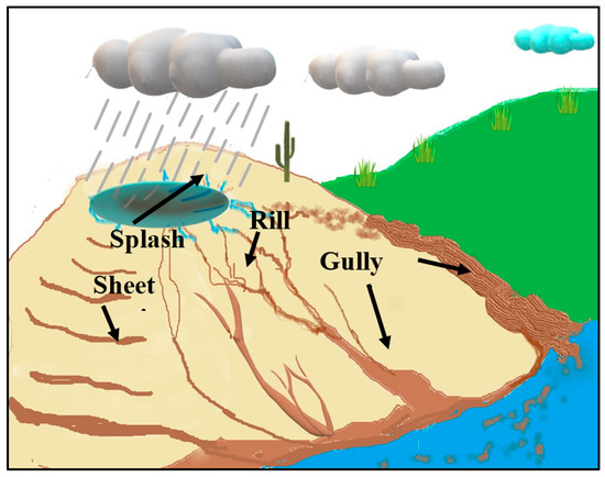
Figure 1. The types of soil erosion by water.
Water erosion assessment methods can be categorized into three main approaches: (i) the field plot experiment or fallout radionuclides methods using average soil loss measurements[47], (ii) the field survey method by visible soil erosion indicators and identification of soil erosion influencing factors[48] and (iii) soil erosion modelling[44]. The classification of soil erosion assessment methods shows in Figure 2. Soil erosion assessment using field experiments was done by many researchers over several decades[47][49]. Most of the methods were executed as field plot scale or watershed base experiments. Poesen[6] identified hydrological discharge on the hill slopes or catchments are dependent on the area and cannot generalize from a field plot experiment. The realistic runoff should be measured according to the relief and corresponding erosion rates on hill-slopes. These understandings of soil erosion runoff are important for better predicting sheet and rill erosion rates in different environments. Ganasri and Ramesh [6] indicated that most of these conventional methods of soil erosion assessments are expensive and time-consuming. However, soil erosion modelling approaches provide a quantitative and reliable estimation for the erosion process and sediment yield in a diverse environment [50][51].
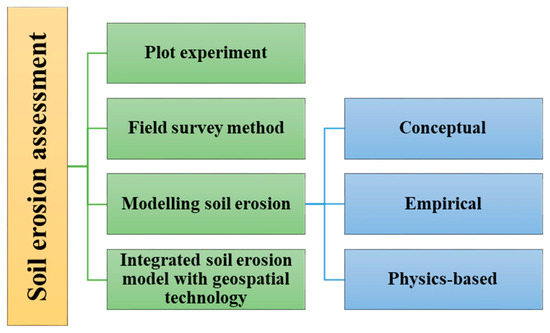
Figure 2. Classification of soil erosion assessment methods.
Numerous soil erosion models have been developed by utilizing different scientific methods and modelling approaches. In general, three categories of soil erosion model based on the nature of the basic algorithms exist (a) physics-based, (b) empirical and (c) conceptual models[31][42]. These three categories of soil modelling will be discussed briefly in the following sections.
2.1.1. Physics-Based Models
Physics-based models are built on field-based research and simulate climate, runoff, infiltration, water balance, plant growth and decomposition, tillage and consolidation. These models are on the basis of the physics of flow and sediment transport processes and their interaction on the transfer of mass, momentum and energy[52]. It can be applied for a range of experiments such as from a field plot scale to small watersheds and different time periods, including individual storm events, monthly, yearly or an average annual value, based on the data from several decades. Major limitations of these models are high complexity and computational costs. The Water Erosion Prediction Project (WEPP) model is an example of a commonly used physical process-based water erosion model [53]. It was developed as a system modelling approach for predicting and assessing soil loss and identifying watershed management practices for soil conservation.
2.1.2. Empirical Models
Empirical models are simplified natural processes based on experimental observations. Argent[54] explained the models that calibrate the relationship between input and output without a detailed description of the causes of each process. These equations are based on observations of the environment that can be statistically quantified and proven[55]. Hence, empirical models are frequently employed for soil erosion modelling and useful for identifying the sources of sediments and quantifying the erosion rates[56]. Empirical-based models have been widely used in soil erosion assessments. The Universal soil loss equation (USLE), the revised universal soil loss equation (RUSLE) and modified universal soil loss equation (MUSLE) are commonly employed empirical-base models Equation (1) for soil erosion assessments[57][58]. Tiwari et al.[59] compared runoff and soil loss amounts by RUSLE and WEPP models. They found RUSLE and WEPP models satisfactorily predicted soil loss for the analyzed conditions and RUSLE performance was better than WEPP.
-
A—Average annual soil erosion rate in soil mass per unit area per year (t ha−1 year−1).
-
R—Rainfall erosivity factor (MJ mm ha−1 h−1 yr−1),
-
K—Soil erodibility factor (t ha h MJ−1 mm−1),
-
LS—Slope length and steepness factor (dimensionless),
-
C—Crop management factor (dimensionless)
-
P—Land management factor (dimensionless).
2.1.3. Conceptual Models
Conceptual models are a combination of empirical and physical-based models. General descriptions of catchment processes can incorporate to conceptual models without stipulating process interactions since detail catchment information would require for process interactions[56]. Therefore, conceptual models provide measurements on quantitative and qualitative processes within an area such as a watershed and consist with inherent limitations of empirical models such as a wide range of data set are needed for calibration. The conceptual soil erosion model AGNPS (agricultural non-point sources pollution model) that combines SCS (Soil conservation service) method and RUSLE that predicts runoff with SCS and soil erosion loss. The SWAT (soil and water assessment tool) model predicts runoff with SCS curve number and MUSLE for soil loss prediction[43].
Despite the above three categories of soil erosion modelling, recent studies have introduced several new approaches on the model application and scenario-based simulations to predict the impacts of land use and climate change on soil erosion. A combined approached of LTM (Artificial Neural Networks algorithm- ANN), SCS-CN model and ARUMA has been applied to soil erosion assessment by Rizeel et al. [60]. Arambarani et al.[61] have employed AHP and multi-criteria decision-making approach in the GIS environment to investigate the erosion-prone areas. LTM together ANN with and USLE models have been used to predict soil erosion and land cover dynamics[13]. Weights-of-evidence (WoE) and evidential belief function (EBF) models were used by Gayen and Saha[62] to identify the soil erosion in vulnerable areas. Another recent study employed ANN, geographically weighted regression (GWR) and GWR–ANN ensemble model to predict soil erosion[63].
2.2. Determinants of Water Erosion
Water erosion accelerates on several factors such as rainfall, topography, soil susceptibility, slope characteristics, crop factors and land management practices. Wischmeier and Smith[44] identified that soil erosion depends on several key factors—rainfall kinetics, slope length and steepness factor, crop and management factor. In addition, snow covers the surface of land area in winter and spring seasons, at most part of arable land of the humid plains in the temperate zone. Hence, the soil contains wet condition and makes it more vulnerable for the erosion due to repeated freezing and melting[53]. Further to this, more soil erosion occurs with less ground cover areas due to snowmelt runoff, usually during the late winter or spring[64]. The permeability of the surface soil increases due to repeated freezing and melting that enhance more soil erosion[65]. Researchers have also been widely considered various other factors for modelling such as land-use change, lithology, distance to river and distance to the road. The following sections discuss key factors affecting water erosion in detail.
2.2.1. Rainfall
The capability of rainfall to cause soil erosion is defined as the erosive power of rainfall or rainfall erosivity. It has been observed that rainfall amount, intensity and spatiotemporal distribution may vary with climate variation[24][66]. Besides, irregular and intense precipitation is the leading cause of water erosion[67][68].
Several attempts have been made to study the impact of rainfall intensity and rainfall patterns on soil erosion such as surface ceiling, runoff water, erosion hazard, loss of organic matter and soil fertility. Studies have shown that rapid changes take place during rainfall, affecting infiltration and runoff in the erosion processes[69][70]. The increasing of rainfall reduces the nutrient level[5] and enhances the acidification in the soil.
Almagro et al.[71] have reported warm climates, temperature and intense rainfalls will increase significantly due to an increase of global mean temperature from one degree Celsius. As a result, the moisture retention capacity of the atmosphere will increase by 7%. Water vapor in the atmosphere influences the circulation patterns of the hydrological cycle and initiates high intensity and extreme rainfall events[72]. In a recent paper, Poesen[6] highlighted that more research should be done on rainfall characteristics such as rainfall amount, rainfall intensity, rainfall depth, erosivity and a number of rainy days with present climate variation in different regions. For example: in Europe, researchers have predicted that a relative mean rain erosivity may increase by 18% in 2050 (compared to 2010) due to large spatial variability of rainfall[73]. Hence, understanding the impact of the extreme situations of precipitation is important and it can be used to study rainfall erosivity and soil erosion for shorter time intervals.
The expansion of erosion features based on precipitation events can also be examined through high temporal resolutions. Hence, more research is needed for investigation on rainfall variation in hill-slope against various crop management practices with present rainfall variation. Special attention should be paid to soil erosion hazards caused by physical changes in the soil due to rainfall variation.
2.2.2. Slope Length and Steepness
Terrain characteristics such as slope steepness and slope length play a major role in soil loss[74][75]. In a hilly area, when the slope length increases, soil runoff in the downslope direction per unit area also increases. While the slope steepness increases, the runoff velocity is increased. When the slope increases, runoff water will find a path nearby increasing soil erosion and reducing infiltration[50]. The slope length and steepness would increase the velocity of runoff by reducing infiltration, which causes severe damage to the soil as well as livelihoods. The ground cover from plants or mulch helps to reduce the runoff velocity. Hence, it is vital to make policy changes on land-use and soil conservation measures to minimize the severity of damages in terms of the effect of rainfall variation in hillslopes.
2.2.3. Soil Erodibility
Soil erodibility reflects the soil susceptibility to erosion. Mainly, it depends on the organic matter content, soil texture (silt, very fine sand, sand and organic matters), permeability and aggregate stability[76]. Soil erodibility values for different types of soil can be obtained from nomographs[44]. However, runoff plots under the standard conditions of fallow soil is a reliable way to measure the soil erodibility for local soil types. Studies should be carried out for a period of more than five years to obtain satisfactory values from field plot experiments[77]. Hence, researchers commonly assumed that once the soil erodibility value has been established for the soil in a particular area, this soil erodibility value is permanent. Nonetheless, Poesen[6] has indicated that soil erodibility depends on climate variation and it was not fully recognized. Therefore, more research is needed to study rainfall variation, topography and vegetation impacts on soil erodibility.
2.2.4. Ground Cover
Vegetation cover helps to protect the soil from the disintegration of soil particles by rainfall and acts as a barrier for the detachment of soil particles[78][79]. Hence, if vegetation cover is large enough, the impact of the rainfall will reduce the erosion rate. Plant root systems also play a significant role in soil erosion, where the above-ground mass is not prominent due to grazing, drought or fire. A major contribution from a plant root system for the erodibility is the ability of mechanical soil binding. Although plant roots do not have a prominent effect on splash erosion, some plants have better-rooting patterns, so they hold the soil in better and prevent the formation of rills, gully and shallow landslides [80][81]. Therefore, Poesen[6] suggests that more attention should be given to examining the effect of root characteristics and soil erosion rates in different soil types.
2.2.5. Conservation Practices
Water erosion leads to land degradations in farming systems and low productivity of crop production. Soil and water conservation structures help to reduce the water erosion[82], increase the soil moisture, soil fertility and improve a response to commercial fertilizer that contributes to increase crop yield[83]. According to Udayakumara et al. [84], soil conservation measures improve soil health and help to improve the ecosystems services in every aspect. Agricultural practices, such as multiple cropping and agroforestry, also increase soil organic matters and soil carbon sequestration. Thus, multiple cropping and agroforestry practices reduce the soil erosion through cover crops, deep-rooted crops and verities[85][86]. Poor crop management practices are directly related to inducing water erosion. This situation can be improved by implementing crop management strategies, such as planting cover crops, minimum tillage and adding organic matter to enhance water infiltration through improving the availability of soil moisture[87]. In addition, these strategies may also help to mitigate the impacts of severe rainfall and drought events or from water erosion[88][89].
This review highlights several models that have been employed by researchers to monitor factors of water erosion. Researchers have made huge progress in the process of soil erosion, identifying the causative factors and its controlling mechanisms through modelling approaches. The USLE [44] and RUSLE[90] are widely employed to assess long-term soil erosion rates from farmlands due to different management practices[57] Several studies have analyzed soil erosion and soil erosion hazards in different agricultural sloping lands using the models of USLE and RUSLE around the world. Although empirical models do not tend to be event responsive, instead they estimate soil erosion annually.
Integration of different models is used to identify and estimate soil erosion and soil erosion hazard vulnerability in recent literature. Initially, USLE/RUSLE models had limitations with spatial distribution, which have been overcome by integrating geo-spatial technology[57]. In this context, geo-informatics played a vital role in advanced methodological development in estimating soil erosion and soil erosion hazards[91].
References
- Pradhan, B.; Chaudhari, A.; Adinarayana, J.; Buchroithner, M.F. Soil erosion assessment and its correlation with landslide events using remote sensing data and GIS: A case study at Penang Island, Malaysia. Environ. Monit. Assess. 2012, 184, 715–727.
- Lal, R. Soil erosion and the global carbon budget. Environ. Int. 2003, 29, 437–450.
- Lal, R. Soil degradation by erosion. Land Degrad. Dev. 2001, 12, 519–539.
- Lal, R.; Mokma, D.; Lowery, B. Relation between soil quality and erosion. Soil Qual. Soil Erosion 1999, 4, 237–258.
- Pimentel, D.; Burgess, M. Soil erosion threatens food production. Agriculture 2013, 3, 443–463.
- Poesen, J. Soil erosion in the Anthropocene: Research needs. Earth Surf. Process. Landf. 2018, 43, 64–84.
- Thornton, P.K.; Ericksen, P.J.; Herrero, M.; Challinor, A.J. Climate variability and vulnerability to climate change: A review. Glob. Chang. Biol. 2014, 20, 3313–3328.
- Borrelli, P.; Robinson, D.A.; Panagos, P.; Lugato, E.; Yang, J.E.; Alewell, C.; Wuepper, D.; Montanarella, L.; Ballabio, C. Land use and climate change impacts on global soil erosion by water (2015–2070). Proc. Natl. Acad. Sci. USA 2020, 117, 21994–22001.
- Keating, B.A.; McCown, R.L. Advances in farming systems analysis and intervention. Agric. Syst. 2001, 70, 555–579.
- FAO—Farming Systems. Available online: http://www.fao.org/farmingsystems/description_en.htm (accessed on 2 August 2020).
- Rahman, M.R.; Shi, Z.H.; Chongfa, C.; Dun, Z. Assessing soil erosion hazard -a raster based GIS approach with spatial principal component analysis (SPCA). Earth Sci. Inform. 2015, 8, 853–865.
- Ananda, J.; Herath, G. Soil erosion in developing countries: A socio-economic appraisal. J. Environ. Manag. 2003, 68, 343–353.
- Rizeei, H.M.; Saharkhiz, M.A.; Pradhan, B.; Ahmad, N. Soil erosion prediction based on land cover dynamics at the Semenyih watershed in Malaysia using LTM and USLE models. Geocarto Int. 2016, 31, 1158–1177.
- Rahman, M.R.; Shi, Z.H.; Chongfa, C. Soil erosion hazard evaluation—An integrated use of remote sensing, GIS and statistical approaches with biophysical parameters towards management strategies. Ecol. Modell. 2009, 220, 1724–1734.
- Karydas, C.G.; Panagos, P.; Gitas, I.Z. A classification of water erosion models according to their geospatial characteristics. Int. J. Digit. Earth 2014, 7, 229–250.
- Ayanlade, A.; Jegede, M.O.; Borisade, P.B. Geoinformatics in eco-climatic studies. In Encyclopedia of Information Science and Technology, 3rd ed.; Information Resources Management Association: Hershey, PA, USA, 2014; pp. 3136–3144.
- Maltsev, K.; Yermolaev, O. Assessment of soil loss by water erosion in small river basins in Russia. Catena 2020, 195, 104726.
- Angima, S.D.; Stott, D.E.; O’Neill, M.K.; Ong, C.K.; Weesies, G.A. Soil erosion prediction using RUSLE for central Kenyan highland conditions. Agric. Ecosyst. Environ. 2003, 97, 295–308.
- Montanarella, L.; Pennock, D.J.; McKenzie, N.; Badraoui, M.; Chude, V.; Baptista, I.; Mamo, T.; Yemefack, M.; Aulakh, M.S.; Yagi, K.; et al. World’s soils are under threat. SOIL 2016, 2, 79–82.
- Pham, T.G.; Degener, J.; Kappas, M. Integrated universal soil loss equation (USLE) and Geographical Information System (GIS) for soil erosion estimation in a sap basin: Central Vietnam. Int. Soil Water Conserv. Res. 2018, 6, 99–110.
- Zhang, K.; Yu, Y.; Dong, J.; Yang, Q.; Xu, X. Adapting & testing use of USLE K factor for agricultural soils in China. Agric. Ecosyst. Environ. 2019, 269, 148–155.
- Cutter, S.L. Vulnerability to environmental hazards. Prog. Hum. Geogr. 1996, 20, 529–539.
- García-Ruiz, J.M.; Nadal-Romero, E.; Lana-Renault, N.; Beguería, S. Erosion in Mediterranean landscapes: Changes and future challenges. Geomorphology 2013, 198, 20–36.
- Mullan, D.; Favis-Mortlock, D.; Fealy, R. Addressing key limitations associated with modelling soil erosion under the impacts of future climate change. Agric. For. Meteorol. 2012, 156, 18–30.
- Borrelli, P.; Robinson, D.A.; Fleischer, L.R.; Lugato, E.; Ballabio, C.; Alewell, C.; Meusburger, K.; Modugno, S.; Schütt, B.; Ferro, V.; et al. An assessment of the global impact of 21st century land use change on soil erosion. Nat. Commun. 2017, 8.
- Farhan, Y.; Nawaiseh, S. Spatial assessment of soil erosion risk using RUSLE and GIS techniques. Environ. Earth Sci. 2015, 74, 4649–4669.
- Vergari, F. Assessing soil erosion hazard in a key badland area of Central Italy. Nat. Hazards 2015, 79, 71–95.
- Li, Y.; Mo, P. A unified landslide classification system for loess slopes: A critical review. Geomorphology 2019, 340, 67–83.
- Blaschke, P.M.; Trustrum, N.A.; Hicks, D.L. Impacts of mass movement erosion on land productivity: A review. Prog. Phys. Geogr. Earth Environ. 2000, 24, 21–52.
- Dang, K.; Sassa, K.; Konagai, K.; Karunawardena, A.; Bandara, R.M.S.; Hirota, K.; Tan, Q.; Ha, N.D. Recent rainfall-induced rapid and long-traveling landslide on 17 May 2016 in Aranayaka, Kagelle District, Sri Lanka. Landslides 2019, 16, 155–164.
- Hewawasam, T. Effect of land use in the upper Mahaweli catchment area on erosion landslides and siltation in hydropower reservoirs of Sri Lanka. J. Natl. Sci. Found. Sri Lanka 2010, 38, 3–14.
- Guerra, A.J.T.; Fullen, M.A.; do Carmo Oliveira JORGE, M.; Bezerra, J.F.R.; Shokr, M.S. Slope processes, mass movement and soil erosion: A review. Pedosphere 2017, 27, 27–41.
- Bartley, R.; Croke, J.; Bainbridge, Z.T.; Austin, J.M.; Kuhnert, P.M. Combining contemporary and long-term erosion rates to target erosion hot-spots in the Great Barrier Reef, Australia. Anthropocene 2015, 10, 1–12.
- Wilkinson, S.N.; Kinsey-Henderson, A.E.; Hawdon, A.A.; Hairsine, P.B.; Bartley, R.; Baker, B. Grazing impacts on gully dynamics indicate approaches for gully erosion control in northeast Australia. Earth Surf. Process. Landf. 2018, 43, 1711–1725.
- Buttafuoco, G.; Conforti, M.; Aucelli, P.P.C.; Robustelli, G.; Scarciglia, F. Assessing spatial uncertainty in mapping soil erodibility factor using geostatistical stochastic simulation. Environ. Earth Sci. 2012, 66, 1111–1125.
- Panagos, P.; Borrelli, P.; Meusburger, K.; Yu, B.; Klik, A.; Lim, K.J.; Yang, J.E.; Ni, J.; Miao, C.; Chattopadhyay, N.; et al. Global Rainfall Erosivity Assessment Based on High-Temporal Resolution Rainfall Records. Sci. Rep. 2017, 7, 1–12.
- Vrieling, A.; Sterk, G.; de Jong, S.M. Satellite-based estimation of rainfall erosivity for Africa. J. Hydrol. 2010, 395, 235–241.
- Li, Z.; Fang, H. Impacts of climate change on water erosion: A review. Earth Sci. Rev. 2016, 163, 94–117.
- Panagos, P.; Borrelli, P.; Poesen, J.; Ballabio, C.; Lugato, E.; Meusburger, K.; Montanarella, L.; Alewell, C. The new assessment of soil loss by water erosion in Europe. Environ. Sci. Policy 2015, 54, 438–447.
- FAO. Soil Erosion: The Greatest Challenge to Sustainable Soil Management; FAO: Rome, Italy, 2019.
- Bui, E.N.; Hancock, G.J.; Wilkinson, S.N. “Tolerable” hillslope soil erosion rates in Australia: Linking science and policy. Agric. Ecosyst. Environ. 2011, 144, 136–149.
- Labrière, N.; Locatelli, B.; Laumonier, Y.; Freycon, V.; Bernoux, M. Soil erosion in the humid tropics: A systematic quantitative review. Agric. Ecosyst. Environ. 2015, 203, 127–139.
- Foster, G.R.; Meyer, L.D.; Onstad, C.A. Erosion equation derived from basic erosion principles. Trans. Am. Soc. Agric. Eng. 1977, 20, 678–682.
- Wischmeier, W.H.; Smith, D.D. Predicting rainfall erosion losses-a guide to conservation planning. Predict. Rainfall Eros. Losses-A Guide Conserv. Plan. 1978, 537, 62–67.
- Poesen, J.; Nachtergaele, J.; Verstraeten, G.; Valentin, C. Gully erosion and environmental change: Importance and research needs. CATENA 2003, 50, 91–133.
- Drzewiecki, W.; Wężyk, P.; Pierzchalski, M.; Szafrańska, B. Quantitative and qualitative assessment of soil erosion risk in Małopolska (Poland), supported by an object-based analysis of high-resolution satellite images. Pure Appl. Geophys. 2014, 171, 867–895.
- Hurni, H. Degradation and conservation of the resources in the Ethiopian highlands. Mt. Res. Dev. 1988, 8, 123–130.
- Whitlow, R. A national soil erosion survey of Zimbabwe. J. Soil Water Conserv. 1987, 42, 239–242.
- Hewawasam, T.; Illangasinghe, S. Quantifying sheet erosion in agricultural highlands of Sri Lanka by tracking grain-size distributions. Anthropocene 2015, 11, 25–34.
- Ganasri, B.P.; Ramesh, H. Assessment of soil erosion by RUSLE model using remote sensing and GIS—A case study of Nethravathi Basin. Geosci. Front. 2016, 7, 953–961.
- De Vente, J.; Poesen, J. Predicting soil erosion and sediment yield at the basin scale: Scale issues and semi-quantitative models. Earth Sci. Rev. 2005, 71, 95–125.
- Kandel, D.D.; Western, A.W.; Grayson, R.B. Scaling from process timescales to daily time steps: A distribution function approach. Water Resour. Res. 2005, 41, 1–16.
- Renard, K.G.; Foster, G.R.; Weesies, G.A.; McCool, D.K.; Yoder, D.C. Predicting Soil Erosion by Water: A Guide to Conservation Planning with the Revised Universal Soil Loss Equation (RUSLE); United States Department of Agriculture: Washington, DC, USA, 1997; p. 404.
- Argent, R.M. A case study of environmental modelling and simulation using transplantable components. Environ. Model. Softw. 2005, 20, 1514–1523.
- Nearing, M.A.; Lane, L.J.; Lopes, V.L. Modeling soil erosion. In Modeling Soil Erosion; Lal, R., Ed.; Soil and Water Conservation Society (SWCS): Ankeny, IA, USA, 1994; pp. 127–156.
- Merritt, W.S.; Letcher, R.A.; Jakeman, A.J. A review of erosion and sediment transport models. Environ. Model. Softw. 2003, 18, 761–799.
- Sepuru, T.K.; Dube, T. An appraisal on the progress of remote sensing applications in soil erosion mapping and monitoring. Remote Sens. Appl. Soc. Environ. 2018, 9, 1–9.
- Yang, X.; Zhu, Q.; Tulau, M.; McInnes-Clarke, S.; Sun, L.; Zhang, X. Near real-time monitoring of post-fire erosion after storm events: A case study in Warrumbungle National Park, Australia. Int. J. Wildl. Fire 2018, 27, 413–424.
- Tiwari, A.K.; Risse, L.M.; Nearing, M.A. Evaluation of WEPP and its comparison with USLE and RUSLE. Trans. Am. Soc. Agric. Eng. 2000, 43, 1129–1135.
- Rizeei, H.M.; Pradhan, B.; Saharkhiz, M.A. Surface runoff prediction regarding LULC and climate dynamics using coupled LTM, optimized ARIMA, and GIS-based SCS-CN models in tropical region. Arab. J. Geosci. 2018, 11, 1–16.
- Arabameri, A.; Pradhan, B.; Pourghasemi, H.R.; Rezaei, K. Identification of erosion-prone areas using different multi-criteria decision-making techniques and GIS. Geomat. Nat. Hazards Risk 2018, 9, 1129–1155.
- Gayen, A.; Saha, S. Application of weights-of-evidence (WoE) and evidential belief function (EBF) models for the delineation of soil erosion vulnerable zones: A study on Pathro river basin, Jharkhand, India. Model. Earth Syst. Environ. 2017, 3, 1123–1139.
- Mosavi, A.; Sajedi-Hosseini, F.; Choubin, B.; Taromideh, F.; Rahi, G.; Dineva, A.A. Susceptibility mapping of soil water erosion using machine learning models. Water 2020, 12, 1995.
- Chakrabortty, R.; Pal, S.C.; Sahana, M.; Mondal, A.; Dou, J.; Pham, B.T.; Yunus, A.P. Soil erosion potential hotspot zone identification using machine learning and statistical approaches in eastern India. Nat. Hazards 2020, 104, 1259–1294.
- Edwards, A.C.; Scalenghe, R.; Freppaz, M. Changes in the seasonal snow cover of alpine regions and its effect on soil processes: A review. Quat. Int. 2007, 162–163, 172–181.
- Turner, W.; Spector, S.; Gardiner, N.; Fladeland, M.; Sterling, E.; Steininger, M. Remote sensing for biodiversity science and conservation. Trends Ecol. Evol. 2003, 18, 306–314.
- Araro, K.; Legesse, S.A.; Meshesha, D.T. Climate change and variability impacts on rural livelihoods and adaptation strategies in Southern Ethiopia. Earth Syst. Environ. 2020, 4, 15–26.
- Puente, C.; Olague, G.; Trabucchi, M.; Arjona-Villicaña, P.D.; Soubervielle-Montalvo, C. Synthesis of Vegetation Indices using genetic programming for soil erosion estimation. Remote Sens. 2019, 11, 156.
- Arshad, M.A.; Mermut, A.R. Micromorphological and physico-chemical characteristics of soil crust types in Northwestern Alberta, Canada. Soil Sci. Soc. Am. J. 1988, 52, 724–729.
- Remley, P.A.; Bradford, J.M. Relationship of soil crust morphology to inter-rill erosion parameters. Soil Sci. Soc. Am. J. 1989, 53, 1215–1221.
- Almagro, A.; Oliveira, P.T.S.; Nearing, M.A.; Hagemann, S. Projected climate change impacts in rainfall erosivity over Brazil. Sci. Rep. 2017, 7, 1–12.
- Nearing, M.A.; Jetten, V.; Baffaut, C.; Cerdan, O.; Couturier, A.; Hernandez, M.; Le Bissonnais, Y.; Nichols, M.H.; Nunes, J.P.; Renschler, C.S.; et al. Modeling response of soil erosion and runoff to changes in precipitation and cover. CATENA 2005, 61, 131–154.
- Panagos, P.; Ballabio, C.; Meusburger, K.; Spinoni, J.; Alewell, C.; Borrelli, P. Towards estimates of future rainfall erosivity in Europe based on REDES and WorldClim datasets. J. Hydrol. 2017, 548, 251–262.
- De La Rosa, D.; Mayol, F.; Moreno, J.A.; Bonsón, T.; Lozano, S. An expert system/neural network model (ImpelERO) for evaluating agricultural soil erosion in Andalucia region, southern Spain. Agric. Ecosyst. Environ. 1999, 73, 211–226.
- Kayet, N.; Pathak, K.; Chakrabarty, A.; Sahoo, S. Evaluation of soil loss estimation using the RUSLE model and SCS-CN method in hillslope mining areas. Int. Soil Water Conserv. Res. 2018, 6, 31–42.
- Yang, X.; Gray, J.; Chapman, G.; Zhu, Q.; Tulau, M.; McInnes-Clarke, S. Digital mapping of soil erodibility for water erosion in New South Wales, Australia. Soil Res. 2018, 56, 158–170.
- Loch, R.J.; Slater, B.K.; Devoil, C. Soil erodibility (K(m)) values for some Australian soils. Aust. J. Soil Res. 1998, 36, 1045–1055.
- De Rouw, A.; Rajot, J.L. Soil organic matter, surface crusting and erosion in Sahelian farming systems based on manuring or fallowing. Agric. Ecosyst. Environ. 2004, 104, 263–276.
- Wibowo, A.; Ismullah, I.H.; Dipokusumo, B.S.; Wikantika, K. Land degradation model based on vegetation and erosion aspects using remote sensing data. ITB J. Sci. 2012, 44, 19–34.
- Gyssels, G.; Poesen, J.; Bochet, E.; Li, Y. Impact of plant roots on the resistance of soils to erosion by water: A review. Prog. Phys. Geogr. 2005, 29, 189–217.
- Vannoppen, W.; Vanmaercke, M.; De Baets, S.; Poesen, J. A review of the mechanical effects of plant roots on concentrated flow erosion rates. Earth Sci. Rev. 2015, 150, 666–678.
- Fu, S.; Yang, Y.; Liu, B.; Liu, H.; Liu, J.; Liu, L.; Li, P. Peak flow rate response to vegetation and terraces under extreme rainstorms. Agric. Ecosyst. Environ. 2020, 288, 106714.
- Dabi, N.; Fikirie, K.; Mulualem, T. Soil and water conservation practices on crop productivity and its economic implications in Ethiopia: A review. Asian J. Agric. Res. 2017, 11, 128–136.
- Udayakumara, E.P.N.; Shrestha, R.P.; Samarakoon, L.; Schmidt-Vogt, D. People’s perception and socioeconomic determinants of soil erosion: A case study of Samanalawewa watershed, Sri Lanka. Int. J. Sediment Res. 2010, 25, 323–339.
- Hajjar, R.; Jarvis, D.I.; Gemmill-Herren, B. The utility of crop genetic diversity in maintaining ecosystem services. Agric. Ecosyst. Environ. 2008, 123, 261–270.
- West, T.O.; Post, W.M. Soil organic carbon sequestration rates by tillage and crop rotation. Soil Sci. Soc. Am. J. 2002, 66, 1930–1946.
- Büchi, L.; Wendling, M.; Amossé, C.; Necpalova, M.; Charles, R. Importance of cover crops in alleviating negative effects of reduced soil tillage and promoting soil fertility in a winter wheat cropping system. Agric. Ecosyst. Environ. 2018, 256, 92–104.
- Lal, R. Erosion-crop productivity relationships for soils of Africa. Soil Sci. Soc. Am. J. 1995, 59, 661–667.
- Sanchis, M.P.S.; Torri, D.; Borselli, L.; Poesen, J. Climate effects on soil erodibility. Earth Surf. Process. Landf. 2008, 33, 1082–1097.
- Morgan, R.P.C.; Morgan, D.D.V.; Finney, H.J. A predictive model for the assessment of soil erosion risk. J. Agric. Eng. Res. 1984, 30, 245–253.
- Zeng, Z.Y.; Cao, J.Z.; Gu, Z.J.; Zhang, Z.L.; Zheng, W.; Cao, Y.Q.; Peng, H.Y. Dynamic monitoring of plant cover and soil erosion using remote sensing, mathematical modeling, computer simulation and GIS techniques. Am. J. Plant Sci. 2013, 4, 1466–1493.

