Your browser does not fully support modern features. Please upgrade for a smoother experience.
Submitted Successfully!
 +1 credit
Thank you for your contribution! You can also upload a video entry or images related to this topic.
For video creation, please contact our Academic Video Service.
| Version | Summary | Created by | Modification | Content Size | Created at | Operation |
|---|---|---|---|---|---|---|
| 1 | Huadong Yang | -- | 3089 | 2022-11-22 08:09:07 | | | |
| 2 | Conner Chen | Meta information modification | 3089 | 2022-11-23 05:27:21 | | | | |
| 3 | Conner Chen | + 4 word(s) | 3093 | 2022-11-25 01:18:50 | | | | |
| 4 | Conner Chen | + 9 word(s) | 3102 | 2022-11-25 01:21:12 | | |
Video Upload Options
We provide professional Academic Video Service to translate complex research into visually appealing presentations. Would you like to try it?
Cite
If you have any further questions, please contact Encyclopedia Editorial Office.
Zhu, S.; Yang, H.; Liu, D.; Wang, H.; Zhou, L.; Zhu, C.; Zu, F.; Wu, H.; Lyu, Y.; Xia, Y.; et al. Urban Transportation Meteorological Observation. Encyclopedia. Available online: https://encyclopedia.pub/entry/35745 (accessed on 25 June 2026).
Zhu S, Yang H, Liu D, Wang H, Zhou L, Zhu C, et al. Urban Transportation Meteorological Observation. Encyclopedia. Available at: https://encyclopedia.pub/entry/35745. Accessed June 25, 2026.
Zhu, Shoupeng, Huadong Yang, Duanyang Liu, Hongbin Wang, Linyi Zhou, Chengying Zhu, Fan Zu, Hong Wu, Yang Lyu, Yu Xia, et al. "Urban Transportation Meteorological Observation" Encyclopedia, https://encyclopedia.pub/entry/35745 (accessed June 25, 2026).
Zhu, S., Yang, H., Liu, D., Wang, H., Zhou, L., Zhu, C., Zu, F., Wu, H., Lyu, Y., Xia, Y., Zhu, Y., Fan, Y., Zhang, L., & Zhi, X. (2022, November 22). Urban Transportation Meteorological Observation. In Encyclopedia. https://encyclopedia.pub/entry/35745
Zhu, Shoupeng, et al. "Urban Transportation Meteorological Observation." Encyclopedia. Web. 22 November, 2022.
Copy Citation
With the advantages of various advanced technologies from multiple aspects, researchers could further expand explorations on urban transportation meteorological observations. Associated theoretical studies and practical investigations are also to be carried out to provide solid scientific foundations for urban transportation disaster prevention and mitigation, for implementing the action of meteorological guarantees, and for the construction of a high-quality smart society.
urban meteorology
transportation meteorology
observation
1. Urban Meteorological Observation Network
Since the beginning of the 21st century, European and American countries, as well as Japan, have carried out meteorological observation experiments for urban areas. Among them, short-term observation experiments on various factors, such as near-surface turbulence, the vertical structure of the urban boundary layer, and the traceability and dispersion of air pollution are mostly implemented for periods of within one year. Selected examples are provided in Table 1 and are briefly described in the following paragraphs. On the other hand, there are also several long-term observation experiments lasting for longer than this (Table 2). Such observations are effectively utilized not only to reveal the characteristics of the urban atmosphere but also to validate and promote the development of numerical models. Various data based on these urban observation networks could be produced for research institutions and the public.
Table 1. Short-term urban meteorological observation experiments.
| Name | Country | Time | Content |
|---|---|---|---|
| URBAN 2000 [1] | USA | October 2000 | Tracer and meteorological field. |
| Joint Urban [2] | USA | July 2003 | Tracer, dispersion, meteorological field, boundary layer structure, and urban energy balance. |
| Pentagon Shield [3] | USA | 2004 | Boundary layer thermal structure, wind field, tracer, and dispersion. |
| Madison Square Garden [4] | USA | 2004 | Wind field, tracer, and dispersion. |
| HEAT [5] | USA | 2005 | Air pollution, meteorological field, convective and mesoscale process. |
| ESCOMPTE [6] | France | July–September 2005 | Dispersion, air pollution, meteorological field, boundary layer structure, and urban energy balance. |
| CAPITOUL [7] | France | June–July 2001 | Tracer, dispersion, air pollution, meteorological field, boundary layer structure, and urban energy balance. |
| DAPPLE [8] | UK | February 2004 | Tracer, dispersion, air pollution, and meteorological field. |
| REPARTEE [9] | UK | February 2005 | Tracer, dispersion, air pollution, meteorological field, and boundary layer structure. |
| ClearfLo [10] | UK | May 2002 | Air pollution, meteorology field, boundary layer structure, urban energy balance, and mesoscale process. |
| BUBBLE [11] | Switzerland | July 2006 | Tracer, dispersion, meteorological field, boundary layer structure, and urban energy balance. |
| TOMACS [12] | Japan | October 2006 | Meteorological field, convective and mesoscale process. |
Table 2. Long-term urban meteorological observation experiments.
| Name | Country | Time | Content |
|---|---|---|---|
| NYC mesonet [13] | USA | 2003–present | Meteorological field, convective and mesoscale process. |
| DCNet [13] | USA | 2003–present | Tracer and dispersion. |
| Helsinki Testbed [14] | Finland | 2005–present | Dispersion, meteorological field, boundary layer structure, convective and mesoscale process. |
| METROS [15] | Japan | 2002–2005 | Boundary layer structure, convective and mesoscale process. |
| SUIMON [16] | China | 2000–present | Air pollution, meteorological field, BL structure, urban energy balance, convective and mesoscale process. |
In October 2000, the URBAN 2000 project [1] conducted several field experiments in Salt Lake City, which investigated the transportation and diffusion around a single downtown building, through the downtown area, and into the greater urban area. Moreover, meteorological measurements were conducted, including temperature and the 2D/3D wind field across the urban area. One mobile van was utilized to measure net radiation, sensible heat flux, and three levels of temperature to 18 m AGL. The project aims to evaluate and improve the hierarchy of atmospheric models being developed for simulating toxic agent dispersal from potential terrorist activities in urban environments. In the following Joint Urban 2003 project conducted in Oklahoma City [2], remote sensing instruments were used (radar profilers, lidars, sodars) to form a dense network. The network continuously measures the detailed wind and turbulence characteristics of the urban atmosphere from the ground through several kilometers above the ground, which lasts over one month. Another difference between URBAN 2000 and Joint Urban 2003 is that the former focuses on the urban nocturnal boundary layer (stable to neutral atmospheric conditions), while the latter focuses on the urban daytime boundary layer (neutral to unstable).
With a distinct perspective, the Pentagon Shield field program was implemented from 9 April to 16 May 2004 in Washington, D.C. [3]. It focuses on the effects of a single building (the Pentagon) on the flow field, chemical tracer transport, and dispersion. A unique aspect is the use of two higher-resolution scanning Doppler lidars with overlapping and synchronized scan patterns that work together, providing detailed data with 100-m resolution. Moreover, the Madison Square Garden field experiment [4] in New York City addresses its goal in cities with tall skyscrapers. They found that the mean wind speed and direction on the tops of tall downtown buildings are approximately equal to those near the surface at a nearby airport, but the mean wind speed is three times larger than that at street level. The houston environmental aerosol thunderstorm (HEAT) program [5], conducted in Houston, Texas during the summer of 2005, mainly collected electrical data from the National Lightning Detection Network and a lightning-mapping system (LDAR II), and atmospheric variables such as temperature, moisture, winds, and aerosol from balloon-borne soundings, tethered atmospheric observation systems, and wind profilers, as well as mobile sounding units, airborne instruments, and three Doppler radar devices.
Similar field observation experiments were conducted in France, the UK, Switzerland, and Japan. The ESCOMPTE program [6], conducted in the Marseilles-Berre area in the south of France during Summer 2001, covered an area of 120 × 120 km. By utilizing surface measurement networks, remote sensing, and ship-borne, balloon-borne, and airplane measurements, the mean standard meteorological parameters and turbulent fluxes, ozone, ozone precursors, photochemically active trace gases, and aerosols were measured, and a database was therefore established. The canopy and aerosol particles interactions in TOulouse urban layer (CAPITOUL) experiment [7], in the city of Toulouse in Southwest France, was conducted for one year from February 2004. Focusing on the urban climate, it revealed that the urban surface energy balance differs between summer and winter, while the city impacts the boundary layer when an urban breeze is observed. Aiming at improving the understanding of the physical processes affecting the street- and neighborhood-scale flow of air, traffic, and people, the DAPPLE project [8] was conducted at the intersection of Marylebone Road and Gloucester Place, London, in 2003. Data included the mean and turbulent winds at the intersection, carbon monoxide and nitrogen dioxide, traffic flow and composition, as well as personal exposure measurements of PM2.5, ultrafine particle counts, etc.
With respect to the urban meteorological observation networks in China, they have been developed and generally matured in the three major urban clusters, i.e., Beijing–Tianjin–Hebei, the Yangtze River Delta, and the Pearl River Delta. In addition to aiding scientific research, these observation networks also effectively support the forecasts of urban meteorology and transportation meteorology, as well as the decision making of associated departments [17][18].
In the area of Beijing–Tianjin–Hebei, scientific experiments in the Study of Urban Impacts on Rainfall and Fog/Haze (SURF) were conducted during 2014–2019, among which there were three main observational experiments [19]. Two of them focused on the summer thunderstorm processes (July–August 2015 and July–September 2016) to study the effects of urbanization on precipitation-triggering mechanisms, movement, and intensity. The other experiment focused on the winter haze (November 2015–January 2016) to study aerosol sources and processes of transportation and transformation. In this area, 1992 automatic weather stations were utilized, and the meteorological data were collected every 5 min. Radiosondes were launched twice-daily at 0000 and 1200 UTC, with additional soundings at 0600 UTC during flood seasons at the Nanjiao site. Based on existing operational instruments, the planetary boundary layer network was augmented with 5 wind profilers, 1 scanning Doppler lidar, 2 aerosol micropulse lidar, and 10 ceilometers. The turbulent flux and associated meteorological data were collected at the towers in Beijing and Tianjin. Based on these combined observations, the hockey-stick transition turbulence–wind relationships over the urban canopies [20][21] have been confirmed, which describes the roles of non-local large coherent turbulence eddies during turbulence intensity and mean wind speed under near-neutral conditions.
As for the Yangtze River Delta region, an urban meteorological and environmental meteorological observation network has been formed, consisting of transportation meteorology, urban environmental meteorology, ecological meteorology, agricultural meteorology, marine meteorology, climate resources, drought monitoring, lightning monitoring, hydrometeorology, and some other specialized observation systems. Aiming at extensive urban meteorological observations for megacities, Shanghai has built a combined ground-based and space-based system named Shanghai’s Urban Integrated Meteorological Observation Network (SUIMON) [16]. By utilizing a dense observation network and various instrument types, the network collects wind, temperature, humidity, rain, and pressure every 1 min, and it has extended the observation to the vertical plane, thus providing a four-dimensional dataset of the area. A high frequency of severe convective precipitation events was found over the urban area and the mouth of the Yangtze River, which matches well with the spatial distribution of cloud-to-ground flash density. Suzhou has also constructed an urban heat island monitoring network for urban heat island-associated investigations. It was found that when the tree cover rate reached 40%, the daily average concentration of major air pollutants in the urban area decreases significantly [22]. In Hangzhou, a comprehensive detection system for compound atmospheric pollution has been established with a full range of detection items. Results show that the most recent decade of urban development in Hangzhou substantially reduced the atmospheric diffusion, and pollutant concentrations rose quickly in the urban area [23]. In Nanjing and Hefei, city-wide traffic visibility monitoring networks have been constructed for urban transportation meteorological services.
In the urban cluster of the Pearl River Delta, a comprehensive urban meteorological observation system has been developed, including a dense network of ground-based automatic stations, a variety of ground-based remote sensing equipment (e.g., wind profile radar, aerosol radar, and Doppler radar), a network of urban atmospheric composition monitoring stations, and a Global Positioning System/Meteorology (GPS/MET) water vapor monitoring network. Taking Shenzhen as an example, a generally complete urban meteorological disaster monitoring system has been formed since 1994, as well as a climate monitoring system [24]. Over the last few decades, the Shenzhen Urban Meteorological Observing Network (SUMON) has been developed comprehensively, with its spatial and temporal resolutions reaching 3.5 km and 1 min, respectively.
In addition, the meteorological observation towers also provide important support in the study of urban boundary layer physics and the atmospheric environment, as well as in the observation and monitoring of transportation meteorological-related elements. For instance, the 325-m flux tower (39°58′ N, 116°22′ E) at the Institute of Atmospheric Physics in Beijing, the 255-m flux tower (39°06′ N, 117°10′ E) at the Tianjin Meteorological Service in Tianjin, and the 356-m flux tower (22°40′ N, 113°54′ E) at the Shiyan Meteorological Observatory in Shenzhen provide diversified and solid foundations for local urban meteorological observations [25][26][27]. Databases of turbulent and gradient wind, temperature, and humidity are obtained at different layers, favoring more comprehensive studies of turbulent statistic characteristics and turbulent fluxes over the urban areas, as well as their synoptic and climatological features [28][29][30].
In recent years, via ground-based remote sensing techniques including wind profilers, microwave radiometers, and laser lidar, etc., three-dimensional observations of atmospheric temperature, humidity, wind field, water condensate, and aerosol have been well observed to enrich the local urban observation networks in several megacities and to further enhance the usage of these thermal and dynamic factors in numerical models [31]. Moreover, it is suggested that the effective combination of this equipment would help to obtain atmospheric profiles with higher spatial and temporal resolutions, which is also to be further developed in the future.
In general, during the construction of urban meteorological observation networks such as the abovementioned ones, the characteristics and development directions have been proposed to include five aspects [16]: multiple platforms, multiple variables, multiple scales, multiple linkages, and multiple functions. Detailed information is provided in Figure 1. In simple terms, the multiple platforms detecting multiple variables and considering multiple scales are to compose the comprehensive observation network via multiple linkages, which ultimately serve the users with multiple functions.
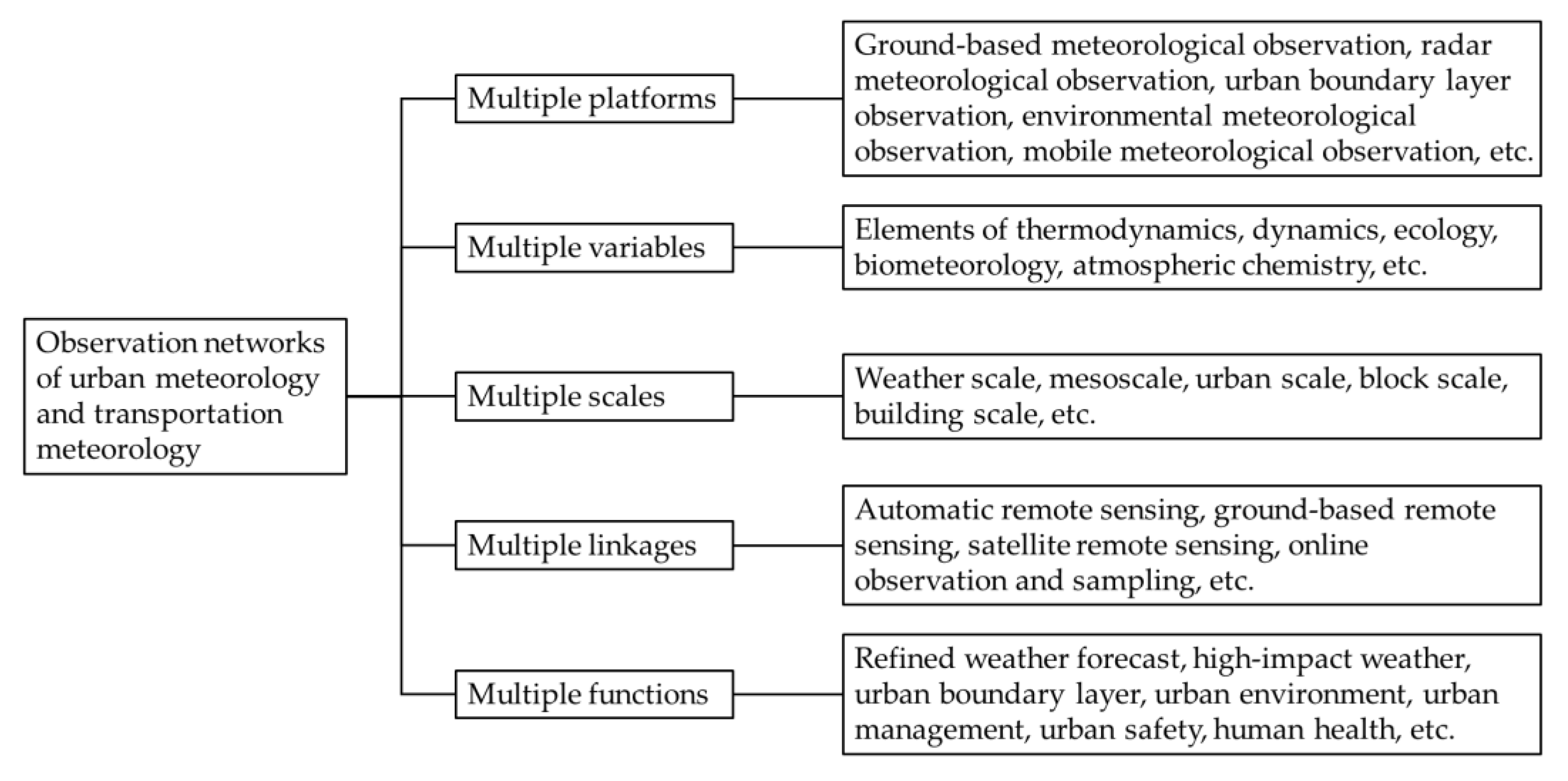
Figure 1. Characteristics and development directions of urban transportation meteorological observation network.
2. Urban Meteorological Outfield Observation Experiments
From the end of the last century to the beginning of this century, a series of large-scale outfield observation experiments have been successfully explored throughout the world, focusing on plenty of topics, among which the urban boundary layer meteorology and urban air pollution are two important and popular aspects [32]. In Beijing, China, the Beijing City Atmospheric Pollution Observation Field Experiment (BECAPEX, 2001–2003) and the Beijing Urban Boundary Layer Experiment (BUBLEX, 2004–2005) have been implemented to obtain three-dimensional structure integrated images of Beijing’s atmospheric dynamics and chemical process [33]. More details have also been included, such as urban observations of the boundary layer, rainstorm adaptability, complex terrain and atmospheric circulation, flux and energy balance, as well as the urban thermal environment [34]. Associated studies have revealed that the air pollution in Beijing usually comes from local sources, but the sources in the vicinity also have a prominent influence [35]. Nanjing City has also carried out several experiments (e.g., periods in 2004 and 2006) with urban boundary layer observations to investigate the urban mixed layer, convective entrainment zone, and cloud feedback processes via LIDAR (Light Detection and Ranging), radiosonde, meteorological towers, turbulence measurements, and many other techniques [36][37][38], based on which the transition features of the mixed layer and the entrainment zone over Nanjing City have been revealed by comparison between urban and suburban areas. During the past decade, the urban meteorological observation experiments have been mainly focused on the research of high-impact weather mechanisms and their mitigation countermeasures, on the urban effects on weather and climate, and on the mutual feedback between urban aerosols and weather climate [39]. Meanwhile, the observation scope has been expanded from a single city in the past to multiple cities (city clusters and metropolitan areas) nowadays. These investigations could assist cities in facing, detecting, and discussing hazards such as storm surges, flooding, heatwaves, and air pollution episodes, especially in the changing climate.
There are also downscaling outfield experiments conducted. For instance, Sun Yat-sen University carried out an urban climate experiment in 2016–2017 in the suburbs of Guangzhou on a reduced scale [40]. The experimental site covered an area of 4800 m2, which was far from surrounding buildings and had an impermeable surface. Two ideal street valley models were composed of roughly 2000 concrete building models, each with a height of 1.2 m, a width of 0.5 m, and a wall thickness of 1.5 cm. The effects of building heat capacities and street aspect ratios on the turbulence and temperature spatiotemporal characteristics of two-dimensional street valleys were investigated through outfield experiments under the typical non-stationary real meteorological conditions.
Moreover, through these outfield experiments on urban and transportation meteorology, the associated air pollution and source emission regarding PM2.5, CO, SO2, O3, and even various heavy metals were also analyzed to investigate their spatial and temporal distributions and developing trends [41][42]. Studies have also revealed that, in winter, volatile organic compounds (VOCs) including benzene, toluene, ethylbenzene, and xylene (BTEX) could mainly be attributed to urban transportation, posing hazards for human health [43][44]. At the same time, corresponding assessments of health risks related to human exposure to urban transportation pollution and emissions are also currently under investigation using the databases from multiple experiments [45][46].
3. Urban Transportation Meteorological Monitoring System
Since the 1980s, the Standing International Road Weather Commission (SIRWEC) has been established worldwide by several countries to carry out studies on winter road weather predictions, winter road treatment methods, the Road Weather Information System (RWIS), and the Intelligent Transportation System (ITS). The frequent information exchange and technology sharing among members have promoted the development of urban transportation meteorology to a great extent in various countries [47].
In China, transportation meteorological monitoring mainly started in 2005, which is relatively late compared to developed countries [48]. At the early stage, it mostly focused on the highways outside of cities, while less attention has been paid to urban transportation [49][50]. At present, meteorological monitoring along urban transportation lines is being vigorously developed, and automatic meteorological monitoring stations have been deployed along the major roads. However, such monitoring equipment arrangements are still not sufficient; they are unevenly distributed, with little coverage in many provinces, especially in mountainous areas [51]. There is currently an urgent requirement to further increase and construct urban transportation meteorological stations [52].
In addition, remote sensing techniques have been widely used and have allowed effective progress in urban transportation meteorological monitoring applications due to the improvement in quantification precision, wide monitoring range, fast update time, and relatively low cost [53]. For instance, the unmanned aerial vehicle for remote sensing has such advantages as real-time measurement (wireless communication transmission), flexibility (fixed or mobile stations), high resolution (horizontally 3–5 m and vertically ~1 m), cost-effectiveness, etc., and can gather information in dangerous environments without any risk to flight crews, providing a powerful supplement for spaceborne remote sensing and airborne remote sensing [54]. Such technology has been increasingly used in obtaining spatial data, e.g., the conventional meteorological elements and urban transportation flow [55][56]. These improvements provide fundamental support for the implementation of the real-time monitoring of roads [57].
On the other hand, the usage of Internet of Things technology, which transmits data among multiple pieces of equipment via the internet in near-real time, provides an effective channel for the combination of meteorological information and urban transportation derived from multiple sensors [58][59][60]. By means of the automatic and timely communication between different equipment, it has generally realized the construction of urban transportation meteorological monitoring frameworks and plays a crucial role in the business operation of transportation management and emergency management [61][62]. Taking the Beijing Municipal Commission of Transportation as an example, based on the project titled “The internet of things application demonstration project of maintaining road traffic unblocked in extreme meteorological conditions”, under the framework of the first batch of Internet of Things projects in Beijing, the meteorological information obtained by meteorological sensors is combined with transportation information, with schemes of prediction and early warning proposed regarding the depth of waterlogging, snow cover, ice formation, visibility, and others [63]. It has been successfully attempted and plays an important role in road transportation management under complex weather conditions [64]. Moreover, the Wuxi Meteorological Bureau of Jiangsu Province has also deployed Internet of Things-based urban waterlogging monitoring stations at some specific locations on main traffic roads [65]. Subsequently, a system of urban waterlogging monitoring and early warning has been constructed, realizing the automated, digitalized, and refined real-time online management of urban transportation meteorological conditions, especially the waterlogging risk [66].
With respect to rail-based urban transportation, based on sufficient experience in event prevention and emergency disposal, the Shanghai Urban Rail Transportation and Shanghai Meteorological Service Center jointly developed the Shanghai Rail Transportation Meteorological Assistant Decision-Making System in 2020, using the basic geographic data, observations, and monitoring information of local automatic weather stations within the Shanghai Meteorological Bureau. The real-time monitoring and risk warning of urban transportation meteorological disasters, as well as other functions, are therefore achieved [67]. In general, the system mainly consists of six main sections: a central map, risk warning, weather forecasts, impact, early warning information, and extreme weather statistics. By adopting technologically advanced monitoring methods and obtaining timely and effective early warning information, the meteorological risks of rail-based urban transportation could be “moved forward”, building a solid foundation for improved operational urban rail transportation safety.
References
- Allwine, K.J.; Shinn, J.H.; Streit, G.E.; Clawson, K.L.; Brown, M. Overview of URBAN 2000. Bull. Am. Meteorol. Soc. 2002, 83, 521–536.
- Allwine, K.J.; Leach, M.J.; Stockham, L.W.; Shinn, J.S.; Hosker, R.P.; Bowers, J.F.; Pace, J.C. Overview of Joint Urban 2003: An atmospheric dispersion study in Oklahoma City. In Proceedings of the Symposium on Planning, Nowcasting, and Forecasting in the Urban Zone, Seattle, WA, USA, 10–15 January 2004.
- Warner, T.; Benda, P.; Swerdlin, S.; Knievel, J.; Argenta, E.; Aronian, B.; Balsley, B.; Bowers, J.; Carter, R.; Clark, P.; et al. The Pentagon Shield Field Program: Toward Critical Infrastructure Protection. Bull. Am. Meteorol. Soc. 2007, 88, 167–176.
- Hanna, S.; White, J.; Zhou, Y.; Kosheleva, A. Analysis of Joint Urban 2003 (JU2003) and Madison Square Garden 2005 (MSG05) Meteorological and Tracer Data. In Proceedings of the 6th Symposium on the Urban Environment, Atlanta, GA, USA, 27 January–3 February 2006.
- Orville, R.; Zhang, R.; Nielsen-Gammon, J.; Collins, D.; Ely, B.; Steiger, S. Houston Environmental Aerosol Thunderstorm (HEAT) Project; Texas A&M University Department of Atmospheric Sciences: College Station, TX, USA, 2004; p. 57.
- Cros, B.; Durand, P.; Cachier, H.; Drobinski, P.; Fréjafon, E.; Kottmeier, C.; Perros, P.; Peuch, V.-H.; Ponche, J.-L.; Robin, D.; et al. The ESCOMPTE program: An overview. Atmos. Res. 2004, 69, 241–279.
- Masson, V.; Gomes, L.; Pigeon, G.; Liousse, C.; Pont, V.; Lagouarde, J.P.; Voogt, J.; Salmond, J.; Oke, T.R.; Hidalgo, J.; et al. The Canopy and Aerosol Particles Interactions in TOulouse Urban Layer (CAPITOUL) experiment. Meteorol. Atmos. Phys. 2008, 102, 135.
- Arnold, S.; ApSimon, H.; Barlow, J.; Belcher, S.; Bell, M.; Boddy, J.; Britter, R.; Cheng, H.; Clark, R.; Colvile, R.; et al. Introduction to the DAPPLE Air Pollution Project. Sci. Total Environ. 2004, 332, 139–153.
- Harrison, R.M.; Dall’Osto, M.; Beddows, D.C.S.; Thorpe, A.J.; Bloss, W.J.; Allan, J.D.; Coe, H.; Dorsey, J.R.; Gallagher, M.; Martin, C.; et al. Atmospheric chemistry and physics in the atmosphere of a developed megacity (London): An overview of the REPARTEE experiment and its conclusions. Atmos. Chem. Phys. 2012, 12, 3065–3114.
- Bohnenstengel, S.I.; Belcher, S.E.; Aiken, A.; Allan, J.D.; Allen, G.; Bacak, A.; Bannan, T.J.; Barlow, J.F.; Beddows, D.C.S.; Bloss, W.J.; et al. Meteorology, Air Quality, and Health in London: The ClearfLo Project. Bull. Am. Meteorol. Soc. 2015, 96, 779–804.
- Rotach, M.W.; Vogt, R.; Bernhofer, C.; Batchvarova, E.; Christen, A.; Clappier, A.; Feddersen, B.; Gryning, S.-E.; Martucci, G.; Mayer, H.; et al. BUBBLE—An urban boundary layer meteorology project. Arch. Meteorol. Geophys. Bioclimatol. Ser. B 2005, 81, 231–261.
- Nakatani, T.; Misumi, R.; Shoji, Y.; Saito, K.; Seko, H.; Seino, N.; Suzuki, S.-I.; Shusse, Y.; Maesaka, T.; Sugawara, H. Tokyo metropolitan area convection study for extreme weather resilient cities. Bull. Am. Meteorol. Soc. 2015, 96, ES123–ES126.
- Hicks, B.B.; Callahan, W.J.; Pendergrass, W.R., III; Dobosy, R.J.; Novakovskaia, E. Urban turbulence in space and in time. J. Appl. Meteorol. Climatol. 2012, 51, 205–218.
- Koskinen, J.T.; Poutiainen, J.; Schultz, D.M.; Joffre, S.; Koistinen, J.; Saltikoff, E.; Gregow, E.; Turtiainen, H.; Dabberdt, W.F.; Damski, J.; et al. The Helsinki Testbed: A mesoscale measurement, research, and service platform. Bull. Am. Meteorol. Soc. 2011, 92, 325–342.
- Takahashi, K.; Mikami, T.; Takahashi, H. Influence of the urban heat island phenomenon in Tokyo in land and sea breezes. In Proceedings of the Seventh International Conference on Urban Climate, Yokohama, Japan, 29 June–3 July 2009.
- Tan, J.; Yang, L.; Grimmond, C.S.B.; Shi, J.; Gu, W.; Chang, Y.; Hu, P.; Sun, J.; Ao, X.; Han, Z. Urban integrated meteorological observations: Practice and experience in Shanghai, China. Bull. Am. Meteorol. Soc. 2015, 96, 85–102.
- Miao, S.; Jiang, W.; Liang, P.; Liu, H.; Wang, X.; Tan, J.; Zhang, N.; Li, J.; Du, W.; Pei, L. Advances in urban meteorological research in China. J. Meteorol. Res. 2020, 34, 218–242.
- Yu, M.; Dou, J.; Miao, S.; Chu, Y.; Sun, D. Advances of urban meteorological research: International conference on urban climate. Adv. Meteorol. Sci. Technol. 2019, 9, 16–22.
- Liang, X.; Miao, S.; Li, J.; Bornstein, R.; Zhang, X.; Gao, Y.; Chen, F.; Cao, X.; Cheng, Z.; Clements, C.; et al. SURF: Understanding and Predicting Urban Convection and Haze. Bull. Am. Meteorol. Soc. 2018, 99, 1391–1413.
- Sun, J.; Mahrt, L.; Banta, R.M.; Pichugina, Y.L. Turbulence regimes and turbulence intermittency in the stable boundary layer during CASES-99. J. Atmos. Sci. 2012, 69, 338–351.
- Sun, J.; Lenschow, D.H.; LeMone, M.A.; Mahrt, L. The role of large-coherent-eddy transport in the atmospheric surface layer based on CASES-99 Observations. Boundary-Layer Meteorol. 2016, 160, 83–111.
- Zhu, Y.; Liu, H.; Shen, J.; Ji, Y. Influence of urban heat island on pollution diffusion in Suzhou. Plateau Meteorol. 2016, 35, 1584–1594.
- Liu, H.; Ma, W.; Qian, J.; Cai, J.; Ye, X.; Li, J.; Wang, X. Effect of urbanization on the urban meteorology and air pollution in Hangzhou. J. Meteorol. Res. 2015, 29, 950–965.
- Mao, X.; Jiang, Y.; Zhuang, H.; Rao, H.; Tan, M. A brief introduction to Shenzhen urban meteorological observing network of networks. Adv. Meteorol. Sci. Technol. 2013, 3, 13–18.
- Hu, F.; Li, X.; Chen, H.; Liu, G. Turbulence characteristics in the rough urban canopy layer. Clim. Environ. Res. 1999, 3, 252–258.
- Miao, S.; Dou, J.; Chen, F.; Li, J.; Li, A. Analysis of observations on the urban surface energy balance in Beijing. Sci. China Earth Sci. 2012, 55, 1881–1890.
- Li, L.; Lu, C.; Chan, P.-W.; Zhang, X.; Yang, H.-L.; Lan, Z.-J.; Zhang, W.-H.; Liu, Y.-W.; Pan, L.; Zhang, L. Tower observed vertical distribution of PM2.5, O3 and NOx in the Pearl River Delta. Atmos. Environ. 2019, 220, 117083.
- Miao, S.; Chen, F. Enhanced modeling of latent heat flux from urban surfaces in the Noah/single-layer urban canopy coupled model. Sci. China Earth Sci. 2014, 57, 2408–2416.
- Huang, H.; Li, Y.; Han, S.; Wu, B.; Zhang, Y.; Li, C. Turbulent statistic characteristic of the urban boundary layer in Tianjin. Plateau Meteorol. 2011, 30, 1481–1487.
- Liang, Y.; Wu, C.; Wu, D.; Liu, B.; Li, Y.J.; Sun, J.; Yang, H.; Mao, X.; Tan, J.; Xia, R.; et al. Vertical distributions of atmospheric black carbon in dry and wet seasons observed at a 356-m meteorological tower in Shenzhen, South China. Sci. Total Environ. 2022, 853, 158657.
- Wang, Z.; Zhang, X.; Mao, J.; Ji, C. Overview of ground-based remote sensing observation techniques for air temperature, humidity and wind profiles. Meteorol. Hydrol. Mar. Instrum. 2018, 35, 109–116.
- Grimmond, C.S.B. Progress in measuring and observing the urban atmosphere. Theor. Appl. Climatol. 2006, 84, 3–22.
- Xu, X.; Ding, G.; Bian, L.; Xie, L. Characteristics of atmospheric environment of boundary layer structure of city community in BECAPEX and integrate influence. Acta Meteorol. Sin. 2004, 5, 663–671.
- Li, J.; Shu, W. Observation and analysis of nocturnal low-level jet characteristics over Beijing in summer. Chin. J. Geophys. 2008, 51, 360–368.
- Li, J.; Dou, J. Progress in urban meteorological experiments in Beijing. Adv. Meteorol. Sci. Technol. 2014, 4, 36–45.
- Liu, H.; Jiang, W.; Sun, J.; Liu, G. An observation and analysis of the micrometeorological characteristics of the Nanjing urban boundary layer, eastern China. J. Nanjing Univ. (Nat. Sci.) 2008, 1, 99–106.
- Mao, M.; Jiang, W.; Wu, X.; Qi, F.; Yuan, R.; Fang, H.; Liu, D.; Zhou, J. LIDAR exploring of the UBL in downtown of the Nanjing City. Acta Sci. Circumstantiae 2006, 26, 1723–1728.
- Mao, M.; Jiang, W.; Gu, J.; Xie, C.; Zhou, J. Study on the mixed layer, entrainment zone, and cloud feedback based on lidar exploration of Nanjing city. Geophys. Res. Lett. 2009, 36.
- Baklanov, A.; Grimmond, C.; Carlson, D.; Terblanche, D.; Tang, X.; Bouchet, V.; Lee, B.; Langendijk, G.; Kolli, R.; Hovsepyan, A. From urban meteorology, climate and environment research to integrated city services. Urban Clim. 2018, 23, 330–341.
- Chen, G.; Wang, D.; Wang, Q.; Li, Y.; Wang, X.; Hang, J.; Gao, P.; Ou, C.; Wang, K. Scaled outdoor experimental studies of urban thermal environment in street canyon models with various aspect ratios and thermal storage. Sci. Total Environ. 2020, 726, 138147.
- Hajizadeh, Y.; Jafari, N.; Fanaei, F.; Ghanbari, R.; Mohammadi, A.; Behnami, A.; Jafari, A.; Aghababayi, M.; Abdolahnejad, A. Spatial patterns and temporal variations of traffic-related air pollutants and estimating its health effects in Isfahan city, Iran. J. Environ. Health Sci. Eng. 2021, 19, 781–791.
- Soleimani, A.; Toolabi, A.; Mansour, S.N.; Abdolahnejad, A.; Akther, T.; Fouladi-Fard, R.; Miri, M.; Mohammadi, A. Health risk assessment and spatial trend of metals in settled dust of surrounding areas of Lake Urmia, NW Iran. Int. J. Environ. Anal. Chem. 2022, 1–14.
- Mojarrad, H.; Fard, R.F.; Rezaali, M.; Heidari, H.; Izanloo, H.; Mohammadbeigi, A.; Mohammadi, A.; Sorooshian, A. Spatial trends, health risk assessment and ozone formation potential linked to BTEX. Hum. Ecol. Risk Assess. Int. J. 2019, 26, 2836–2857.
- Wang, Y.; Bai, Y.; Zhi, X.; Wu, K.; Zhao, T.; Zhou, Y.; Xiong, J.; Zhu, S.; Zhou, W.; Hu, W.; et al. Two typical patterns of regional PM2.5 transport for heavy air pollution over Central China: Rapid transit transport and stationary accumulation transport. Front. Environ. Sci. 2022.
- Mokhtari, M.; Jafari, N.; Mohammadi, A.; Hajizadeh, Y.; Ghanbari, R.; Nemati, S.; Abdolahnejad, A. Temporal and spatial trends of airborne asbestos fiber concentrations in the urban areas of Yazd, Iran. Int. J. Environ. Sci. Technol. 2018, 16, 2657–2666.
- Faraji, M.; Mohammadi, A.; Najmi, M.; Fallahnezhad, M.; Sabetkish, N.; Kazemnejad, A.; Shoormasti, R.S.; Fazlollahi, M.R.; Pourpak, Z.; Moin, M. Exposure to ambient air pollution and prevalence of asthma in adults. Air Qual. Atmos. Health 2021, 14, 1211–1219.
- Tian, H.; Zhang, N.; Zhang, K.; Yang, J.; Zhang, H. Advance on highway traffic meteorological research in foreign country. J. Meteorol. Environ. 2019, 35, 79–86.
- Zhang, C.; Zhang, L.; Cheng, C.; Wang, B. Advances in road weather forecasting system and its future development. J. Trop. Meteorol. 2007, 23, 652–658.
- Hu, J.; Lin, Z.; Cheng, T. Research progress on temperature prediction method for road icing. Sci. Technol. Eng. 2020, 20, 1–6.
- Telang, S.; Chel, A.; Nemade, A.; Kaushik, G. Intelligent Transport System for a Smart City. In Security and Privacy Applications for Smart City Development; Tamane, S.C., Dey, N., Hassanien, A.E., Eds.; Studies in Systems, Decision and Control; Springer: Cham, Switzerland, 2021; Volume 308.
- Lu, Z.; Liu, Z.; Li, Y.; Jia, A.; Ye, R. Research on highway traffic meteorological monitoring system. Meteorol. Hydrol. Mar. Instrum. 2021, 38, 16–19.
- Chu, Y. On the system of road traffic’s meteorological monitoring and early warning based on GIS. J. Liaoning Police Coll. 2017, 19, 58–62.
- Wang, L.; Li, X.; Bao, Y.; Shao, Y. Research progress of remote sensing application on transportation meteorological disasters. Remote Sens. Land Resour. 2018, 30, 1–7.
- Li, C.; Shen, L.; Wang, H.; Lei, T. The research on unmanned aerial vehicle remote sensing and its applications. In Proceedings of the 2nd International Conference on Advanced Computer Control, Shenyang, China, 27–29 March 2010; pp. 644–647.
- Whitehead, K.; Hugenholtz, C.H.; Myshak, S.; Brown, O.; LeClair, A.; Tamminga, A.; Barchyn, T.E.; Moorman, B.; Eaton, B. Remote sensing of the environment with small unmanned aircraft systems (UASs), part 1: A review of progress and challenges. J. Unmanned Veh. Syst. 2014, 2, 69–85.
- Whitehead, K.; Hugenholtz, C.H.; Myshak, S.; Brown, O.; LeClair, A.; Tamminga, A.; Barchyn, T.E.; Moorman, B.; Eaton, B. Remote sensing of the environment with small unmanned aircraft systems (UASs), part 2: Scientific and commercial applications. J. Unmanned Veh. Syst. 2014, 2, 86–102.
- Barmpounakis, E.N.; Vlahogianni, E.I.; Golias, J.C. Unmanned Aerial Aircraft Systems for transportation engineering: Current practice and future challenges. Int. J. Transp. Sci. Technol. 2016, 5, 111–122.
- Atzori, L.; Iera, A.; Morabito, G. The Internet of Things: A survey. Comput. Netw. 2010, 54, 2787–2805.
- Chapman, L.; Muller, C.L.; Young, D.T.; Warren, E.; Grimmond, S.; Cai, X.-M.; Ferranti, E. The Birmingham urban climate laboratory: An open meteorological test bed and challenges of the smart city. Bull. Am. Meteorol. Soc. 2015, 96, 1545–1560.
- Zhang, N.; Chen, H.; Chen, X.; Chen, J. Semantic framework of Internet of Things for smart cities: Case studies. Sensors 2016, 16, 1501.
- Liu, C.; Ke, L. Cloud assisted Internet of things intelligent transportation system and the traffic control system in the smart city. J. Control Decis. 2022, 1–14.
- Zhou, H.; Liu, B.; Wang, D. Design and research of urban intelligent transportation system based on the Internet of Things. In Internet of Things. Communications in Computer and Information Science; Wang, Y., Zhang, X., Eds.; Springer: Berlin/Heidelberg, Germany, 2012; Volume 312, pp. 572–580.
- The People’s Government of Beijing Municipality. Overall Plan for Internet of Things Application Construction in Beijing’s Urban Safe Operation and Emergency Management; Beijing Government General Office: Beijing, China, 2011; p. 14.
- Beijing Municipal Commission of Transportation. The Feasibility Study of “The Internet of Things Application Demonstration Project of Maintaining Road Traffic Unblocked in Extreme Meteorological Conditions”; Beijing Municipal Commission of Transportation: Beijing, China, 2011; pp. 127–130.
- Zhi, X.; Cui, B.; Ji, Y.; Zhu, S.; Ma, Z.; Zhang, X. Prediction of water level in urban waterlogging area based on deep learning approach. In Proceedings of the International Conference on Electrocommunication, Intelligent Computing and Systems, Xi’an, China, 18–19 June 2022.
- Zhang, X.; Sun, H.; Zhang, L. Discussion on locations of road weather information system station on smart expressway. Highway 2022, 67, 248–254.
- Geng, K. Strategy for refined control of meteorological risks in Shanghai urban rail transit. Urban Mass Transit. 2022, 25, 86–90.
More
Information
Subjects:
Meteorology & Atmospheric Sciences
Contributors
MDPI registered users' name will be linked to their SciProfiles pages. To register with us, please refer to https://encyclopedia.pub/register
:
View Times:
871
Revisions:
4 times
(View History)
Update Date:
25 Nov 2022
Table of Contents


Notice
You are not a member of the advisory board for this topic. If you want to update advisory board member profile, please contact office@encyclopedia.pub.
OK
Confirm
Only members of the Encyclopedia advisory board for this topic are allowed to note entries. Would you like to become an advisory board member of the Encyclopedia?
Yes
No
${ textCharacter }/${ maxCharacter }
Submit
Cancel
Back
Comments
${ item }
|
${ item.createdUser.fullName }
${ item.createdAt }
${ item.vote }
${ item.reply }
Delete
${ reply.createdUser.fullName }
${ reply.createdAt }
${ reply.vote }
Delete
There is no reply to this comment~
${ item.replyTextCharacter }/${ item.replyMaxCharacter }
Submit
Cancel
More
No more~
There is no comment~
${ textCharacter }/${ maxCharacter }
Submit
Cancel
${ selectedItem.replyTextCharacter }/${ selectedItem.replyMaxCharacter }
Submit
Cancel
Confirm
Are you sure to Delete?
Yes
No