 +1 credit
| Version | Summary | Created by | Modification | Content Size | Created at | Operation |
|---|---|---|---|---|---|---|
| 1 | Dean Liu | -- | 5161 | 2022-09-30 01:44:29 |
Video Upload Options
This is a list of extreme points of Earth, the geographical locations that are farther north or south than, higher or lower in elevation than, or farthest inland or out to sea from, any other locations on the landmasses, continents or countries. For other lists of extreme points on Earth, including places that hold temperature and weather records, see Extremes on Earth, Lists of extreme points, and List of weather records.
1. Earth
1.1. Latitude and Longitude
- The northernmost point on Earth is the Geographic North Pole, in the Arctic Ocean.
- The northernmost point on land is the northern tip of Kaffeklubben Island, north of Greenland (83°40′N 29°50′W / 83.667°N 29.833°W / 83.667; -29.833 (northernmost point on land)), which lies slightly north of Cape Morris Jesup, Greenland (83°38′N 32°40′W / 83.633°N 32.667°W / 83.633; -32.667 (Cape Morris Jesup)). Various shifting gravel bars lie farther north, the most famous being Oodaaq. There has been other islands more northern such as 83-42 and ATOW1996 but they are not confirmed as permanent.
- The southernmost point on Earth and the southernmost point on land is the geographic South Pole, which is on the continent of Antarctica.
- The southernmost point of water is a bay on the Filchner-Ronne Ice Shelf along the coast of Antarctica (83°S 59°W / 83°S 59°W / -83; -59) about 100 km (62 mi) south of Berkner Island, the southernmost island in the world. The southernmost point of ocean is located on the Gould Coast (84°30′S 150°0′W / 84.5°S 150°W / -84.5; -150 (southernmost point of ocean));[1] the southernmost point of open ocean is also part of the Ross Sea, namely the Bay of Whales at 78°30'S, at the edge of the Ross Ice Shelf.[2]
- The westernmost and easternmost points on Earth, based on the east–west standard for describing longitude, can be found anywhere along the 180th meridian in Siberia (including Wrangel Island), Antarctica, or the three islands of Fiji through which the 180th meridian passes (Vanua Levu's eastern peninsula, the middle of Taveuni, and the western part of Rabi Island).
- Using the path of the International Date Line, the westernmost point on land is Attu Island, Alaska, and the easternmost point on land is Caroline Island, Kiribati.[3]
1.2. Elevation
Highest points
- The highest point on Earth's surface measured from sea level is the summit of Mount Everest on the border of Nepal and China . While measurements of its height vary slightly, the elevation of its peak is usually given as 8,848 m (29,029 ft) above sea level. It was first reached by Sir Edmund Hillary of New Zealand and Sherpa of Nepal Tenzing Norgay in 1953.
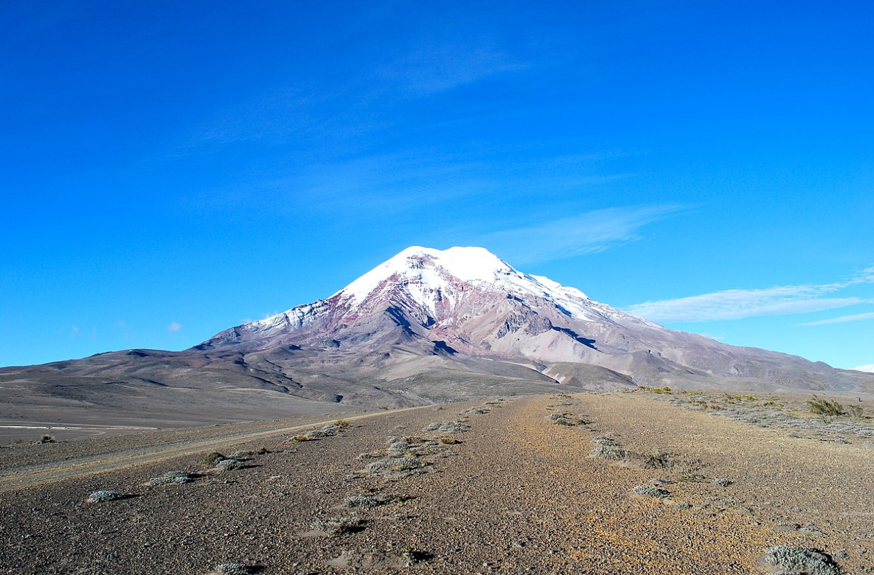
- The point farthest from Earth's centre is the summit of Chimborazo[4] in Ecuador, at 6,384.4 km (3,967.1 mi) from Earth's centre; the peak's elevation relative to sea level is 6,263.47 m (20,549 ft).[5] This is because Earth is an oblate spheroid rather than a perfect sphere; it is wider at the Equator and narrower between the poles. Therefore, the summit of Chimborazo, which is near the Equator, is farther away from Earth's centre than the summit of Mount Everest is; the latter is 2,168 m (7,112.9 ft) closer, at 6,382.3 km (3,965.8 mi) from Earth's centre. Peru's Huascarán (at 6,768 m or 22,205 ft) contends closely with Chimborazo, the difference in the mountains' heights being just 23 m (75 ft).
- The fastest point on Earth or, in other words, the point furthest from the axis of Earth is the summit of Cayambe[6] in Ecuador, at 1,675.89 km/h (1,041.35 mph) and 6,383.95 km (3,966.80 mi) from the axis. Like Chimborazo, which is the fourth fastest peak at 1,675.47 km/h (1,041.09 mph), it is close to the Equator and takes advantage of the oblate spheroid figure of Earth. More importantly, however, it being so near the Equator means that the majority of its distance from Earth's centre goes into it being away from the axis. The importance of latitude becomes most apparent when one looks at the Challenger Deep (speed of 1,639.15 km/h or 1,018.52 mph) compared to Mount Everest (speed of 1,481.67 km/h or 920.67 mph).
Highest points attainable by transportation
- The highest point accessible...
- ...by land vehicle is an elevation of 6,688 m (21,942 ft) on Ojos del Salado in Chile , which was reached by the Chilean duo of Gonzalo and Eduardo Canales Moya on 21 April 2007 with a modified Suzuki Samurai, setting the high-altitude record for a four-wheeled vehicle.
- ...by road (dead end) is on a mining road to the summit of Aucanquilcha in Chile , which reaches an elevation of 6,176 m (20,262 ft). It was once usable by 20-tonne mining trucks.[7] The road is no longer usable. 21°12′50″S 68°28′30″W / 21.214°S 68.475°W / -21.214; -68.475
- ...by road (mountain pass) is disputed; there are a number of competing claims for this title due to the definition of "motorable pass" (i.e. a surfaced road or one simply passable by a vehicle):
- The highest asphalted road crosses Tibet's Semo La pass at 5,565 m (18,258 ft). It is used by trucks and buses regularly.[8] The Ticlio pass, on the Central Road of Peru, is the highest surfaced road in the Americas, at an elevation of 4,818 m (15,807 ft).
- The highest unsurfaced road is claimed by several different roads. All are unsurfaced or gravel roads including the barely passable road to Umling, LA, 17 km (11 mi) west of Demchok in Ladakh, India , which reaches 5,800 m (19,029 ft) ("19,300 feet" according to a Border Roads Organisation sign there that recognizes it as the "World's Highest Motorable Pass"),[9] and Mana Pass, between India and Tibet, which is crossed by a gravel road reaching 5,610 m (18,406 ft). The heavily trafficked Khardung La in Ladakh lies at 5,359 m (17,582 ft). A possibly motorable gravel road crosses Marsimik La in Ladakh at 5,582 m (18,314 ft).
- ...by train is Tanggula Pass, located on the Qinghai–Tibet (Qingzang) Railway in the Tanggula Mountains of Qinghai/Tibet, China , at 5,072 m (16,640 ft). The Tanggula railway station is the world's highest railway station at 5,068 m (16,627 ft). Before the Qingzang Railway was built, the highest railway ran between Lima and Huancayo in Peru, reaching 4,829 m (15,843 ft) at Ticlio.[10]
- ...by oceangoing vessel is a segment of the Rhine–Main–Danube Canal between the Hilpoltstein and Bachhausen locks in Bavaria, Germany. The locks artificially raise the surface level of the water in the canal to 406 m (1,332 ft) above mean sea level, higher than any other lock system in the world, making it the highest point currently accessible by oceangoing commercial watercraft.
- The highest commercial airport is Daocheng Yading Airport, Sichuan, China, at 4,411 m (14,472 ft).[11] The proposed Nagqu Dagring Airport in Tibet, if built, will be 25 m (82 ft) higher at 4,436 m (14,554 ft).
- The highest helipad is Sonam, Siachen Glacier, India, at a height of 6,400 m (20,997 ft) above sea level.[12]
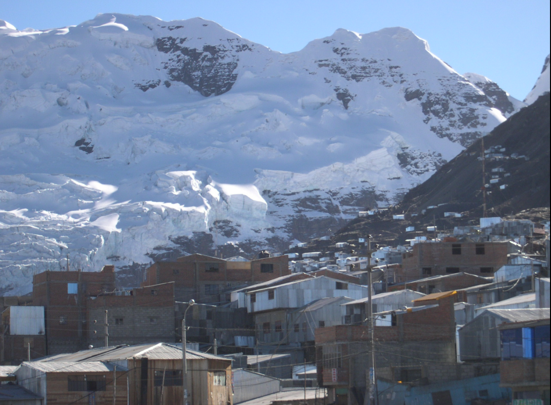
- The highest permanent human settlement is La Rinconada, Peru, 5,100 m (16,732 ft), in the Peruvian Andes.
- The farthest road from the Earth's centre is the Road to Carrel Hut in the Ecuadorian Andes, at an elevation of 4,850 m (15,912 ft) above sea level and a distance of 6,382.9 km (3,966 mi) from the centre of the Earth.[13]
Highest geographical features
- The highest volcano is Ojos del Salado on the Argentina–Chile border. It has the highest summit, 6,893 m (22,615 ft), of any volcano on Earth.
- The highest natural lake is an unnamed crater lake on Ojos del Salado at 6,390 m (20,965 ft),[14] on the Argentina side. Another candidate was Lhagba Pool on the northeast slopes of Mount Everest, Tibet, at an elevation of 6,368 m (20,892 ft), which has since dried up.[15]
- The highest navigable lake is Lake Titicaca, on the border of Bolivia and Peru in the Andes, at 3,812 m (12,507 ft).
- The highest glacier is the Khumbu Glacier on the southwest slopes of Mount Everest in Nepal, beginning on the west side of Lhotse at an elevation of 7,600 to 8,000 m (24,900 to 26,200 ft).[16]
- The highest river is disputed; one candidate from many possibilities is the Ating Ho, which flows into the Aong Tso (Hagung Tso), a large lake in Tibet, and has an elevation of about 6,100 m (20,013 ft) at its source at 32°49′30″N 81°03′45″E / 32.825°N 81.0625°E / 32.825; 81.0625 (Ating Ho (source)). A very large and high river is the Yarlung Tsangpo or upper Brahmaputra River in Tibet, whose main stem, the Maquan River, has its source at about 6,020 m (19,751 ft) above sea level at 30°48′59″N 82°42′45″E / 30.81639°N 82.7125°E / 30.81639; 82.7125 (Maquan River (source)).[17] Above these elevations, there are no constantly flowing rivers since the temperature is almost always below freezing.
- The highest island is one of a number of islands in the Orba Co lake in Tibet, at an elevation of 5,209 m (17,090 ft).[18]
Lowest points
Lowest artificial points
- The lowest point underground ever reached was 12,262 m (40,230 ft) deep (SG-3 at the Kola Superdeep Borehole).
- The lowest human-sized point underground is 3,900 m (12,800 ft)[19] below ground at the TauTona Mine, Carletonville, South Africa.
- The lowest (from sea level) artificially made point with open sky may be the Hambach surface mine, Germany, which reaches a depth of 293 m (961 ft) below sea level.
- The lowest (from surface) artificially made point with open sky may be the Bingham Canyon open-pit mine, Salt Lake City, United States, at a depth of 1,200 m (3,900 ft) below surface level.
- The lowest point underwater is the 10,685 m (35,056 ft)-deep (as measured from the subsea wellhead) oil and gas well drilled on the Tiber Oil Field in the Gulf of Mexico. The wellhead of this well was an additional 1,259 m (4,131 ft) underwater for a total distance of 11,944 m (39,186 ft) as measured from sea level.[20]28°44′12″N 88°23′13″W / 28.736667°N 88.386944°W / 28.736667; -88.386944
Lowest natural points
- The lowest known point is Challenger Deep, at the bottom of the Mariana Trench, 11,034 m (36,201 ft) below sea level.[21] Only six humans have reached the bottom of the trench: Jacques Piccard and U.S. Navy Lieutenant Don Walsh in 1960 aboard the bathyscaphe Trieste, filmmaker James Cameron in 2012 aboard Deepsea Challenger, as well as Victor Vescovo, Patrick Lahey, and Jonathan Struwe aboard the DSV Limiting Factor in 2019.[22]
- The lowest point underground is more than 2,000 m (6,600 ft) under the Earth's surface. For example, the altitude difference between the entrance and the deepest explored point (the maximum depth) of the Krubera Cave in Georgia is 2,191 ± 20 m (7,188 ± 66 ft). In 2012, Ukrainian cave diver Gennadiy Samokhin reached the lowest point, breaking the world record.[23]
- The lowest point on land not covered by liquid water is the canyon under Denman Glacier, with the bedrock being 3,500 m (11,500 ft) below sea level.[24][25]
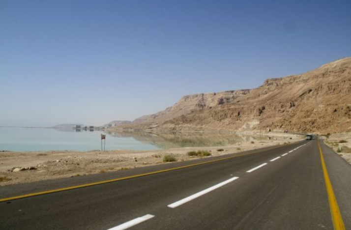
- The lowest point on dry land is the shore of the Dead Sea, shared by Israel, Palestine, and Jordan, 432.65 m (1,419 ft) below sea level. As the Dead Sea waters are receding, the water surface level drops more than 1 m per year.[26]
- The point on the surface closest to the Earth's centre (interpreted as a natural surface of the land or sea that is accessible by a person) is the surface of the Arctic Ocean at the Geographic North Pole (6,356.77 km or 3,950 mi).
- The closest point on the ground (interpreted as a land surface or sea floor) is the bottom of the Litke Deep, which is 6,351.61 km (3,947 mi) from the centre of the Earth. By comparison, the bottom of the deepest oceanic trench in the world, the Mariana Trench in the Pacific Ocean, is 14.7 km (9 mi) farther from the centre of the Earth.
Lowest points attainable by transportation
- The lowest point accessible...
- ...by road, excluding roads in mines, is any of the roads alongside the Dead Sea in Israel and Jordan, which are the lowest on Earth at 418 m (1,371 ft) below sea level.
- The lowest undersea highway tunnel is the Eiksund Tunnel, in Norway , at 287 m (942 ft) below sea level.
- ...by train, excluding the tracks inside some South Africa n gold mines, which can be several thousand metres below sea level, is located in the Seikan Tunnel of Japan railroad, at 240 m (787 ft) below sea level. For comparison, the undersea Channel Tunnel between England and France reaches a depth of 75 m (246 ft) below sea level.
- ...by road, excluding roads in mines, is any of the roads alongside the Dead Sea in Israel and Jordan, which are the lowest on Earth at 418 m (1,371 ft) below sea level.
The lowest railroad station was the Japanese Yoshioka-Kaitei Station, at 150 m (492 ft) below sea level, but it was closed in 2014. The lowest railroad not inside a tunnel is 120 m (394 ft) below sea level, at Beit She'an railway station in Israel.
- The lowest airfield is the Bar Yehuda Airfield, near Masada, Israel, at 378 m (1,240 ft) below sea level.
- The lowest commercial airport is Atyrau Airport, near Atyrau, Kazakhstan, at 22 m (72 ft) below sea level, in the basin of the Caspian Sea.
Lowest cities
Baku, Azerbaijan is located 28 m (92 ft) below sea level, which makes it the lowest-lying national capital in the world and also the largest city in the world located below sea level.
1.3. Remoteness
Poles of inaccessibility
Each continent has its own continental pole of inaccessibility, defined as the place on the continent that is farthest from any ocean. Similarly, each ocean has its own oceanic pole of inaccessibility, defined as the place in the ocean that is farthest from any land.
Continental
- The most distant point from an ocean is the Eurasian Pole of Inaccessibility (or "EPIA") 46°17′N 86°40′E / 46.283°N 86.667°E / 46.283; 86.667 (Continental Pole of Inaccessibility), in China 's Xinjiang region near the border with Kazakhstan. Calculations have shown that this point, located in the Dzoosotoyn Elisen Desert, is 2,645 km (1,644 mi) from the nearest coastline. The nearest settlement to the EPIA is Suluk at 46°15′N 86°50′E / 46.25°N 86.833°E / 46.25; 86.833 (Suluk), about 11 km (6.8 mi) to the east. A 2007 study suggests that the historical calculation of the EPIA failed to recognize the point where the Gulf of Ob joins the Arctic Ocean, and proposes instead that varying definitions of coastline could result in other locations for the EPIA:
- EPIA1, somewhere between 44°17′N 82°11′E / 44.283°N 82.183°E / 44.283; 82.183 (EPIA1.1) and 44°29′N 82°19′E / 44.483°N 82.317°E / 44.483; 82.317 (EPIA1.2), is about 2,510 ± 10 km (1,559.6 ± 6.2 mi) from the nearest ocean.
- EPIA2, somewhere between 45°17′N 88°08′E / 45.283°N 88.133°E / 45.283; 88.133 (EPIA2.1) and 45°28′N 88°14′E / 45.467°N 88.233°E / 45.467; 88.233 (EPIA2.2), is about 2,514 ± 7 km (1,562.1 ± 4.3 mi) from the nearest ocean.[27]
- If adopted, this would place the final EPIA roughly 130 km (81 mi) closer to the ocean than the point that is currently agreed upon.[27] Coincidentally, EPIA1, or EPIA2, and the most remote of the Oceanic Pole of Inaccessibility (specifically, the point in the South Pacific Ocean that is farthest from land) are similarly remote; EPIA1 is less than 200 km (120 mi) closer to the ocean than the Oceanic Pole of Inaccessibility is to land.
- The continental poles of inaccessibility for the other continents are as follows:
- Africa: 5°39′N 26°10′E / 5.65°N 26.17°E / 5.65; 26.17 (Continental Pole of Inaccessibility of Africa),[27] close to the tripoint of the Central African Republic, South Sudan, and the Democratic Republic of the Congo
- Australia: either 23°2′S 132°10′E / 23.033°S 132.167°E / -23.033; 132.167 (Australian Pole of Inaccessibility),[28] or 23°10′S 132°16′E / 23.17°S 132.27°E / -23.17; 132.27 (Continental Pole of Inaccessibility of Australia),[27] near Papunya, Northern Territory
- North America: 43°22′N 101°58′W / 43.36°N 101.97°W / 43.36; -101.97 (Pole of Inaccessibility North America),[27] between Kyle, South Dakota and Allen, South Dakota, United States .
- South America: 14°03′S 56°51′W / 14.05°S 56.85°W / -14.05; -56.85 (Continental Pole of Inaccessibility in South America),[27] near Arenápolis, Mato Grosso, Brazil
Oceanic
- The most distant point from land is the Pacific pole of inaccessibility (also called "Point Nemo"), which lies in the South Pacific Ocean at 48°52.6′S 123°23.6′W / 48.8767°S 123.3933°W / -48.8767; -123.3933 (Point Nemo), approximately 2,688 km (1,670 mi) from the nearest land (equidistant from Ducie Island in the Pitcairn Islands to the north, Motu Nui off Rapa Nui to the northeast, and Maher Island off Siple Island near Marie Byrd Land, Antarctica, to the south).[29]
Other places considered the most remote

- The most remote island is Bouvet Island, a small, uninhabited island in the South Atlantic Ocean that is a dependency of Norway . It lies at coordinates 54°26′S 3°24′E / 54.433°S 3.4°E / -54.433; 3.4 (most remote island). The nearest land is the uninhabited Queen Maud Land, Antarctica, over 1,600 km (994 mi) to the south. The nearest inhabited lands are Gough Island, 1,845 km (1,146 mi) away, Tristan da Cunha, 2,260 km (1,404 mi) away, and the coast of South Africa , 2,580 km (1,603 mi) away.
- The title for most remote inhabited island or archipelago (the farthest away from any other permanently inhabited place) depends on how the question is interpreted. If the south Atlantic island Tristan da Cunha (population about 300) and its dependency Gough Island (with a small staffed research post), which are 399 km (248 mi) from each other, are considered part of the same archipelago, or if Gough Island is not counted because it has no permanent residents, then Tristan da Cunha is the world's most remote inhabited island/archipelago: the main island, also called Tristan da Cunha, is 2,434 km (1,512 mi) from the island Saint Helena, 2,816 km (1,750 mi) from South Africa , and 3,360 km (2,090 mi) from South America. It is 2,260 km (1,404 mi) away from uninhabited Bouvet Island. However, if Gough and Tristan da Cunha are considered separately, they disqualify each other, and the most remote inhabited island is Easter Island in the South Pacific Ocean, which lies 2,075 km (1,289 mi) from Pitcairn Island (about 50 residents in 2013), 2,606 km (1,619 mi) from Rikitea on the island of Mangareva (the nearest town with a population over 500), and 3,512 km (2,182 mi) from the coast of Chile (the nearest continental point and the country of which Easter Island is part). The Kerguelen Islands in the southern Indian Ocean are another contender, lying 1,340 km (830 mi) from the small Alfred Faure scientific station in Île de la Possession, but otherwise more than 3,300 km (2,100 mi) from the coast of Madagascar (the nearest permanently inhabited place), 450 km (280 mi) northwest of the uninhabited Heard Island and McDonald Islands (both a part of Australia ), and 1,440 km (890 mi) from the non-permanent scientific station located in Île Amsterdam.
- The most remote city...
- ...with a population in excess of one million from the nearest city with a population in excess of one million is Auckland, New Zealand. The nearest city of comparable size or greater is Sydney, Australia , 2,168.9 km (1,347.7 mi) away.[30]
- ...with a population in excess of one million from the nearest city with a population above 100,000 is Perth, Australia, located 2,138 km (1,328 mi)[31] away from Adelaide, Australia.
- ...with a population in excess of 100,000 from the nearest city of at least that population is Honolulu, Hawaii, United States. The nearest city of comparable size or greater is San Francisco , 3,850 km (2,390 mi) away.[32]
- ...that is a national capital from the nearest national capital is a tie between Wellington, New Zealand, and Canberra, Australia, which are 2,326 km (1,445 mi) apart from each other.
- The most remote airport in the world from another airport is Mataveri International Airport (IPC) on Easter Island, which has a single runway for military and public use. It is located 2,603 km (1,617 mi) from Totegegie Airport (GMR; very few flights) in the Gambier Islands, French Polynesia and 3,759 km (2,336 mi) from Santiago, Chile (SCL; a fairly large airport). In comparison, the airport at the Amundsen–Scott South Pole Station (NZSP) is not very remote at all, being located only 1,355 km (842 mi) from Williams Field (NZWD) near Ross Island.[33]
Farthest-apart cities
The pairs of cities (with a population over 100,000) with the greatest distance between them (antipodes) are:[34]
- Rosario, Argentina to Xinghua, China: 19,996 km (12,425 mi)[35]
- Lu'an, China to Río Cuarto, Argentina: 19,994 km (12,424 mi)[36]
- Cuenca, Ecuador to Subang Jaya, Malaysia: 19,989 km (12,421 mi)[37]
- Rancagua, Chile to Xi'an, China: 19,972 km (12,410 mi)[38]
- Yantai, China to Tandil, Argentina: 19,965 km (12,405 mi)[39]
- Salamanca, Spain to Lower Hutt, New Zealand: 19,961 km (12,403 mi)[40]
- Marbella, Spain to Auckland, New Zealand: 19,960 km (12,403 mi)[41]
The pair of airports having scheduled flights having the greatest distance between them has been measured to be Sultan Mahmud Badaruddin II International Airport, which serves Palembang, Indonesia, and Benito Salas Airport, which serves Neiva, Colombia, located about 10,819 nautical miles (20,037 km) apart.[42]
1.4. Centre
- Since the Earth is a spheroid, its centre (the core) is thousands of kilometres beneath its crust. On the surface, the centre of the standard geographic model as viewed on a traditional world map is the point 0°, 0° (the coordinates of zero degrees latitude by zero degrees longitude), which is located in the Atlantic Ocean approximately 614 km (382 mi) south of Accra, Ghana, in the Gulf of Guinea, at the intersection of the Equator and the Prime Meridian. However, the selection for the Prime Meridian as the 0° longitude meridian is culturally and historically dependent and therefore arbitrary.
- The centre of population, the place to which there is the shortest average route for every individual human being in the world, could also be considered a "centre of the world". This point is located in the north of the Indian subcontinent, although the precise location has never been calculated and is constantly shifting due to changes in the distribution of the human population across the planet.
1.5. Longest Lines between Two Points
Along constant latitude
- The longest continuous east–west distance on land is 10,726 km (6,665 mi) along the latitude 48°24'53"N, from the west coast of France (48°24′53″N 4°47′44″W / 48.41472°N 4.79556°W / 48.41472; -4.79556) through Central Europe, Ukraine , Russia , Kazakhstan, Mongolia and China , to a point on the east coast of Russia (48°24′53″N 140°6′3″E / 48.41472°N 140.10083°E / 48.41472; 140.10083).
- The longest continuous east–west distance at sea is 22,471 km (13,963 mi) along the latitude 55°59'S, south of Cape Horn, South America.
- The longest continuous east–west distance at sea between two continents is 15,409 km (9,575 mi) along the latitude 18°39'12"N, from the coast of Hainan, China (18°39′12″N 110°15′9″E / 18.65333°N 110.2525°E / 18.65333; 110.2525) across the Pacific Ocean to the coast of Michoacán, Mexico (18°39′12″N 103°42′6″W / 18.65333°N 103.70167°W / 18.65333; -103.70167).
Along constant longitude
- The longest continuous north–south distance on land is 7,590 km (4,720 mi) along the meridian 99°1'30"E, from the northern tip of Siberia in the Russian Federation (76°13′6″N 99°1′30″E / 76.21833°N 99.025°E / 76.21833; 99.025), through Mongolia, China, and Myanmar, to a point on the south coast of Thailand (7°53′24″N 99°1′30″E / 7.89°N 99.025°E / 7.89; 99.025).
- The longest in Africa is 7,417 km (4,609 mi) along the meridian 20°12'E, from the north coast of Libya (32°19′0″N 20°12′0″E / 32.316667°N 20.2°E / 32.316667; 20.2), through Chad, Central African Republic, Democratic Republic of the Congo, Angola, Namibia, and Botswana, to the south coast of South Africa (34°41′30″S 20°12′0″E / 34.69167°S 20.2°E / -34.69167; 20.2).
- The longest in South America is 7,098 km (4,410 mi) along the meridian 70°2'W, from the north coast of Venezuela (11°30′30″N 70°2′0″W / 11.50833°N 70.033333°W / 11.50833; -70.033333), through Colombia, Ecuador, Peru, and Chile , to the southern tip of Argentina (52°33′30″S 70°2′0″W / 52.55833°S 70.033333°W / -52.55833; -70.033333).
- The longest in North America is 5,813 km (3,612 mi) along the meridian 97°52'30"W, from northern Canada (68°21′0″N 97°52′30″W / 68.35°N 97.875°W / 68.35; -97.875), through the United States , to southern Mexico (16°1′0″N 97°52′30″W / 16.016667°N 97.875°W / 16.016667; -97.875).
- The longest continuous north–south distance at sea is 15,986 km (9,933 mi) along the meridian 34°45'45"W, from the coast of Eastern Greenland (66°23′45″N 34°45′45″W / 66.39583°N 34.7625°W / 66.39583; -34.7625) across the Atlantic Ocean to the Filchner-Ronne Ice Shelf, on the coast of Antarctica (77°37′0″S 34°45′45″W / 77.616667°S 34.7625°W / -77.616667; -34.7625). The longest in the Pacific Ocean is 15,883 km (9,869 mi) along the meridian 172°8'30"W, from the coast of Siberia (64°45′0″N 172°8′30″W / 64.75°N 172.14167°W / 64.75; -172.14167) to the Ross Ice Shelf in Antarctica (78°20′0″S 172°8′30″W / 78.333333°S 172.14167°W / -78.333333; -172.14167).
- The meridian that crosses the greatest total distance on land (disregarding intervening bodies of water) is still to be determined. It is likely located in the vicinity of 22°E, which is the longest integer meridian that fits that criterion, crossing a total of 13,035 km (8,100 mi) of land through Europe (3,370 km or 2,090 mi), Africa (7,458 km or 4,634 mi), and Antarctica (2,207 km or 1,371 mi). More than 65% of the meridian's length is located on land. The meridian that crosses Giza Great Pyramid (31°08'3.69"E) is 855 km (531 mi) shorter.
- The next six longest integer meridians by total distance over land are, in order:
- 23°E: 12,953 km (8,049 mi) through Europe (3,325 km or 2,066 mi), Africa (7,415 km or 4,607 mi), and Antarctica (2,214 km or 1,376 mi)
- 27°E: 12,943 km (8,042 mi) through Europe (3,254 km or 2,022 mi), Asia (246 km or 153 mi), Africa (7,223 km or 4,488 mi), and Antarctica (2,221 km or 1,380 mi)
- 25°E: 12,875 km (8,000 mi) through Europe (3,344 km or 2,078 mi), Africa (7,327 km or 4,553 mi), and Antarctica (2,204 km or 1,370 mi)
- 26°E: 12,858 km (7,990 mi) through Europe (3,404 km or 2,115 mi), Africa (7,258 km or 4,510 mi), and Antarctica (2,196 km or 1,365 mi)
- 24°E: 12,794 km (7,950 mi) through Europe (3,263 km or 2,028 mi), Africa (7,346 km or 4,565 mi), and Antarctica (2,185 km or 1,358 mi)
- 28°E: 12,778 km (7,940 mi) through Europe (3,039 km or 1,888 mi), Asia (388 km or 241 mi), and Africa (7,117 km or 4,422 mi)
- The next six longest integer meridians by total distance over land are, in order:
Along any geodesic
These are the longest straight lines that can be drawn between any two points on the surface of the Earth and remain exclusively over land or water; the points need not lie on the same latitude or longitude.
- The longest continuous straight-line (great circle) path over land is between Jinjiang, Fujian and near Sagres, Portugal, at 11,241 km (6,985 mi).[43]
Along a line 13,573 km (8,434 mi) that begins on the West African coast near Greenville, Liberia (5°2′51.59″N 9°7′23.26″W / 5.0476639°N 9.1231278°W / 5.0476639; -9.1231278), goes across the Suez Canal, and ends at the top of a peninsula approximately 100 km (62 mi) northeast of Wenzhou, China 28°17′7.68″N 121°38′17.31″E / 28.2854667°N 121.6381417°E / 28.2854667; 121.6381417.[44]
-
- The longest continuous straight-line land distance solely within continental Africa is 8,402 km (5,221 mi), along a line that begins just east of Tangier, Morocco and ends 100 km (62 mi) east of Port Elizabeth, South Africa . This line passes through Morocco, Algeria, Mali, Niger, Nigeria, Cameroon, Equatorial Guinea, Gabon, Republic of the Congo, Democratic Republic of the Congo, Angola, Namibia, Botswana and South Africa.
- The longest continuous straight-line land distance solely within continental Asia is 10,152 km (6,308 mi), along a line that begins on the India n coast near Kanyakumari and ends at the Bering Sea coast of the Chukchi Peninsula in Russia . This line passes through India, Nepal, China , Mongolia and Russia.
- The longest continuous straight-line land distance solely within continental Europe (defining the Ural Mountains as the border between Europe and Asia) is 5,325 km (3,309 mi), along a line that begins at Cape St. Vincent, Portugal and ends at the Urals, near the town of Perm, Russia. This line passes through Portugal, Spain , France , Germany , Poland , Lithuania, Belarus and Russia.
- The longest continuous straight-line land distance solely within continental North America is 7,602 km (4,724 mi), along a line that begins at Point Hope, Alaska, United States and ends 34 km (21 mi) southwest of the town of Salina Cruz, Mexico. This line passes through Alaska, Canada , Contiguous United States and Mexico.
- The longest continuous straight-line land distance solely within continental South America is 7,248 km (4,504 mi), along a line that begins 10 km (6.2 mi) northeast of Puerto Cumarebo, Venezuela and ends 80 km (50 mi) south of the town of Punta Arenas, Chile . This line passes through Venezuela, Colombia, Brazil , Peru, Chile and Argentina .
- The longest continuous straight-line land distance solely within continental Australia is 4,053 km (2,518 mi), along a line that begins at the southern end of Cape Range National Park in Western Australia and ends at the town of Byron Bay in New South Wales.
- There are several possible candidates for the longest continuous straight-line distance in any direction at sea, as there are many possible ways to travel along a great circle for more than the antipodic length of 19,840 km (12,330 mi). Some examples of such routes would be:
- From the south coast of Balochistan province somewhere near Port of Karachi, Pakistan (25°25′N 66°25′E / 25.417°N 66.417°E / 25.417; 66.417) across the Arabian Sea, southwest through the Indian Ocean, near Comoros, passing Namaete Canyon, near the South African coast, across the South Atlantic Ocean, then west across Cape Horn, then northwest across the Pacific Ocean, near Easter Island, passing the antipodal point near Amlia island, through the South Bering Sea and ending somewhere on the northeast coast of Kamchatka, near Ossora (59°38′N 163°24′E / 59.633°N 163.4°E / 59.633; 163.4). This route is 32,040 km (19,910 mi) long.[45] This route was confirmed to be the longest (at about 32090 km) given map data at a 1.8 km level of resolution.[46][47]
- From the south coast of Hormozgan province, Iran (25°35′N 58°22′E / 25.583°N 58.367°E / 25.583; 58.367) across the Gulf of Oman, southeast across the Arabian Sea, passing south of Australia and New Zealand, near the Antarctic coast, then northeast across the South Pacific Ocean, passing the antipodal point and ending on the southwest coast of Mexico somewhere near Ciudad Lázaro Cárdenas (17°57′N 101°57′W / 17.95°N 101.95°W / 17.95; -101.95). This route is 25,267 km (15,700 mi) long.[48]
- From Invercargill, New Zealand (46°37′S 168°59′E / 46.617°S 168.983°E / -46.617; 168.983) across Cape Horn, then off the coast of Brazil close to Recife, passing north of Cape Verde, passing the antipodal point and ending somewhere on the southwest coast of Ireland (52°09′N 6°34′W / 52.15°N 6.567°W / 52.15; -6.567). This route is 20,701 km (12,863 mi) long.[49]
Along any truly straight line
As distinct from all the aforementioned geodesic lines, which may appear straight but are actually arcs of great circles projected on the spheroidal surface of the earth and, accordingly, are not truly straight but rather curving lines, authentically straight lines can be projected through the interior of the earth between almost any two points on the surface of the earth (some extreme topographical situations being the rare exceptions). If a line projected from the summit of Cayambe in Ecuador (see highest points) to the axial centre of the earth is extended to its antipode on the island of Sumatra, then the resulting diametrical line would be the longest truly straight line that could be produced anywhere on earth. As the variable circumference of the earth approaches 40,000 kilometres (25,000 mi), such a maximum "diametrical" or "antipodal" line would be on the order of 13,000 kilometres (8,000 mi) long.
2. By Region
2.1. Afro-Eurasia
- Extreme points of Afro-Eurasia
- Africa
-
-
- Algeria
- Angola
- Benin
- Botswana
- Burkina Faso
- Burundi
- Cameroon
- Cape Verde
- Central African Republic
- Chad
- Comoros
- Democratic Republic of the Congo
- Republic of Congo
- Côte d'Ivoire
- Djibouti
- Egypt
- Equatorial Guinea
- Eritrea
- Ethiopia
- Gabon
- Gambia
- Ghana
- Guinea
- Guinea-Bissau
- Kenya
- Lesotho
- Liberia
- Libya
- Madagascar
- Malawi
- Mali
- Mauritania
- Mauritius
- Morocco
- Mozambique
- Namibia
- Niger
- Nigeria
- Rwanda
- São Tomé and Príncipe
- Senegal
- Seychelles
- Sierra Leone
- Somalia
- South Africa
- Sudan
- South Sudan
- Swaziland
- Tanzania
- Togo
- Tunisia
- Uganda
- Western Sahara
- Zambia
- Zimbabwe
-
-
- Eurasia
- Asia
-
- Afghanistan
- Armenia
- Azerbaijan
- Bangladesh
- Bhutan
- Cambodia
- China
- Georgia
- India
- Indonesia
- Iran
- Israel
- Japan
- Jordan
- Kazakhstan
- Kyrgyzstan
- Laos
- Malaysia
- Maldives
- Mongolia
- Myanmar
- Nepal
- North Korea
- Pakistan
- Philippines
- Russia
- Singapore
- South Korea
- Sri Lanka
- Taiwan
- Tajikistan
- Thailand
- Turkey
- Turkmenistan
- Uzbekistan
- Vietnam
-
- Europe
-
- European Union
- Albania
- Andorra
- Austria
- Belarus
- Belgium
- Bosnia and Herzegovina
- Bulgaria
- Croatia
- Czech Republic
- Denmark
- Estonia
- Finland
- France
- Germany
- Greece
- Hungary
- Iceland
- Ireland
- Italy
- Kosovo
- Latvia
- Liechtenstein
- Lithuania
- Luxembourg
- Malta
- Moldova
- Monaco
- Montenegro
- Netherlands
- North Macedonia
- Norway
- Poland
- Portugal
- Romania
- Russia
- San Marino
- Serbia
- Slovakia
- Slovenia
- Spain
- Sweden
- Switzerland
- Ukraine
- United Kingdom
- Vatican City
-
- Asia
- Africa
2.2. The Americas
- Extreme points of the Americas
- North America
-
-
- Canada (provinces, communities)
- Greenland
- Mexico
- United States (states, New England)
-
- Central America
-
- Belize
- Costa Rica
- El Salvador
- Guatemala
- Honduras
- Nicaragua
- Panama
-
- The Caribbean
-
- Cuba
- Jamaica
-
-
- South America
-
-
- Argentina
- Bolivia
- Brazil
- Chile
- Colombia
- Ecuador
- French Guiana
- Guyana
- Paraguay
- Peru
- Suriname
- Uruguay
- Venezuela
-
-
- North America
2.3. Oceania
- Extreme points of Oceania
-
-
-
- Australia
- Fiji
- Guam
- Indonesia
- Kiribati
- Marshall Islands
- Micronesia
- Nauru
- New Zealand
- Niue
- the Northern Mariana Islands
- Palau
- Papua New Guinea
- Tuvalu
-
-
-
2.4. Antarctica
- Extreme points of Antarctica
2.5. Arctic
- Extreme points of the Arctic
References
- Gould Coast US Geographic Survey. http://geonames.usgs.gov/apex/f?p=gnispq:5:0::NO::P5_ANTAR_ID:5881
- "Bay of Whales - former bay, Antarctica". Encyclopædia Britannica. http://www.britannica.com/place/Bay-of-Whales.
- A 1995 realignment of the International Date Line moved all of Kiribati to the Asian side of the Date Line, causing Caroline Island to be the easternmost. However, if the previous Date Line were followed, the easternmost point would be Tafahi Niuatoputapu, in the Tonga Islands chain. http://www.trussel.com/kir/dateline.htm
- "Highest Mountain in the World". geology.com. http://geology.com/records/highest-mountain-in-the-world.shtml.
- The elevation given here was established by a GPS survey in February 2016. The survey was carried out by a team from the French Research Institute for Development, working in cooperation with the Ecuadorian Military Geographic Institute.[4]
- Klenke, Paul. "Distance to the Center of the Earth". https://www.summitpost.org/distance-to-the-center-of-the-earth/849764.
- McIntyre, Loren (April 1987). "The High Andes". National Geographic (National Geographic Society) 171 (4): 422–460. (includes description and photos of Aucanquilcha summit road and mine)
- Assumpció Térmens (2006-03-20). "ICC – Semo Khardung" (in en). Institut Cartogràfic de Catalunya. http://viewfinderpanoramas.org/ICCSemoKhardung.pdf. Retrieved 2017-02-05.
- "Battle for the Highest Motorable Road" (in en). Motoroids. https://www.motoroids.com/features/battle-for-the-highest-motorable-road-which-pass-takes-you-closest-to-the-stars/. Retrieved 2017-10-17.
- Bennett, Suzy (October 2003). "Destination Guides – World's highest railway, Peru – Wanderlust Travel Magazine". Wanderlust Magazine. http://www.wanderlust.co.uk/magazine/articles/destinations/a-train-journey-through-the-peruvian-andes. Retrieved 10 October 2008.
- Ben Blanchard (16 September 2013). "China opens world's highest civilian airport". Reuters. https://www.reuters.com/article/2013/09/16/us-china-airport-idUSBRE98F0AG20130916. Retrieved 16 September 2013.
- "Siachen: The world's highest cold war". CNN. 20 May 2002. http://edition.cnn.com/2002/WORLD/asiapcf/south/05/20/siachen.kashmir/. Retrieved 2 May 2010.
- "Carrel refuge.". summitpost.org. http://www.summitpost.org/carrel-refuge/578539.
- "Andes Website – Information about Ojos del Salado volcano, a high mountain in South America and the world's highest volcano". http://www.andes.org.uk/peak-info-6000/ojos-del-salado-info.asp. Retrieved 18 January 2013.
- "The Highest Lake in the World". http://www.highestlake.com/highest-lake-world.html#Lhagba. Retrieved 7 September 2007.
- "ASTER measurement of supraglacial lakes in the Mount Everest region of the Himalaya: The main Khumbu Glacier is about 17 km long with elevations ranging from 4900m at the terminus to 7600m at the source....The 7600m to 8000m elevations are also depicted on numerous detailed topographic maps". http://www.ingentaconnect.com/content/igsoc/agl/2002/00000034/00000001/art00060?crawler=true. Retrieved 24 November 2008.
- "The Mystery of World's highest river and largest Canyon". Archived from the original on 21 September 2007. https://web.archive.org/web/20070921032822/http://www.100gogo.com/bigben.htm. Retrieved 7 September 2007.
- "Island Superlatives". http://www.worldislandinfo.com/SUPERLATIVESV2.html. Retrieved 7 September 2007.
- "TauTona, Anglo Gold – Mining Technology". SPG Media Group PLC. 1 January 2009. http://www.mining-technology.com/projects/tautona_goldmine/. Retrieved 2 March 2009.
- "Transocean's Ultra-Deepwater Semisubmersible Rig Deepwater Horizon Drills World's Deepest Oil and Gas Well". Transocean. Archived from the original on 26 April 2010. https://web.archive.org/web/20100426171257/http://www.deepwater.com/fw/main/IDeepwater-Horizon-i-Drills-Worlds-Deepest-Oil-and-Gas-Well-419C151.html. Retrieved 7 June 2010.
- "Challenger Deep – the Mariana Trench". http://www.rain.org/ocean/ocean-studies-challenger-deep-mariana-trench.html. Retrieved 30 July 2012.
- "Deepest Submarine Dive in History, Five Deeps Expedition Conquers Challenger Deep". fivedeeps.com. https://fivedeeps.com/wp-content/uploads/2019/05/FDE-Challenger-Release-FINAL-5132019.pdf. Retrieved May 13, 2019.
- Klimchouck, Alexander. "The deepest cave in the world (Krubera Cave) became 6 m deeper". speleogenesis.info.. http://www.speleogenesis.info/news/?id=213. Retrieved 10 August 2013.
- Jonathan Amos (December 12, 2019). "Denman Glacier: Deepest point on land found in Antarctica". BBC. https://www.bbc.com/news/science-environment-50753113.
- Mathieu Morlighem; Eric Rignot; Tobias Binder; Donald Blankenship; Reinhard Drews; Graeme Eagles; Olaf Eisen; Fausto Ferraccioli et al. (2019-12-12). "Deep glacial troughs and stabilizing ridges unveiled beneath the margins of the Antarctic ice sheet". Nature Geoscience 13 (2): 132–137. doi:10.1038/s41561-019-0510-8. https://www.nature.com/articles/s41561-019-0510-8. Retrieved 2019-12-13.
- Connolly, Kevin (17 June 2016). "Dead Sea drying: A new low-point for Earth". BBC. https://www.bbc.com/news/world-middle-east-36477284.
- Garcia-Castellanos, Daniel; Lombardo, Umberto (2007). "Poles of Inaccessibility: A Calculation Algorithm for the Remotest Places on Earth". Scottish Geographical Journal (Informa UK) 123 (3): 227–233. doi:10.1080/14702540801897809. ISSN 1470-2541. http://cuba.ija.csic.es/~danielgc/papers/Garcia-Castellanos,%20Lombardo,%202007,%20SGJ.pdf.
- Centre of Australia, States and Territories , Geoscience Australia http://www.ga.gov.au/education/facts/dimensions/centre.htm
- "Where is Point Nemo?". NOAA. http://oceanservice.noaa.gov/facts/nemo.html. Retrieved 20 February 2015.
- Draft Logic – Google Maps Distance Calculator, accessed 4 September 2011 http://www.daftlogic.com/projects-google-maps-distance-calculator.htm
- "Flight Distance from Perth, Australia to Adelaide, Australia". travelmath.com. http://www.travelmath.com/flying-distance/from/Perth,+Australia/to/Adelaide,+Australia.
- "The Most Isolated Cities of the World". cityextremes.com. http://cityextremes.com/isolated.php.
- "Great Circle Mapper". gcmap.com. http://www.gcmap.com/mapui?P=IPC-SCL%2CIPC-GMR%2CNZWD-NZSP&DU=km.
- "Discover The Furthest City On Earth From Wherever You Live". furthestcity.com. http://furthestcity.com/.
- "What's the Farthest City and Country from Rosario, Argentina?". furthestcity.com. http://furthestcity.com/city.php?ID=ROSARIO_ARGENTINA.
- "What's the Farthest City and Country from Liu'an, Anhui, China?". furthestcity.com. http://furthestcity.com/city.php?ID=LIUAN_ANHUI_CHINA.
- "What's the Farthest City and Country from Cuenca, Ecuador?". furthestcity.com. http://furthestcity.com/city.php?ID=CUENCA_ECUADOR.
- "What's the Farthest City and Country from Rancagua, Chile?". furthestcity.com. http://furthestcity.com/city.php?ID=RANCAGUA_CHILE.
- "What's the Farthest City and Country from Yantai, Shandong, China?". http://furthestcity.com/city.php?ID=YANTAI_SHANDONG_CHINA.
- "What's the Farthest City and Country from Salamanca, Spain?". furthestcity.com. http://furthestcity.com/city.php?ID=SALAMANCA_SPAIN.
- "What's the Farthest City and Country from Marbella, Spain?". furthestcity.com. http://furthestcity.com/city.php?ID=MARBELLA_SPAIN.
- Great Circle Mapper Access date: 2020-06-11 http://www.gcmap.com/mapui?P=plm-nva&PC=%23ff0000&RC=%23000080&DU=nm&SU=kts
- MIT Technology Review – Computer scientists have found the longest straight line you could sail without hitting land https://www.technologyreview.com/s/611012/computer-scientists-have-found-the-longest-straight-line-you-could-sail-without-hitting/
- (Map from gcmap) http://www.gcmap.com/mapui?P=5%B02%26%238242%3B51.59%26%238243%3BN+9%B07%26%238242%3B23.26%26%238243%3BW+-+28%B017%26%238242%3B7.68%26%238243%3BN+121%B038%26%238242%3B17.31%26%238243%3BE%0D%0A&MS=bm&DU=mi
- (Map from gcmap) http://www.gcmap.com/mapui?P=25%B025%27N+66%B025%27E+-+59%B038%27S+16%B036%27W+-+25%B025%27S+113%B035%27W+-+59%B038%27N+163%B024%27E%0D%0A
- Chabukswar, Rohan; Mukherjee, Kushal (2018-04-09). Longest Straight Line Paths on Water or Land on the Earth. Bibcode: 2018arXiv180407389C. http://adsabs.harvard.edu/abs/2018arXiv180407389C
- David Shultz (2018-04-30). "This ocean path will take you on the longest straight-line journey on Earth". Science Magazine. http://www.sciencemag.org/news/2018/04/ocean-path-will-take-you-longest-straight-line-journey-earth.
- (Map from gcmap) http://www.gcmap.com/mapui?P=25%B035%27N+58%B022%27E+-+17%B057%27S+78%B003%27E+-+25%B035%27S+121%B038%27W+-+17%B057%27N+101%B057%27W
- (Map from gcmap) http://www.gcmap.com/mapui?P=46%B037%27S+168%B059%27E+-+52%B009%27S+173%B026%27E+-+46%B037%27N+11%B001%27W+-+52%B009%27N+6%B034%27W%0D%0A

