 +1 credit
| Version | Summary | Created by | Modification | Content Size | Created at | Operation |
|---|---|---|---|---|---|---|
| 1 | Sirius Huang | -- | 2695 | 2022-09-29 01:44:04 |
Video Upload Options
Uturunku (Quechua for jaguar, Hispanicized spellings Uturunco, Uturuncu) is a dormant volcano in the Cordillera de Lípez in Potosí Department, Bolivia. It is located in the Sur Lípez Province, San Pablo de Lípez Municipality. It is in the Central Volcanic Zone of the Andes, and its highest summit is 6,008 metres (19,711 ft) above sea level. The volcano has two summits, with a fumarole field between them. The volcano's landforms include lava domes and lava flows. The volcano was sporadically active during the Pleistocene, with the most recent eruption dated at 271,000 years ago. Since then, Uturunku has displayed fumarolic activity. Starting in 1992, satellite observations have indicated a large area of regional uplift centered on Uturunku, which has been interpreted as an indication of large-scale magma intrusion under the volcano. This might be a prelude to large-scale volcanic activity, including "supervolcanic" activity and caldera formation.
1. Geography and Geology
Uturunku is a dormant 6,008 metres (19,711 ft) high stratovolcano south of Quetena Chico, in the Altiplano of Bolivia.[1] With such a height it is considerably higher than neighbouring mountains, and the tallest peak in the region.[2] The edifice has a volume of 85 cubic kilometres (20 cu mi), covering an area of 400 square kilometres (150 sq mi) on a base altitude of 4,500 metres (14,800 ft). It is constructed from porphyritic dacite lava flows and lava domes.[3] Andesitic enclaves are also present and some dacites border on silicic andesite in composition.[4] The edifice has been affected by glacial activity. The Lower and Middle Pleistocene lava flows form the base of the edifice and extend 15 kilometres (9.3 mi) away from the volcano. Middle and Upper Pleistocene lavas form the upper part of the volcanoes and extend up to 10 kilometres (6.2 mi) away. According to geological inspection involving both aerial surveys and field work, the longest lava flows appear to generate from the central vent. Flow features on the lavas are well preserved, and are blocky with high fronts. The flows are several tens of metres thick.[3] A sulfur mine (22°14′50″S 67°10′53″W / 22.24722°S 67.18139°W / -22.24722; -67.18139:258) was reported in 1975. It was based on native sulfur and minor realgar in the volcanic ash, with an estimated 50,000,000 tonnes (49,000,000 long tons; 55,000,000 short tons) of ore.[5]:201–202 A road was reported to have existed in 1948-1950, leading from Uyuni over Quetena to Uturunku.[6] Laguna Celeste lies at the foot of the volcano and is fed by snow melt from the volcano's northeastern side. Mama Khumu, a lake on the eastern side of the volcano, is also fed from the volcano.[5]:201–202 Other lakes include Chojllas on the southeastern foot and Loromayu on the southern side. The Rio Grande de Lipez flows along the western foot of Uturunku. The c. 3 million years old Cerro San Antonio volcano lies north of Uturunku.[7]
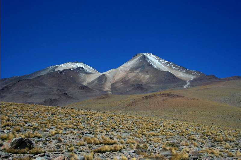
Uturunku is a cone in a desolate landscape, with an adjacent smaller non-conical mountain. By Ceky - wikipedia france, CC BY-SA 3.0, https://commons.wikimedia.org/w/index.php?curid=1375208
Uturunku's lavas contain biotite,[3] hypersthene,[8] ilmenite, magnetite, orthopyroxene and plagioclase. They also contain inclusions, a few percent andesite, norite and xenoliths derived from the crust containing sillimanite gneiss and igneous rocks. Morphological and chemical analysis of the eruption products indicate that the dacites formed by fractional crystallization of andesite magma. Some of the dacite magma was modified by mixing of dacite and andesite magmas. The magma also underwent oxidation and degassing during ascent.[3] Analysis of the erupted dacites indicate that the magma was nearly water-saturated and stored at depths given differently as 2–4 kilometres (1.2–2.5 mi)[9] or 5.7 kilometres (3.5 mi)[10] by studies, and temperatures of 870 °C (1,600 °F). The chemistry and microstructure suggest that Uturunku magmas formed in magma chambers subject to episodic replenishment with hotter magmas.[9][10] Major and trace element analysis indicates a substantial similarity of Uturunku lavas to local ignimbrites.[11]
1.1. Regional Setting
The Central Andes and the Central Volcanic Zone formed in response to the subduction at a rate of about 6.5 centimetres per year (2.6 in/year) at an angle of 25° of the Nazca Plate below the South American Plate.[12] Uturuncu is located in the back-arc region of this subduction.[13] The onset of the modern orogeny was precipitated by the breakup of the Farallon Plate 26 mya, resulting in accelerated and steepening subduction of the now-Nazca plate. After a 14 million year phase of shallow subduction, 12 mya the subduction steepened to the current angle of 30° by 3 mya. The Altiplano–Puna volcanic complex (APVC) formed during this time.[3]
The APVC is an area of the Andes where an upper crust magmatic system has generated large-scale ignimbrite eruptions and calderas between one and ten mya. The melting of the crust that generated this activity is also thought to have contributed to crustal thickening in the area to about 70 kilometres (43 mi). An underlying area of partial melts (around 20% volume) with low density and seismic velocity and high conductivity has been identified with a top at 17 kilometres (11 mi) depth.[14] This area accumulates magma at an average rate of 0.001 cubic kilometres per year (0.00024 cu mi/a).[15] This area of melt arches upward and has its thickest and shallowest parts below Uturunku, with the slowest seismic velocity zones located south and west of the volcano.[16]
1.2. Local Setting
Uturunku is located 70 kilometres (43 mi) west of the main volcanic arc.[17] Starting 11-10 mya ago during the Neogene, the Lípez area was affected by ignimbritic activity.[18] Cerro Lípez formed in the Miocene from dacites and rhyolites intruding into Middle Miocene ash flows. Ignimbritic activity includes the 2.89 mya Pastos Grandes, the 1.98 mya Laguna Colorada and the 0.7 mya El Tatio ignimbrite. The smaller Vilama caldera formed 8.4 mya and the larger Panizo caldera between 6.8–7.9 mya. The Chascon–Runtu Jarita complex was the last active volcano in the area with intrusions dated 85,000 years ago. Further west on the border between Bolivia and Chile activity continues today with Iru Phutunqu, Olca, Ollagüe, Putana and others.[19]
The volcano is constructed on local ignimbrite layers, the 8.1 mya Vilama and the 5.65 mya Guacha ignimbrites.[10] The Lipez–Coranzuli lineament (also known as the Pastos Grandes-Cojina lineament) runs through the volcano, and seismic activity in the area is aligned to this and neighbouring NW–SE faults. These fault zones may influence the activity of the volcano[1] and are associated with caldera formation. Volcanoes in the Uturunku area rise about 1,600–1,700 metres (5,200–5,600 ft) above the surrounding terrain.[8]
2. Climate and Glaciation
Present-day climate conditions at Uturunku volcano are scarcely recorded.[20] In the region average temperatures are less than 4 °C (39 °F) with frequent frosts.[21] Most of the humidity comes from the Amazon basin in the east; this generates a decreasing gradient over the Altiplano westwards. The Lipez area is dry, receiving less than 100 millimetres per year (3.9 in/year) of precipitation. Because of this insufficient precipitation, there is no present-day glaciation on Uturunku despite the 0 °C (32 °F) isotherm being lower than the summit of the volcano and of other neighbouring summits at 5,000 metres (16,000 ft).[20]
The presence of a shallow (less than 100-metre / 330 ft) difference between the altitude of the valley bottom of the southern glacial valley, and its shoulders indicates past low-volume glaciation. Five different moraine stages between 4,800 metres (15,700 ft) and 4,850 metres (15,910 ft) altitude have been identified. Striated rocks and roche moutonnées are also present in the area. Based on helium-3 surface exposure dating, these moraines originated from Pleistocene glacier fluctuations between 65,000 and 14,000 years ago. The lowest of the moraines, and thus the largest extent of glaciation, coincides with the highstand of the "Lake Tauca" lake episode 16,000-14,000 years ago, where the Altiplano was covered by a large lake. Rapid deglaciation occurred after the disappearance of Lake Tauca 14,000 years ago.[20] During the Tauca episode, water levels rose in the lakes around Uturunku.[7]
3. Vegetation and Animal Life
The regional vegetation is classified as Puna grassland, with low biodiversity. Quinoa woods are found on the lower slopes of the volcano. Birds such as flamingoes make up much of the animal life in the area and are concentrated at open waterbodies. Andean mountain cats, southern viscachas and vicuñas form the rest of the animal life.[21] Uturunku lies within the confines of the Eduardo Avaroa Andean Fauna National Reserve.[22]
4. Eruptive History
4.1. Pre-Holocene
Uturunku was active between 890,000 and 271,000 years ago. Lavas higher up the edifice are younger and less extensive. The volcano was constructed in two phases dated by argon–argon dating, one 890,000–549,000 years ago and the younger, less extensive one 427,000–271,000 years ago. The youngest age belongs to the summit lava dome. Older estimates by the Servicio Geológico de Bolivia proposed that the northern and western flows were between 10 and 15 mya old and the summit flows older than one million years.[3]
Two lava domes south of the summit, with a combined volume of 1 km3 (0.24 cu mi), are the oldest structures of the volcano, having formed 1,050 ka and 1,041 ka. Lava flows on the southern and southwestern sides of the edifice have similar ages of 1,028 and 1,018 ka. Subsequently, two lava flows on the southern and eastern side of the volcano and a group of flows on the northeastern side erupted 890, 714 and 660 ka were the only eruptions until 595 ka. Ten domes and flows were erupted between 595–590 ka, including two large domes located north-northwest of the summit erupted at the start and end of this period. These domes formed directly on the Altiplano and are 500 m (1,600 ft) high, 1 km (0.62 mi) wide and have a combined volume of 0.4 km3 (0.096 cu mi). 549 ka the western dome was erupted 5.5 km (3.4 mi) southeast of the NNW domes; it subsequently collapsed, forming a debris avalanche that covered 1.3 km2 (0.50 sq mi). The largest lava flow from Uturunku was erupted 544 ka; this Lomo Escapa flow flowed 9 km (5.6 mi) over the ignimbrite plain. Based on a thickness of 200 m (660 ft) a volume of 1.7 km3 (0.41 cu mi) was estimated from this flow.[23]
Starting from 450,000 years ago, the morphology of the flows change. Between 458 and 387 ka flows and domes are shorter and originate mostly around the summit area; the longest flow from this phase erupted 455 ka and is 2.6 km (1.6 mi). The last major pulse occurred 316-267 ka, and its products have dimensions similar to those older than 500,000. The youngest flow in the southeastern summit area is dated 250 ka.[23]
Volcanic activity at Uturunku was episodic, with bursts of eruptions separated by between 50,000 and 180,000 years of rest,[23] with individual eruptions separated by about 6,000 - 8,000 years.[2] Eruptions were likely voluminous, with lava flow volumes of about 0.1–10 km3 (0.024–2.399 cu mi) erupted in short time periods. Such eruptions originated from ephemeral magma chambers formed by repeated transfer of magmas from the APVC melt generating zone. In these magma chambers, andesites and silica-rich magmas formed dacites that erupted to the surface when the magma chamber grew to the point of rupturing its walls. Assuming that the magma output of the volcano was a total of 170 km3 (41 cu mi), the average flux rate was less than 0.00027 km3/a (6.5×10⁻⁵ cu mi/a), below the average for local volcanoes.[3] Unusually for volcanoes in this region, Uturunku has experienced exclusively effusive eruptions.[24]
4.2. Recent Unrest
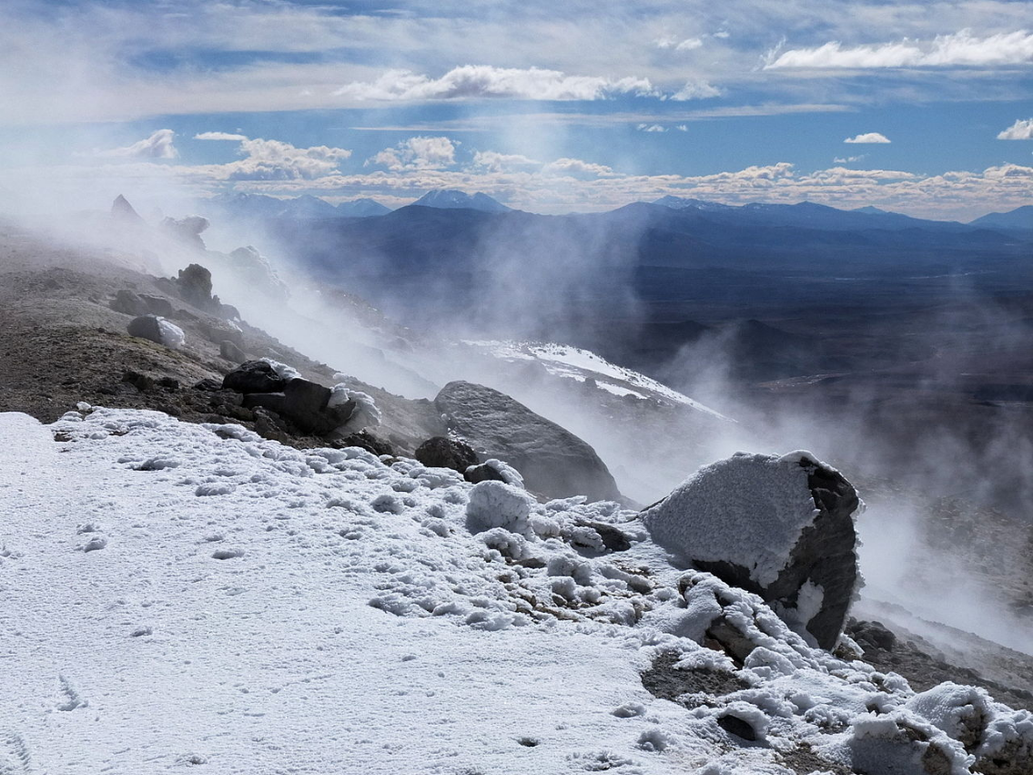
The volcano has two fields of fumaroles (<80 °C (176 °F)) in the area between Uturunku's two summits and has caused hydrothermal alteration of country rock.[3] These fumaroles form visible clouds of steam.[25] This heat may have been replenished from the APVC melt generating zone or survived since the last eruption of the volcano,[9] and appears to be deep seated considering the low temperature of the fumaroles.[26]Fumarolic activity is distinct enough to be visible from ASTER satellite image but barely visible from the ground. The temperature of the hotspot has been relatively constant in contrast to Lascar.[25] In addition, a hot spring with temperatures of 20 °C (68 °F) has been found on the northwestern flank of the volcano.[22] Seismic activity occurs beneath the volcano, with up to three earthquakes every hour.[2] The presence of lava flows overlying moraines, which could indicate post-glacial activity,[8] is controversial;[27] the summit lava flows have been glaciated.[3]
Starting in 1992, and increasing in 1998, a 70 km (43 mi) wide circular region around Uturunku has been deforming at a rate of 1–2 cm/year (0.39–0.79 in/year)[14][27] with a centre 3 kilometres (1.9 mi) from the summit of the volcano.[24] Research has indicated that the sources must be deep to create large-scale ground inflation, but above the partially molten layer of the APVC partial melt zone.[14][27] A ring of subsidence surrounds the uplift and expands the size of the deformed area to a diameter of 150 km (93 mi).[16] This subsidence occurs at a rate of about 2 mm/a (0.079 in/year).[13] The total volume changes over 14 years amount to 40,000,000,000 m3 (1.4×10¹² cu ft) at a depth of 17–30 km (11–19 mi) below the surface.[3] Magma accumulation rates of 0.01 cubic kilometres per year (0.0024 cu mi/a) have been estimated. These inflation and accumulation rates are comparable to the inflation rates at Yellowstone Caldera and Long Valley Caldera in the United States and Lazufre (Lastarria–Cerro del Azufre) in Chile .[15] The depth and scale of deformation and the absence of a large-scale hydrothermal system indicates that the ground inflation is unlikely to be hydrothermal.[3] Evidence from prehistoric levels in local lakes and river valleys indicate that the uplift did commence less than a hundred years ago; either the volcano has experienced previous episodes of uplift which were then followed by subsidence, or the current pattern of ground movement is unprecedented in the volcano's history.[7][26] There has been some variation in the uplift rate, with a temporary slowdown around 2010[28] that lasted until 2015.[24] Later InSAR observations suggest that there was a high uplift period in 1998-2003 with slower uplift before and after these years, as well as localized subsidence south of the volcano;[29] alternatively the uplift increased again in 2015. Such active surface deformation on a dormant volcano was first discovered at Uturunku and later also observed at other volcanoes; it has been called "zombie volcanism".[26]
Anomalous seismic activity was also observed centered in a source 3–4 km (1.9–2.5 mi) deep, 4 km (2.5 mi) southwest of the summit.[3] Microseismic activity was also registered. Such seismicity exceeds that of other volcanoes in the region (with the exception of Lascar during active periods, and Lastarria and San Pedro) and is unlikely to be normal background activity for the area. Some earthquake activity and seismic swarms were triggered by the 2010 Chile earthquake, which may be indicative of unstable hydromagmatic systems or interactions of the magmatic system with far field earthquake waves.[1] Hypotheses regarding the earthquake activity either consider shallow faults deforming in a brittle manner, groundwater movements or a combination of these with a disturbance of a hydrothermal system. The presence of partial melts below the Altiplano–Puna volcanic complex suggests a magmatic origin of the activity.[14]
Gravimetric data indicate that a vertical low density body connects Uturunku with the APVC magma body at a depth of 25 km (16 mi). Several such bodies with radii 12–20 km (7.5–12.4 mi) are found beneath the APVC. In 2013, del Potro et al. estimated that this body may contain 25% by volume of molten dacite.[14] The exact shape of this body is unknown due to insufficient resolution of the gravimetric and magnetotelluric measurements.[7] The formation of buoyant mobile layers following heating may destabilize this magma mush and cause lavas to accumulate a few kilometres below the volcano and erupt.[23]
Analysis of the electrical conductivity of the ground beneath Uturunku has shown the presence of layers where electrical conductivity is high. Apart from one shallow layer that may be associated with a hydrothermal system or past hydrothermal alteration, three large structures (volumes of 500 km3 (120 cu mi)) in the shape of dykes have been identified. They may be magma chambers or the result of hydrothermal phenomena. Most likely, they are magma bodies containing large amounts of saline water.[13]
5. Threats
The magma intrusion rate below Uturunku is considerably larger than the magma output of the Pleistocene volcano, being comparable to the magma flux of historic eruptions and estimates of magma generation rates in local caldera forming magma chambers. Evidence for the formation of such a magma chamber is elusive but might be hidden by the deformation activity of the APVC melt generation zone.[3] Uturunku may be developing into a supervolcano,[30] and a caldera forming super-eruption may occur there;[31] this possibility has resulted in international media attention.[30][32] However, there is no evidence of eruptible magma near the surface, meaning that such an eruption could not occur in the near future.[26]
References
- Jay, Jennifer A.; Pritchard, Matthew E.; West, Michael E.; Christensen, Douglas; Haney, Matthew; Minaya, Estela; Sunagua, Mayel; McNutt, Stephen R. et al. (2011). "Shallow seismicity, triggered seismicity, and ambient noise tomography at the long-dormant Uturuncu Volcano, Bolivia". Bulletin of Volcanology 74 (4): 817–837. doi:10.1007/s00445-011-0568-7. ISSN 0258-8900. Bibcode: 2012BVol...74..817J. https://dx.doi.org/10.1007%2Fs00445-011-0568-7
- McFarlin, Heather; Christensen, Douglas; McNutt, Stephen R.; Ward, Kevin M.; Ryan, Jamie; Zandt, George; Thompson, Glenn (2 February 2018). "Receiver function analyses of Uturuncu volcano, Bolivia and vicinity" (in en). Geosphere 14 (1): 50. doi:10.1130/GES01560.1. https://pubs.geoscienceworld.org/gsa/geosphere/article/14/1/50/522694/receiver-function-analyses-of-uturuncu-volcano.
- Sparks, R. S. J.; Folkes, C. B.; Humphreys, M. C. S.; Barfod, D. N.; Clavero, J.; Sunagua, M. C.; McNutt, S. R.; Pritchard, M. E. (2008). "Uturuncu volcano, Bolivia: Volcanic unrest due to mid-crustal magma intrusion". American Journal of Science 308 (6): 727–769. doi:10.2475/06.2008.01. ISSN 0002-9599. https://dx.doi.org/10.2475%2F06.2008.01
- Muir, Duncan D.; Blundy, Jon D.; Hutchinson, Michael C.; Rust, Alison C. (20 February 2014). "Petrological imaging of an active pluton beneath Cerro Uturuncu, Bolivia". Contributions to Mineralogy and Petrology 167 (3). doi:10.1007/s00410-014-0980-z. https://dx.doi.org/10.1007%2Fs00410-014-0980-z
- Donald I. Bleiwas and Robert G. Christiansen. (1975). "Geology and mineral resources of the Altiplano and Cordillera Occidental, Bolivia". U.S. GEOLOGICAL SURVEY BULLETIN 1975. U.S. Geological Survey and Servicio Geologico de Bolivia. http://pubs.usgs.gov/bul/1975/report.pdf. Retrieved August 27, 2015.
- Richard, Nicolás; Moraga, Jorge; Saavedra, Adrián (2016-01-01). "El camión en la puna de Atacama (1930-1980). Mecánica, espacio y saberes en torno a un objeto técnico liminal (Estudios Atacameños. Arqueología y Antropología Surandinas, ISI)" (in es). Artículos indexados de académicos FACSO 0: 187. http://revistafacso.ucentral.cl/index.php/indexados/article/view/257.
- Perkins, Jonathan P.; Finnegan, Noah J.; Henderson, Scott T.; Rittenour, Tammy M. (August 2016). "Topographic constraints on magma accumulation below the actively uplifting Uturuncu and Lazufre volcanic centers in the Central Andes". Geosphere 12 (4): 1078–1096. doi:10.1130/GES01278.1. https://dx.doi.org/10.1130%2FGES01278.1
- Kussmaul, S.; Hörmann, P.K.; Ploskonka, E.; Subieta, T. (1977). "Volcanism and structure of southwestern Bolivia". Journal of Volcanology and Geothermal Research 2 (1): 73–111. doi:10.1016/0377-0273(77)90016-6. ISSN 0377-0273. Bibcode: 1977JVGR....2...73K. https://dx.doi.org/10.1016%2F0377-0273%2877%2990016-6
- Laumonier, Mickael; Gaillard, Fabrice; Sifre, David (2014). "The effect of pressure and water concentration on the electrical conductivity of dacitic melts: Implication for magnetotelluric imaging in subduction areas". Chemical Geology 418: 66–76. doi:10.1016/j.chemgeo.2014.09.019. ISSN 0009-2541. https://dx.doi.org/10.1016%2Fj.chemgeo.2014.09.019
- Muir, D. D.; Blundy, J. D.; Rust, A. C.; Hickey, J. (2014). "Experimental Constraints on Dacite Pre-eruptive Magma Storage Conditions beneath Uturuncu Volcano". Journal of Petrology 55 (4): 749–767. doi:10.1093/petrology/egu005. ISSN 0022-3530. https://dx.doi.org/10.1093%2Fpetrology%2Fegu005
- Fernàndez, A. C.; Hörmann, P. K.; Kussmaul, S.; Meave, J.; Pichler, H.; Subieta, T. (1973). "First petrologic data on young volcanic rocks of SW-Bolivia". TMPM Tschermaks Mineralogische und Petrographische Mitteilungen 19 (3): 149–172. doi:10.1007/BF01167425. ISSN 0041-3763. Bibcode: 1973TMPM...19..149F. https://dx.doi.org/10.1007%2FBF01167425
- Kühn, Christine; Küster, Jonas; Brasse, Heinrich (2014). "Three-dimensional inversion of magnetotelluric data from the Central Andean continental margin". Earth, Planets and Space 66 (1): 112. doi:10.1186/1880-5981-66-112. ISSN 1880-5981. Bibcode: 2014EP&S...66..112K. https://dx.doi.org/10.1186%2F1880-5981-66-112
- Comeau, Matthew J.; Unsworth, Martyn J.; Cordell, Darcy (October 2016). "New constraints on the magma distribution and composition beneath Volcán Uturuncu and the southern Bolivian Altiplano from magnetotelluric data". Geosphere 12 (5): 1391–1421. doi:10.1130/GES01277.1. https://dx.doi.org/10.1130%2FGES01277.1
- Hickey, James; Gottsmann, Joachim; del Potro, Rodrigo (2013). "The large-scale surface uplift in the Altiplano-Puna region of Bolivia: A parametric study of source characteristics and crustal rheology using finite element analysis". Geochemistry, Geophysics, Geosystems 14 (3): 540–555. doi:10.1002/ggge.20057. ISSN 1525-2027. https://dx.doi.org/10.1002%2Fggge.20057
- Annen, C. (2009). "From plutons to magma chambers: Thermal constraints on the accumulation of eruptible silicic magma in the upper crust". Earth and Planetary Science Letters 284 (3–4): 409–416. doi:10.1016/j.epsl.2009.05.006. ISSN 0012-821X. Bibcode: 2009E&PSL.284..409A. https://dx.doi.org/10.1016%2Fj.epsl.2009.05.006
- Ward, Kevin M.; Zandt, George; Beck, Susan L.; Christensen, Douglas H.; McFarlin, Heather (2014). "Seismic imaging of the magmatic underpinnings beneath the Altiplano-Puna volcanic complex from the joint inversion of surface wave dispersion and receiver functions". Earth and Planetary Science Letters 404: 43–53. doi:10.1016/j.epsl.2014.07.022. ISSN 0012-821X. Bibcode: 2014E&PSL.404...43W. https://dx.doi.org/10.1016%2Fj.epsl.2014.07.022
- Pritchard, M. E.; Henderson, S. T.; Jay, J. A.; Soler, V.; Krzesni, D. A.; Button, N.E.; Welch, M. D.; Semple, A. G. et al. (2014). "Reconnaissance earthquake studies at nine volcanic areas of the central Andes with coincident satellite thermal and InSAR observations". Journal of Volcanology and Geothermal Research 280: 90–103. doi:10.1016/j.jvolgeores.2014.05.004. ISSN 0377-0273. Bibcode: 2014JVGR..280...90P. https://dx.doi.org/10.1016%2Fj.jvolgeores.2014.05.004
- Salisbury, M. J.; Jicha, B. R.; de Silva, S. L.; Singer, B. S.; Jimenez, N. C.; Ort, M. H. (21 December 2010). "40Ar/39Ar chronostratigraphy of Altiplano-Puna volcanic complex ignimbrites reveals the development of a major magmatic province". Geological Society of America Bulletin 123 (5–6): 821–840. doi:10.1130/B30280.1. https://dx.doi.org/10.1130%2FB30280.1
- Deroin, Jean-Paul; Téreygeol, Florian; Cruz, Pablo; Guillot, Ivan; Méaudre, Jean-Charles (2012). "Integrated non-invasive remote-sensing techniques and field survey for the geoarchaeological study of the Sud Lípez mining district, Bolivia". Journal of Geophysics and Engineering 9 (4): S40–S52. doi:10.1088/1742-2132/9/4/S40. ISSN 1742-2132. Bibcode: 2012JGE.....9S..40D. https://dx.doi.org/10.1088%2F1742-2132%2F9%2F4%2FS40
- Blard, Pierre-Henri; Lave, Jérôme; Farley, Kenneth A.; Ramirez, Victor; Jimenez, Nestor; Martin, Léo C. P.; Charreau, Julien; Tibari, Bouchaïb et al. (2014). "Progressive glacial retreat in the Southern Altiplano (Uturuncu volcano, 22°S) between 65 and 14ka constrained by cosmogenic 3He dating". Quaternary Research 82 (1): 209–221. doi:10.1016/j.yqres.2014.02.002. ISSN 0033-5894. Bibcode: 2014QuRes..82..209B. https://dx.doi.org/10.1016%2Fj.yqres.2014.02.002
- "RN de Fauna Andina Eduardo Avaroa" (in es). http://www.sernap.gob.bo/index.php/areas-protegidas/reserva-nacional/44-areas-protegidas/reserva-nacional-cat/57-cotapata-2?showall=1. Retrieved 13 June 2018.
- "Conozcamos los peligros geológicos en la región andina" (in es). 2007. p. 69. http://bvpad.indeci.gob.pe/doc/pdf/esp/doc1598/doc1598-contenido.pdf. Retrieved 13 June 2018.
- Muir, D. D.; Barfod, D. N.; Blundy, J. D.; Rust, A. C.; Sparks, R. S. J.; Clarke, K. M. (2015). "The temporal record of magmatism at Cerro Uturuncu, Bolivian Altiplano". Geological Society, London, Special Publications 422: 57–83. doi:10.1144/SP422.1. ISSN 0305-8719. https://dx.doi.org/10.1144%2FSP422.1
- Maher, Sean; Kendall, J.-Michael (August 2018). "Crustal anisotropy and state of stress at Uturuncu Volcano, Bolivia, from shear-wave splitting measurements and magnitude–frequency distributions in seismicity" (in en). Earth and Planetary Science Letters 495: 38–49. doi:10.1016/j.epsl.2018.04.060. ISSN 0012-821X. https://www.sciencedirect.com/science/article/pii/S0012821X18302735.
- Jay, J. A.; Welch, M.; Pritchard, M. E.; Mares, P. J.; Mnich, M. E.; Melkonian, A. K.; Aguilera, F.; Naranjo, J. A. et al. (2013). "Volcanic hotspots of the central and southern Andes as seen from space by ASTER and MODVOLC between the years 2000 and 2010". Geological Society, London, Special Publications 380 (1): 161–185. doi:10.1144/SP380.1. ISSN 0305-8719. Bibcode: 2013GSLSP.380..161J. https://dx.doi.org/10.1144%2FSP380.1
- Pritchard, M.E.; de Silva, S.L.; Michelfelder, G.; Zandt, G.; McNutt, S.R.; Gottsmann, J.; West, M.E.; Blundy, J. et al. (29 March 2018). "Synthesis: PLUTONS: Investigating the relationship between pluton growth and volcanism in the Central Andes" (in en). Geosphere 14 (3): 954–982. doi:10.1130/GES01578.1. ISSN 1553-040X. https://pubs.geoscienceworld.org/gsa/geosphere/article/14/3/954/529992/synthesis-plutons-investigating-the-relationship.
- Pritchard, M. E.; Simons, M. (2004). "An InSAR-based survey of volcanic deformation in the central Andes". Geochemistry, Geophysics, Geosystems 5 (2): n/a–n/a. doi:10.1029/2003GC000610. ISSN 1525-2027. Bibcode: 2004GGG.....5.2002P. https://dx.doi.org/10.1029%2F2003GC000610
- Henderson, Scott T.; Pritchard, Matthew E. (1 November 2017). "Time-dependent deformation of Uturuncu volcano, Bolivia, constrained by GPS and InSAR measurements and implications for source models" (in en). Geosphere 13 (6): 1834. doi:10.1130/GES01203.1. https://pubs.geoscienceworld.org/gsa/geosphere/article/13/6/1834/519604/time-dependent-deformation-of-uturuncu-volcano.
- Lau, Nicholas; Tymofyeyeva, Ekaterina; Fialko, Yuri (June 2018). "Variations in the long-term uplift rate due to the Altiplano–Puna magma body observed with Sentinel-1 interferometry" (in en). Earth and Planetary Science Letters 491: 43–47. doi:10.1016/j.epsl.2018.03.026. ISSN 0012-821X. https://www.sciencedirect.com/science/article/pii/S0012821X18301481.
- Friedman-Rudovsky, Jean (February 13, 2012). "Growth Spurt at a Bolivian Volcano Is Fertile Ground for Study". The New York Times. https://www.nytimes.com/2012/02/14/science/a-fascinating-growth-spurt-at-the-uturuncu-volcano-in-bolivia.html. Retrieved August 27, 2015.
- Matthews, Naomi E.; Smith, Victoria C.; Costa, Antonio; Durant, Adam J.; Pyle, David M.; Pearce, Nicholas J. G. (2012). "Ultra-distal tephra deposits from super-eruptions: Examples from Toba, Indonesia and Taupo Volcanic Zone, New Zealand". Quaternary International 258: 54–79. doi:10.1016/j.quaint.2011.07.010. ISSN 1040-6182. https://dx.doi.org/10.1016%2Fj.quaint.2011.07.010
- Axel Bojanowski (March 26, 2012). "Anden: Forscher entdecken neuen Supervulkan" (in de). Spiegel Online Wissenschaft. Der Spiegel (Hamburg). http://www.spiegel.de/wissenschaft/natur/uturuncu-in-den-anden-forscher-entdecken-neuen-supervulkan-a-823405.html. Retrieved August 27, 2015.

