Submitted Successfully!
To reward your contribution, here is a gift for you: A free trial for our video production service.
Thank you for your contribution! You can also upload a video entry or images related to this topic.
Version Summary Created by Modification Content Size Created at Operation
1 -- 2471 2022-08-16 12:16:40 |
2 format correct -1 word(s) 2470 2022-08-17 06:18:44 |

Video Upload Options

Do you have a full video?

Confirm

Are you sure to Delete?
Cite
If you have any further questions, please contact Encyclopedia Editorial Office.
Askarizad, R.;  He, J.;  Khotbehsara, E.M. Historical Neighborhoods in Creating a Cognitive Map. Encyclopedia. Available online: https://encyclopedia.pub/entry/26190 (accessed on 26 April 2024).
Askarizad R,  He J,  Khotbehsara EM. Historical Neighborhoods in Creating a Cognitive Map. Encyclopedia. Available at: https://encyclopedia.pub/entry/26190. Accessed April 26, 2024.
Askarizad, Reza, Jinliao He, Elham Mehrinejad Khotbehsara. "Historical Neighborhoods in Creating a Cognitive Map" Encyclopedia, https://encyclopedia.pub/entry/26190 (accessed April 26, 2024).
Askarizad, R.,  He, J., & Khotbehsara, E.M. (2022, August 16). Historical Neighborhoods in Creating a Cognitive Map. In Encyclopedia. https://encyclopedia.pub/entry/26190
Askarizad, Reza, et al. "Historical Neighborhoods in Creating a Cognitive Map." Encyclopedia. Web. 16 August, 2022.
Historical Neighborhoods in Creating a Cognitive Map
Edit

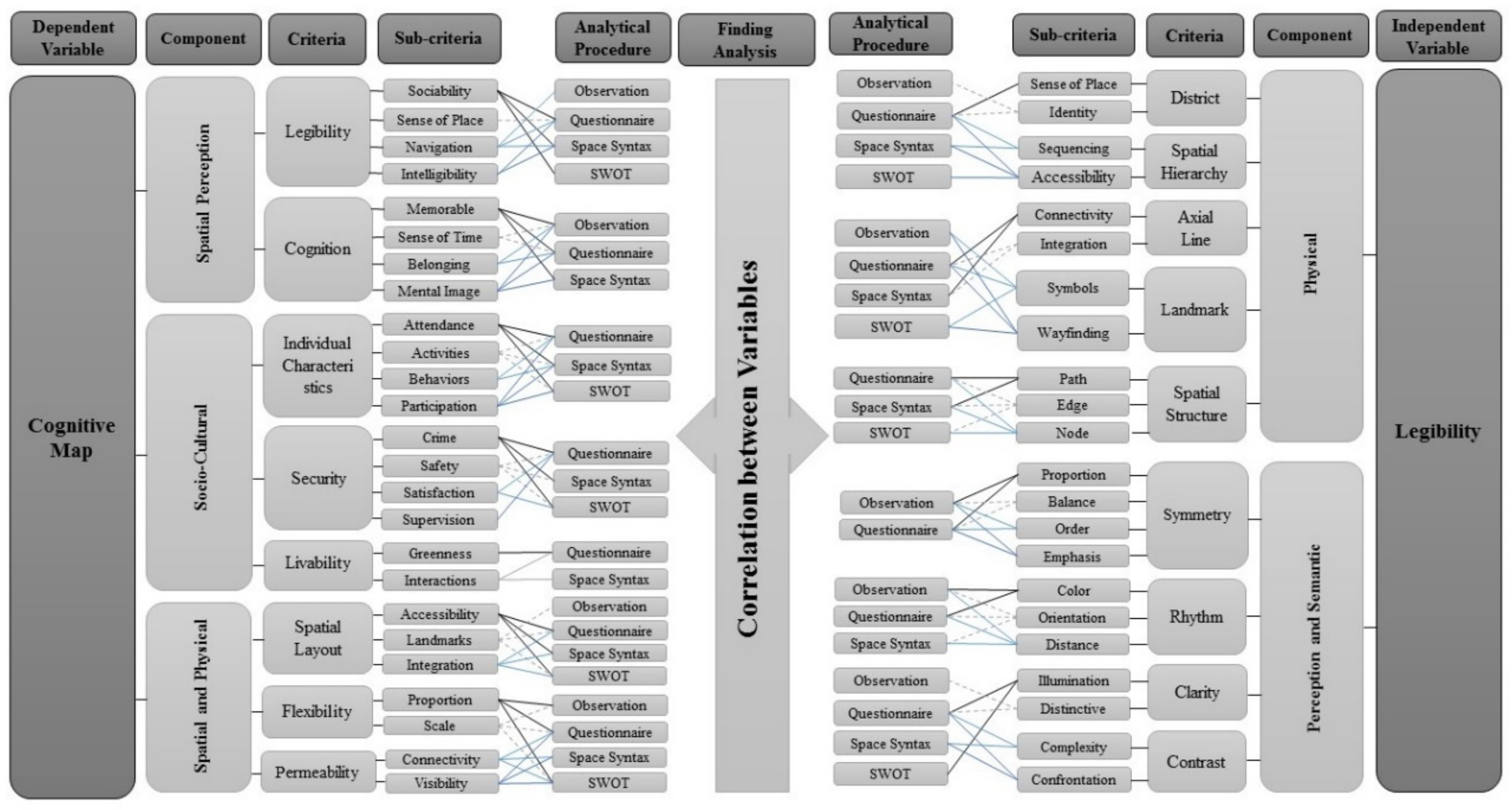
Nowadays, historical neighborhoods in Iran are in a state of decay due to the lack of spatial legibility with respect to their organic spatial layout. Hence, the level of interaction among people and their perception of the environment has gradually diminished. Historical neighborhoods no longer possess their former prosperity and function, and citizens prefer to inhabit neighborhoods with newer configurations to meet their demands.  The role of the spatial legibility of historical neighborhoods in creating a suitable cognitive map for citizens was investigated. Quantitative and qualitative methods were applied using a questionnaire and simulation test instruments. In addition, in order to analyze the spatial configuration of the target areas, the Space Syntax method was implemented using Depthmap 10. The findings indicated that landmarks and navigation signs were identified as the most important factors affecting legibility from the viewpoint of users. 

cognitive map historical neighborhood intelligibility landmark legibility mental image permeability space syntax spatial configuration sustainable development

1. Introduction

According to their perceptions and experiences, users of urban spaces acquire some sort of psychological perception of such spaces [1]. In other words, different people create different mental images of the world around them [2]. These images comprise different experiences owing to the fact that they do not replicate the same reality, and individual differences are associated with mental imagery capabilities [3]. In an urban space, a cognitive map of a city is also associated with sensory influences [4], personal and ethnic differences [5][6][7], collective experiences [8], aesthetic perceptions, and cultural values [9]. In this regard, mental imagery and cognitive maps are an important topic in the field of contemporary urban design and planning, and have recently become one of the main axes of urban landscaping [10]. Examining each of the procedures regarding the extraction of people’s mental maps represents an attempt to use such methods in a comprehensive manner [11].
Urban landmarks and symbols should also have the characteristics that make a city legible to citizens, improve their level of visual knowledge and instill a favorable sense of presence in urban spaces [12]. In this respect, landmarks can be defined as prominent urban elements that make the urban fabric more legible and facilitate navigation [13]. Multiple studies have validated the overall correlation between landmarks and the creation of cognitive maps [10][13][14][15]. Accordingly, citizens feel a sense of belonging to their city, and believe themselves to be obliged in participating in the preservation and maintenance of urban spaces, including their beautification [16]. Cognitive maps can sometimes originate from the senses of touch, taste and hearing [17][18]. Numerous studies revealed that cognitive knowledge is more coherent in a structure that is relatively easy to understand [19][20][21][22][23]. A mental image or cognitive map covers all of an individual’s experiences of a given phenomenon and becomes part of his/her subconscious [24]. In other words, it can be said that a cognitive map is a reflection of life in the mind of a person, of which a certain aspect can be selected at any time and explored [25].
Accordingly, spatial cognition plays an undeniable role in the activities which characterize behavioral patterns [26]. This trend can be very effective in reviving the intrinsic motivation of citizens and making the surrounding environment more legible [27][28][29][30]. In this respect, legibility can be defined as the possibility of organizing an environment into an imaginable and coherent pattern [31]. These valuable points, as well as other landmarks, should be emphasized in terms of activity and events, so that in the minds of users, urban spaces consistently act as reference points [32][33][34]. According to these concepts, the performance and efficiency of settlements can be measured by the amount of spatial valuation and the cognitive maps formed in the minds of users [35]. Since the values that enter this process are not physically compatible with each other, mental characteristics must also be considered when examining these concepts [36]. Although legibility is by no means the only attribute of a beautiful city, it becomes significant when researchers consider the human living environment, i.e., the size and complexity of a city. In this respect, researchers must not consider a city alone, but must observe it from the perspective of its inhabitants [37].
In this regard, historical textures consist of initial urban development, located in the old parts of cities [38]. Due to their historical structure and socio-cultural significance, historical textures are allotted importance in the process of urban sustainable development [38]. Previous literature supports the fact that residents in traditional textures are profoundly attached to their neighborhoods [39]. More recent studies highlighted the fact that traditional neighborhood design promotes a level of human cognition which makes it possible to perceive the built environment in a more convenient way [40]. Accordingly, the concept of imageability has been developed in order to correlate the association between traditional neighborhood patterns and human cognition [37]. Scholars have argued that a particular physical elements and their arrangement have the ability to draw attention, stimulate emotions and create a perennial impression which may eventually lead to placemaking [41]. Indeed, elements of historical neighborhoods such as vernacular architecture, narrow streets, elaborate facades and even bilateral symmetry have a considerable impact on imageability [40].
Nowadays, the notion of sustainable development in some contemporary cities in Iran is restricted in modern districts. According to field studies conducted in Lahijan city, northern Iran, the level of interaction among people and their perception of the environment are at very low levels due to weaknesses in objective and subjective characteristics. This factor has ultimately led to a significant diminution in vitality and security in these spaces. In this process, such neighborhoods no longer have their former prosperity and purpose, and citizens prefer neighborhoods with newer configuration structures to meet their needs. However, the identity of such neighborhoods depends on their antiquity and whether the continuation of such a process will lead to the destruction of such contexts, i.e., whether their historical values have a significant potential to create a sense of belonging among citizens. Accordingly, one of the most important reasons behind the decline of historical neighborhoods is the lack of proper legibility in such neighborhoods. As such, the identity patterns of such neighborhoods are forgotten as time goes on. On the one hand, forgetting the identity patterns, and on the other hand, the organic and unplanned texture of such spaces, leads to the loss of a sense of vitality in such neighborhoods. The purpose of this entry was to investigate the spatial legibility efficacy of historical neighborhoods in creating a suitable cognitive map for citizens. Accordingly, the following questions were posed:
  • Is there a significant correlation between spatial legibility and creating a cognitive map for citizens in historical neighborhoods of Lahijan city?
  • What is the level of legibility of the studied areas according to their spatial configuration?
  • What are the most important criteria and sub-criteria for legibility and the formation of a suitable cognitive map in urban spaces from the perspective of Lahijan inhabitants?

2. Historical Neighborhoods in Creating a Cognitive Map

Numerous studies on the effect of spatial legibility on the creation of mental images or cognitive maps have been published, some of which were reviewed in this entry in order to discern the existing scientific gap in both theoretical and practical aspects. Koseoglu and Onder [31] highlighted that subjective and objective aspects of spatial legibility depend on two main factors, namely the complexity of the urban layout and the saliency of landmarks which can be summarized as two-dimensional and three-dimensional spatial information. Previous studies validated that a Space Syntax analysis can be used as a reliable method for quantitative manipulation in the spatial configuration of urban areas in order to assess the objective facets of spatial legibility [42].
Moreover, the research outcomes of psychological and cognitive approaches in urban space indicate that imageability and spatial legibility contribute as facilitating factors of transforming space to place [43]. Studies have also indicated that the concept of environmental legibility, alongside individual differences, can affect wayfinding performance, help to obtain spatial knowledge, and improve spatial awareness in urban spaces [44]. Other studies also confirmed the fact that a balanced approach should be taken towards the use of physical exploration and simulation methods, and planners may benefit from the opportunities offered by each method [45]. In this regard, the acquisition process of individual differences and configurational attributes using a questionnaire and simulation analysis of Space Syntax is valuable in providing a comprehensive outlook towards the objectives of the present study.
In previous contextualized studies, Safari et al. [46] identified that the use of regular geometry in the spatial configuration of city centers has a significant correlation with the legibility of that particular space. In addition, a number of studies revealed that spatial legibility can increase the level of social interactions among citizens in urban parks [47]. A simulation study in a hypothetical urban environment revealed that people who remember the exact location of certain landmarks are able to navigate routes with more ease and precision [10].
Findings obtained from cognitive studies in urban spaces revealed that the most important factors in shaping cognitive maps of children consist of parks, playgrounds, green spaces and entrances [48]. Studies also indicated that the integration of urban legibility elements should enhance the level of navigation, livability, and sustainability in urban spaces [49].
The results of an experimental study indicated that users who used a GPS device had a lower perception of their cognitive maps and the group that sought the relevant path through their direct experience had a higher ability to draw their own cognitive maps [50]. The findings obtained from computational studies in historic districts of China indicated that spatial syntax methodology assists urban designers to understand where the spatial cognition of tourists takes place [51][52]. In a computational study regarding the spatial legibility and morphology of smart cities, Boeing [53] suggested that the morphological growth of cities should be based on the regular orientation of street networking in order to improve spatial legibility. Liao et al. [54] identified that the spatial pattern of historic Chinese towns and cities consists of axiality and concentric approaches which seems to have originated from traditional culture and ideologies. Further empirical studies declared that spatial arrangements have a significant influence on spatial cognition and the way that visitors perceive public spaces [55].
A review of previous studies indicated that despite an array of approaches towards the sustainable development of historical textures, very limited studies focused on the role of spatial legibility on the creation of cognitive maps in order to revitalize such districts. As a result, one of the primary contributions developed in this entry relies on scrutinizing the interrelation between legibility and cognitive maps in the context of a worn and organic structure and configuration in order to enhance the level of interaction between people and their perception of the environment. Moreover, the incorporation of such empirical studies using questionnaires and space syntax, along with the provision of SWOT-based strategies associated with the studied worn contexts, provides a comprehensive outlook for the research. Thus, the present study sought to bridge the identified scientific gap in its contribution to the existing literature towards sustainable development.

Legibility and Its Role on the Creation of Cognitive Maps in Urban Spaces

Studies indicate that legibility in urban spaces is based on the following two main factors: physical and semantic [31]. Physical factors are based on a two-dimensional spatial configuration structure, and perceptual factors (such as landmarks or urban signs) that have a three-dimensional essence [46]. Scholars in this field have long believed that the spatial configuration structure can be analyzed using quantitative methods such as Space Syntax [56][57]. According to this method, the spatial configuration of cities has a significant correlation with the movement and behavioral patterns of the people within that city [58]. These studies also revealed that axial line maps are directly related to the perception of space and thus, the ability to create a cognitive map in the minds of people in urban spaces [59].
In 2001, researchers at the Bartlett School of Architecture formulated software for the analysis of urban spaces in a further attempt to quantify this theory. This software analyzed the visibility graph analysis in the built environment in addition to measuring the axial lines [60]. In this regard, integration and connectivity were identified as two fundamental variables playing an influential role in this process [61]. Accordingly, the higher the degree of integration, the more that space is used; a higher range of connectivity can also be indicative of better accessibility within that space [57][62]. Furthermore, numerous studies demonstrate that the correlation between integration and connectivity results in spatial intelligibility; therefore, the higher the degree of correlation is, the higher the degree of spatial legibility [42][63][64][65][66]. Researchers believe that there is a significant correlation between spatial intelligibility and cognitive maps [67].
The theory of spatial legibility and mental imagery was first introduced by Kevin Lynch [37]. In field studies that were conducted in some American cities, he considered five factors that influence the legibility of urban spaces and the formation of cognitive maps. According to his findings, the five factors of district, landmark, path, node and edge are effective factors in the legibility of an urban space [37]. Subsequently, many studies were conducted on the role of landmarks in legibility and wayfinding in urban spaces [68][69][70][71]. At the same time, factors such as landmark saliency [31], visual clarity [72], distinctive colors [48], symmetry, balance and equilibrium [32] and landmarks’ distance and orientation [50] can play a significant role in the legibility of urban spaces. Studies also advocate that green gentrification within urban areas is strongly correlated with an improvement in the range of livability and the establishment of social interactions [73][74]. Moreover, the characteristics of the built environment are associated with social interaction, personal relationships, behaviors and activities among community members [75][76][77]. In addition, permeability, which is defined as the capability of the pedestrian flow to permeate an urban network system, plays a substantial role in the creation of cognitive maps [78][79] and is strongly associated with the visibility graph analysis [56].
On the other hand, in his other study, Kevin Lynch [79] examined the effect of the sense of time on the creation of cognitive maps. According to Lynch, feeling the present lead to making a meaningful connection with the past and the future, and lead to the creation of appropriate cognitive maps [79]. Meanwhile, studies illustrated that socio-cultural factors also have a significant impact on the formation of cognitive maps [80][81]. Findings have suggested that a neighborhood, as an identity setting, can also contribute significantly to promoting a sense of attachment to place [82]. Furthermore, the sense of belonging to a place is based on cognitive, emotional and spiritual aspects that lead to the promotion of identity and social participation among people [83]. This sense, which is derived from the personal characteristics and experiences of the audience, is one of the factors affecting the formation of cognitive maps or mental images for the audience [84]. Factors such as security, safety and social satisfaction are also considered to have an undeniable impact on the formation of users’ cognitive maps [85] (Figure 1).
Figure 1. Conceptual framework of the factors affecting legibility and cognitive map creation along with the analytical approach of each component according to the adopted research flow.

References

  1. Pinheiro, J. Determinants of Cognitive Maps of the World as Expressed in Sketch Maps. J. Environ. Psychol. 1998, 18, 321–339.
  2. Shepard, R.N. The mental image. Am. Psychol. 1978, 33, 125–137.
  3. Iachini, T.; Maffei, L.; Masullo, M.; Senese, V.P.; Rapuano, M.; Pascale, A.; Ruggiero, G. The experience of virtual reality: Are individual differences in mental imagery associated with sense of presence? Cogn. Process. 2019, 20, 291–298.
  4. Passini, R.; Proulx, G.; Rainville, C. The Spatio-Cognitive Abilities of the Visually Impaired Population. Environ. Behav. 1990, 22, 91–118.
  5. Isaac, A.; Marks, D. Individual differences in mental imagery experience: Developmental changes and specialization. Br. J. Psychol. 1994, 85, 479–500.
  6. Kosslyn, S.; Brunn, J.; Cave, K.; Wallach, R. Individual differences in mental imagery ability: A computational analysis. Cognition 1984, 18, 195–243.
  7. Phillips, I. Lack of imagination: Individual differences in mental imagery and the significance of consciousness. In New Waves in Philosophy of Mind; Kallestrup, J., Sprevak, M., Eds.; Palgrave Macmillan: London, UK, 2014; p. 278.
  8. Boyer, C. The City of Collective Memory: Its Historical Imagery and Architectural Entertainments; MIT Press: Cambridge, MA, USA, 1996.
  9. Pallasmaa, J. The Embodied Image: Imaginations and Imagery in Architecture; Wiley: London, UK, 2011.
  10. Bruns, C.; Chamberlain, B. The influence of landmarks and urban form on cognitive maps using virtual reality. Landsc. Urban Plan. 2019, 189, 296–306.
  11. Asadpour, A.; Faizi, M.; Mozaaffar, F.; Behzadfar, M. Typology of models and comparative study of methods in recording mental images and cognitive maps from the environment. Mon. Sci. J. Bagh-E Nazar 2015, 12, 13–22.
  12. Herzog, T.R.; Leverich, O.L. Searching for Legibility. Environ. Behav. 2003, 35, 459–477.
  13. Filomena, G.; Verstegen, J. Modelling the effect of landmarks on pedestrian dynamics in urban environments. Computers. Environ. Urban Syst. 2021, 86, 101573.
  14. Zhao, Z.; Ren, J.; Wen, Y. Spatial Perception of Urban Forests by Citizens Based on Semantic Differences and Cognitive Maps. Forests 2019, 11, 64.
  15. Kang, M.; Liu, Y.; Wang, M.; Li, L.; Weng, M. A random forest classifier with cost-sensitive learning to extract urban landmarks from an imbalanced dataset. Int. J. Geogr. Inf. Sci. 2022, 36, 496–513.
  16. Zhao, L.; Lu, Y.; Wang, B.; Chau, B.; Zhang, L. Cultivating the sense of belonging and motivating user participation in virtual communities: A social capital perspective. Int. J. Inf. Manag. 2012, 32, 574–588.
  17. Nanay, B. Multimodal mental imagery. Cortex 2018, 105, 125–134.
  18. Hamburger, K.; Knauff, M. Odors Can Serve as Landmarks in Human Wayfinding. Cogn. Sci. Multidiscip. J. 2019, 43, e12798.
  19. Canter, D.; Tagg, S. Distance estimation in cities. Environ. Behav. 1975, 7, 59–80.
  20. Evans, G.W.; Skorpanich, M.; Garling, T.; Bryant, K.; Bresolin, B. The effects of pathway configuration, landmarks and stress on environmental cognition. J. Environ. Psychol. 1984, 4, 323–335.
  21. Mondschein, A.; Moga, S.T. New Directions in Cognitive-Environmental Research. J. Am. Plan. Assoc. 2018, 84, 263–275.
  22. Hollander, J.B.; Purdy, A.; Wiley, A.; Foster, V.; Jacob, R.J.K.; Taylor, H.A.; Brunye, T.T. Seeing the city: Using eye-tracking technology to explore cognitive responses to the built environment. J. Urban. Int. Res. Placemak. Urban Sustain. 2019, 12, 156–171.
  23. Ahmadpoor, N.; Smith, A.D.; Heath, T. Rethinking legibility in the era of digital mobile maps: An empirical study. J. Urban Des. 2021, 26, 296–318.
  24. Imani, F.; Tabaeian, M. Recreating mental image with the aid of cognitive maps and its role in environmental perception. Procedia Soc. Behav. Sci. 2012, 32, 53–62.
  25. Kitchin, R. Cognitive maps: What are they and why study them? J. Environ. Psychol. 1994, 14, 1–19.
  26. Manley, E.; Filomena, G.; Mavros, P. A spatial model of cognitive distance in cities. Int. J. Geogr. Inf. Sci. 2021, 35, 2316–2338.
  27. Kozlowski, L.T.; Bryant, K.J. Sense of direction, spatial orientation, and cognitive maps. J. Exp. Psychol. Hum. Percept. Perform. 1997, 3, 590–598.
  28. Esposito, D.; Santoro, S.; Camarda, D. Agent-Based Analysis of Urban Spaces Using Space Syntax and Spatial Cognition Approaches: A Case Study in Bari, Italy. Sustainability 2020, 12, 4625.
  29. Erem, O. Revealing recreational settlement image from tourist sketch maps: A mediterranean holiday village. Asia Pac. J. Tour. Res. 2021, 26, 685–701.
  30. Liu, B.; Li, Y.; Kralj, A.; Moyle, B.; He, M. Inspiration and wellness tourism: The role of cognitive appraisal. J. Travel Tour. Mark. 2022, 39, 173–187.
  31. Koseoglu, E.; Onder, D. Subjective and objective dimensions of spatial legibility. Procedia Soc. Behav. Sci. 2011, 30, 1191–1195.
  32. Lloyd, R.; Heivly, C. Systematic Distortions in Urban Cognitive Maps. Ann. Assoc. Am. Geogr. 1987, 77, 191–207.
  33. Lloyd, R. Cognitive Maps: Encoding and Decoding Information. Ann. Assoc. Am. Geogr. 1989, 79, 101–124.
  34. Tversky, B. Distortions in cognitive maps. Geoforum 1992, 23, 131–138.
  35. Kaplan, S. Cognitive maps in perception and thought. In Image and Environment: Cognitive Mapping and Spatial Behavior; Downs, R.M., Stea, D., Eds.; Aldine Publishing Company: Chicago, IL, USA, 1973.
  36. Lynch, K. A Theory of Good City Form; MIT Press: Cambridge, MA, USA, 1981.
  37. Lynch, K. The Image of the City; MIT Press: Cambridge, MA, USA, 1960.
  38. Askarizad, R.; Safari, H.; Pourimanparast, M. The influence of organizing historical textures on citizenry satisfaction in the old texture neighbourhoods of Rasht. Emerg. Sci. J. 2017, 1, 118–128.
  39. Talen, E. Traditional Urbanism Meets Residential Affluence: An Analysis of the Variability of Suburban Preference. J. Am. Plan. Assoc. 2001, 67, 199–216.
  40. Hollander, J.B.; Sussman, A.; Levering, A.P.; Foster-Karim, C. Using Eye-Tracking to Understand Human Responses to Traditional Neighborhood Designs. Plan. Pract. Res. 2020, 35, 485–509.
  41. Ewing, R.; Bartholomew, K. Pedestrian and Transit-Oriented Design; Urban Land Institute and American Planning Association: Washington, DC, USA, 2013.
  42. Long, Y.; Baran, P.K. Does Intelligibility Affect Place Legibility? Understanding the Relationship Between Objective and Subjective Evaluations of the Urban Environment. Environ. Behav. 2012, 44, 616–640.
  43. Topcu, K.; Topcu, M. Visual Presentation of Mental Images in Urban Design Education: Cognitive Maps. Procedia Soc. Behav. Sci. 2012, 51, 573–582.
  44. Li, R.; Klippel, A. Wayfinding Behaviors in Complex Buildings: The Impact of Environmental Legibility and Familiarity. Environ. Behav. 2016, 48, 482–510.
  45. Meenar, M.; Afzalan, N.; Hajrasouliha, A. Analyzing Lynch’s City Imageability in the Digital Age. J. Plan. Educ. Res. 2019.
  46. Safari, H.; Fakourimoridani, F.; Mahdzar, S. Influence of geometry on legibility: An explanatory design study of visitors at the Kuala Lumpur City Center. Front. Archit. Res. 2016, 5, 499–507.
  47. Paydar, M.; Kamani Fard, A. The impact of legibility and seating areas on social interaction in the neighbourhood park and plaza. Archnet IJAR 2021, 15, 571–588.
  48. Rezaei Liapaee, S.; Askarizad, R.; Alborzi, F. Investigation of physical factors affecting the wayfinding of educational spaces children aged 7–12 years old in Rasht, north of Iran. Int. J. Pediatrics 2020, 8, 10689–10704.
  49. Olowoporoku, O.; Daramola, O.; Odeyemi, G.; Olaniyi, K. Navigating the urban space: Assessment of residents’ experience and satisfaction with the legibility of Ibadan municipality, Nigeria. Environ. Qual. Manag. 2020, 30, 21–33.
  50. Ahmadpoor, N.; Smith, A. Spatial knowledge acquisition and mobile maps: The role of environmental legibility. Cities 2020, 101, 102700.
  51. Xu, Y.; Rollo, J.; Jones, D.S.; Esteban, Y.; Tong, H.; Mu, Q. Towards Sustainable Heritage Tourism: A Space Syntax-Based Analysis Method to Improve Tourists’ Spatial Cognition in Chinese Historic Districts. Buildings 2020, 10, 29.
  52. Xu, Y.; Rollo, J.; Esteban, Y. Evaluating Experiential Qualities of Historical Streets in Nanxun Canal Town through a Space Syntax Approach. Buildings 2021, 11, 544.
  53. Boeing, G. Spatial information and the legibility of urban form: Big data in urban morphology. Int. J. Inf. Manag. 2021, 56, 102013.
  54. Liao, P.; Gu, N.; Yu, R.; Brisbin, C. Exploring the spatial pattern of historic Chinese towns and cities: A syntactical approach. Front. Archit. Res. 2021, 10, 598–613.
  55. Mehrinejad Khotbehsara, E.; Safari, H.; Askarizad, R.; Somasundaraswaran, K. Investigating the role of spatial configuration on visitors’ spatial cognition in health-care spaces: Case studies in Gilan, Iran. Facilities 2022, 40, 617–637.
  56. Hillier, B.; Leaman, A.; Stansall, P. Space Syntax. Environ. Plan. B Urban Anal. City Sci. 1976, 3, 147–185.
  57. Hillier, B.; Hanson, J. The Social Logic of Space; Cambridge University Press: Cambridge, MA, USA, 1984.
  58. Hillier, B.; Penn, A.; Hanson, J.; Grajewski, T.; Xu, J. Natural Movement: Or, Configuration and Attraction in Urban Pedestrian Movement. Environ. Plan. B Urban Anal. City Sci. 1993, 20, 29–66.
  59. Penn, A. Space Syntax and Spatial Cognition: Or Why the Axial Line? Environ. Behav. 2003, 35, 30–65.
  60. Turner, A.; Doxa, M.; O’Sullivan, D.; Penn, A. From Isovists to Visibility Graphs: A Methodology for the Analysis of Architectural Space. Environ. Plan. B Urban Anal. City Sci. 2001, 28, 103–121.
  61. Al Sayed, K.; Turner, A.; Hillier, B.; Lida, S.; Penn, A. Space Syntax Methodology, 4th ed.; Bartlett School of Architecture, UCL: London, UK, 2014.
  62. Hillier, B. Space and spatiality: What the built environment needs from social theory. Build. Res. Inf. 2007, 36, 216–230.
  63. Hillier, B.; Hanson, J.; Burdett, R.; Peponis, J.; Penn, A. Creating life: Or, does architecture determine anything? Archit. Comport. Archit. Behav. 1987, 3, 233–250.
  64. Peponis, J.; Hajinikoloaou, E.; Livieratos, C.; Fatouros, D.A. The Spatial Core of Urban Culture. Ekistics 1989, 56, 43–55.
  65. Hillier, B. Space is the Machine: A Configurational Theory of Architecture; Space Syntax: London, UK, 1996.
  66. Djenaihi, W.; Zemmouri, N.; Djenane, M.; van Nes, A. Noise and Spatial Configuration in Biskra, Algeria—A Space Syntax Approach to Understand the Built Environment for Visually Impaired People. Sustainability 2021, 13, 11009.
  67. Dalton, R.; Bafna, S. The syntactical image of the city: A reciprocal definition of spatial elements and spatial syntaxes. In Proceedings of the 4th International Space Syntax Symposium, London, UK, 17–19 June 2003.
  68. Raubal, M.; Winter, S. Enriching wayfinding instructions with local landmarks. In Geographic Information Science; Egenhofer, M.J., Mark, D.M., Eds.; GIScience, Lecture Notes in Computer Science; Springer: Berlin/Heidelberg, Germany, 2002; Volume 2478.
  69. Omer, I.; Goldblatt, R. The implications of inter-visibility between landmarks on wayfinding performance: An investigation using a virtual urban environment. Comput. Environ. Urban Syst. 2007, 31, 520–534.
  70. Lin, C.; Huang, T.; Lin, W.; Chang, S.; Lin, Y.; Ko, L.; Hung, D.; Chang, E. Gender differences in wayfinding in virtual environments with global or local landmarks. J. Environ. Psychol. 2012, 32, 89–96.
  71. Sharma, G.; Kaushal, Y.; Chandra, S.; Singh, V.; Mittal, A.; Dutt, V. Influence of Landmarks on Wayfinding and Brain Connectivity in Immersive Virtual Reality Environment. Front. Psychol. 2017, 8, 1220.
  72. Morello, E.; Ratti, C. A Digital Image of the City: 3D Isovists in Lynch’s Urban Analysis. Environ. Plan. B Plan. Des. 2009, 36, 837–853.
  73. Goossens, C.; Oosterlynck, S.; Bradt, L. Livable streets? Green gentrification and the displacement of longtime residents in Ghent, Belgium. Urban Geogr. 2020, 41, 550–572.
  74. Askarizad, R.; He, J. Post-pandemic urban design: The equilibrium between social distancing and social interactions within the built environment. Cities 2022, 124, 103618.
  75. Mouratidis, K. Built environment and social well-being: How does urban form affect social life and personal relationships? Cities 2018, 74, 7–20.
  76. Askarizad, R.; Safari, H. The influence of social interactions on the behavioral patterns of the people in urban spaces (case study: The pedestrian zone of Rasht Municipality Square, Iran). Cities 2020, 101, 102687.
  77. Ascensão, A.; Costa, L.; Fernandes, C.; Morais, F.; Ruivo, C. 3D Space Syntax Analysis: Attributes to Be Applied in Landscape Architecture Projects. Urban Sci. 2019, 3, 20.
  78. Pafka, E.; Dovey, K.; Aschwanden, G.D. Limits of space syntax for urban design: Axiality, scale and sinuosity. Environ. Plan. B Urban Anal. City Sci. 2020, 47, 508–522.
  79. Lynch, K. What Time Is This Place? MIT Press: Cambridge, MA, USA, 1972.
  80. Heft, H. Environment, cognition, and culture: Reconsidering the cognitive map. J. Environ. Psychol. 2013, 33, 14–25.
  81. Askarizad, R. Influence of Socio-Cultural Factors on the Formation of Architectural Spaces (Case Study: Historical Residential Houses in Iran). Creat. City Des. 2018, 2, 29–36.
  82. Lewicka, M. Place attachment, place identity, and place memory: Restoring the forgotten city past. J. Environ. Psychol. 2008, 28, 209–231.
  83. Askarizad, R.; Rezaei Liapee, S.; Mohajer, M. The Role of Sense of Belonging to the Architectural Symbolic Elements on Promoting Social Participation in Students within Educational Settings. Space Ontol. Int. J. 2021, 10, 1–18.
  84. McCunn, L.; Gifford, R. Spatial Navigation and Place Imageability in Sense of Place. Cities 2018, 74, 208–218.
  85. Carmona, M.; Heath, T.; Tiesdell, S. Public Places-Urban Spaces; Routledge: London, UK, 2012.
More
Information
Contributors MDPI registered users' name will be linked to their SciProfiles pages. To register with us, please refer to https://encyclopedia.pub/register : , ,
View Times: 390
Revisions: 2 times (View History)
Update Date: 17 Aug 2022
1000/1000