Your browser does not fully support modern features. Please upgrade for a smoother experience.
Submitted Successfully!
 +1 credit
Thank you for your contribution! You can also upload a video entry or images related to this topic.
For video creation, please contact our Academic Video Service.
| Version | Summary | Created by | Modification | Content Size | Created at | Operation |
|---|---|---|---|---|---|---|
| 1 | Syed Agha Hassnain Mohsan | -- | 2024 | 2022-07-26 09:09:20 | | | |
| 2 | Lindsay Dong | Meta information modification | 2024 | 2022-07-27 03:39:58 | | |
Video Upload Options
We provide professional Academic Video Service to translate complex research into visually appealing presentations. Would you like to try it?
Cite
If you have any further questions, please contact Encyclopedia Editorial Office.
Mohsan, S.A.H.; Khan, M.A.; Noor, F.; Ullah, I.; Alsharif, M.H. Applications of Unmanned Aerial Vehicles. Encyclopedia. Available online: https://encyclopedia.pub/entry/25512 (accessed on 20 July 2026).
Mohsan SAH, Khan MA, Noor F, Ullah I, Alsharif MH. Applications of Unmanned Aerial Vehicles. Encyclopedia. Available at: https://encyclopedia.pub/entry/25512. Accessed July 20, 2026.
Mohsan, Syed Agha Hassnain, Muhammad Asghar Khan, Fazal Noor, Insaf Ullah, Mohammed H. Alsharif. "Applications of Unmanned Aerial Vehicles" Encyclopedia, https://encyclopedia.pub/entry/25512 (accessed July 20, 2026).
Mohsan, S.A.H., Khan, M.A., Noor, F., Ullah, I., & Alsharif, M.H. (2022, July 26). Applications of Unmanned Aerial Vehicles. In Encyclopedia. https://encyclopedia.pub/entry/25512
Mohsan, Syed Agha Hassnain, et al. "Applications of Unmanned Aerial Vehicles." Encyclopedia. Web. 26 July, 2022.
Copy Citation
Unmanned aerial vehicles (UAVs), also known as drones, have come in a great diversity of several applications such as military, construction, image and video mapping, medical, search and rescue, parcel delivery, hidden area exploration, oil rigs and power line monitoring, precision farming, wireless communication and aerial surveillance. The drone industry has been getting significant attention as a model of manufacturing, service and delivery convergence, introducing synergy with the coexistence of different emerging domains.
UAVs
applications
unmanned aerial vehicles
1. Introduction
Unmanned aerial vehicles (UAVs), also known as drones, have received momentous consideration in different disciplines of military and civilian services due to their enhanced stability and endurance in several operations. Applications of UAVs are expanding exceptionally due to their advanced use in the internet of things (IoT), 5G and B5G. UAVs have been used in a variety of applications over the last decade, including object detection and tracking, public security, traffic surveillance, military operations, exploration of hidden or hazardous areas, indoor or outdoor navigation, atmospheric sensing, post-disaster operations, healthcare, data sharing, infrastructure management, emergency and crisis management, freight transportation, wildfire monitoring and logistics [1].
A UAV is commonly referred as a pilotless aircraft with the capability to fly and stay airborne without requiring any human onboard operator, providing more cost-efficient operations than equivalent manned systems, and performing cost-efficient critical mission without risking human life. UAVs can be remotely piloted, whereby control commands are provided from a ground base station (BS) through a remote control. The UAVs are also capable of performing the control operations onboard through autopilot and different sensors, including global positioning system (GPS) and inertial measurement units (IMU).
In particular, UAVs have gained significant attention from leading online retailers, including Walmart, DHL, Google, and Amazon [2][3]. Because of the constantly growing popularity of online shopping, which may have a substantial impact on client purchases, users are increasingly demanding high speed delivery services. As a result, online retailers are looking for ways to improve delivery times. Retailers, on the other hand, face a major challenge in offering ecofriendly, cost-effective, and efficient last-mile delivery. UAVs have emerged as promising solutions in this sector, with quick and innovative designs that ensure last-mile delivery while being environmentally friendly. UAVs can be deployed easily and quickly, are scalable and flexible, have the self-organization ability, are cost-efficient, and possess high maneuverability. UAVs vary widely in configuration, size, range, weight, engine type and performance characteristics in order to carry several payloads including communication gadgets, navigation equipment, sensors, and cameras. There are different classifications of UAVs according to various parameters such as configuration, engine type, weight, range and size.
2. UAV Applications
2.1. Security, Monitoring, and Surveillance
UAVs are playing an integral role in military surveillance missions. Several countries have added UAVs in their defense strategic plans. Countries are using these flying robotics machines for enemy detection, anti-poaching, border control and maritime monitoring of critical sea lanes. Low cost, reliable and versatile UAVs are currently playing a significant contribution in aerial surveillance, monitoring and survey of any specific area to prevent any illegal activity. For instance, surveillance for any threat can be detected through drones and they can be used to monitor any movement activity in any restricted area. UAV can provide these services by sensing an automatic alert with minimal manual efforts.
2.2. Disaster Management
In the case of a man-made or natural disaster such as terrorist attacks, tsunami and floods, UAVs can gain access to disaster truck locations that are hazardous for manned activity. These disasters can severely damage telecommunication infrastructure, transportation, power and water utilities. UAVs can help to collect information, necessitate rapid solutions and navigate debris. Radars, sensors and high quality cameras incorporated in UAVs can assist rescue teams to identify damage and immediately start recovery operations and send resources such as first aid medical kits and manned helicopters. UAVs can assist in finding timely disaster estimation, providing disaster alerts and help in finding efficient countermeasures. In case of wildfire, a swarm of drones containing fire extinguishers can monitor, examine and trace any area without endangering human lives. Thus, UAVs can assist in real-time coverage of large areas without risking the safety and the security of the personnel involved. Early warning through UAVs can help to rescue human beings and wildlife at risk.
2.3. Remote Sensing
Currently, amateur drone technology has been used to get high resolution imagery data of remote areas, islands, mountaintops and coastlines. UAV technology bridges the gap between airborne, spaceborne and ground-based remote sensing data. Low cost and lightweight characteristics of UAVs support quality observation with high temporal and spatial resolutions. The remote sensing capabilities of UAVs can support in disease detection, water quality monitoring, drought monitoring, oil and gas, yield estimates, hydrological modeling, biodiversity conservation, geological disaster survey, terrain survey, forest mapping, and crop monitoring. This technology can also be used for crowd sourced mapping and creation of 3D environmental maps and has become an active part of archaeology and cartography. Affordable drones can help to provide latest data that can fit land planning budget without relying on outdated mapping sources. UAVs applied to remote sensing for different applications are shown is shown in Figure 1.
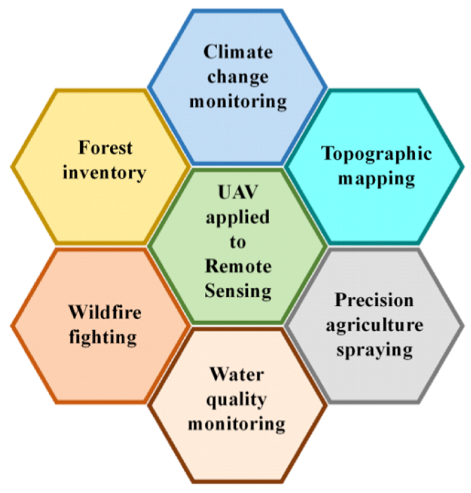
Figure 1. UAV and remote sensing applications.
2.4. Search and Rescue (SAR)
UAVs are considered to be of pivotal importance in critical scenarios such as disaster management, rescue operations and public safety. UAVs can save a lot of manpower, resources and time by offering real-time imagery data of intended locations. Consequently, a SAR team can timely detect and decide where accurately the assistance is urgently required. UAVs can speed up SAR operations in disastrous situations like missing persons, avalanches, wildfires and poisonous gas infiltration. For instance, drones can be used to track mountaineers who are lost during any mission or protect human lives lost in any remote desert or forest. Thus, drones can assist in tracing unfortunate victims or any challenging terrains or hard atmospheric conditions. Drones can provide necessary medical supplies before the arrival of any ambulance or medical team. Drones can be equipped with medical kits, life-saving jackets and food supplies to disaster-stricken areas and remote location. Such drones can provide cloth, water and necessary items to stranded human beings in inaccessible areas before the arrival of rescue crews.
2.5. Construction and Infrastructure Inspection
As-built mapping, construction monitoring and site inspection have become efficient, easy and fast through UAVs. Monitoring of construction projects from start to finish ensures quality progress of site work. It can provide reports containing imagery, video and 3D mapping to potential stakeholders. This technology can significantly support infrastructure and construction inspection applications. There is rapidly expanding interest in UAVs used for GSM towers inspection, gas pipeline monitoring, power lines inspection and construction projects monitoring [4].
2.6. Precision Agriculture
UAVs can be used in precision agriculture for collecting data from ground sensors (water quality, soil properties, moisture, etc.), pesticide spraying, disease detection, irrigation scheduling, weed detection and crop monitoring and management. The incorporation of UAVs in precision agriculture is a time-saving and cost-efficient technology that can enhance profitability, productivity and crop yields in farming systems. In addition, UAVs assist pest damage, weed monitoring, chemical spraying and agriculture management, thereby they effectuating a better yield of the crops to meet specific production requirements. UAVs along with remote sensing can be a game-changer for precision farming. It provides temporal, spatial and spectral resolution, but can also offer multi-angular observation and detailed vegetation height data. UAVs can put a significant impact on agriculture industry by performing smart aerial mapping. UAVs equipped with right sensors and appropriate cameras can monitor health of crops in terms of leaf thickness, foreign contaminants, chlorophyll level and temperature [5]. In ref. [6], WH Maes et al. briefly discussed the progress on remote sensing with UAVs in growth vigor assessment, nutrient status, pathogens and weed detection and drought stress. In the future, image processing techniques can be used to investigate plants diseases and other traits from UAV captured high resolution images.
2.7. Real-Time Monitoring of Road Traffic
Road traffic monitoring (RTM) system constitutes a domain where the integration of UAVs has captured great interest. In RTM, the complete automation of transportation sector can be achieved through UAVs [7]. It will include the automation of rescue teams, road surveyors, traffic police and field support teams. Reliable and smart UAVs can assist in the automation of these elements. UAVs have emerged as new promising tools to gather data about traffic conditions on highways. In contrast to conventional monitoring devices such as microwave sensors, surveillance videos cameras and loop detectors, cost-efficient drones can monitor huge road segments [4]. Drones can be operated by local police to get a sharp vision of road accidents or massive security crackdown on highway criminal activities such as car theft. Other applications include vehicle identification, raids on suspect vehicles, chasing armed robbers and hijackers or anyone who violates traffic rules. It can also detect vehicle over-speeding, accidents and can assist in avoiding traffic jams and mass congestions [8]. An overview of UAV services on highway is presented in Figure 2.
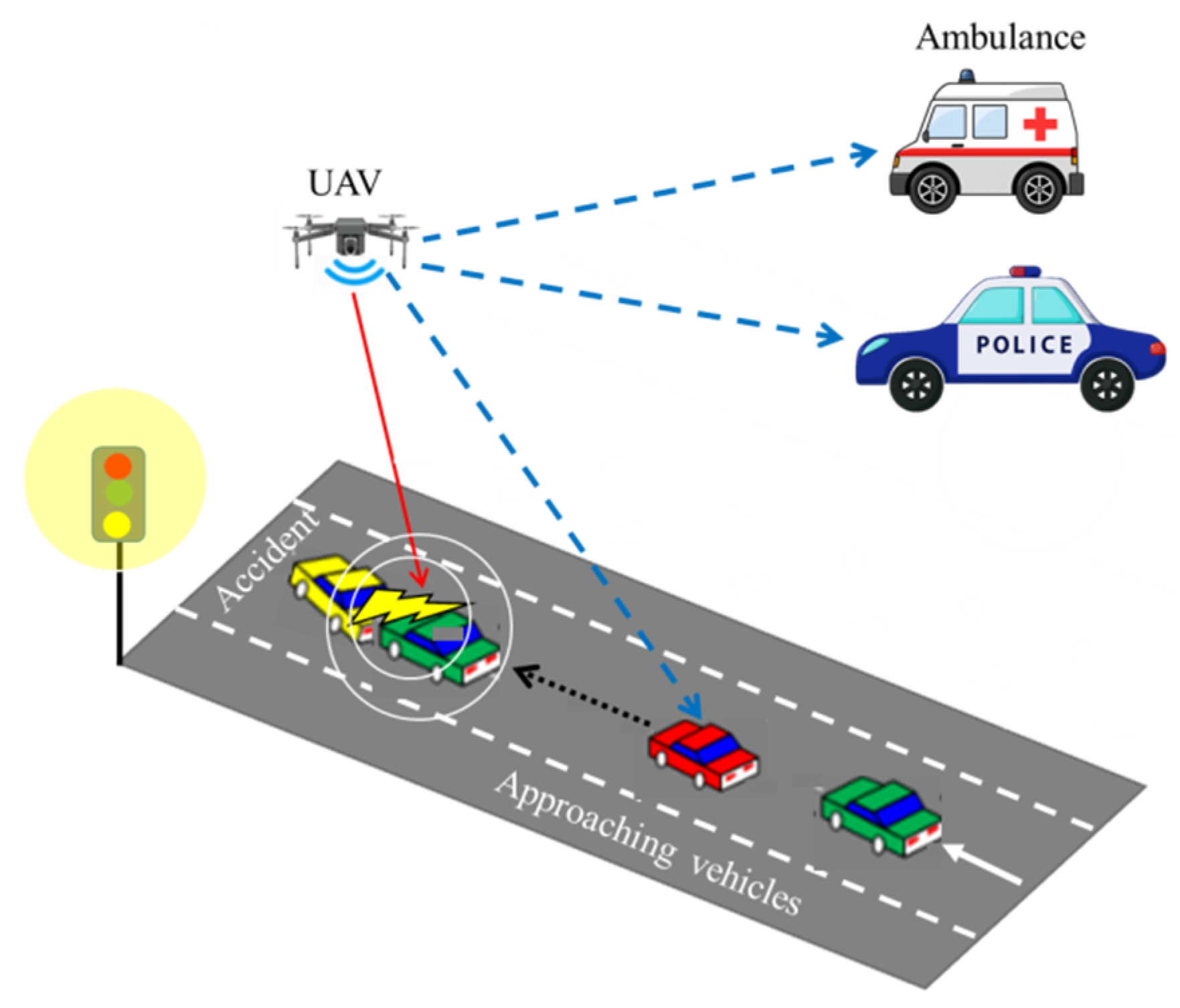
Figure 2. UAV assistance on highway.
UAVs can be used for road conditions monitoring such as indicating any cracks and giving an early warning to avoid possible accidents and reduce damages. Currently, road monitoring and inspection are implemented through manned vehicles and its automation level must be improved. The integration of road inspection technology and UAVs can significantly reduce road damages. Moreover, target detection algorithms can be implemented on road cracks images taken from UAVs for effective detection.
2.8. UAVs for Automated Forest Restoration
Another emerging research domain is to utilize UAVs for automated forest restoration (AFR). UAVs can be deployed to assist in several tasks needed for the implementation of forest restoration such as site survey, restoration strategy, site infrastructure, seeds supply, site management (fertilizing and weeding etc.), and biodiversity survey following restoration interventions [9]. Existing available technologies such as positioning and imaging sensors help UAVs to perform certain tasks including rudimentary pre-restoration site surveys and monitor several aspect of biodiversity recovery. UAVs can monitor changes in climate, ecosystem composition, and functions of forests as well as supporting inspection of forest restoration [10]. High resolution cameras installed in UAVs can provide appropriate data on forest ecosystems to assist forest restoration projects. The adequate resolution of UAV cameras can support characterizing and analysis of forest areas due to their ease in acquiring data and versatility. Furthermore, optical sensors installed in UAVs are also being utilized to attain geometric features of forests e.g., canopy diameter and height [11]. Similarly, remote sensing operations from UAVs are also reliable and efficient substitutes for traditional forest measures.
2.9. UAVs for Inspection of Overhead Power Lines
Detection and prevention of faults from power lines is crucial for the availability and reliability of electricity supply. The drawbacks of traditional techniques include high cost, cumbersome deployment and hazardous risks. Therefore, UAV-aided power line distribution and transmission lines inspection as shown in Figure 3 have gained significant interest by researchers. Inspection of power lines also refers to the safety of a power transmission grid. UAV equipped with digital camera to take images of power lines corridors is a convenient approach to support these inspection tasks [12]. UAVs can be used to trace power pylons for damaged bolts, corrosion or rust and lightning strikes. Short-circuiting of these power lines usually occurs due to harsh weather conditions, bush fires and tree falls. In a recent study [13], scholars discussed the installation of UAVs in the overhead power lines to identify faults. Both UAVs and climbing robots can be used to locate faults. UAVs can perform these inspection operations at lower cost than helicopters and low risk associated to conventional foot patrol. Among different UAVs, fixed-wing UAVs that can fly faster and higher are mostly preferred for rough inspection and vegetation monitoring. In contrast, multi-rotor UAVs are utilized to get images by hovering in the air at a closer position to the objects. Multi-rotor UAVs are suitable due to high 3D maneuverability. Despite these potentials, use of multi-rotor UAV in a confined or complex environment is challenging for the autonomous mission plan and pilot. In the future, advanced data gathering, sharing and processing algorithms should be investigated for cooperative UAVs network to support reliable, efficient and faster inspections.
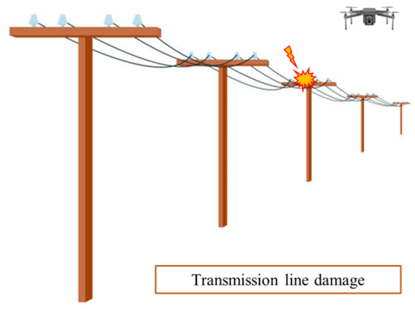
Figure 3. Inspection of power lines through UAV.
References
- Hassija, V.; Saxena, V.; Chamola, V. Scheduling drone charging for multi-drone network based on consensus time-stamp and game theory. Comput. Commun. 2019, 149, 51–61.
- Yoo, W.; Yu, E.; Jung, J. Drone delivery: Factors affecting the public’s attitude and intention to adopt. Telemat. Inform. 2018, 35, 1687–1700.
- Macrina, G.; Pugliese, L.D.P.; Guerriero, F.; Laporte, G. Drone-aided routing: A literature review. Transp. Res. Part C Emerg. Technol. 2020, 120, 102762.
- Shakhatreh, H.; Sawalmeh, A.H.; Al-Fuqaha, A.; Dou, Z.; Almaita, E.; Khalil, I.; Othman, N.S.; Khreishah, A.; Guizani, M. Unmanned Aerial Vehicles (UAVs): A survey on civil applications and key research challenges. IEEE Access 2019, 7, 48572–48634.
- Reinecke, M.; Prinsloo, T. The influence of drone monitoring on crop health and harvest size. In Proceedings of the 2017 1st International Conference on Next Generation Computing Applications (NextComp), Reduit, Mauritius, 19–21 July 2017; pp. 5–10.
- Maes, W.H.; Steppe, K. Perspectives for remote sensing with unmanned aerial vehicles in precision agriculture. Trends Plant Sci. 2019, 24, 152–164.
- Menouar, H.; Guvenc, I.; Akkaya, K.; Uluagac, A.S.; Kadri, A.; Tuncer, A. UAV-enabled intelligent transportation systems for the smart city: Applications and challenges. IEEE Commun. Mag. 2017, 55, 22–28.
- Elloumi, M.; Dhaou, R.; Escrig, B.; Idoudi, H.; Saidane, L.A. Monitoring road traffic with a UAV-based system. In Proceedings of the 2018 IEEE Wireless Communications and Networking Conference (WCNC), Barcelona, Spain, 15–18 April 2018; pp. 1–6.
- Tiansawat, P.; Elliott, S. Unmanned Aerial Vehicles for Automated Forest Restoration. Available online: https://www.researchgate.net/profile/Stephen-Elliott-2/publication/350688583_Unmanned_Aerial_Vehicles_for_Automated_Forest_Restoration/links/614b3f56a3df59440ba46d20/Unmanned-Aerial-Vehicles-for-Automated-Forest-Restoration.pdf (accessed on 1 May 2022).
- De Almeida, D.R.A.; Broadbent, E.N.; Ferreira, M.P.; Meli, P.; Zambrano, A.M.A.; Gorgens, E.B.; Resende, A.F.; de Almeida, C.T.; Amaral, C.H.D.; Corte, A.P.D.; et al. Monitoring restored tropical forest diversity and structure through UAV-borne hyperspectral and lidar fusion. Remote Sens. Environ. 2021, 264, 112582.
- Moura, M.; de Oliveira, L.; Sanquetta, C.; Bastos, A.; Mohan, M.; Corte, A. Towards amazon forest restoration: Automatic detection of species from UAV imagery. Remote Sens. 2021, 13, 2627.
- Zhang, Y.; Yuan, X.; Li, W.; Chen, S. Automatic power line inspection using UAV images. Remote Sens. 2017, 9, 824.
- Foudeh, H.A.; Luk, P.C.-K.; Whidborne, J.F. An advanced unmanned aerial vehicle (UAV) approach via learning-based control for overhead power line monitoring: A comprehensive review. IEEE Access 2021, 9, 130410–130433.
More
Information
Subjects:
Engineering, Aerospace
Contributors
MDPI registered users' name will be linked to their SciProfiles pages. To register with us, please refer to https://encyclopedia.pub/register
:
View Times:
30.8K
Revisions:
2 times
(View History)
Update Date:
27 Jul 2022
Table of Contents


Notice
You are not a member of the advisory board for this topic. If you want to update advisory board member profile, please contact office@encyclopedia.pub.
OK
Confirm
Only members of the Encyclopedia advisory board for this topic are allowed to note entries. Would you like to become an advisory board member of the Encyclopedia?
Yes
No
${ textCharacter }/${ maxCharacter }
Submit
Cancel
Back
Comments
${ item }
|
${ item.createdUser.fullName }
${ item.createdAt }
${ item.vote }
${ item.reply }
Delete
${ reply.createdUser.fullName }
${ reply.createdAt }
${ reply.vote }
Delete
There is no reply to this comment~
${ item.replyTextCharacter }/${ item.replyMaxCharacter }
Submit
Cancel
More
No more~
There is no comment~
${ textCharacter }/${ maxCharacter }
Submit
Cancel
${ selectedItem.replyTextCharacter }/${ selectedItem.replyMaxCharacter }
Submit
Cancel
Confirm
Are you sure to Delete?
Yes
No