Your browser does not fully support modern features. Please upgrade for a smoother experience.
Submitted Successfully!
 +1 credit
Thank you for your contribution! You can also upload a video entry or images related to this topic.
For video creation, please contact our Academic Video Service.
| Version | Summary | Created by | Modification | Content Size | Created at | Operation |
|---|---|---|---|---|---|---|
| 1 | Marcos Adrián Ortega-Guerrero | -- | 1975 | 2022-04-29 12:56:56 | | | |
| 2 | Rita Xu | Meta information modification | 1975 | 2022-05-05 05:23:36 | | |
Video Upload Options
We provide professional Academic Video Service to translate complex research into visually appealing presentations. Would you like to try it?
Cite
If you have any further questions, please contact Encyclopedia Editorial Office.
Ortega-Guerrero, M. Groundwater Flow System. Encyclopedia. Available online: https://encyclopedia.pub/entry/22499 (accessed on 26 July 2026).
Ortega-Guerrero M. Groundwater Flow System. Encyclopedia. Available at: https://encyclopedia.pub/entry/22499. Accessed July 26, 2026.
Ortega-Guerrero, Marcos. "Groundwater Flow System" Encyclopedia, https://encyclopedia.pub/entry/22499 (accessed July 26, 2026).
Ortega-Guerrero, M. (2022, April 29). Groundwater Flow System. In Encyclopedia. https://encyclopedia.pub/entry/22499
Ortega-Guerrero, Marcos. "Groundwater Flow System." Encyclopedia. Web. 29 April, 2022.
Copy Citation
The Independence Basin is located in a semi-arid region of Mexico, delimited predominantly by volcanic mountains. Around 30 m3/s of water are extracted from regional aquifers mainly for agro-export activities, causing declines in the water table of up to 10 m/a, increased temperature and dissolved elements that are harmful to health and the environment.
groundwater flow systems
heat transport
sustainability
1. Introduction
Description of the Study Basin
The Independence Basin (IB) is representative of the new paradigm of water management in Mexico, introduced in 2000 with the incorporation of the Gravitational Systems of Groundwater Flow into the comprehensive study of water on the scale of hydrological basins. The earlier paradigm was characterized by artificial administrative limits imposed on watersheds and aquifers that began to dominate in the 1970s and 1980s. That approach divided the natural basin, officially called the Cuenca Alta del Río La Laja (Upper La Laja River Basin), into four or six artificial administrative units [1].
Covering an area of 7000 km2, the IB is in the state of Guanajuato in the semi-arid region of Mexico (Figure 1). It forms part of the continental watershed that separates the Lerma-Chapala basin, which drains towards the Pacific Ocean, from the Balsas basin that drains into the Gulf of Mexico. Seven important municipalities exist in the IB: Dolores Hidalgo, San Felipe, San Diego de la Unión, San Luis de la Paz, Dr. Mora, San José Iturbide, and San Miguel de Allende (Figure 1). They have a combined population of over 500,000 inhabitants who depend almost exclusively on groundwater for human consumption, agriculture, and industry. Around 30 m3/s are currently being extracted from two aquifers, one granular and the other fractured. Around 80% is for agro-export industries. Various thermal anomalies are observable in springs and wells in the basin [1].
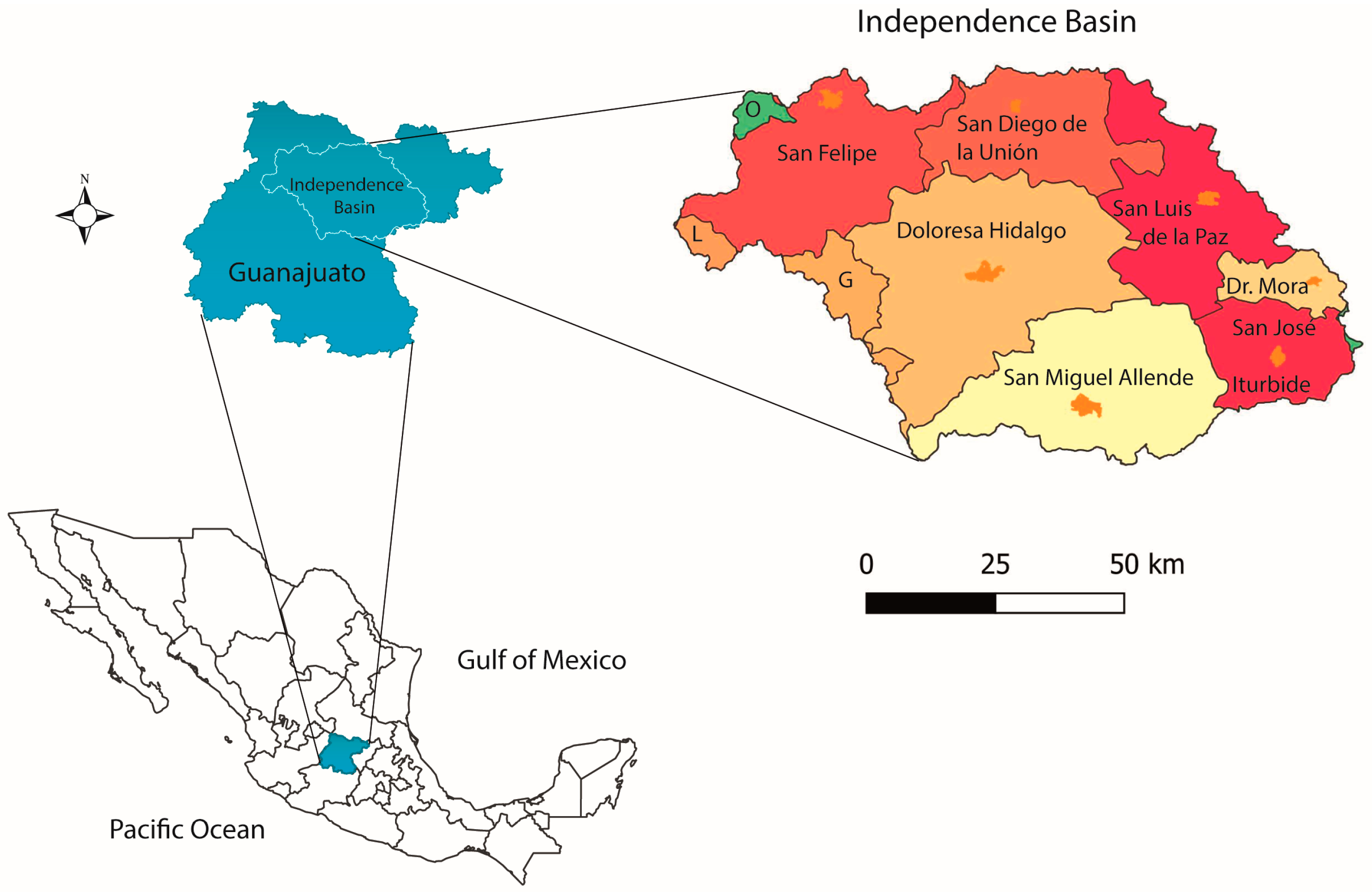
Figure 1. Location of the Independence Basin and its divide in the state of Guanajuato, central Mexico. The municipalities that comprise the IB are San Felipe, San Diego de la Unión, San Luis de la Paz, Dolores Hidalgo, San Miguel Allende, Dr. Mora, and San José Iturbide. Small fractions of the municipalities of Guanajuato (G), León (L) and Ocampo (O) also belong to the IB.
Elevations in the basin vary from 1840 m above sea level (masl) at its exit from the Allende Dam to 2900 masl in the San José Iturbide (S-SJI), San Diego de la Unión (S-SDU) and Guanajuato sierras (S-G). In the central area, an elevation of 2000 masl predominates, while altitudes in the other mountains range from 2500 to 2800 masl: Sierra Santa Bárbara (S-SB), Sierra San Luis de la Paz-Mineral de Pozos (S-SLP-MP), Sierra Doctor Mora (S-DM), Sierra San José Iturbide-Zamorano (S-SJI), Sierra Picachos-Támbula, and Sierra Codornices (S-C) (Figure 2).
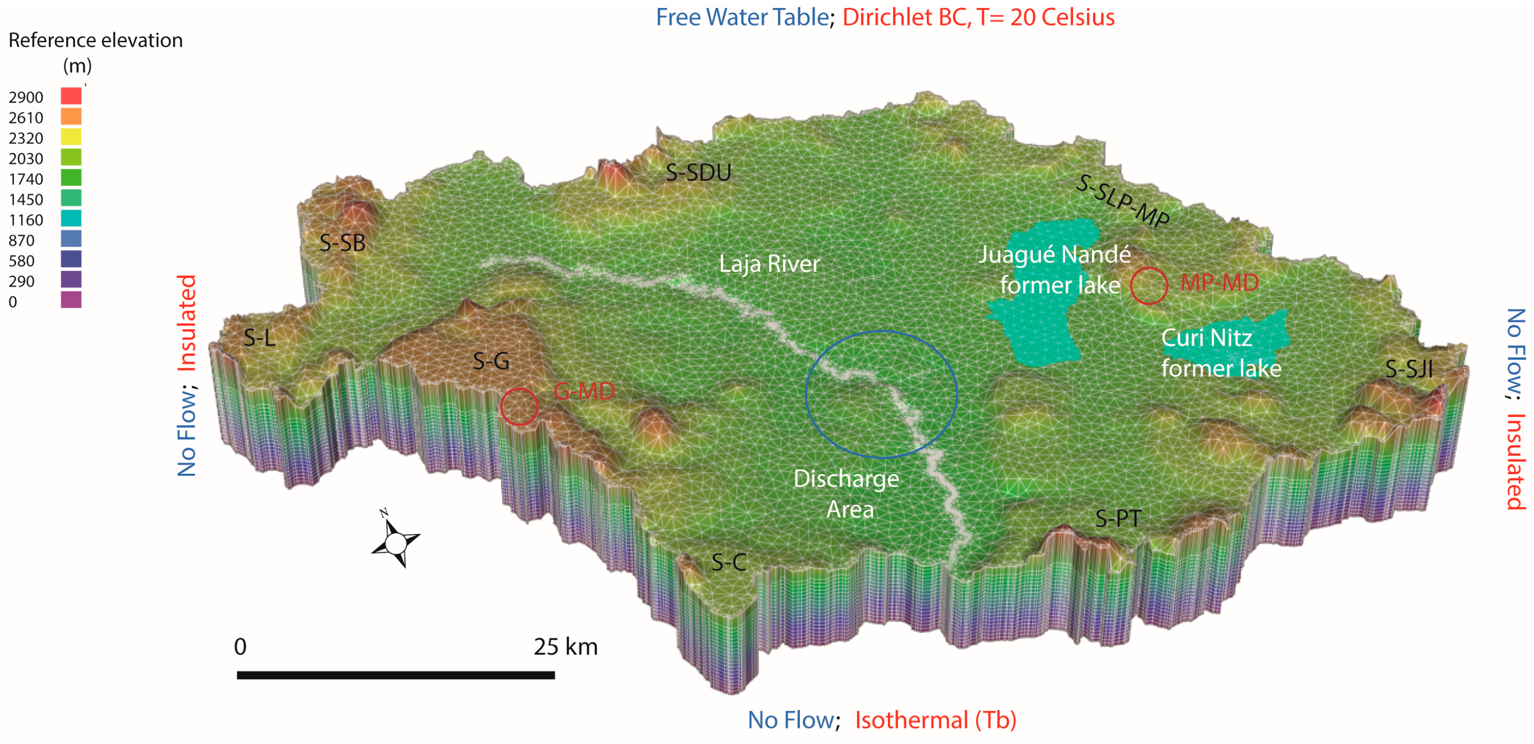
Figure 2. Domain of the Independence Basin showing the elevation of mountain massifs and the course of the La Laja River that runs northwest-to-south. Several features of the flow system are shown, including the main discharge area in the central part of the basin (blue circle) associated with saline soils, phreatophytes, and thermal springs. Boundary conditions for flow (blue) and heat (red) are indicated. The sites of two ancient lakes, Juagué Nandé and Curi Nitz, appear in cyan. The main sierras that delimit the IB are Guanajuato (S-G), Santa Bárbara (S-SB), San Diego de la Unión (S-SDU), San Luis de la Paz-Mineral de Pozos (S-SLP-MP), Dr. Mora (S-DMR), San José Iturbide (S-SJI), Picachos-Támbula (S-PT), and Codornices (S-C). Two important mining districts are circled in red: Guanajuato (MD-G) and Mineral de Pozos (MD-MP). Vertical exaggeration of the scale is 5:1.
Two shallow lakes (Juagué Nandé, Curi Nitz) existed until the second half of the 16th century in the eastern part of the IB, but were drained during the conquest. Curi Nitz remained as a wetland [2][3] (Figure 2). Pumping from the main aquifers began in the early 20th century with the drilling of the first wells. Extraction increased substantially in the early 1980s, causing a lowering of the water table, a temperature increase over time, and regional contamination of groundwater, with severe impacts for health and the environment [1]. While several studies of groundwater flow and water quality have been carried out in the IB, none have included a comprehensive analysis of the regional flow considering the effects of temperature. Numerous mathematical models have been applied to the study of artificial administrative aquifers since the 1980s, but they have relied on the assumed boundary conditions of the aquifers. Factors such as mountain massifs, the configuration of the water table in the mountains, and the hydraulic connections between mountains and the main aquifers have not yet been evaluated, despite the importance of understanding the long-term response of the basin and its aquifers to intense pumping and harmful solute migration.
2. Hydrogeology of the Basin
2.1. Geology
The IB is located in the vicinity of three geological provinces: the Sierra Madre Occidental, Trans-Mexican Neovolcanic Belt, and North American plate, where various types of rocks and sediments exist due to complex geological evolution. The lithological units that outcrop in the IB are divided into two large groups: basal complex and Cenozoic cover [4][5]. The former is composed of volcano-sedimentary rocks of Lower Cretaceous age related to the Guerrero Terrain, and a sequence of island arcs [6][7]. The latter has two members: (1) volcanic rocks of predominantly rhyolitic composition and sediments that date from the Eocene to the early Miocene, associated with the evolution of the Sierra Madre Occidental (SMOc); and (2) intermediate-to-mafic volcanic rocks and sediments with trace back to the late Miocene to late Pliocene [8][9][10].
Volcanic activity in the region has alternated with periods of intense erosion and sedimentation that filled tectonic depressions, forming the current granular aquifer in the central area. During the Cenozoic, the main structures were faults and fractures, products of extension which cut stratigraphic units that allow researchers to distinguish several faulting events that occurred from the Paleocene-Eocene to the Pliocene, and possibly into the Pleistocene [4][11]. The Basin is also at the limits of two geothermal provinces: the Central Intraplate Volcanism and Mexican Volcanic Belt (MVB) [12].
2.2. Hydrostratigraphy
From a hydrogeological perspective, there are two main aquifers, one fractured generally with volcanic rocks of rhyolitic and ignimbritic composition, and the other granular, made up of lacustrine and volcanoclastic deposits [1]. The fractured aquifer outcrops mainly in the mountains that delimit the basin and in Tertiary volcanic assemblages that extend underground. The granular aquifer covers the fractured aquifer inside the basin with average thicknesses of 100–200 m and, though only in four areas associated with rift valleys, 300–400 m. Approximately 80% and 20%, respectively, of existing wells are in the granular and fractured aquifers, which are exploited individually and in a mixed mode indicative of hydraulic continuity between them.
2.3. Natural Manifestations of Groundwater Conditions
Figure 2 shows the different types of evidence associated with the regional groundwater flow systems in the basin, such as lacustrine zones, springs, saline soils, and phreatophytic vegetation. Evidence is concentrated in two specific zones: (1) the eastern zone (San Luis de la Paz-Dr. Mora-San José Iturbide); and (2) the central-southeastern zone (Dolores Hidalgo-San Miguel de Allende).
In pre-Hispanic times, two important lakes — Juagué-Nandé and Curi-Nitz (Figure 2) — existed, both regulated by the Chichimecas (a First Nation People that inhabited north and lower-west Mexico) by means of dams [3]. Based on digital topographic information, the Juagué-Nandé Lake (now known as Laguna Seca [dry lake]) is delimited by the elevation of 1990 masl, while the lacustrine influence on the Curi-Nitz Lake (site of the La Cebada dam) extended to the town of Dr. Mora, formerly Charcas (i.e., accumulation of water on the ground [pond]) (Figure 2). Saline soils developed in two main areas: El Salitre, where the Curi Nitz Lake existed, and Tequisquiapan (place on the tequesquite (salt) river, or saltpeter) in the main area of groundwater discharge in the central area of the IB delimited by the area inside the blue circle (Figure 2).
The founding of major cities in the basin occurred in zones with springs (SF, SLP, SDU, SMA,) and areas with shallow water tables (SJI-DM). Important thermal springs have been described near the La Laja River, between the cities of SMA and DH, called Xoté, Montecillo, and Atotonilco (place of hot water) [2]. All these cities are in the main discharge zone in the central area of the basin. Numerous springs have been reported over time in mountainous areas, but most have disappeared.
2.4. Historical and Current Manifestations of Groundwater Conditions
The presence of a water table in the mountain massifs surrounding the IB is evident from the mining activity that has been ongoing since the 18th century, especially in the Mineral de Pozos and Guanajuato districts (Figure 2). In the late 19th century, many mines were flooded during a period when mining had been suspended due to Mexico’s War of Independence (1810–1821) [13][14]. Based on the depth of the flood levels and the elevation of the terrain, the position of the hydraulic head in the mountains was estimated in the range of 2200–2400 m. In the central area of the basin and the proximities of the La Laja River, various thermal groundwater anomalies are still observable in springs in the Atotonilco-Tequisquiapan discharge area, the site of numerous spas, and in the temperature of several wells near the basin.
2.5. Preliminary Water Budget
Three methods were applied to estimate the range of values for the groundwater budget in the basin: (a) infiltration rates from average precipitation; (b) base flow from total streamflow in the La Laja River based on old records; and (c) the evolution of water table decline due to groundwater extraction in 1950–2010. Annual average precipitation over a 50-year period was 477.6 ± 119.9 mm; evaporation was 1906.6 ± 167 mm and the aridity index was 0.2547 ± 0.0747 in the central area of the basin [15] and 850 mm in the Sierra de Guanajuato [16]. At the outlet from the basin, average rainfall was 497.9 mm and the potential evaporation above 2000 mm [17]. In a first stage of analysis, different infiltration rates were considered for both the mountainous areas and the lowlands. To include the effect of rainfall with the topography, various infiltration rates proportional to the elevation of the terrain were established using the range of precipitation.
Previous analyses of the regional groundwater flow in the Basin of Mexico (P = 600 mm–1200 mm) and the Amacuzac Basin (P = 800 mm–1500 mm), both southeast of the IB, found that a recharge of 30–50% of the average precipitation was representative for the hydrogeological study [18][19]. In the semi-arid environment of the IB, however, lower recharge rates are expected.
Total streamflow in the La Laja River, between 1970 and 2000, showed a general decline from 475 × 106 m3/a in 1971 (three years after construction of the Allende dam at the exit of the basin) to about 100 × 106 m3/a in 2000; this can be explained by the effects of groundwater extraction. Minimum baseflow represented 20 × 106 m3/a (5%) to 34 × 106 m3/a (13%) of total streamflow in the 1970s [17]. These baseflow values may be underestimated because they were considered as the minimum streamflow rates and were not calculated by separation of the unitary hydrographs.
Groundwater extraction in the basin began in the 1950s. Evidence of a significant decline in the water table appeared in the late 1970s as groundwater extraction increased from about 300 × 106 m3/a to 412 × 106 m3/a in 1980, with significant regional declines in the water table, which signal that the safe yield was exceeded and that over extraction from the aquifer had begun (Figure 3).
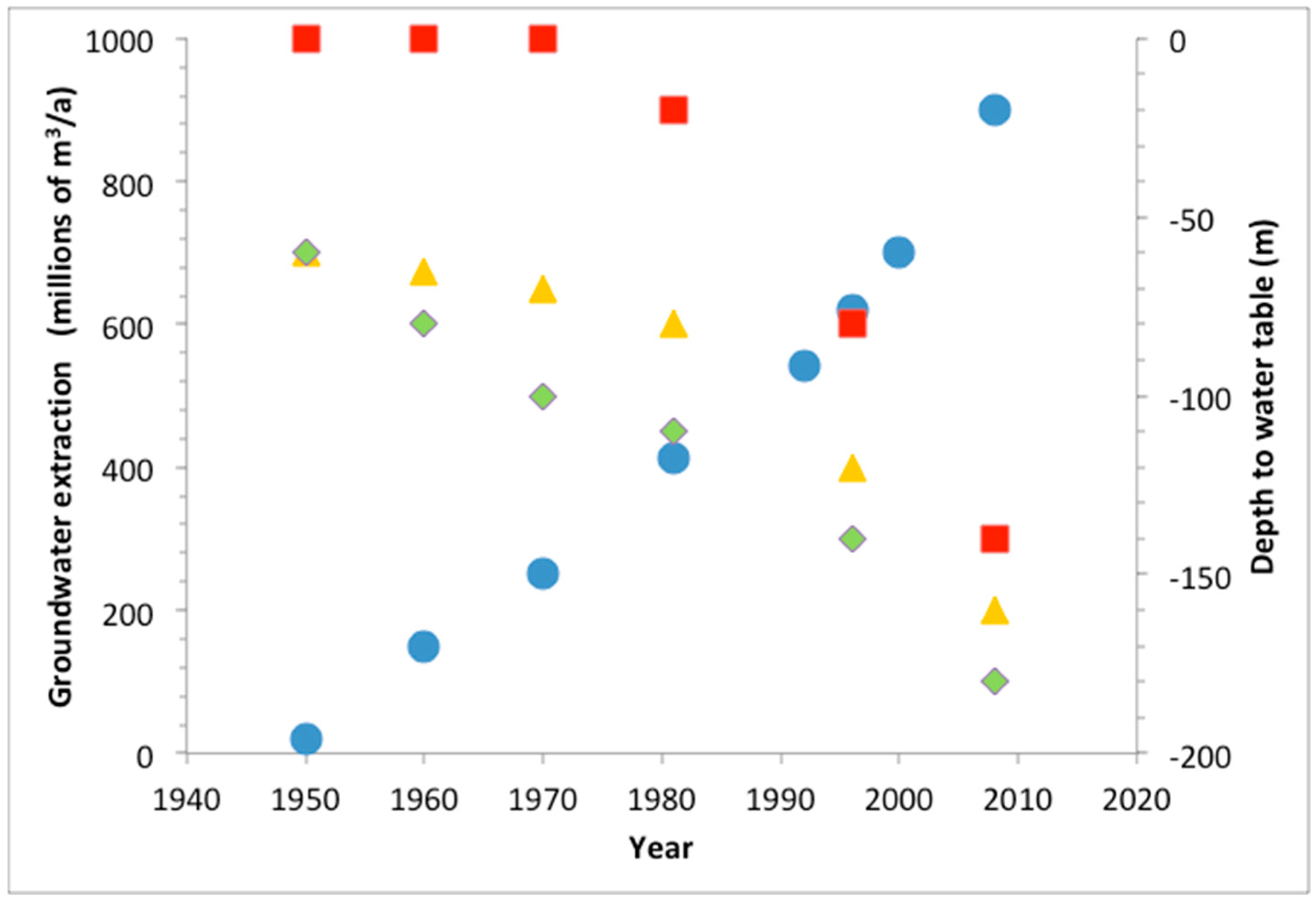
Figure 3. Evolution of groundwater extraction and annual decline of the water table at different places in the IB. Data are based on several hydrogeological studies conducted since the 1970s [1]. Blue circles represent the evolution, of groundwater extraction over time with an approximately exponential trend; the squares, triangles, and rhombuses show the decline of the water table at several locations in the aquifer. The zones with historically shallow water tables are visible near the ancient lakes and discharge areas (red squares).
These three ways of approaching the water budget in the IB give an idea of the limits of the modeling analysis in terms of recharge and the hydrogeological conditions of the domain.
References
- Ortega-Guerrero, M.A. Occurrence, distribution, hydrochemistry and origin of arsenic, fluoride and other trace elements dissolved in groundwater at basin scale in central Mexico. Rev. Mex. Ciencias Geol. 2009, 26, 143–161. https://doi.org/10.22201/cgeo.20072902e.2009.1.1685.
- González, P. Geografía Local del Estado de Guanajuato, 1st ed.; Ediciones La Rana: Guanajuato, Mexico, 1904; p. 691.
- Tarquín, A.G. Leyendas y Tradiciones de la Tribu Chichimeca; Ediciones del Gobierno de Guanajuato: Guanajuato, Mexico, 1963; p. 135.
- Nieto-Samaniego, A.F.; Macias-Romo, C.; Alaníz-Álvarez, S.A. Nuevas Edades Isotópicas de la Cubierta Volcánica Cenozoica de la Parte Meridional de la Mesa Central; Revista Mexicana de Ciencias Geológicas: Guanajuato:, Mexico, 1996; Voume 13; pp. 117–122.
- Pérez-Venzor, J.A.; Aranda-Gómez, J.J.; McDowell, F.W.; Solorio-Munguia, J.G. Bosquejo de la Evolución Geológica del Volcán Palo Huérfano; Revista Mexicana de Ciencias Geológicas: Guanajuato, Mexico, 1996; Volume 13; pp. 174–183.
- Chiodi, M.; Monod, O.; Busnardo, R.; Gaspard, D.; Sánchez, A.; Yta, M. Une discordance ante albienne datée par une faune d’ammonites at brachiopodes de type Tèthysien au Mexique Central. Geobios 1988, 21, 125–135.
- Elías–Herera, M.; Ortega-Gutierrez, F. The Early Cretaceous Arperos oceanic basin (western Mexico). Geochemical evidence for an aseismic ridge formed near a spreading center. Tectonophysics 1998, 292, 321–326.
- Nieto-Samaniego, A.F.; García-Dobargones Bueno, J.E.; Aguirre-Maese, A.L. Interpretación Estructural de Los Rasgos Ge-omorfológicos Principales de la Sierra de Guanajuato: Universidad Nacional Autónoma de México. Rev. Inst. de Geol. 1992, 10, 1–5.
- Aranda-Gómez, J.J.; Aranda-Gómez, J.M.; Nieto-Samaniego, A.F. Consideraciones acerca de la evolución tectónica durante el Cenozoico de la Sierra de Guanajuato y la parte meridional de la Mesa Central. Rev. Inst. Geol. 1989, 8, 33–56.
- Aranda-Gómez, J.J.; McDowell, F.W. Paleogene extension in the southern Basin and Range Province of Mexico: Syn-depositional tilting of the Eocene red beds and Oligocene volcanic rocks in the Guanajuato mining district. Int. Geol. Rev. 1998, 40, 116–134.
- Labarthe-Hernández, G.; Tristán-González, M.; Aranda-Gómez. J.J. Revisión Estratigráfica del Cenozoico en la Parte Central del Estado de San Luis Potosí; Universidad Autónoma de San Luis Potosí, Instituto Geológico y Metalúrgico: Folleto Técnico, Mexi-co, 1982; Volume 85; p. 208.
- Prol-Ledesma, R.M.; Morán-Centeno, D. Heat flow and geothermal provinces in Mexico. Geothermics 2019, 78, 183–200.
- Martínez-Roldán, N.; Goytia-Goyenechea, L. Mining trace in the city of Guanajuato (México) between the XVI-XIX centuries: Urban morphology and planimetry in the archive of Indias in Sevilla (Spain). Rev. Contexto. Sept. 2020, XIV, 35–49.
- Consejo de Recursos Minerales. Ficha de Inventario de Yacimientos Minerales, Estado de Guanajuato. 2002. Available online: https://mapserver.sgm.gob.mx/InformesTecnicos/InventariosMinerosWeb/A1103PAPJ0003_01.pdf (accessed on 12 november 2021).
- Aguilar-García, R.; Ortega-Guerrero, M.A. Analysis of the dynamics of water in the unsaturated zone in a soil subject to conservation practices: Implications for aquifer management and adaptation to climate change. Rev. Mex. De Cienc. Geológi-cas 2017, 34, 91–104. https://doi.org/10.22201/cgeo.20072902e.2017.2.430.
- Martínez-Arredondo, J.C.; Jofre Meléndez, R.; Ortega Chávez, V.M.; Ramos Arroyo, Y.R. Descripción de la variabilidad cli-mática normal (1951–2010) en la cuenca del río Guanajuato, centro de México. Acta Univ. 2015, 25, 31–47. https://doi.org/10.15174/au.2015.799.
- Palacios-Vélez, E.; López-López, C. La Sobreexplotación de Las Cuencas Hidrológicas: El Caso De La Cuenca Del Río de La Laja, Guanajuato; En Cotler, H., Ed.; El Manejo Integral de Cuencas en México: México, Secretaría del Medio Ambiente y Recursos Naturales, Instituto Nacional de Ecología: Mexico City, Mexico, 2004; pp. 117–131.
- Ortega, A.; Farvolden, R.N. Computer analysis of regional groundwater flow and boundary conditions in the Basin of Mexi-co. J. Hydrol. 1989, 110, 271–294.
- Morales-Casique, E.; Guinzberg-Belmont, J.; Ortega-Guerrero, A. Regional groundwater flow and geochemical evolution in the Amacuzac River Basin, Mexico. Hydrogeol. J. 2016, 24, 1873–1890. https://doi.org/10.1007/s10040-016-1423-x.
- Ortega-Guerrero, M.A.; Castellanos, J.Z.; Aguilar, G.R.; Vázquez-Alarcón, A.; Alanis, R.E.; Vargas, C.C.; Urrutia, E.F. A Conceptual Model for Increases of Sodium, Sar, Alkalinity and ph at the Independence Aquifer in Guanajuato, Mexico; TERRA Lati-noamericana: Mexico City, Mexico, 2002; Volume 20; pp. 199–207. Available online: https://www.redalyc.org/articulo.oa?id=57320213 (accessed on 10 September 2021).
More
Information
Subjects:
Water Resources
Contributor
MDPI registered users' name will be linked to their SciProfiles pages. To register with us, please refer to https://encyclopedia.pub/register
:
View Times:
1.2K
Entry Collection:
Environmental Sciences
Revisions:
2 times
(View History)
Update Date:
05 May 2022
Table of Contents


Notice
You are not a member of the advisory board for this topic. If you want to update advisory board member profile, please contact office@encyclopedia.pub.
OK
Confirm
Only members of the Encyclopedia advisory board for this topic are allowed to note entries. Would you like to become an advisory board member of the Encyclopedia?
Yes
No
${ textCharacter }/${ maxCharacter }
Submit
Cancel
Back
Comments
${ item }
|
${ item.createdUser.fullName }
${ item.createdAt }
${ item.vote }
${ item.reply }
Delete
${ reply.createdUser.fullName }
${ reply.createdAt }
${ reply.vote }
Delete
There is no reply to this comment~
${ item.replyTextCharacter }/${ item.replyMaxCharacter }
Submit
Cancel
More
No more~
There is no comment~
${ textCharacter }/${ maxCharacter }
Submit
Cancel
${ selectedItem.replyTextCharacter }/${ selectedItem.replyMaxCharacter }
Submit
Cancel
Confirm
Are you sure to Delete?
Yes
No