Your browser does not fully support modern features. Please upgrade for a smoother experience.
Submitted Successfully!
 +1 credit
Thank you for your contribution! You can also upload a video entry or images related to this topic.
For video creation, please contact our Academic Video Service.
| Version | Summary | Created by | Modification | Content Size | Created at | Operation |
|---|---|---|---|---|---|---|
| 1 | Amjad Masood | + 2901 word(s) | 2901 | 2022-02-15 03:11:47 | | | |
| 2 | Muhammad Atiq Ur Rehman Tariq | Meta information modification | 2901 | 2022-02-15 11:41:52 | | | | |
| 3 | Jason Zhu | Meta information modification | 2901 | 2022-02-16 02:29:04 | | | | |
| 4 | Jason Zhu | Meta information modification | 2901 | 2022-02-16 02:32:56 | | | | |
| 5 | Jason Zhu | Meta information modification | 2901 | 2022-02-18 10:49:33 | | |
Video Upload Options
We provide professional Academic Video Service to translate complex research into visually appealing presentations. Would you like to try it?
Cite
If you have any further questions, please contact Encyclopedia Editorial Office.
Masood, A.; Tariq, M.A.U.R. Satellite-Based Groundwater Monitoring. Encyclopedia. Available online: https://encyclopedia.pub/entry/19449 (accessed on 16 July 2026).
Masood A, Tariq MAUR. Satellite-Based Groundwater Monitoring. Encyclopedia. Available at: https://encyclopedia.pub/entry/19449. Accessed July 16, 2026.
Masood, Amjad, Muhammad Atiq Ur Rehman Tariq. "Satellite-Based Groundwater Monitoring" Encyclopedia, https://encyclopedia.pub/entry/19449 (accessed July 16, 2026).
Masood, A., & Tariq, M.A.U.R. (2022, February 15). Satellite-Based Groundwater Monitoring. In Encyclopedia. https://encyclopedia.pub/entry/19449
Masood, Amjad and Muhammad Atiq Ur Rehman Tariq. "Satellite-Based Groundwater Monitoring." Encyclopedia. Web. 15 February, 2022.
Copy Citation
Satellite is an effective technology to assess water storages remotely through remote sensing and geographic information system (RS and GIS), which are very useful tools in groundwater exploration mapping. They provide inputs to assess the total groundwater resources in a region and for the selection of suitable sites for drilling or artificial recharge.
Satellites
groundwater
GRACE
Water resources
1. Most Common Satellites
The first application of satellite data for earth monitoring, including hydrological studies, started back in 1957 [1][2]. Satellite data of LANDSAT, MODIS, and other similar satellites (Sentinel-2, SPOT etc.) have been used for the assessment of cryosphere (snow and glaciers), soil water, surface water, groundwater, evaporation, and other constituents of the global hydrologic system [3][4][5][6].
The Moderate Resolution Imaging Spectrometer (MODIS) data are used to help improve the understanding of global dynamics and processes that occur on the land, in the oceans, and in the lower atmosphere [7]. These specifically include total precipitable water, cloud, atmospheric profiles, land cover, evapotranspiration, water mask, ocean products, snow, glaciers, and sea ice cover [8][7][9][10]. MODIS is a sensor that operates on the two satellites, i.e., Terra and Aqua, which were launched by NASA in 1999 and 2002, respectively [11]. Terra passes around the earth from north to south across the equator in the morning, whereas the Aqua satellite passes from south to north in the afternoon. In this way, both satellites view the entire Earth’s surface every one to two days, obtaining data in 36 spectral bands. The spatial resolution of MODIS data is 250 m, 500 m, and 1 km [12]. Relatively coarse resolution is its limitation; however, its benefit is its open-access availability.
MODIS satellite does not assess groundwater resources directly; however, it helps to improve the different model inputs for groundwater modeling. An example consists of using the Nation-wide Groundwater Recharge Model (NGRM) for New Zealand. It uses MODIS-derived evapotranspiration and vegetation satellite data, available rainfall dataset, elevation, soil, and geology, etc., and this research shows that with minor model adjustments and use of improved input data, large-scale models and satellite data can be used to derive rainfall recharge estimates for local scales. The estimated recharge of the NGRM model compares well to most local and regional data and recharge models [13].
Landsat satellite is also a helpful tool for groundwater assessment; however, it has a high resolution (i.e., 30 m) [14] relative to MODIS. Its images are also freely available for research purposes, which is a great benefit. The Landsat Program is a continuous Earth-observing satellite mission, which is jointly managed by NASA and the U.S. Geological Survey. It started in 1972 with Landsat 1 and has been continued throughout the following four decades with Landsat 2, 3, 4, 5, 6, 7, and 8, and the last one (Landsat 9) launched in mid-2021 [15].
Landsat data collect spectral information from the earth’s surface. Landsat data have evolved as a valuable resource of agriculture, land use, water resources, forestry, and natural resource investigation along with the understanding of existing circumstances of land changes in freshwater supplies [14][16][17][18].
The European Space Agency (ESA) under the Copernicus Program provides Sentinel-2 with temporal and spatial (10–20 m) resolution of 5 days and 10–20 m, respectively, which has opened new vistas for many applications for having higher resolution than both MODIS and Landsat [19][20][21][22][23][24][25][26]. Sentinel-2 is a multispectral operational imaging mission for worldwide land observation. It provides the data on soil, water, and vegetation cover for land, inland waterways, and coastal areas [27]. Dubois et al. [28] used Sentinel-2 data to estimate the groundwater withdrawals in the Maghreb area. Some other studies also estimated groundwater needs indirectly via determining irrigation requirements for agricultural production [22][29].
Interferometric Synthetic Aperture Radar (INSAR) makes high-density measurements over large areas by using radar signals through Earth-orbiting satellites for measuring the variations of land surface elevation at higher resolution and spatial detail [30]. With INSAR, the variations in land surface elevation, the spatial extent, and the magnitude of deformation that is linked with fluid abstraction and natural hazards (landslides, volcanoes, earthquakes) are measured effectively. By utilizing synthetic aperture radar satellite data through InSAR techniques, ground deformation is assessed [31][32]. For local or regional scales, InSAR maps millimeter-scale displacements of the Earth’s surface with radar satellite measurements. It helps to survey remote sites quickly by measuring areas (thousands of kilometers) and attaining a spatial resolution of around 20 m.
There can be a combination of multiples data sources and different techniques to find a particular parameter of groundwater. Srivastava and Bhattacharya [33] utilized IRS-LISS III (Indian Remote Sensing 1D Linear Imaging Self-Scanning Sensor 3) with TM/ETM + (Landsat Thematic Mapper/Enhanced TM) digital data and SRTM DEM (Shuttle Radar Topographic Mission Digital Elevation Models) to create multiple models. These include geomorphology, lithology, land uses, soil, lineament, river gradient, drainage density, and slope maps for detailed groundwater modeling.
2. GRACE Satellite Data
The direct measurement of water column remained unsolved till 2002, when Gravity Recovery and Climate Experiment (GRACE), consisting of two satellites, was launched. These two satellites were upgraded to GRACE-FO in 2018. The combined task of the U.S. and German space agencies aims for detailed measurements of Earth’s gravity field changes. These have revolutionized the explorations about Earth’s water reservoirs over land, ice, and oceans along with earthquakes and crustal deformations. The data of this project are free for research and management purposes. GRACE offers monthly, vertically combined estimates of Terrestrial Water Storage (TWS) anomalies (departures from the long-term mean) at a coarse spatial resolution of about 300 km. TWS is comprised of groundwater, soil water, surface water, snow, and ice. GRACE estimations are used to assess the groundwater-depletion rates throughout the world [34]. Although the resolution of this satellite is coarse, it is very useful for the large basins on a regional or global scale.
2.1. GRACE Products
The data obtained from the GRACE provide the information about the gravity anomalies. It needs extensive processing to extract groundwater-related direct information. The GRACE data can be classified into three stages/levels. The raw data, collected from satellites (Level 0), is calibrated and time tagged in a non-destructive (or reversible) sense and then labeled as Level 1A. Level 1A data products are not disseminated directly to the public. The data then undergo extensive and irreversible processing and are transformed to clean data products, labeled as Level 1B. These products include the inter-satellite range, range-rate, range-acceleration, the non-gravitational accelerations from each satellite, the pointing estimates, the orbits, etc. The Level 1B products are processed to produce the monthly gravity field estimates in form of spherical harmonic coefficients. These estimates are labeled Level 2. Occasionally, several months of data are combined to produce an estimate of the mean or static gravity field. After validation, all Level 2 and associated Level 1B products are released to the public.
GRACE Level 3 data represent monthly land-mass grids that possess terrestrial anomalies because of aquifers, snow covers, and river basins, etc. [35]. From the GRACE project data products, many GRACE users have put together the resources to generate and distribute value-added (or Level 3) products [36]. For the ease of users who would prefer to access GRACE data products as mass anomalies (for example water layer), some standardized products and tools are available from other sources, which are called Level 3 Data Products [37]. Figure 1 describes the GRACE data levels, processing, and the characteristics of these products.
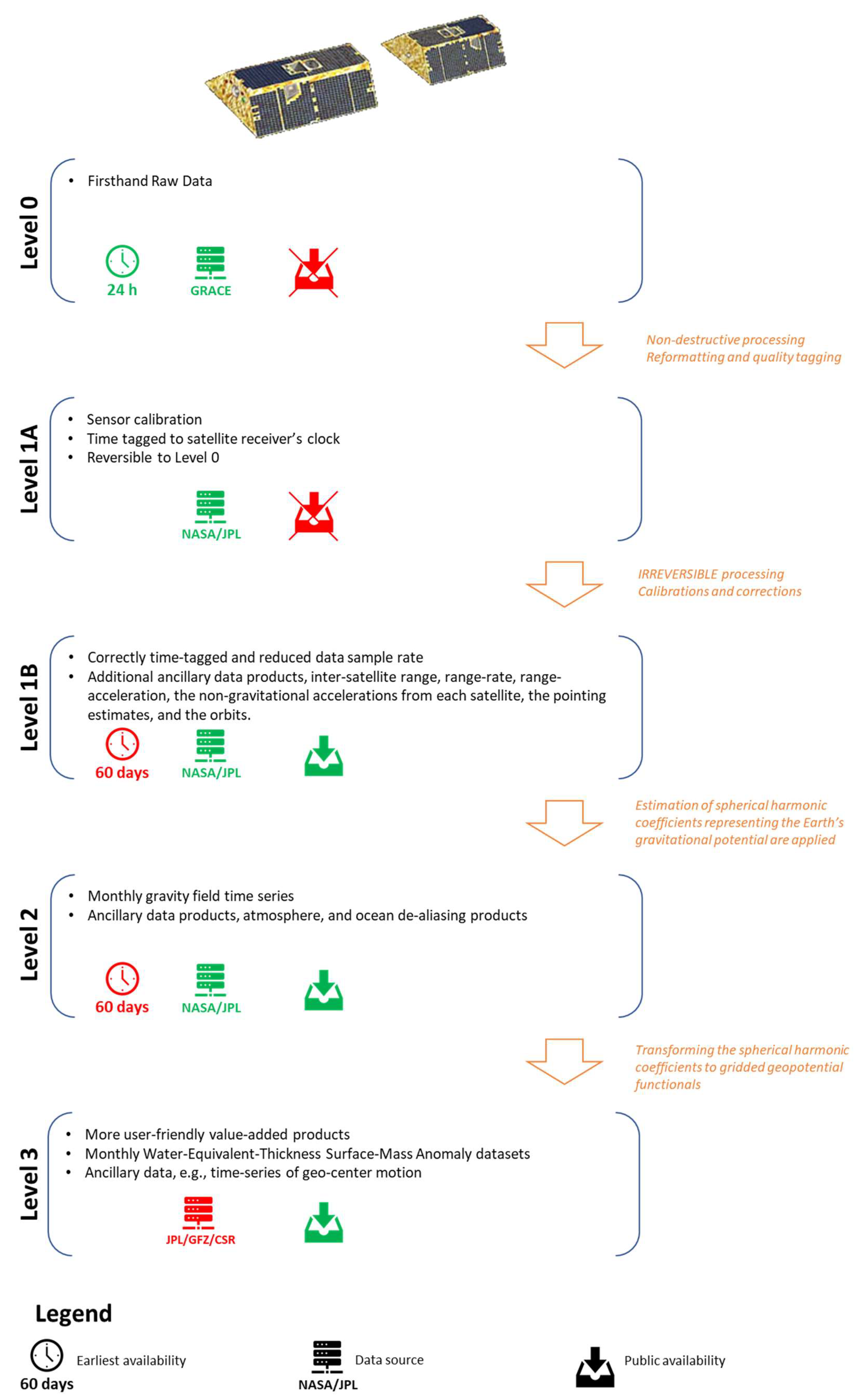
Figure 1. GRACE Satellite Data Levels, characteristics, and processing.
Spherical harmonic (SH) (Level 2) and mascon (Level 3) solutions are the two main GRACE products used for the estimation of TWS. Both techniques have successfully been used in the retrieval of time-varying gravity fields from GRACE. For SH products, filtering and leakage corrections are required to reduce the noise, while no such correction is required for the mascon solutions. The capability of SH and mascon solutions to determine basin level mass variation is computed with an assessment of how the noise and errors are handled, which are inherent in GRACE solution. Although mascon solutions have an edge over the SH by avoiding leakage correction, the performance of SH for local scales is better than the mascon if corrections are applied correctly.
Leakage error is one of the many GRACE error constituents (for example, measurement and post-processing error). Generally, a leakage adjustment is needed to recover biases. The most extensively used approach is forward modeling, which uses a priori information (generally from global model simulations or in situ observations) to mimic the GRACE data processing techniques. Uncertainties of GRACE data is another main issue. Detailed analysis of uncertainties is important to achieve reliable and optimized products for obtaining TWS changes globally. For this purpose, different statistical techniques/approaches are used. For example, to enumerate uncertainties in the changes of TWS in GRACE observations, the three-cornered hat technique is in practice. Amid all other TWS change products, the BMA-based changes in TWS demonstrate the maximum consistency using with the WGHM output [38]. Empirical Orthogonal Function decomposition technique can be used to show detailed patterns of TWS variations annually and seasonally to see the long-term trends [38]. Additionally, Monte Carlo simulation framework is effective for reduction of uncertainty and improved parameter estimation while using GRACE in the calibration of Land Surface Models (LSM) parameters [39][40][41].
2.2. Estimation of Groundwater Storage (GWS)
Due to absence of long observational data and the sparse spread of monitoring wells, satellite-based observations of groundwater-storage variations through the GRACE satellite are often used to estimate the groundwater-storage changes [42][43][44]. Terrestrial water storage includes all landforms of water available to an area. It includes groundwater, surface water and canopy water, soil moisture, and snow and is a main component of the global and continental hydrologic cycle. Groundwater-storage (GWS) changes are acquired from TWS through deducting soil moisture, surface water, canopy water, and snow water equivalent data gained from GLDAS or with any other dataset [45][46][47][48]. Figure 2 explains the components of freshwater storage and processes. The same is explained in the following Equations:


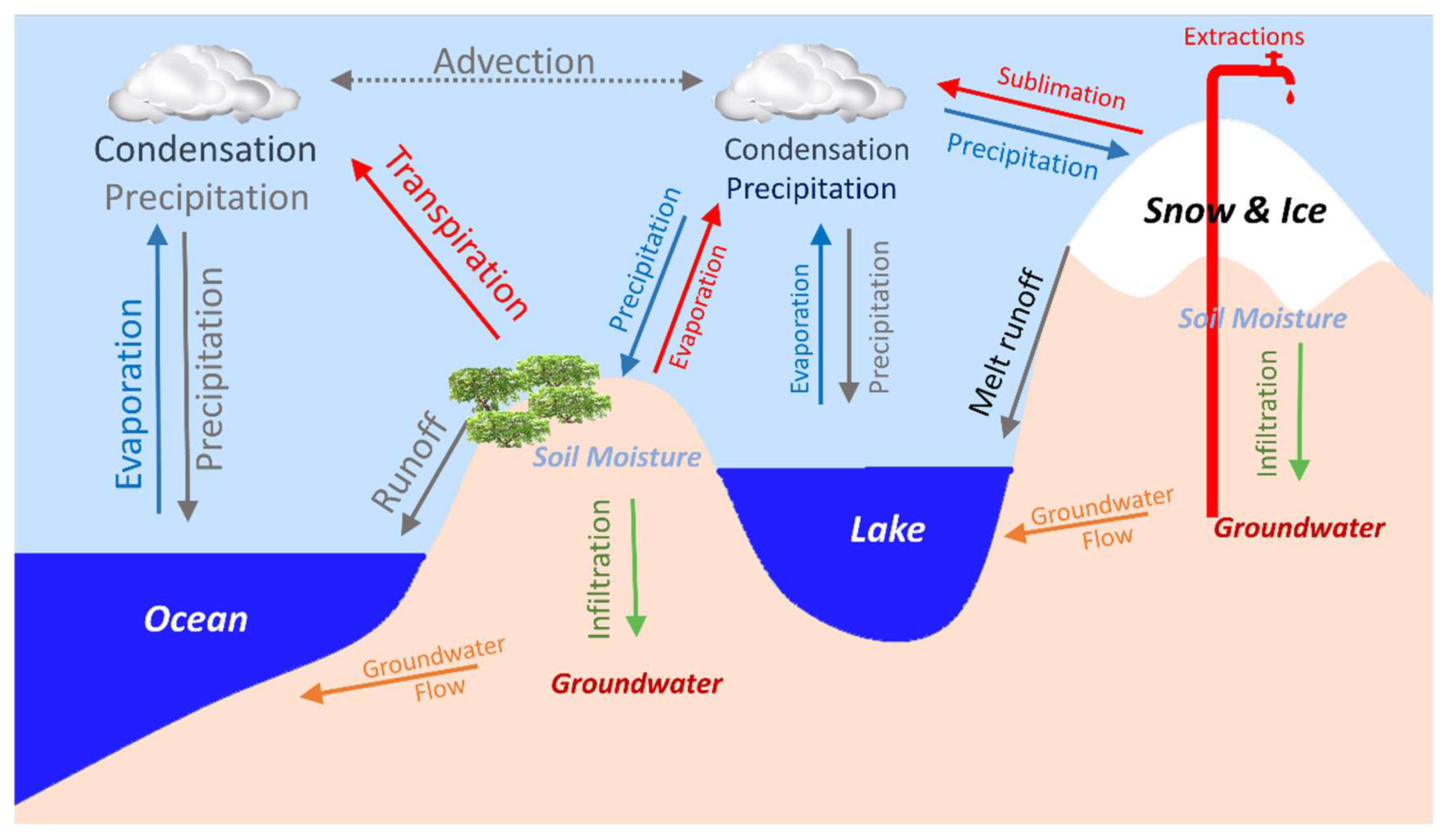
Figure 2. GRACE based total water storage variations are a composite of various continental water storage compartments.
Since 2002, the GRACE has supplied a highly valued dataset, which allows the study of TWS over large river basins globally. Shamsudduha et al. [49] used GRACE datasets for a long time period and found that for the recent time period (2003 to 2007), groundwater-storage changes correlate well with in situ borehole records in the Bengal Basin in Bangladesh. For the Indus Basin, the variation in groundwater storage at numerous spatial scales has been studied by Iqbal et al. [50] with GRACE data. They found that the groundwater storage changes through GRACE-based estimation is reasonably sufficient for the provision of monthly groundwater-storage changes.
Variations in TWS can be acquired through the GRACE data. After the changes in groundwater, the variation of soil moisture is normally the highest factor in TWS changes and intermediate zone storage [51]. Strassberg et al. [52] found a robust link between the sum of soil moisture and groundwater storage with TWS by means of GRACE data. Before GRACE satellite, estimates of TWS changes were used to derive from the in situ data of soil moisture and snow. These approaches cover analyzing the variations in groundwater, soil water, surface water, and snow through utilizing a long time series [51].
Since the GRACE satellite was launched in 2002, a great deal of researchers has conducted the studies of groundwater using GRACE satellite data. According to the research articles published in various journals (source: https://scholar.google.com/, dated 18 January 2022), an annual frequency graph of articles has been developed to envisage the work carried out using GRACE data (refer to Figure 3).
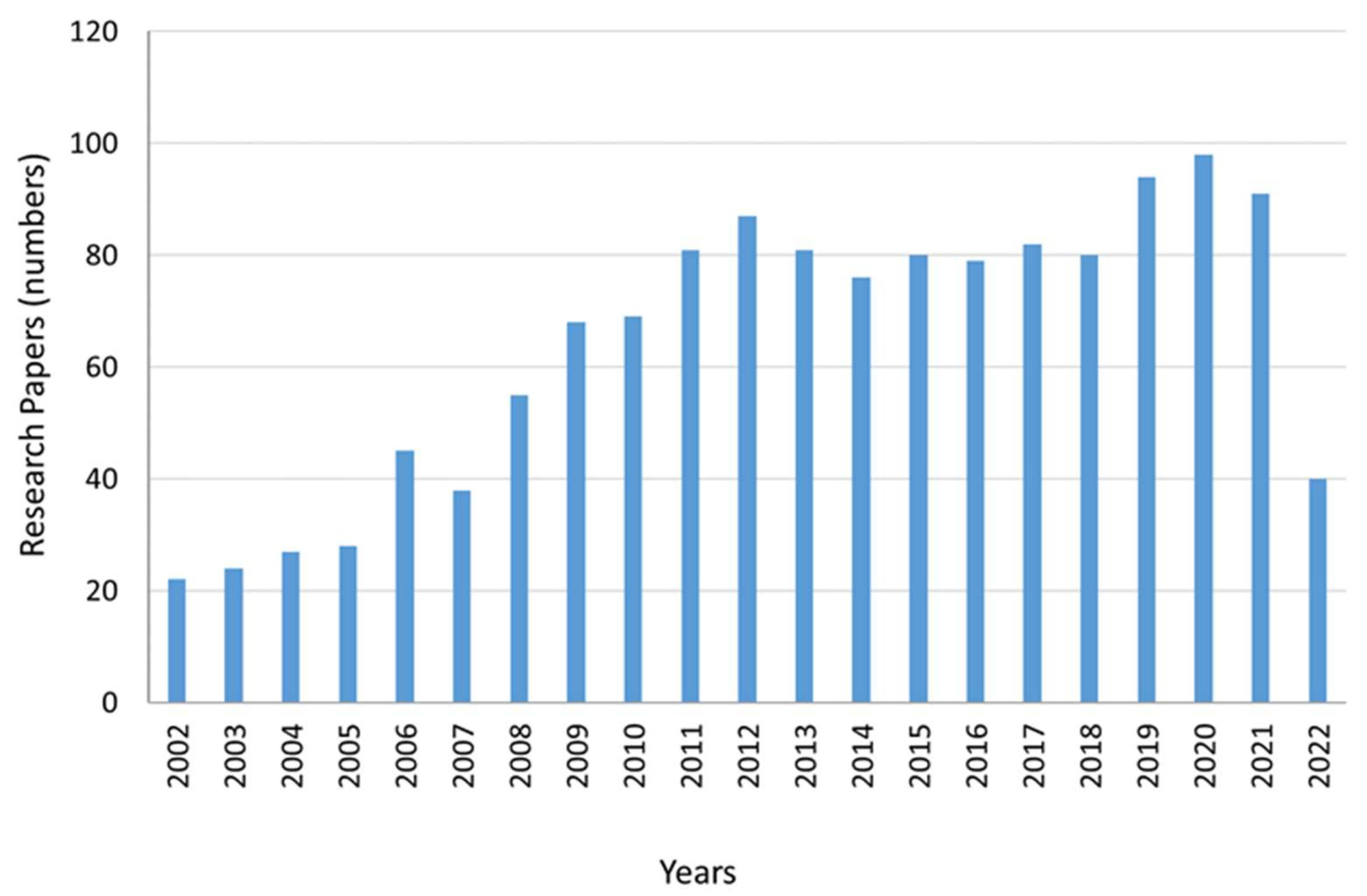
Figure 3. Annual Article Frequency on GRACE.
2.3. GRACE Applications
GRACE provides useful information about global groundwater depletion. The shallow GWS declines faster than the deep GWS [53]. Globally, GRACE could be the only hope for the assessment of groundwater reduction [48]. GRACE data are useful for the estimation of regional groundwater monitoring on monthly to seasonal scale. Yeh et al. [54] confirmed the ability of GRACE to simulate regional groundwater-storage changes from monthly to seasonal scale for an area of about 200,000 km2 area in Illinois. It also provides reasonable results for the heterogeneous GWS variations as observed by Huang et al. [53]. Döll et al. [55] conducted groundwater storage monitoring for the Mississippi Basin. However, the study failed to obtain reliable results to monitor the total water storage due to water withdrawals at the whole scale of the basin. GRACE data were applied in global hydrological investigations, including water storage change evaluation, groundwater and evapotranspiration retrieving, drought analysis, and glacier response to global change [56]. In another study, complementary relationship (CR) approach was used to assess the evapotranspiration and a water balance method to estimate the runoff and base flow in the Conterminous United States (CONUS), which demonstrates how to use it with limited parameterization and datasets [57].
There are many GRACE-based studies of groundwater that showed substantial aquifer depletion for the large regions, for example, the North China, the northwest India, the Middle East, the Murray Darling Basin of Australia, and California’s Central Valley aquifers of the USA [42][44][58][59][60][61]. The shrinking phenomena of groundwater-fed lakes have also been monitored through GRACE and GLDAS [8]. Sun et al. [62] developed a method for estimation of aquifer storage parameters (specific yield and storability) utilizing the GRACE data for the connected aquifers of Edwards-Trinity Plateau and Pecos Valley in central Texas. Frappart and Ramillien [63] also found that these data were used to evaluate the parameters; the specific yield, for example, is used to relate groundwater level to storage or to describe the indices of groundwater depletion and stress. In another GRACE-GLDAS study, it was found that high consistency exists between GRACE observations and changes in water wells [64].
2.4. Additional Computational Tools
For groundwater management, the usage of GRACE data at a local scale has been inadequate due to in-built uncertainties in GRACE data and problems in disintegrating several TWS components.
Artificial Neural Network (ANN) models can be developed to foresee the variations of groundwater levels directly by means of a gridded GRACE product and other openly existing hydro-meteorological datasets. ANN is used as a statistical downscaling method, which is extensively used in streamflow projecting and management of water resources [65][66][67][68][69][70][71]. A trained ANN model is comparatively strong to data noise and is quite suitable to support real-time decision making [72][73]. Ensemble ANN models can be utilized to forecast monthly and seasonal groundwater-level changes for various wells situated in certain areas.
Because of the GRACE data, the ANN models forecast water-level variations instead of absolute water levels [73]. By combining GRACE, TRMM, and GLDAS, ANN predicts and evaluates groundwater drought [74]. Gemitzi et al. [75] used ANN to perform statistical downscaling of GRACE data using local meteorological data. A typical application process of ANN is shown in Figure 4.
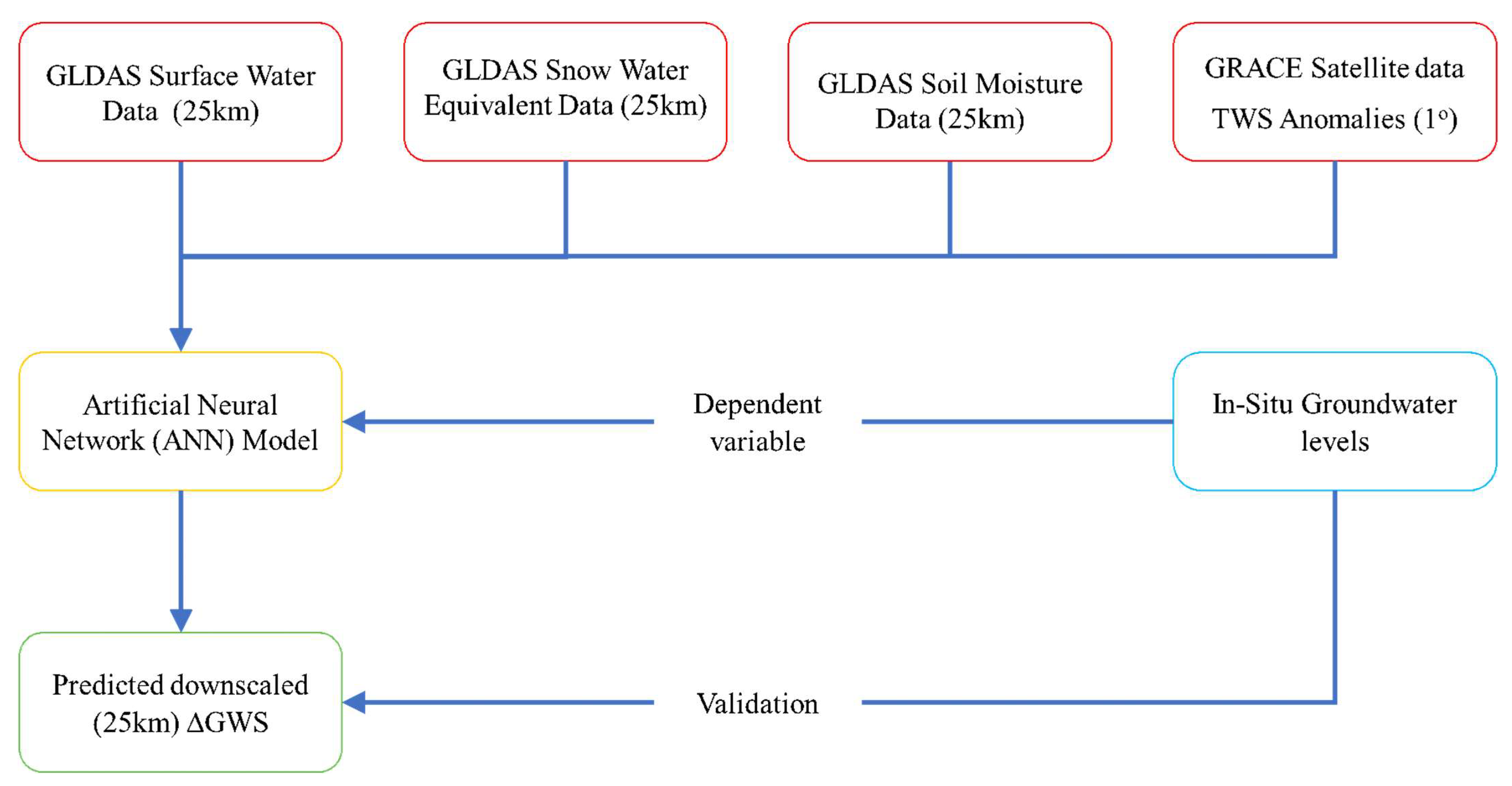
Figure 4. Predicted downscaled GRACE-GLDAS GWS changes with ANN.
Srivastava and Bhattacharya integrated numerous thematic plots on the GIS platform based on Saaty’s Analytical Hierarchy Process (AHP) with the Groundwater Potential Index (GWPI) values (0.175 to 0.940) to produce a good match with the resistivity and pumping test data [33]. Similarly, AHP was used by Mallick et al. [76] to find the most important contributing features to delineate the groundwater potential zones [77].
3. Supporting Terrestrial Modeling Systems
To monitor the other constituents of terrestrial water storage, for example, soil water, surface water, snow and ice water, canopy water, and groundwater, separately, some system is required to address this aspect, which was fulfilled by upgrading the GRACE system. This can be done with Global Land Data Assimilation System (GLDAS) and WaterGAP Global Hydrological Model (WGHM), which help GRACE to disintegrate the TWS into its required water component. For example, TWS disintegrates with help of these models to give groundwater anomalies.
3.1. Global Land Data Assimilation System (GLDAS)
The Global Land Data Assimilation System (GLDAS) is a worldwide, high-resolution, offline terrestrial modeling system that integrates satellite and ground-based observations to produce optimum fields of land surface conditions and fluxes in near-real time.
It produces a sequences of worldwide land surface conditions (for example, soil moisture and surface temperature) and fluxes (for example, evaporation and sensible heat flux) products that were simulated by four Land Surface Models (LSM), that is, VIC, Mosaic, CLAM, and Noah.
Several current and proposed weather and climate prediction, water resources applications, and water-cycle investigations rely on GLDAS output. GLDAS runs globally and on user defined domains at resolutions ranging from 2.5° to 1 km. The GRACE and GLDAS simulations provide precise and reliable datasets that are used to describe the variations of groundwater storage regionally [78]. The assessed groundwater variations by GRACE-GLDAS are usually in line with in situ observations [39][38][40][53][54][78][79].
3.2. WaterGAP Global Hydrological Model (WGHM)
WGHM calculates timeseries of surface and subsurface runoff, groundwater recharge, and river flows along with water storage variations in canopy, snow, soil, groundwater, rivers, lakes, and wetlands. Therefore, it can quantify the whole water resources along with the groundwater resources. Institute of Physical Geography (IPG) developed WGHM to provide freshwater fluxes with storage data on the land surface globally [80][81]. The spatial resolution of the model is 0.5° × 0.5°, and computations are carried out on daily basis, whereas the output is analyzed on a monthly time step. The WGHM considers the human-induced water consumption along with the daily groundwater simulations [80]. Figure 5 explains the possible approaches to incorporated GLDAS and WGHM data to obtain GWS from the GRACE data. In this figure, it can be seen that TWS is obtained through GRACE satellite, whereas both GLDAS and WGHM give surface water, soil moisture, snow water equivalent, and groundwater storage. Final groundwater storage profiles are obtained through the interaction of GRACE with GLDAS and GRACE with WGHM, which can be compared with in situ groundwater measurements based upon the statistical selection criteria as given in the figure.
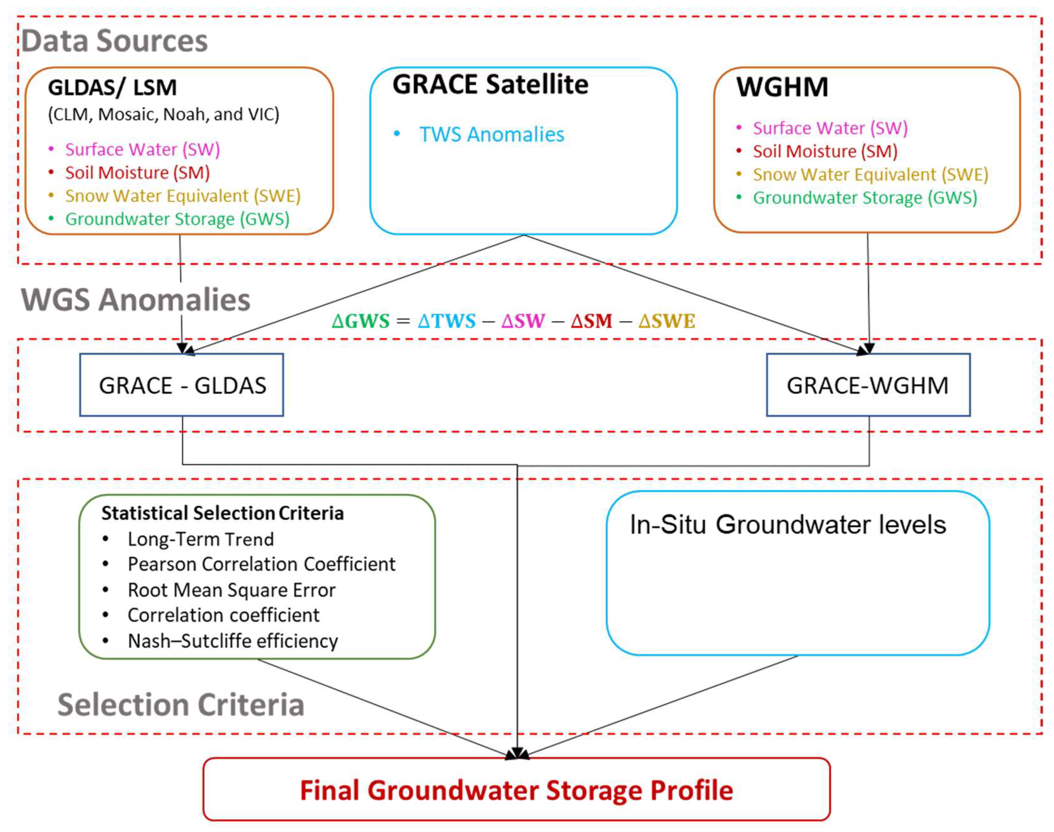
Figure 5. GRACE–GLDAS and GRACE–WGHM processing to get GWS from TWS.
References
- Rohith, G.; Sutha Kumar, L.; Purnamasayangsukasih, R.P.; Adnan, M.I.A. A review of uses of satellite imagery in monitoring mangrove forests. IOP Conf. Ser. Earth Environ. Sci. 2016.
- WMO. The Global Satellite Observing System: A Success Story|World Meteorological Organization. 2010. Available online: https://public.wmo.int/en/bulletin/global-satellite-observing-system-success-story (accessed on 8 January 2022).
- Elbeih, S.F. An overview of integrated remote sensing and GIS for groundwater mapping in Egypt. Ain Shams Eng. J. 2015, 6, 1–15.
- Nayak, T.R.; Gupta, S.K.; Galkate, R. GIS Based Mapping of Groundwater Fluctuations in Bina Basin. Aquat. Procedia 2015, 4, 1469–1476.
- Nouri, H.; Nagler, P.; Chavoshi Borujeni, S.; Barreto Munez, A.; Alaghmand, S.; Noori, B.; Galindo, A.; Didan, K. Effect of spatial resolution of satellite images on estimating the greenness and evapotranspiration of urban green spaces. Hydrol. Process. 2020, 34, 3183–3199.
- Huete, A.; Didan, K.; Miura, T.; Rodriguez, E.P.; Gao, X.; Ferreira, L.G. Overview of the radiometric and biophysical performance of the MODIS vegetation indices. Remote Sens. Environ. 2002, 83, 195–213.
- NASA-MODIS. 2020. Available online: https://earthdata.nasa.gov/earth-observation-data/near-real-time/download-nrt-data/modis-nrt (accessed on 25 September 2021).
- Jiao, J.J.; Zhang, X.; Wang, X. Satellite-based estimates of groundwater depletion in the Badain Jaran Desert, China. Sci. Rep. 2015, 5, 8960.
- Masood, A.; Mushtaq, H. Spatio-Temporal Analysis of Early Twenty-First Century Areal Changes in the Kabul River Basin Cryosphere. Earth Syst. Environ. 2018, 2, 563–571.
- Hashmi, M.Z.U.R.; Masood, A.; Mushtaq, H.; Bukhari, S.A.A.; Ahmad, B.; Tahir, A.A. Exploring climate change impacts during first half of the 21st century on flow regime of the transboundary kabul river in the hindukush region. J. Water Clim. Chang. 2020, 11, 1521–1538.
- Zhang, Z.; Moore, J.C. Mathematical and Physical Fundamentals of Climate Change. Available online: https://www.elsevier.com/books/mathematical-and-physical-fundamentals-of-climate-change/zhang/978-0-12-800066-3 (accessed on 25 September 2021). eBook ISBN: 97801280058352014.
- Cao, Z. Assessment methods for air pollution exposure. In Spatiotemporal Analysis of Air Pollution and Its Application in Public Health; Elsevier: Amsterdam, The Netherlands, 2020; pp. 197–206.
- Westerhoff, R.; White, P.; Rawlinson, Z. Application of global models and satellite data for smaller-scale groundwater recharge studies. Hydrol. Earth Syst. Sci. 2016.
- Elmahdy, S.; Mohamed, M.; Ali, T. Land use/land cover changes impact on groundwater level and quality in the northern part of the United Arab Emirates. Remote Sens. 2020, 12, 1715.
- USGS. What Is the Landsat Satellite Program and Why Is It Important?|U.S. Geological Survey. Available online: https://www.usgs.gov/faqs/what-landsat-satellite-program-and-why-it-important (accessed on 6 January 2022).
- Meyers, Z.P.; Frisbee, M.D.; Rademacher, L.K.; Stewart-Maddox, N.S. Old groundwater buffers the effects of a major drought in groundwater-dependent ecosystems of the eastern Sierra Nevada (CA). Environ. Res. Lett. 2021, 16, 044044.
- Sharma, A.K.; Hubert-Moy, L.; Buvaneshwari, S.; Sekhar, M.; Ruiz, L.; Bandyopadhyay, S.; Corgne, S. Irrigation history estimation using multitemporal landsat satellite images: Application to an intensive groundwater irrigated agricultural watershed in India. Remote Sens. 2018, 10, 893.
- Huntington, J.; McGwire, K.; Morton, C.; Snyder, K.; Peterson, S.; Erickson, T.; Niswonger, R.; Carroll, R.; Smith, G.; Allen, R. Assessing the role of climate and resource management on groundwater dependent ecosystem changes in arid environments with the Landsat archive. Remote Sens. Environ. 2016, 185, 186–197.
- Singh, R.K.; Khand, K.; Kagone, S.; Schauer, M.; Senay, G.B.; Wu, Z. A novel approach for next generation water-use mapping using Landsat and Sentinel-2 satellite data. Hydrol. Sci. J. 2020, 65, 2508–2519.
- Battude, M.; Al Bitar, A.; Morin, D.; Cros, J.; Huc, M.; Marais Sicre, C.; Le Dantec, V.; Demarez, V. Estimating maize biomass and yield over large areas using high spatial and temporal resolution Sentinel-2 like remote sensing data. Remote Sens. Environ. 2016, 184, 668–681.
- Clark, M.L. Comparison of simulated hyperspectral HyspIRI and multispectral Landsat 8 and Sentinel-2 imagery for multi-seasonal, regional land-cover mapping. Remote Sens. Environ. 2017, 200, 311–325.
- Ferrant, S.; Selles, A.; Le Page, M.; Herrault, P.A.; Pelletier, C.; Al-Bitar, A.; Mermoz, S.; Gascoin, S.; Bouvet, A.; Saqalli, M.; et al. Detection of irrigated crops from Sentinel-1 and Sentinel-2 data to estimate seasonal groundwater use in South India. Remote Sens. 2017, 9, 1119.
- Sadeghi, M.; Babaeian, E.; Tuller, M.; Jones, S.B. The optical trapezoid model: A novel approach to remote sensing of soil moisture applied to Sentinel-2 and Landsat-8 observations. Remote Sens. Environ. 2017, 198, 52–68.
- Campos-Taberner, M.; García-Haro, F.J.; Busetto, L.; Ranghetti, L.; Martínez, B.; Gilabert, M.A.; Camps-Valls, G.; Camacho, F.; Boschetti, M. A critical comparison of remote sensing Leaf Area Index estimates over rice-cultivated areas: From Sentinel-2 and Landsat-7/8 to MODIS, GEOV1 and EUMETSAT polar system. Remote Sens. 2018, 10, 763.
- Rozenstein, O.; Haymann, N.; Kaplan, G.; Tanny, J. Estimating cotton water consumption using a time series of Sentinel-2 imagery. Agric. Water Manag. 2018, 207, 44–52.
- Wang, Q.; Atkinson, P.M. Spatio-temporal fusion for daily Sentinel-2 images. Remote Sens. Environ. 2018, 204, 31–42.
- Eo Portal Directory. Copernicus: Sentinel-2—Satellite Missions—eoPortal Directory. Available online: https://earth.esa.int/web/eoportal/satellite-missions/c-missions/copernicus-sentinel-2 (accessed on 7 January 2022).
- Dubois, C.; Stoffner, F.; Kalia, A.C.; Sandner, M.; Labiadh, M.; Mimouni, M. Copernicus sentinel-2 data for the determination of groundwater withdrawal in the maghreb region. In Proceedings of the ISPRS Annals of the Photogrammetry, Remote Sensing and Spatial Information Sciences IV-1, Karlsruhe, Germany, 10–12 October 2018; Volume 4, pp. 37–44.
- Stoffner, F.; Mimouni, M. Application of sentinel 2 satellite imagery for sustainable groundwater management in agricultural areas—chtouka aquifer, morocco. Quaternary 2021, 4, 35.
- Galloway, D.L.; Jones, D.R.; Ingebritsen, S.E. Measuring Land Subsidence from Space; U.S. Geological Survey Fact Sheet 051–00; 2000; p. 4. Available online: http://pubs.usgs.gov/fs/fs-051-00/ (accessed on 30 November 2021).
- Lu, Y.Y.; Ke, C.Q.; Jiang, H.J.; Chen, D.L. Monitoring urban land surface deformation (2004–2010) from InSAR, groundwater and levelling data: A case study of Changzhou city, China. J. Earth Syst. Sci. 2019, 128, 159.
- Castellazzi, P.; Schmid, W. Interpreting C-band InSAR ground deformation data for large-scale groundwater management in Australia. J. Hydrol. Reg. Stud. 2021, 34, 100774.
- Srivastava, P.K.; Bhattacharya, A.K. Groundwater assessment through an integrated approach using remote sensing, GIS and resistivity techniques: A case study from a hard rock terrain. Int. J. Remote Sens. 2006, 27, 4599–4620.
- Famiglietti, J.S.; Rodell, M. Water in the balance. Science 2013, 340, 1300–1301.
- Hossain, A.A. Groundwater Depletion in the Mississippi Delta as Observed by the Gravity Recovery and Climate Experiment (GRACE) Satellite System. In Proceedings of the Mississippi Water Resources Conference, Jackson, MS, USA, 24–25 April 2014; pp. 59–65. Available online: https://www.wrri.msstate.edu/pdf/2014_wrri_proceedings.pdf (accessed on 1 October 2021).
- Landerer, F.W.; Swenson, S.C. Accuracy of scaled GRACE terrestrial water storage estimates. Water Resour. Res. 2012, 48, 1–11.
- Strugarek, D.; Sosnica, K.; Arnold, D.; J’ggi, A.; Zajdel, R.; Bury, G.; Drozdzewski, M. Determination of global geodetic parameters using satellite laser ranging measurements to sentinel-3 satellites. Remote Sens. 2019, 11, 2282.
- Long, D.; Pan, Y.; Zhou, J.; Chen, Y.; Hou, X.; Hong, Y.; Scanlon, B.R.; Longuevergne, L. Global analysis of spatiotemporal variability in merged total water storage changes using multiple GRACE products and global hydrological models. Remote Sens. Environ. 2017, 192, 198–216.
- Voss, K.A.; Famiglietti, J.S.; Lo, M.; de Linage, C.; Rodell, M.; Swenson, S.C. Groundwater depletion in the Middle East from GRACE with implications for transboundary water management in the Tigris-Euphrates-Western Iran region. Water Resour. Res. 2013, 49, 904–914.
- Alley, W.M.; Konikow, L.F. Bringing GRACE Down to Earth. Groundwater 2015, 53, 826–829.
- Lo, M.H.; Famiglietti, J.S.; Yeh, P.J.F.; Syed, T.H. Improving parameter estimation and water table depth simulation in a land surface model using GRACE water storage and estimated base flow data. Water Resour. Res. 2010, 46, 1–15.
- Rodell, M.; Velicogna, I.; Famiglietti, J.S. Satellite-based estimates of groundwater depletion in India. Nature 2009, 460, 999–1002.
- Bhanja, S.N.; Mukherjee, A.; Rodell, M. Groundwater Storage Variations in India; Springer: Singapore, 2018; pp. 49–59.
- Ahmed, K.; Shahid, S.; Demirel, M.C.; Nawaz, N.; Khan, N. The changing characteristics of groundwater sustainability in Pakistan from 2002 to 2016. Hydrogeol. J. 2019, 27, 2485–2496.
- Yin, W.; Hu, L.; Jiao, J.J. Evaluation of Groundwater Storage Variations in Northern China Using GRACE Data. Geofluids 2017, 2017, 8254824.
- Feng, W.; Zhong, M.; Lemoine, J.M.; Biancale, R.; Hsu, H.T.; Xia, J. Evaluation of groundwater depletion in North China using the Gravity Recovery and Climate Experiment (GRACE) data and ground-based measurements. Water Resour. Res. 2013, 49, 2110–2118.
- Castellazzi, P.; Martel, R.; Rivera, A.; Huang, J.; Pavlic, G.; Calderhead, A.I.; Chaussard, E.; Garfias, J.; Salas, J. Groundwater depletion in Central Mexico: Use of GRACE and InSAR to support water resources management. Water Resour. Res. 2016, 52, 5985–6003.
- Rodell, M.; Chen, J.; Kato, H.; Famiglietti, J.S.; Nigro, J.; Wilson, C.R. Estimating groundwater storage changes in the Mississippi River basin (USA) using GRACE. Hydrogeol. J. 2007, 15, 159–166.
- Shamsudduha, M.; Taylor, R.G.; Longuevergne, L. Monitoring groundwater storage changes in the highly seasonal humid tropics: Validation of GRACE measurements in the Bengal Basin. Water Resour. Res. 2012, 48, 1–12.
- Iqbal, N.; Hossain, F.; Lee, H.; Akhter, G. Satellite Gravimetric Estimation of Groundwater Storage Variations over Indus Basin in Pakistan. IEEE J. Sel. Top. Appl. Earth Obs. Remote Sens. 2016, 9, 3524–3534.
- Rodell, M.; Famiglietti, J.S. An analysis of terrestrial water storage variations in Illinois with implications for the Gravity Recovery and Climate Experiment (GRACE). Water Resour. Res. 2001, 37, 1327–1339.
- Strassberg, G.; Scanlon, B.R.; Chambers, D. Evaluation of groundwater storage monitoring with the GRACE satellite: Case study of the High Plains aquifer, central United States. Water Resour. Res. 2009, 45, 1–10.
- Huang, Z.; Pan, Y.; Gong, H.; Yeh, P.J.-F.; Li, X.; Zhou, D.; Zhao, W. Subregional-scale groundwater depletion detected by GRACE for both shallow and deep aquifers in North China Plain. Geophys. Res. Lett. 2015, 42, 1791–1799.
- Yeh, P.J.F.; Swenson, S.C.; Famiglietti, J.S.; Rodell, M. Remote sensing of groundwater storage changes in Illinois using the Gravity Recovery and Climate Experiment (GRACE). Water Resour. Res. 2006, 42, 1–7.
- Döll, P.; Hoffmann-Dobrev, H.; Portmann, F.T.; Siebert, S.; Eicker, A.; Rodell, M.; Strassberg, G.; Scanlon, B.R. Impact of water withdrawals from groundwater and surface water on continental water storage variations. J. Geodyn. 2012, 59–60, 143–156.
- Jiang, D.; Wang, J.; Huang, Y.; Zhou, K.; Ding, X.; Fu, J. The review of GRACE data applications in terrestrial hydrology monitoring. Adv. Meteorol. 2014, 2014, 725131.
- Mohanasundaram, S.; Mekonnen, M.M.; Haacker, E.; Ray, C.; Lim, S.; Shrestha, S. An application of GRACE mission datasets for streamflow and baseflow estimation in the Conterminous United States basins. J. Hydrol. 2021, 601, 126622.
- Tiwari, V.M.; Wahr, J.; Swenson, S. Dwindling groundwater resources in northern India, from satellite gravity observations. Geophys. Res. Lett. 2009, 36, L18401.
- Famiglietti, J.S.; Lo, M.; Ho, S.L.; Bethune, J.; Anderson, K.J.; Syed, T.H.; Swenson, S.C.; De Linage, C.R.; Rodell, M. Satellites measure recent rates of groundwater depletion in California’s Central Valley. Geophys. Res. Lett. 2011, Vol. 38, 1–4.
- Castle, S.L.; Thomas, B.F.; Reager, J.T.; Rodell, M.; Swenson, S.C.; Famiglietti, J.S. Groundwater depletion during drought threatens future water security of the Colorado River Basin. Geophys. Res. Lett. 2014, 41, 5904–5911.
- Alley, W.M.; Clark, B.R.; Ely, D.M.; Faunt, C.C. Groundwater Development Stress: Global-Scale Indices Compared to Regional Modeling. Groundwater 2018, 56, 266–275.
- Sun, A.Y.; Green, R.; Rodell, M.; Swenson, S. Inferring aquifer storage parameters using satellite and in situ measurements: Estimation under uncertainty. Geophys. Res. Lett. 2010, 37, 1–5.
- Frappart, F.; Ramillien, G. Monitoring groundwater storage changes using the Gravity Recovery and Climate Experiment (GRACE) satellite mission: A review. Remote Sens. 2018, 10, 829.
- Rzepecka, Z.; Birylo, M. Groundwater storage changes derived from GRACE and GLDAS on smaller river basins—A case study in Poland. Geosciences 2020, 10, 124.
- ASCE. Artificial Neural Networks in Hydrology. I: Preliminary Concepts. J. Hydrol. Eng. 2000, 5, 115–123.
- ASCE. Artificial Neural Networks in Hydrology. II: Hydrologic Applications. J. Hydrol. Eng. 2000, 5, 124–137.
- Chang, F.J.; Chang, Y.T. Adaptive neuro-fuzzy inference system for prediction of water level in reservoir. Adv. Water Resour. 2006, 29, 1–10.
- House-Peters, L.A.; Chang, H. Urban water demand modeling: Review of concepts, methods, and organizing principles. Water Resour. Res. 2011, 47, 1–15.
- Hsu, K.; Gupta, H.V.; Sorooshian, S. Artificial neural network modeling of the rainfall-runoff process. Water Resour. Res. 1995, 10, 2517–2530.
- Maier, H.R.; Jain, A.; Dandy, G.C.; Sudheer, K.P. Methods used for the development of neural networks for the prediction of water resource variables in river systems: Current status and future directions. Environ. Model. Softw. 2010, 25, 891–909.
- Moradkhani, H.; Hsu, K.L.; Gupta, H.V.; Sorooshian, S. Improved streamflow forecasting using self-organizing radial basis function artificial neural networks. J. Hydrol. 2004, 295, 246–262.
- Haykin, S. Neural Networks and Learning Machines; Pearson: Hamilton, ON, Canada, 2008; Volume 3, p. 937. Available online: https://cours.etsmtl.ca/sys843/REFS/Books/ebook_Haykin09 (accessed on 6 January 2022).
- Sun, A.Y. Predicting groundwater level changes using GRACE data. Water Resour. Res. 2013, 49, 5900–5912.
- Seo, J.Y.; Lee, S. Il Spatio-temporal ground water drought monitoring using multi-satellite data based on an artificial neural network. Water 2019, 11, 1953.
- Gemitzi, A.; Tsagkarakis, K.; Lakshmi, V. Determination of Groundwater Abstractions by Means of GRACE Data and Artificial Neural Networks; Geophysical Research Abstracts Vol. 19, EGU2017-3649; EGU General Assembly: Vienna, Austria, 2017; Available online: https://meetingorganizer.copernicus.org/EGU2017/EGU2017-3649.pdf (accessed on 15 October 2021).
- Mallick, J.; Singh, C.K.; Al-Wadi, H.; Ahmed, M.; Rahman, A.; Shashtri, S.; Mukherjee, S. Geospatial and geostatistical approach for groundwater potential zone delineation. Hydrol. Process. 2015, 29, 395–418.
- Pinto, D.; Shrestha, S.; Babel, M.S.; Ninsawat, S. Delineation of groundwater potential zones in the Comoro watershed, Timor Leste using GIS, remote sensing and analytic hierarchy process (AHP) technique. Appl. Water Sci. 2017, 7, 503–519.
- Xiao, R.; He, X.; Zhang, Y.; Ferreira, V.G.; Chang, L. Monitoring groundwater variations from satellite gravimetry and hydrological models: A comparison with in-situ measurements in the mid-atlantic region of the United States. Remote Sens. 2015, 7, 686–703.
- Abou Zaki, N.; Torabi Haghighi, A.; Rossi, P.M.; Tourian, M.J.; Kløve, B. Monitoring Groundwater Storage Depletion Using Gravity Recovery and Climate Experiment (GRACE) Data in Bakhtegan Catchment, Iran. Water 2019, 11, 1456.
- Döll, P.; Kaspar, F.; Lehner, B. A global hydrological model for deriving water availability indicators: Model tuning and validation. J. Hydrol. 2003, 270, 105–134.
- Döll, P.; Müller Schmied, H.; Schuh, C.; Portmann, F.T.; Eicker, A. Global-scale assessment of groundwater depletion and related groundwater abstractions: Combining hydrological modeling with information from well observations and GRACE satellites. Water Resour. Res. 2014, 50, 5698–5720.
More
Information
Subjects:
Water Resources
Contributors
MDPI registered users' name will be linked to their SciProfiles pages. To register with us, please refer to https://encyclopedia.pub/register
:
View Times:
5.9K
Revisions:
5 times
(View History)
Update Date:
18 Feb 2022
Table of Contents


Notice
You are not a member of the advisory board for this topic. If you want to update advisory board member profile, please contact office@encyclopedia.pub.
OK
Confirm
Only members of the Encyclopedia advisory board for this topic are allowed to note entries. Would you like to become an advisory board member of the Encyclopedia?
Yes
No
${ textCharacter }/${ maxCharacter }
Submit
Cancel
Back
Comments
${ item }
|
${ item.createdUser.fullName }
${ item.createdAt }
${ item.vote }
${ item.reply }
Delete
${ reply.createdUser.fullName }
${ reply.createdAt }
${ reply.vote }
Delete
There is no reply to this comment~
${ item.replyTextCharacter }/${ item.replyMaxCharacter }
Submit
Cancel
More
No more~
There is no comment~
${ textCharacter }/${ maxCharacter }
Submit
Cancel
${ selectedItem.replyTextCharacter }/${ selectedItem.replyMaxCharacter }
Submit
Cancel
Confirm
Are you sure to Delete?
Yes
No