Your browser does not fully support modern features. Please upgrade for a smoother experience.
Submitted Successfully!
 +1 credit
Thank you for your contribution! You can also upload a video entry or images related to this topic.
For video creation, please contact our Academic Video Service.
| Version | Summary | Created by | Modification | Content Size | Created at | Operation |
|---|---|---|---|---|---|---|
| 1 | Rizkiana Sidqiyatul Hamdani | + 3404 word(s) | 3404 | 2021-12-28 04:26:42 | | | |
| 2 | Jessie Wu | Meta information modification | 3404 | 2022-01-11 15:44:42 | | | | |
| 3 | Jessie Wu | -13 word(s) | 3391 | 2022-01-11 15:47:35 | | | | |
| 4 | Jessie Wu | -40 word(s) | 3364 | 2022-01-11 15:51:14 | | |
Video Upload Options
We provide professional Academic Video Service to translate complex research into visually appealing presentations. Would you like to try it?
Cite
If you have any further questions, please contact Encyclopedia Editorial Office.
Hamdani, R. Monitoring and Addressing Land Subsidence Hazards in Semarang. Encyclopedia. Available online: https://encyclopedia.pub/entry/18055 (accessed on 24 July 2026).
Hamdani R. Monitoring and Addressing Land Subsidence Hazards in Semarang. Encyclopedia. Available at: https://encyclopedia.pub/entry/18055. Accessed July 24, 2026.
Hamdani, Rizkiana. "Monitoring and Addressing Land Subsidence Hazards in Semarang" Encyclopedia, https://encyclopedia.pub/entry/18055 (accessed July 24, 2026).
Hamdani, R. (2022, January 11). Monitoring and Addressing Land Subsidence Hazards in Semarang. In Encyclopedia. https://encyclopedia.pub/entry/18055
Hamdani, Rizkiana. "Monitoring and Addressing Land Subsidence Hazards in Semarang." Encyclopedia. Web. 11 January, 2022.
Copy Citation
Land subsidence is a major cause of environmental degradation. It increases the exposure of global sea level rise-related disasters in coastal cities lying on young sediment. This article reviews the advancement of measures in dealing with this hazard taken by researchers, the government, and the people.
Semarang
land subsidence
coastal
spatial planning
1. Background
Semarang City, a coastal city in Central Java Province, Indonesia, is one of the national strategic activity centers that connects the eastern and western part of the island. This 373-kilometre square city is home to about 1.8 million people. Well known as “the city where its rivers are flooding”, the government had acted with regard to flooding-related issues, as they pioneered participation in the 100 Resilient Cities program[1], joined the Asian Cities Climate Change Resilience Network (ACCRN) in 2009[2], and took part in the Water As Leverage pilot project[3]. But this city is still under the threat of being sunk[4][5]. Water needs that have increased by more than 960% since 1910 are not fully met by the local water provider[3]. Consequently, the land subsidence rate is still severe, reaching about 24–36 cm/year through 2014–2017[6]. An estimation by Sarah [7] stated that land subsidence in this city has caused 3.5 trillion rupiah (±245 billion USD) in economical loss. However, this hazard is not well incorporated into their planning and development policies[8].
Land subsidence in coastal cities is a complex environmental problem. It is related to urban development and land utilization that does not comply with the ecological threshold. Economic activity undertaken by industry is exploiting the groundwater, social justice where the local residents having limited access to water, the building loads that is hard to control so then exceeding its bearing capacity, as well as the geological phenomenon where the subsiding land of this city is actually lying on a young sediments that is still in the process of natural compaction [9][10][11][12][13][14]. To achieve comprehension of the complexities and dynamics of the socio-ecological system and further address the risk of land subsidence, there is a need for an inter-disciplinary approach[11][15] and integrated analysis[4][16][17][18] and management [19][20][21][22][23], in addition to the involvement of multiple-stakeholders [22]. However, comprehensive discussions on land subsidence in Semarang city are still limited. Abidin et al. [24] comprehensively assessed the characteristics, impact, and causes of land subsidence in Semarang. Nevertheless, they did not address criticisms of governmental measures or the current adaptive measures undertaken by the community. Another comprehensive study was undertaken by Saputra et al. [11][25][26] who discussed the government’s awareness and people’s adaptation. Quite similar to this research, Bott et al. [27] also assessed the risk perception and adaptation measures taken by the locals, but they first explored the physical processes. However, those studies only partially discuss the multi-year progress and possible improvements with regard to how this city deals with land subsidence.
2. Data Description and Initial Insight
The three most dominant sources of the reviewed literature were Conference Proceedings (37%), International Journals (31%), and National Journals (26%). According to the year-based tabulation, as shown in Figure 1, there was an increment in land subsidence research in the last two decades. Although there was a decline from 2019 to 2020, the number of published research followed a linear trendline. Another significant decrease happened between 2020–2021, presumably related to the execution period of this study. Such increment is a positive sign of progress in understanding land subsidence.
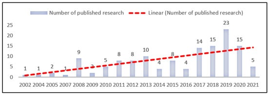
Figure 1. The increasing number of land subsidence research.
Another initial insight was gained from a word cloud generated using Atlas.ti. As shown in Figure 2 below, “water” and “groundwater” are among the most discussed terminologies in the reviewed papers, as their font size is larger than the other. This shows that the water management perspective is deeply included in land subsidence discussions. The word cloud also provides a preliminary understanding on the broadness of topics reviewed in this paper. Although used “monitoring” as part of the search query, it does not necessarily mean that the papers generated from the search are limited to monitoring measures. This explains why the font size for the term “monitoring” (Figure 2; lower left) is relatively small and comparable to that for “management” and “adaptation”.
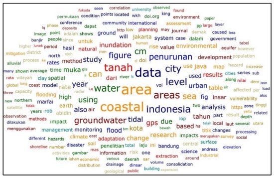
Figure 2. Word cloud generated from literatures reviewed in this paper using Atlas.ti 9.1. Only words with a minimum of 131 mentions were included, while “Semarang” and “Land Subsidence” were excluded from the analysis. Font size indicates frequency of terminology use, in which larger font size shows that the word is mentioned more often in the reviewed papers.
3. Advancement in Land Subsidence Rate Monitoring Measures
Land subsidence rate monitoring is assessing land elevation differences between a specific time range. This process could be used to provide a comprehensive understanding of the spatial pattern, rates, and displacement of land subsidence [1][28][29] by assessing elevation changes over time [2][30] and to estimate future conditions [3][31]. This is also the initial step in mitigating the risk of land subsidence [1][32][33][34]. Effective monitoring measures is necessary to help developers or individuals to take the best action in adapting to subsidence [9]. Better management of land utilization and water supply could also be achieved [2][3][9][33][35][36].
The most severe land subsidence rates were reported in the northeastern part of the coastal area in Semarang [37][38][39][40][41][42][43][44][45][46]. According to the spatial estimation, land subsidence occurs in 32.92% of the city area, which is about 128.65 km2 [47]. The western part of the city has a relatively lower risk for land subsidence [37][39][48]. Land use activities that are related to the highest subsidence rates are: (1) port and sea transportation activities at Tanjung Emas Harbour (Pelabuhan Tanjung Emas) [32][42][49][50]; (2) industrial areas [1][51][52][53] (Genuk District [4][5][51][54], North Semarang District [4][50]); (3) housing areas [32][51][55]; and (4) an old city post-Dutch quarter tourism area [2].
As shown in Appendix A, the maximum annual subsidence rates observed in the coastal area of Semarang are up to 15–19 cm/year. The rates in 2008–2010 were relatively steady, while an increase was observed in 2010 and so forth [41][44]. On the other hand, benchmark data assessed by Suprabadevi et al. [46] showed that the highest accumulative subsidence rate was observed at 33.5 cm in 2008–2011.
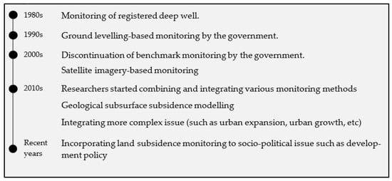
As shown in Figure 3, in the 1980s, monitoring was done based on geodetic measurement using the ground-levelling technique by installing grounded concrete piles or conducting a ground survey using Global Positioning System (GPS) tools. However, as this method relies on the subsiding ground, its stability and continuity are questionable. Hence, in the 2000s, satellite imagery that can encompass a wider area and better data availability was used for long-term monitoring. Critical reviews also stated that this method had flaws, such as overestimation and the “no-subsidence” bias caused by low coherence data.
Monitoring is done in various models that might lead to different results corresponding with different perceived impacts [42][51]. This has the potential to mislead the mitigation and adaptation projects [59]. As there is limited research showing accumulative subsidence rates, this may also lead to a bias for the actual subsidence events. The Interferometric Synthetic Aperture Radar (InSAR) is a common method used to analyze the rates of subsidence [44] by comparing digital elevation models between two satellite images [61]. Another method, microgravity, effectively measures subsidence based on geological elevation [62]. The Global Positioning System (GPS) is also a remarkable method [44]. Some researchers argue that InSAR is better than the other because it could monitor surface deformation in a large area without risking any device on the subsiding yet unstable soil [38]. Others prefer to utilize InSAR as a complementary technique to confirm each other’s results and to test for data reliability [30][41][52][60][63], to confront [64], or merely to highlight any differences [28]. Effective monitoring measures could then be defined as (i) using a combined method, which primarily relies on satellite data (using InSAR) which then supported by field survey and observation (using GPS) and (ii) the ability to provide information not merely about yearly rates but also about the accumulative subsidence.
Primarily, monitoring measures is dominated by the backcasting technique. The timeline of land subsidence research as shown in Appendix B are all a backcasting estimation (from the recent years and backwards), except from Marfai [3] that also used the forecasting measurement (from recent years and forward). Monitoring measures also dominated by the assessment of the average annual rates rather than the accumulative rates. As shown in Appendix A, the maximum annual subsidence rates observed in the coastal area of Semarang are up to 15–19 cm/year. The rates in 2008–2010 were relatively steady, while an increase was observed in 2010 and so forth [41][44]. On the other hand, benchmark data assessed by Suprabadevi at al. [46] showed that the highest accumulative subsidence rate was observed at 33.5 cm in 2008–2011. The annual rates were almost consistent in the previous decades; this may cause the misunderstanding that land subsidence is a normal condition in Semarang and the subsidence rates in this city will always remain the same. As there is limited research showing accumulative subsidence rates, this may lead to a bias for the actual subsidence events. In addition, accumulative subsidence rates are essential to indicate the urgency of taking further measures in subsiding areas.
4. Debates on Anthropogenic Subsidence Narratives
Understanding the cause and impact of subsidence is essential in choosing the best adaptation and mitigation measures. Various perspectives regarding this matter may lead to comprehensive understanding, yet at the same time confuse what the priorities are. Researchers, in general, agree that land subsidence is a type of ground surface deformation [38] caused by the consolidation process that lowered the upper soil layer. However, there are ongoing debates on whether the cause is the natural consolidation of young sediment or anthropogenic stressors.
Geological researchers prefer to consider land subsidence as a natural process. Geomorphological processes, mainly sedimentation, have led to land compaction in the coastal areas of Semarang in recent geological years. The coastal area relies on young alluvium sediments that still undergo the process of natural consolidation [64][24][28][32][45][61][65][66][67]. Fakhri Islam [63] and Yastika et al. [30] indicated that the land subsidence spatial pattern is similar to the young alluvial soil spatial pattern. Such areas consist of a thick, soft layer of clay, gravel, and silt [24][32][33]. Masvika [68] did a borehole analysis and then agreed with this proposition.
There are some theoretical understandings and empirical analyses that suggest that land subsidence in Semarang’s urbanized coastal area is anthropogenic. In his book, Pipkin [8] categorized natural subsidence as that with a rate of below 4 cm/year. Another argument from Kuehn et al. [2] stated that natural subsidence “rarely exceeds 1 cm/year”. Geological research for a land subsidence estimation by Sophian [69] showed that although subsidence does occur in areas where natural consolidation is ongoing, this phenomenon could become more severe due to the increasing construction and infrastructure loads in the future. The author reported that land overburdening contributes to half of the subsidence events. Recently, Sarah et al. [70] addressed the debate through natural compaction analysis. They stated that land compaction in Semarang is mainly caused by groundwater exploitation, which results in an over-pressured soil layer. They found that the rate of natural subsidence is relatively low (0.3 cm/year) compared to that of the anthropogenic subsidence (17 cm/year). Therefore, they concluded that natural compaction in the case of Semarang is “hardly present”.
Empirical research articles further disclosed that land subsidence in Semarang is mainly caused by the overexploitation of groundwater by the urban activity, industries and domestic users. Hadi [71] found that people in the subsiding areas are consuming water from their neighbour’s deep wells. Some researchers believed that subsidence has occurred since the 1980s, when the population started to grow rapidly [30][28], groundwater extraction has increased exponentially since then [72]. Some other researchers argue that land subsidence in Semarang has happened since the early 20th century [29][33][42][72]. The superimposed analysis, where two or more spatial data are is overlapped and analysed using certain spatial analyst software such as ArcGIS, confirms that land subsidence is limited to areas where the aquifer system is overused [52]. Research dedicated to assessing the correlation between the decrease in groundwater levels and land subsidence has proven that both variables are highly correlated [2][28][36][73][74][75][76][77]. In areas experiencing severe subsidence, such as Kaligawe and Genuksari, they also possess a deficit in groundwater [18]. Groundwater extraction has increased because local piped water provision companies cannot fulfil the entire city’s domestic and industrial water demand [6][14][56][19][78][79][80][81]. On the other side, young alluvium sediments where those activities occur have high groundwater potential [82][83]. Land subsidence also induces seawater intrusion, which leads to hydraulic conductivity increments and subsequently increases the subsidence or consolidation rates [84].
Land subsidence is also correlated with urban growth expansion [4][57][34][50][85][86]. Land-use change due to industrial area development has occurred in the coastal areas [71]. For example, a total of 698 ha of land in coastal cities has been shifted from agricultural to built-up areas between 1998 and 2008 [87]. Consequently, this caused water recharge disturbance, an increase in groundwater use, and soil overburdening due to increased building loads [1][3][77]. Urbanization in the form of coastal land reclamation also caused land subsidence [88]. Land reclamation projects led to land progression towards the sea [89]. Marshland in coastal areas was buried in developing housing and infrastructures. Combined spatial and temporal analysis showed that the urban development in Semarang was heading towards the coasts in 1998–2018 [90]. Abidin et al. [24] explained that the sedimentation process in Semarang’s shoreline is significantly progressing towards the sea, with an average rate up to 8 m/year from 1965 to the early 1990s. A long-term shoreline analysis from 1903–2003 by Marfai [91] also demonstrated that the 100-year-old coastal seaward progression was not only a result of natural sedimentation but also infrastructure development. Furthermore, reclamation also has a negative impact, as it may change wave patterns, potentially leading to erosion in surrounding areas [20].
Although agreeing with the views of other researchers, Kasfari [36] believes that urban growth determined by population growth will not affect the severity of land subsidence. They came to this conclusion based on their assessment of population and the rates, and they found that the most populated areas are experiencing the slowest subsidence. At the same time, the most sparsely populated international airport is experiencing the fastest subsidence. The subsidence in the new airport development zone is presumably due to required man-made and technologically induced subsidence to stabilize the land, so there will be no subsidence in the future [92]. Therefore, the prior argument might be less relevant to deny the fact that urban development, the anthropogenic stressors, is causing land subsidence.
Based on these insights, land subsidence in the case of Semarang is mainly anthropogenically induced. As also shown in the code-network in Figure 4, the natural process has limited contribution to land subsidence in Semarang. The technical practice of this understanding is well presented by Dong et al. [93], who utilizes the geotechnical approach as a control for land use development.
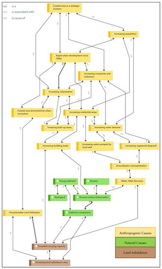
Figure 4. Code-network for the identification of land subsidence causes in Semarang.
5. People and Public Official Awareness on Land Subsidence Impact and Their Responses
Land subsidence in low-lying coastal areas created an enormous impact on the city. As discussed in the literature (see Table 1), subsidence has brought the land elevation below sea level. Local land subsidence is the most influential factor that worsens tidal flooding [94]. It also induced erosion, leading to the removal of 1764.5 ha of land in Semarang coastal areas [95]. Suripin and Helmi [95] assessed that the rate of shoreline retreat in 1991–2009 reached 178 m/year. Andreas et al. [44] used high-resolution satellite imagery analysis to show that the areas surrounding Tanjung Mas and the north-eastern coast of Semarang had been submerged. Marfai [96] predicted that the coastal areas of Semarang city will be submerged further. Land subsidence might cause Semarang to lose its coastal areas in the future [7][70][95].
Table 1. Land subsidence impact.
| Impact | References |
|---|---|
| Degrading Environmental condition | |
| Worsening tidal flooding exposure | [4][9][10][56][82][37][22][24][29][31][44][51][69][94][97][98][99][100] |
| Submerged/loss of land | [4][28][34][44][46][68][95][101] |
| Changing shoreline | [91][102] |
| Seawater intrusion | [33][52][87][94][103][104][105] |
| Physical Infrastructure Destruction | |
| Sinking and abandoned house/building | [10][27][60][106] |
| Damaging building, road, drainage system | [2][9][30][96][60][74][106][107][108] |
| Economical Loss | |
| Increasing cost of maintenance (household and government) | [2][9][105] |
| Land value decrease | [109] |
| Property value decrease | [101] |
| Disruption in economic activities | [43][101] |
| Worsening Social Quality of life | |
| Lowering quality of life | [9][27][39][51][53][60][106] |
| Disrupting local people’s day-to-day activity | [25][24][46][101][110][111] |
| Increasing coastal vulnerability | [2][5] |
| Increasing harmful sanitation-related diseases such as Malaria, Dengue, Labtoferosis, etc. | [112][32][111][113] |
Towards the city center, it has caused damage to buildings and streets and degraded people’s quality of life. The economic loss caused by subsidence in Semarang is estimated at 3.5 trillion Rupiah or 247.9 million USD [7]. A land value assessment by Utami et al. [109] stated that areas impacted by tidal floods and land subsidence suffer from land price stagnation and decrease.
Both the people and the government overlook the matter of land subsidence. As shown in Figure 5, measures taken by both stakeholders are dominated by those that are aimed to tackle coastal flood impact [19][26][88]. This contrasts with the fact that the government already knew the importance of tackling land subsidence. They instead took limited measures in dealing with land subsidence. The government initiated subsidence monitoring three decades ago [3] yet discontinued the measure in 2000. In the same year, they also profiled the areas and the people under the risk of land subsidence [114][115]. The Semarang Government had also collaborated with GIZ in developing land subsidence monitoring data in 2013. Unfortunately, this project was also discontinued. The government has taken structural (building dykes, pumping stations, flood gates, polder systems, etc.) as well as non-structural measures (seed funding, developing compensation plan, community empowerment, etc.) to mitigate the impact of tidal flooding [96][111][116]. They even created specific task forces that focused on every coastal issue and worked on monitoring, law enforcement, and infrastructure improvement. Unfortunately, as reported previously [23][114][115][116], the task force working on land subsidence is focused only on monitoring. The spatial planning document does not incorporate land subsidence either [19]. This might be due to the fact that land subsidence is not considered as a disaster in the national disaster management law. According to Marfai’s [96] analysis on the comprehensive flood management system in Semarang, the government of the city did not provide housing or water alternatives. This finding resonates with what was previously reported by Abidin et al. [53].
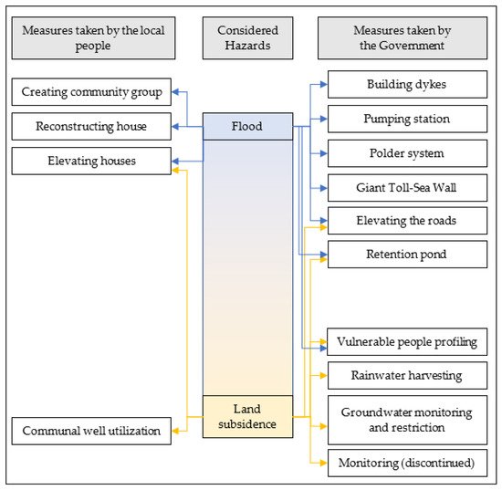
Figure 5. Graphical mapping of measures taken by the government and the people based on considered hazards.
People living in the coastal villages are aware that the tidal flood inundation they suffer from is caused by land subsidence [27][22][115][116][117]. They know the hazards and risks of such a situation, yet they end up adapting to it rather than moving to a safer location due to several reasons [116][118][119]. As mentioned above, affordable housing and water source alternatives are not available. Those who do not have the economic power to obtain housing at a safer location elsewhere have no option but to stay. For some, they refuse to relocate because their livelihood relies on the coastal ecosystem [110][118][119]. Even those with higher incomes are reluctant to move because they do not wish to lose their asset ownership in the subsiding areas [119].
Various strategies to adapt to tidal floods and land subsidence have been reported. Fauziah [120] found that the social and economic capital highly influence people’s adaptability. People in tidal flood-impacted areas established community groups (paguyuban) to strengthen their social capital [111]. Some people use communal wells to fulfill their freshwater needs [118]. They regularly reconstruct their house, such as making overhead furniture to protect their assets during the flood [110][121][122]. Their perceived ability to adapt, as a result of the belief that they could improve their environment, also pushes them to elevate the position of their house in respect to surrounding grounds [27][111][113]. This has been done at least every five years, as reported by Hadi [111]. People also used trash to build dikes and protect their housing from tidal floods [121].
Critically speaking, these measures are not optimal [123], and may give the false impression of harmony. They could only provide simple, short-term physical solutions that do not necessarily improve the environment [116]. Moreover, measures to elevate the housing grounds create more load to the soil and consequently accelerate the land subsidence rate. This problem is referred to by Saputra [25] as a vicious cycle that the people shall escape. The reason behind it is well-explained by Saharom [124], that people are keen to adapt to the situation, but they are not knowledgeable about ideal housing systems and the use of sustainable and durable materials. The people themselves are aware of such limitations [111].
On the other hand, some people showed a degree of acceptance. They no longer consider tidal floods or land subsidence as a hazard. They believe that tidal flooding is a natural phenomenon that comes from God, and land subsidence is also a natural occurrence that affects everyone in the coastal areas [27].
References
- Sarah, D.; Satriyo, N.A.; Mulyono, A. Kajian awal estimasi kerugian fisik akibat amblesan tanah di Kota Semarang (in Bahasa Indonesia). In Peran Penelitian Geoteknologi untuk Menunjang Pembangunan Berkelanjutan di Indonesia, Proceedings of the Prosiding Pemaparan Hasil Penelitian Pusat Penelitian Geoteknologi LIPI, Bandung, Indonesia, 2 November 2014; Hery, H., Robert, M.D., Edi, P.U., Harjanto, S., Haryadi, P., Herryal, Z.A., Eko, T.S., Eko, S., Heru, S., Eds.; Pusat Penelitian Geoteknologi Lembaga Ilmu Pengetahuan Indonesia (LIPI): Bandung, Indonesia, 2015; pp. 37–45.
- Hamdani, R.S.; Hadi, S.P.; Rudiarto, I.; Purnaweni, H. Do we care enough? revisiting land subsidence and coastal spatial planning policy in Semarang, Indonesia. In E3S Web of Conferences, Proceedings of The 5th International Conference on Energy, Environmental and Information System (ICENIS 2020), Semarang, Indonesia, 12–13 August 2020; EDP Sciences: Les Ulis, France, 2020; Volume 202, p. 06005.
- Dewi, R.S. Monitoring long-term shoreline changes along the coast of Semarang. In IOP Conference Series: Earth and Environmental Science, Proceedings of The 5th International Symposium on LAPAN-IPB Satellite for Food Security and Environmental Monitoring 2018 (LISAT-FSEM 2018), IPB International Convention Center, Bogor, Indonesia, 6–7 November 2018; IOP Publishing: Bristol, UK, 2019; Volume 284, p. 012035.
- Hadi, S.P.; Anggoro, S.; Purnaweni, H.; Yuliastuti, N.; Ekopriyono, A.; Hamdani, R.S. Assessing the giant sea wall for sustainable coastal development: Case study of Semarang City, Indonesia. AACL Bioflux. 2020, 13, 3674–3682.
- Maimunah, S.; Rosli, N.S.; Rafanoharana, S.; Sari, K.R.; Higashi, O. Strengthening Community to Prevent Flood using Participatory Approach: A case of Semarang City, Indonesia. J. Int. Dev. Coop 2011, 18, 19–28.
- Wijaya, N. Climate Change Adaptation Measures in the Coastal City of Semarang, Indonesia: Current Practices and Perfor-mance. J. Perenc. Wil. Dan Kota 2015, 26, 28–42.
- Abidin, H.; Andreas, H.; Gumilar, I.; Sidiq, T.; Fukuda, Y. Land subsidence in coastal city of Semarang (Indonesia): Characteristics, impacts and causes. Geomatics Nat. Hazards Risk 2013, 4, 226–240.
- Saputra, E. Land Subsidence as a Sleeping Disaster Case studies from Indonesia. Doctoral Dissertation, Utrecht University, Utrecht, The Netherlands, 2020.
- Saputra, E.; Spit, T.; Zoomers, A. Living in a Bottomless Pit: Households’ Responses to Land Subsidence, an Example from Indonesia. J. Environ. Prot. 2019, 10, 1–21.
- Saputra, E.; Hartmann, T.; Zoomers, A.; Spit, T. Fighting the ignorance: Public authorities’ and land users’ responses to land subsidence in Indonesia. Am. J. Clim. Chang. 2017, 4, 1–21.
- Bott, L.-M.; Schöne, T.; Illigner, J.; Haghighi, M.H.; Gisevius, K.; Braun, B. Land subsidence in Jakarta and Semarang Bay—The relationship between physical processes, risk perception, and household adaptation. Ocean Coast. Manag. 2021, 211, 105775.
- Lubis, A.M.; Sato, T.; Tomiyama, N.; Isezaki, N.; Yamanokuchi, T. Ground subsidence in Semarang-Indonesia investigated by ALOS–PALSAR satellite SAR interferometry. J. Asian Earth Sci. 2011, 40, 1079–1088.
- Yuwono, B.D.; Awaluddin, M. Land Subsidence monitoring 2016–2018 analysis using GNSS CORS UDIP and DinSAR in Semarang. In KnE Engineering, Proceedings of the 1st International Conference on Geodesy, Geomatics, and Land Administration, Semarang, Indonesia, 24–25 July 2019; KnE Publishing: Dubai, UAE, 2019; pp. 95–105.
- Abidin, H.Z.; Andreas, H.; Gumilar, I.; Sidiq, T.P.; Gamal, M.; Murdohardono, D. Studying Land Subsidence in Semarang (In-donesia) using Geodetic Methods. In Proceedings of the FIG Congress, Sydney, Australia, 11–16 April 2010.
- Kuehn, F.; Albiol, D.; Cooksley, G.; Duro, J.; Granda, J.; Haas, S.; Hoffmann-Rothe, A.; Murdohardono, D. Detection of land subsidence in Semarang, Indonesia, using stable points network (SPN) technique. Environ. Earth Sci. 2010, 60, 909–921.
- Yastika, P.E.; Shimizu, N.; Abidin, H. Monitoring of long-term land subsidence from 2003 to 2017 in coastal area of Semarang, Indonesia by SBAS DInSAR analyses using Envisat-ASAR, ALOS-PALSAR, and Sentinel-1A SAR data. Adv. Space Res. 2019, 63, 1719–1736.
- Marfai, M.A.; King, L. Monitoring land subsidence in Semarang, Indonesia. Environ. Earth Sci. 2007, 53, 651–659.
- Kahar, S.; Purwanto, W.K. Hidajat, Dampak penurunan tanah dan kenaikan muka laut terhadap luasan genangan rob di Semarang. J. Presipitasi 2010, 7, 83–91.
- Widada, S.; Zainuri, M.; Yulianto, G.; Satriadi, A.; Wijaya, Y.J. Estimation of Land Subsidence Using Sentinel Image Analysis and Its Relation to Subsurface Lithology Based on Resistivity Data in the Coastal Area of Semarang City, Indonesia. J. Ecol. Eng. 2020, 21, 47–56.
- Sarah, D.; Syahbana, A.J.; Lubis, R.F.; Mulyono, A. Modelling of Land Subsidence Along Tanah Mas—Pelabuhan Section Semarang City Using Finite Element Method. Ris. Geol. Dan Pertamb. 2011, 21, 105.
- Koch, M.; Gaber, A.; Darwish, N.; Bateman, J.; Gopal, S.; Helmi, M. Estimating Land Subsidence in Relation to Urban Expansion in Semarang City, Indonesia, Using InSAR and Optical Change Detection Methods. In Proceedings of the IGARSS 2019—2019 IEEE International Geoscience and Remote Sensing Symposium, Yokohama, Japan, 28 July–2 August 2019; pp. 9686–9689.
- Abidin, H.; Andreas, H.; Gumilar, I.; Sidiq, T.P.; Gamal, M. Environmental Impacts of Land Subsidence in Urban Areas of In-donesia. In Proceedings of the FIG Working Week 2015: From the Wisdom of the Ages to the Challenges of the Modern World, Sofia, Bulgaria, 17–21 May 2015.
- Bagheri-Gavkosh, M.; Hosseini, S.M.; Ataie-Ashtiani, B.; Sohani, Y.; Ebrahimian, H.; Morovat, F.; Ashrafi, S. Land subsidence: A global challenge. Sci. Total. Environ. 2021, 778, 146193.
- Kasfari, R.; Yuwono, B.D.; Awaluddin, M. Pengamatan Penurunan Muka Tanah Kota Semarang Tahun 2017. J. Geod. Undip. 2018, 7, 120–130.
- Nandika, M.R.; Susilo, S.B.; Siregar, V. Vertical land motion and inundation processes based on the integration of remotely sensed data and IPCC AR5 scenarios in coastal Semarang, Indonesia. Int. J. Remote Sens. Earth Sci. (IJReSES) 2020, 16, 121–130.
- Yastika, P.E.; Shimizu, N. Applications of DInSAR for Ground Surface Deformation Measurements-Case Studies of Subsidence Measurements and Deformation Detections Due to an Earthquake. In Proceedings of the 37th West Japan Symposium on Rock Engineering, Ube City, Japan, 23 September 2016.
- Yuwono, B.D.; Abidin, H.Z.; Gumilar, I.; Andreas, H.; Awaluddin, M.; Haqqi, K.F.; Khoirunisa, R. Preliminary survey and performance of land subsidence in North Semarang Demak. In AIP Conference Proceedings, Proceedings of the 5th International Symposium on Earthhazard and Disaster Mitigation (ISEDM), Bandung, Indonesia, 19–20 October 2015; AIP Publishing: College Park, MD, USA, 2016; Volume 1730, p. 60004.
- Yastika, P.E.; Shimizu, N.; Tanaka, T.; Osawa, T. Multi-temporal Analysis for Differential Interferometry Synthetic Aperture Radar (D-InSAR) and Its Application to Monitoring Land Surface Displcements. Int. J. Environ. Geosci. 2017, 1, 1–11.
- Parwata, I.N.S.; Ogawara, K.; Tanaka, T. Land Subsidence Monitoring from ALOS/PALSAR Data By Using D-InSAR Tech-nique In Semarang City, Indonesia. Int. J. Environ. Geosci. 2019, 3, 1–9.
- Wirasatriya, A. The Study of Land Subsidence Rate at Coastal Area of Semarang City, Indonesia. In Proceedings of the International Conference Conference Geomatics, Fisheries and Marine Science for a Better Future and Prosperity, Semarang, Indonesia, 21–22 October 2008; pp. 330–338.
- Azeriansyah, R. Integration PS-InSAR and MODIS PWV Data to Monitor Land Subsidence in Semarang City 2015–2018. In KnE Engineering, Proceedings of the 1st International Conference on Geodesy, Geomatics, and Land Administration, Semarang, Indonesia, 25–26 July 2019; Kne Publishing: Dubai, UAE, 2019; pp. 66–76.
- Andreas, H.; Abidin, H.Z.; Gumilar, I.; Sidiq, T.P.; Sarsito, D.A.; Pradipta, D. On the acceleration of land subsidence rate in Semarang City as detected from GPS surveys. In E3S Web of Conferences, Proceedings of International Symposium on Global Navigation Satellite System 2018 (ISGNSS 2018), Bali, Indonesia, 21–23 November 2018; EDP Sciences: Les Ulis, France, 2019; Volume 94, p. 04002.
- Khoirunisa, R.; Yuwono, B.D.; Wijaya, A.P. Analisis Penurunan Muka Tanah Kota Semarang Tahun 2015 Menggunakan Perangkat Lunak GAMIT 10.5. J. Geod. Undip. 2015, 4, 341–350.
- Suprabadevi, A.S.; Osawa, T.; Merit, I.N. Land Subsidence in Semarang. Ecotrophic: Jurn. Ilmu Lingk. 2012, 7, 111–115.
- Rahmawati, A.N.T.; Prasetyo, Y.; Sasmito, B. Studi Penurunan Muka Tanah Dengan Metode Small Baseline Area Subset (SBAS) Menggunakan Citra Sentinel-1a (Studi Kasus: Kota Semarang). J. Geod. Undip. 2020, 9, 29–37.
- Sarah, D.; Soebowo, E.; Mulyono, A. Model Geologi Teknik Daerah Amblesan Tanah Kota Semarang Bagian Barat. In Proceedings of the Prosiding Pemaparan Hasil Penelitian Pusat Penelitian Geoteknologi, Bandung, Indonesia, 3–4 December 2013.
- Istiqomah, L.N.; Sabri, L.M.; Sudarsono, B. Analisis penurunan muka tanah Kota Semarang metode survei GNSS Tahun 2019. J. Geod. Undip. 2020, 9, 208–216.
- Gaffara, G.R.; Hisbaron, D.R.; Marfai, M.A. Land use changes analysis for land subsidence in coastal areas (Case study: North Semarang District). Indones. J. Geogr. 2017, 49, 121–134.
- Ismanto, A.; Wirasatriya, A.; Helmi, M.; Hartoko, A.; Prayogi. Model sebaran penurunan tanah di wilayah pesisir Semarang. Ilmu Kelaut. 2009, 14, 189–196.
- Arimoto, M.; Fukushima, Y.; Hashimoto, M.; Takada, Y. Land subsidence in Semarang, Indonesia, observed by InSAR Time-Series analysis using ALOS/PALSAR data. J. Geod. Soc. Japan 2013, 59, 45–66.
- Andreas, H.; Abidin, H.Z.; Gumilar, I.; Sidiq, T.P.; Yuwono, B. Adaptation and mitigation of land subsidence in Semarang. In AIP Conference Proceedings, Proceedings of the International Symposium on Earth Hazard and Disaster Mitigation (ISEDM) 2016: The 6th Annual Symposium on Earthquake and Related Geohazard Research for Disaster Risk Reduction, Bandung, Indonesia, 11–12 October 2016; AIP Publishing: College Park, MD, USA, 2017; Volume 1857, p. 060005.
- Chaussard, E.; Amelung, F.; Abidin, H.; Hong, S.-H. Sinking cities in Indonesia: ALOS PALSAR detects rapid subsidence due to groundwater and gas extraction. Remote. Sens. Environ. 2013, 128, 150–161.
- Husnayaen; Rimba, A.B.; Osawa, T.; Parwata, I.N.S.; As-Syakur, A.R.; Kasim, F.; Astarini, I.A. Physical assessment of coastal vulnerability under enhanced land subsidence in Semarang, Indonesia, using multi-sensor satellite data. Adv. Space Res. 2018, 61, 2159–2179.
- Putranto, T.T.; Widiarso, D.A.; Susanto, N. Assessment of Groundwater Quality to Achieve Sustainable Development in Semarang Coastal Areas. In IOP Conference Sereries: Earth and Environmental Science, Proceedings of the CITIES 2016 International Conference: Coastal Planning for Sustainable Maritime Development, Institut Teknologi Sepuluh November, Indonesia, 18 October 2016; IOP Publishing: Bristol, UK, 2017; Volume 79, p. 012001.
- Yuwono, B.D.; Subiyanto, S.; Pratomo, A.S.; Najib. Time Series of Land subsidence rate on Coastal Demak Using GNSS CORS UDIP and DINSAR. In E3S Web of Conferences, Proceedings of the International Symposium on Global Navigation Satellite System 2018 (ISGNSS 2018), Bali, Indonesia, 21–23 November 2018; EDP Science: Les Ulis, France, 2019; Volume 94, p. 04004.
- Beek, W.; Letitre, B.; Hadiyanto, H.; Sudarno, S. Alternatives to groundwater abstraction as a measure to stop land subsidence: A case study of Semarang, Indonesia. In E3S Web of Conferences, Proceedings of The 4th International Conference on Energy, Environment, Epidemiology, and Information System (ICENIS 2019), Semarang, Indonesia, 7–8 August 2019; EDP Sciences: Les Ulis, France, 2019; Volume 125, p. 01003.
- Indrawati, L.; Murti, B.S.S.H.; Rachmawati, R.; Aji, D.S. Effect of urban expansion intensity on urban ecological status utilizing remote sensing and GIS: A study of Semarang-Indonesia. IOP Conf. Ser. Earth Environ. Sci. 2020, 451, 012018.
- Abidin, H.Z.; Andreas, H.; Gumilar, I.; Yuwono, B.D.; Murdohardono, D.; Supriyadi, S. On Integration of Geodetic Observation Results for Assessment of Land Subsidence Hazard Risk in Urban Areas of Indonesia. In International Association of Geodesy Symposia; Rizos, C., Willis, P., Eds.; Springer: Cham, Germany, 2015; pp. 435–442. ISBN 978-3-319-30895-1.
- Sabri, L.M. Infrastruktur data spasial mitigasi bencana rob di Kota Semarang. In Proceedings of the Seminar Nasional Mitigasi dan Ketahanan Bencana, Semarang, Indonesia, 26 July 2011; Antonius, G.R., Henny, P.A., Abdul, R., Eds.; Universitas Islam Sultan Agung: Semarang, Indonesia, 2011; pp. 81–87.
- Prasetyo, Y.; Fakhrudin; Warasambi, S.M. Integrated analysis of differential interferometric synthetic aperture radar (DInSAR) and geological data for measuring deformation movement of Kaligarang fault, Semarang-Indonesia. In Proceedings of the 5th International Symposium on Earth Hazard and Disaster Mitigation, Institut Teknologi Bandung, Indonesia, 19–20 October 2015; AIP Conference Proceedings; AIP Publishing: College Park, MD, USA, 2016; Volume 1730, p. 040005.
- Supriyadi; Khumaedi; Qudus, N.; Wibowo, P.A.; Gunawan, D. Strategy implementation time lapse microgravity method for monitoring subsidence. In AIP Conference Proceedings, Proceedings of Engineering International Conference (EIC) 2016, Semarang, Indonesia, 5–6 October 2016; AIP Publishing: College Park, MD, USA, 2017; Volume 1818, p. 020057.
- Fakhri Islam, L.J.; Prasetyo, Y.; Sudarsono, B. Analisis Penurunan Muka Tanah (Land Subsidence) Kota Semarang Menggunakan Citra Sentinel-1 Berdasarkan Metode Dinsar Pada Perangkat Lunak Snap. J. Geod. Undip. 2017, 6, 29–36.
- Azeriansyah, R.; Prasetyo, Y.; Yuwono, B.D. Land Subsidence Monitoring in Semarang and Demak Coastal Areas 2016–2017 Using Persistent Scatterer Interferometric Synthetic Aperture Radar. In IOP Conference Series: Earth and Environmental Sciences, Proceedings of the 3rd Geoplanning International Conference on Geomatics and Planning, Semarang, Indonesia, 29–30 August 2018; IOP Publishing: Bristol, UK, 2019; Volume 313, p. 012040.
- Prasetyo, Y.; Firdaus, H.S.; Diyanah. Land subsidence of Semarang City using Permanent Scatterer Interferometric Synthetic Aperture Radar (Ps-Insar) Method in Sentinel 1A Between 2014–2017. In IOP Conference Series: Earth and Environmental Science, Proceedings of the 3rd Geoplanning International Conference on Geomatics and Planning, Semarang, Indonesia, 29–30 August 2018; IOP Publishing: Bristol, UK, 2019; Volume 313, p. 012044.
- Kuehn, F.; Hoffmann-Rothe, A.; Albiol, D.; Cooksley, G.; Duro, J.; Granda, J.; Haas, S.; Murdohardono, D. Detection of land sub-sidence in Semarang/Indonesia using persistent scatterer interferometry. In Proceedings of the 30th Asian Conference on Remote Sensing, Beijing, China, 18–23 October 2009; Asian Association on Remote Sensing: Tokyo, Japan, 2009.
- Saputro, E.A.; Kahar, S.; Sasmito, B. Deteksi Penurunan Muka Tanah Kota Semarang Dengan Teknik Differential Interferometric Synthetic Aperture Radar (DInsar) Menggunakan Software ROI_PAC Berbasis Open Source. J. Geod. Undip. 2012, 1, 2231.
- Soedarsono; Arief, R.B. Prediksi Amblesan Tanah (Land Subsidence) Pada Dataran Aluvial di Semarang Bagian Bawah. In Proceedings of the Seminar Nasional Kebijakan dan Strategi Pembang; Infrastruktur Pengembangan Wilayah Berbasis Green Technology, Universitas Sultan Agung: Semarang, Indonesia, 2012; pp. 2–9.
- Masvika, H.; Adi, A.D.; Faris, F. Evaluasi penurunan konsolidasi tanah di Semarang Utara berdasarkan korelasi N-SPT dengan mv. Rekayasa Sipil 2019, 7, 1–12.
- Pipkin, B.; Trent, D.; Hazlett, R.; Bierman, P. Subsidence and Collapse. In Geology and the Environment, 7th ed.; Cengage Learning: Belmont, CA, USA, 2008.
- Sophian, R.I. Penurunan Muka Tanah di Kota-Kota Besar Pesisir Pantai Utara Jawa (Studi Kasus: Kota Semarang). Bull. Sci. Contrib. 2010, 8, 41–60.
- Sarah, D.; Hutasoit, L.M.; Delinom, R.M.; Sadisun, I.A. Natural Compaction of Semarang-Demak Alluvial Plain and Its Relationship to the Present Land Subsidence. Indones. J. Geosci. 2020, 7, 273–289.
- Hadi, S.P. The Process, the Impact and the Alternatives of Industrial Development in Central Java, Indonesia. Doctoral Dissertation, University of British Columbia, Vancouver, BC, Canada, 1993. (Unpublished).
- Marfai, M.A. GIS Modelling of River and Tidal Flood Hazards in a Waterfront City Case Study: Semarang City, Central Java, Indonesia. Master’s Thesis, International Institute for Geo-Information Science and Earth Observation, Enschede, The Netherlands, 2003.
- Firdaus, H.S.; Prasetyo, Y.; Diyanah, D. Spatial Correlation Analysis of Land Subsidence and The Water Table Changes in Unconfined Aquifers Using Sentinel 1-SAR Image and Geographic Information Systems (Case Study: Semarang City—Indonesia). In E3S Web of Conferences, Proceedings of The 3rd International Conference on Energy, Environmental and Information System (ICENIS 2018), Semarang, Indonesia, 14–15 August 2018; EDP Sciences: Les Ulis, France, 2018; Volume 73, p. 03022.
- Gumilar, I.; Abidin, H.Z.; Sidiq, T.P.; Andreas, H.; Maiyudi, R.; Gamal, M. Mapping and Evaluating the Impact of Land Sub-sidence in Semarang (Indonesia). Indones. J. Geospatial. 2013, 2, 26–41.
- Prasetyo, Y.; Bashit, N.; Sasmito, B.; Setianingsih, W. Impact of Land Subsidence and Sea Level Rise Influence Shoreline Change in The Coastal Area of Demak. In Proceedings of the 4th International Conference of Indonesian Society for Remote Sensing, Makassar, Indonesia, 30 October 2018.
- Yuwono, B.D. Korelasi Penurunan Muka Tanah Dengan Penurunan Muka Air Tanah Di Kota Semarang. Teknik 2013, 34, 188–195.
- Sarah, D.; Soebowo, E.; Satrio, N.A.; Syahbana, A.J.; Wirabuana, T.; Wahyudin. 1-Dimensional analysis of land subsidence in Semarang city due to anthropogenic forces. In IOP Conference Series: Earth and Environmental Science, Proceeding of the International Conference on the Ocean and Earth Sciences, Jakarta Selatan, Indonesia, 18–20 November 2020; IOP Publishing: Bristol, UK, 2021; Volume 789, p. 012057.
- Sarah, D.; Soebowo, E. Land subsidence threats and its management in the North Coast of Java. In Proceedings of the Global Colloquium on GeoSciences and Engineering 2017, Bandung, Indonesia, 18–19 October 2017.
- He, X.-C.; Yang, T.-L.; Shen, S.-L.; Xu, Y.-S.; Arulrajah, A. Land Subsidence Control Zone and Policy for the Environmental Protection of Shanghai. Int. J. Environ. Res. Public Health 2019, 16, 2729.
- Octavianti, T.; Charles, K. De- and Re-politicisation of Water Security as Examined Through the Lens of the Hydrosocial Cycle: The Case of Jakarta’s Sea Wall Plan. Water Altern. 2019, 12, 1017–1037.
- Susanto, N. Stakeholder interactions model of groundwater management in Semarang City/Indonesia. Int. J. GEOMATE 2018, 15, 170–177.
- Mechlem, K. Groundwater Governance: The Role of Legal Frameworks at the Local and National Level—Established Practice and Emerging Trends. Water 2016, 8, 347.
- Calderhead, A.I.; Martel, R.; Garfias, J.; Rivera, A.; Therrien, R. Sustainable Management for Minimizing Land Subsidence of an Over-Pumped Volcanic Aquifer System: Tools for Policy Design. Water Resour. Manag. 2012, 26, 1847–1864.
- Niemczynowicz, J. Urban hydrology and water management—Present and future challenges. Urban Water 1999, 1, 1–14.
- Marfai, M.A.; King, L. Tidal inundation mapping under enhanced land subsidence in Semarang, Central Java Indonesia. Nat. Hazards 2008, 44, 93–109.
- Prihanto, Y.; Koestoer, R.H.; Sutjiningsih, D.; Darmajanti, L. Reprofiling landscape of rainwater harvesting in supporting Semarang urban water resilience. In IOP Conference Series: Earth and Environmental Science, Proceedings of the 3rd International Symposium for Sustainable Landscape Development (ISSLD 2017), Bogor, Indonesia, 14–15 November 2017; IOP Publishing: Bristol, UK, 2018; Volume 179, p. 012043.
- Sarah, D.; Hutasoit, L.M.; Delinom, R.M.; Sadisun, I.A.; Wirabuana, T. A Physical Study of the Effect of Groundwater Salinity on the Compressibility of the Semarang-DemakAquitard, Java Island. Geosciences 2018, 8, 130.
- Huang, Y.; Jin, P. Impact of human interventions on coastal and marine geological hazards: A review. Bull. Int. Assoc. Eng. Geol. 2018, 77, 1081–1090.
- Abidin, H.Z.; Andreas, H.; Gumilar, I.; Fukuda, Y.; Pohan, Y.E.; Deguchi, T. Land subsidence of Jakarta (Indonesia) and its relation with urban development. Nat. Hazards 2011, 59, 1753.
- Rahmawati, N.; Marfai, M.A. Salinity Pattern in Semarang Coastal City: An Overview. Indones. J. Geosci. 2013, 8, 107–118.
- Andreas, H.; Abidin, H.Z.; Gumilar, I.; Sidiq, T.P.; Sarsito, D.A.; Pradipta, D. Insight into the Correlation between Land Subsidence and the Floods in Regions of Indonesia. In Natural Hazards—Risk Assessment; IntechOpen: London, UK, 2018; Available online: https://www.intechopen.com/chapters/63411 (accessed on 5 November 2021).
- Soedarsono, M.A. Marfai, Monitoring the change of land subsidence in the northern of Semarang due to change of land use on alluvial plain. Analele Univ. Din Oradea Ser. Geogr. 2012, 22, 54–65.
- Sejati, A.W.; Buchori, I.; Rudiarto, I. The spatio-temporal trends of urban growth and surface urban heat islands over two decades in the Semarang Metropolitan Region. Sustain. Cities Soc. 2019, 46, 101432.
- Marfai, M.A.; Almohamad, H.; Dey, S.; Susanto, B.; King, L. Coastal dynamic and shoreline mapping: Multi-sources spatial data analysis in Semarang Indonesia. Environ. Monit. Assess. 2007, 142, 297–308.
- Hilman, M.Y. Perencanaan Sisi Udara Bandara Internasional Ahmad Yani Semarang. Undergraduate Thesis, Institut Teknologi Sepuluh, Surabaya, Indonesia, 2017.
- Dong, M.; Hu, H.; Xu, R.; Gong, X. A GIS-based quantitative geo-environmental evaluation for land-use development in an urban area: Shunyi New City, Beijing, China. Bull. Int. Assoc. Eng. Geol. 2017, 77, 1203–1215.
- Irawan, A.M.; Marfai, M.A.; Munawar; Nugraheni, I.R.; Gustono, S.T.; Rejeki, H.A.; Widodo, A.; Mahmudiah, R.R.; Faridatunnisa, M. Comparison between averaged and localised subsidence measurements for coastal floods projection in 2050 Semarang, Indonesia. Urban Clim. 2021, 35, 100760.
- Suripin, M. Helmi, The lost of Semarang coastal areas due to climate change and land subsidence. In Proceedings of the 2nd International Conference on Coastal and Delta Areas, Universitas Islam Sultan Agung, Semarang, Indonesia, 19 November 2015; pp. 98–108.
- Marfai, M.A.; King, L.; Singh, L.P.; Mardiatno, D.; Sartohadi, J.; Hadmoko, D.S.; Dewi, A. Natural hazards in Central Java Province, Indonesia: An overview. Environ. Geol. 2008, 56, 335–351.
- Abidin, H.Z.; Andreas, H.; Gumilar, I.; Sidiq, T.P.; Fukuda, Y. On the Roles of Geospatial Information for Risk Assessment of Land Subsidence in Urban Areas of Indonesia. In Lecture Notes in Geoinformation and Cartography; Zlatanova, S., Peters, R., Dilo, A., Scholten, H., Eds.; Springer: Berlin, Germany, 2012; pp. 277–288.
- Karondia, L.A.; Handoko, E.Y.; Hapsari, H. 3D modelling analysis of sea-level rise impact in Semarang, Indonesia. In IOP Conference Series: Earth and Environmental Science, Proceedings of the Geomatics International Conference 2019, Surabaya, Indonesia, 21–22 August 2019; IOP Publishing: Bristol, UK, 2019; Volume 389, p. 012005.
- Marfai, M. Impact of coastal inundation on ecology and agricultural land use case study in central Java, Indonesia. Quaest. Geogr. 2011, 30, 19–32.
- Putranto, T.T.; Rüde, T.R. Groundwater Problems in Semarang Demak Urban Area, Java Indonesia. In Mitteilungen zur Ingenieurgeologie und Hydrogeologie-Festschrift zum 60. Geburtstag von Univ.-Prof. Dr. Dr. h.c. Rafig Azzam; RWTH Aechen University: Aachen, Germany, 2011; Volume 104, pp. 95–106.
- Sejati, A.W.; Buchori, I. A GIS Model for Predicting Disaster Prone Areas Affected by Global Sea-Level Rise: A Case Study of Semarang City. In Vulnerability, Resilience, and Sustainability, Proceedings of the 1st International Conference on Regional Development, Department or Urban and Regional Planning Diponegoro University, Semarang, Indonesia, 9–10 November 2010; Biro Penerbit Planologi Universitas Diponegoro: Semarang, Indonesia, 2010; pp. 5–12.
- Marfai, M.A.; King, L. Potential vulnerability implications of coastal inundation due to sea level rise for the coastal zone of Semarang city, Indonesia. Environ. Geol. 2008, 54, 1235–1245.
- Sumaryo, H. Sutanta, Diyon, Pembangunan Basis Data Spasial Untuk Pembuatan Model Prediksi Pengaruh Peurunan Tanah dengan Teknologi.pdf. Gama Sains. 2004, 6, 41–51.
- Supriyadi; Khumaedi; Purnomo, A.S.P. Geophysical and hydrochemical approach for seawater intrusion in North Semarang, Central Java, Indonesia. Int. J. GEOMATE 2017, 12, 134–140.
- Supriyadi; Khumaedi; Yusuf, M.; Agung, W. Using a time lapse microgravity model for mapping seawater intrusion around Semarang. In AIP Conference Proceedings, Proceedings of the 4th International Conference on Theoretical and Applied Physics (ICTAP), Denpasar, Indonesia, 16–17 October 2014; AIP Publishing: College Park, MD, USA, 2016; Volume 1719, p. 030041.
- Hartawan, F.; Wahyudi, S.I. The real operational cost for managing Semarang river polder drainage system. In IOP Conference Series: Materials Science and Engineering, Proceedings of the 4th International Conference on Civil Engineering Research (ICCER 2020), Surabaya, Indonesia, 22–23 July 2020; IOP Publishing: Bristol, UK, 2020; Volume 930, p. 012074.
- Wahyudi, S.I.; Adi, H.P.; Schultz, B. Revitalizing and Preparing Drainage Operation and Maintenance to Anticipate Climate Change in Semarang Heritage City. J. Environ. Sci. Eng. B 2017, 6, 17–26.
- Andreas, H.; Abidin, H.Z.; Sarsito, D.A.; Pradipta, D. Insight Analysis on Dyke Protection Against Land Subsidence and The Sea Level Rise Around Northern Coast of Java (Pantura) Indonesia. Geoplanning J. Geomatics Plan. 2018, 5, 101–114.
- Tazakka, M.S.; Tirta, B.A.; Popang, M.A. Study of negative skin friction on floating piles foundation due to long-term groundwater extraction in Semarang, Indonesia. In IOP Conference Series: Environmental Science, Proceedings of the International Conference on Geological Engineering and Geosciences, Yogyakarta, Indonesia, 16–18 March 2021; IOP Publishing: Bristol, UK, 2021; Volume 851, p. 012025.
- Utami, W.; Wibowo, Y.A.; Permadi, F.B. The Impact of Tidal Flooding on Decreasing Land Values in the Areas of Tugu District, Semarang City. J. Ilmu Lingkung. 2021, 19, 10–20.
- Amin, C. Staying Decision Making Process in Disaster Prone Area: A Grounded Theory Method Study on Fishermen Community in Semarang Coast, Indonesia. Humanit. Soc. Sci. Rev. 2019, 7, 322–330.
- Hadi, S.P. In Search for Sustainable Coastal Management: A Case Study of Semarang, Indonesia. In IOP Conference Series: Earth and Environmental Science, Proceedings of the 2nd International Conference on Tropical and Coastal Region Eco Development, Bali, Indonesia, 25–27 October 2016; IOP Publishing: Bristol, UK, 2017; Volume 55, p. 12054.
- Marfai, M.A. Impact of sea level rise to coastal ecology: A case study on the northern part of Java island, Indonesia. Quaest. Geogr. 2014, 33, 107–114.
- Miladan, N. Communities’ Contributions to Urban Resilience Process: A Case Study of Semarang City (Indonesia) toward Coastal Hydrological Risk. Doctoral Dissertation, Université Paris-Est, Paris, France, 2016.
- Marfai, M.A.; King, L. Coastal flood management in Semarang, Indonesia. Environ. Geol. 2008, 55, 1507–1518.
- Marfai, M.A.; King, L.; Sartohadi, J.; Sudrajat, S.; Budiani, S.R.; Yulianto, F. The impact of tidal flooding on a coastal community in Semarang, Indonesia. Environmentalist 2007, 28, 237–248.
- Marfai, M.A.; Hizbaron, D.R. Community’s adaptive capacity due to coastal flooding in Semarang coastal city, Indonesia. Analele Univ. Din Oradea Ser. Geogr. 2011, 1, 209–221.
- Rudiarto, I.; Handayani, W.; Wijaya, H.B.; Insani, T.D. Land resource availability and climate change disasters in the rural coastal of Central Java-Indonesia. In IOP Conference Series: Earth and Environmental Science, Proceedings of the CITIES 2017: Multi Perspectives on Peri-Urban Dynamics Towards Sustainable Development, Surabaya, Indonesia, 18 October 2017; IOP Publishing: Bristol, UK, 2018; Volume 202, p. 012029.
- Suryanti, E.D.; Marfai, M.A. Adaptasi masyarakat kawasan pesisir Semarang terhadap bahaya banjir pasang air laut. J. Kebencanaan Indones. 2008, 1, 335–346.
- Khadiyanto, P.; Soetomo, S.; Hadi, S.P. Settlement adaptation on a seawater tide overflow area at the north part of Semarang, Indonesia. J. Flood Risk Manag. 2017, 10, 535–545.
- Fauziah, A.N. Kajian Kerentanan Iklim: Sebuah Penilaian Kembali di Wilayah Pesisir Kota Semarang. J. Pembang. Wil. KOTA 2014, 10, 316.
- Ameir, M.J.; Ekomadyo, A.S.; Hutomo, C.S. Cultural Capital of a community to adapt in prone areas with floods, land subsidence and its Architectural representation. Case Study in Bandarharjo Semarang. Local Wisdom J. Ilm. Kaji. Kearifan Lokal 2020, 12, 61–70.
- Rudiarto, I.; Rengganis, H.; Sarasadi, A.; Caesar, E. The effectiveness of strategy adaptations on tidal flood in the coastal areas of Sayung, Demak, Central Java, Indonesia. In IOP Conference Series: Earth and Environmental Science, Proceedings of the 1st International Conference on Environment, Sustainability Issues and Community Development, Central Java Province, Indonesia, 23–24 October 2019; IOP Publishing: Bristol, UK, 2020; Volume 448, p. 012090.
- Wiratuningsih, D.; Setyowati, D.L.; Suhandini, P. The Adaptation of The Society in Coping with Tidal Flood in Kemijen Village Semarang City. J. Educ. Soc. Stud. 2018, 7, 146–153.
- Saharom, N.S.; Diana, S.C.; Kusyala, D. Alternative Housing System & Materials Criteria for Land Subsidence Area (Case Study: Bandarharjo, Semarang). In IOP Conference Series: Earth and Environmental Science, Proceedings of the International Conference, Bandung, Indonesia, 11 November 2017; IOP Publishing: Bristol, UK, 2018; Volume 152, p. 012015.
More
Information
Subjects:
Environmental Sciences
Contributor
MDPI registered users' name will be linked to their SciProfiles pages. To register with us, please refer to https://encyclopedia.pub/register
:
View Times:
2.0K
Revisions:
4 times
(View History)
Update Date:
11 Jan 2022
Table of Contents


Notice
You are not a member of the advisory board for this topic. If you want to update advisory board member profile, please contact office@encyclopedia.pub.
OK
Confirm
Only members of the Encyclopedia advisory board for this topic are allowed to note entries. Would you like to become an advisory board member of the Encyclopedia?
Yes
No
${ textCharacter }/${ maxCharacter }
Submit
Cancel
Back
Comments
${ item }
|
${ item.createdUser.fullName }
${ item.createdAt }
${ item.vote }
${ item.reply }
Delete
${ reply.createdUser.fullName }
${ reply.createdAt }
${ reply.vote }
Delete
There is no reply to this comment~
${ item.replyTextCharacter }/${ item.replyMaxCharacter }
Submit
Cancel
More
No more~
There is no comment~
${ textCharacter }/${ maxCharacter }
Submit
Cancel
${ selectedItem.replyTextCharacter }/${ selectedItem.replyMaxCharacter }
Submit
Cancel
Confirm
Are you sure to Delete?
Yes
No