 +1 credit
| Version | Summary | Created by | Modification | Content Size | Created at | Operation |
|---|---|---|---|---|---|---|
| 1 | Jalal Safari Bazargani | + 1358 word(s) | 1358 | 2021-11-10 12:10:23 | | | |
| 2 | Yvaine Wei | Meta information modification | 1358 | 2021-11-16 03:48:03 | | | | |
| 3 | Yvaine Wei | Meta information modification | 1358 | 2021-11-17 10:52:32 | | |
Video Upload Options
Internet-of-Things (IoT) concentrates on enabling communication between Things. It is a broadband network that uses standard communication protocols. Geospatial Information System (GIS) is a powerful set of tools that deal with capturing geospatial data, managing that data in a database, analyzing and pattern recognition, and finally visualizing information. IoT, as an emerging technology along with GIS, can result in advanced and user-friendly features in Smart Cities.
1. GIS and IoT Integration Use Cases
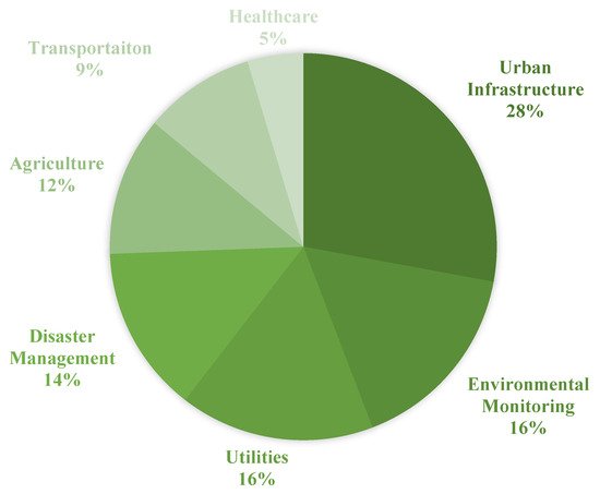
2. Urban Infrastructure
Utilizing GIS holds some benefits in the phases of developing a new infrastructure namely planning, designing, construction, and operation [5][13][14]. The capability of handling both spatial and non-spatial data makes GIS a great tool for performing efficient management. In addition, marking the ability to provide digital representations of the Earth’s surface, Reference [15] suggests developing digital urban infrastructure. With the great functionalities provided by IoT and GIS mentioned above, the integration of these two technologies would result in more effective systems. Reference [16] investigates other technologies like GIS to be integrated with IoT to be used in different aspects of urban infrastructure.
3. Transportation
The combination of GIS and Transportation called GIS-T [17][18] holds some benefits in facing the problems like transportation planning [19][20], design [21], maintenance [22], and decision-making [23][24]. In Reference [18], GIS-T is discussed in three stages namely the map view, the navigational view, and the behavioral view. The map view stage relates to inventory and description of transportation systems. The second stage, the navigational view, focuses on connectivity and planarity in addition to storing time-dependent attributes. Finally, dealing with transportation-related events as dynamic ones are proposed in the behavioral stage. In order to tackle the future challenges of transportation systems, the combination of WebGIS/cloud computing/big data is suggested in [17]. In addition, IoT by providing affordable sensors together with the proliferation of internet infrastructure can be helpful in GIS-T. Reference [25] proposes an IoT-based ITS constructed by three components namely the sensor system, monitoring system, and the display system.
4. Disaster Management
With the development of technologies, new strategies could be proposed to improve disaster management. Reference [26] explores the application of IoT and other technologies naming RFID, GPS, GIS, and Wireless Sensor Network (WSN) in disaster management approaches. In this research, studies are analyzed according to the technologies and tools they utilized and their studies supporting phase in disaster management.
According to Reference [26], RFID, a valuable technology, has been used in disaster management studies the most. In addition, GIS, being used nearly by 60%, can be considered almost as an inextricable part of disaster management where Reference [27] suggests exploiting GIS due to the advantages over conventional maps. It is also worth mentioning that the capability of GIS as a simulating tool is highlighted in [26] by analyzing studies utilizing GIS and WSN to predict flood damage [28][29].
5. Environmental Monitoring
IoT can be beneficial in implementing environmental managing systems such as real-time monitoring by means of storing the data, transmission, and processing remotely. Reference [30] presents a system that monitors water quality by measuring five parameters like the turbidity and temperature of the water using IoT. The monitoring system proposed in this study diminished the time and costs in assessing water quality in reservoirs. In addition to IoT, GIS can play a significant role in monitoring systems as well [31][32][33]. As mentioned in [32] the ability of GIS to handle geometric, thematic, and temporal geospatial data makes it suitable for environmental data management. Therefore, the integration of GIS and IoT studies would provide more advantages at the same time in environmental monitoring systems.
6. Agriculture
7. Utilities
For Waste Management, GIS plays a significant role mostly in optimizing the municipal waste collection system [52][53], vehicle routing, and scheduling the systems [54][55][56]. GIS helps decision-makers in analyzing and simulating different spatial scenarios by providing an advanced modeling framework [52][57]. The proliferation of sensors and the capabilities of IoT in real-time managing and monitoring holds some benefit in the waste collection too [58].
For Lighting, two problems are faced by most researchers. First, lighting data does not satisfy the proper spatial resolution. Besides, collecting data by measurement campaigns is costly [59][60]. A networked lighting system would be advantageous in local optimizations of illumination due to the presence of sensors [61]. Integrating such systems with IoT will result in remote management [60]. In addition, smart lighting is introduced as one of the most relevant uses of IoT in smart cities by The IoT European Research Cluster (IERC) [62]. The research performed by [59] indicates a need for a more effective lighting infrastructure in urban areas not only to bring luminance but also to provide safety for citizens. Therefore, they proposed a local illuminance GIS mapping. GIS is used to store automatically the ID of the sensors, light measurement data, the timestamp of the measurement, and the GPS position. Besides a tool for storing data, GIS is responsible for processing and displaying the information through the map of the quality of streetlights which can also be interpreted by quantitative indexes which area suffers from a low-security level. Therefore, GIS as a mapping tool and IoT by the cost-efficiency potential can be beneficial in lighting issues of cities. Traditional lighting systems suffer from a lack of efficiency in monitoring and are costly in energy and price too [63].
For Water Management, digital maps and special tools in GIS can enhance the efficiency of sewerage networks [64]. ArcCatalog and ArcGIS can be used as network design and analysis tools [65]. The network, designed in ArcCatalog, holds benefits in designing and implementing sewerage systems [66][67], analyzing and monitoring such systems [68][69], and simulating like that of urban sewerage flow volume [70][71].
8. Healthcare
References
- Mbuh, M.; Metzger, P.; Brandt, P.; Fika, K.; Slinkey, M. Application of real-time GIS analytics to support spatial intelligent decision-making in the era of big data for smart cities. EAI Endorsed Trans. Smart Cities 2020, 4, e3.
- Ye, J.; Chen, B.; Liu, Q.; Fang, Y. A precision agriculture management system based on Internet of Things and WebGIS. In Proceedings of the 2013 21st International Conference on Geoinformatics, Kaifeng, China, 20–22 June 2013; IEEE: New York, NY, USA, 2013.
- Fang, S.; Da Xu, L.; Zhu, Y.; Ahati, J.; Pei, H.; Yan, J.; Liu, Z. An integrated system for regional environmental monitoring and management based on internet of things. IEEE Trans. Ind. Inform. 2014, 10, 1596–1605.
- Lwin, K.K.; Sekimoto, Y.; Takeuchi, W.; Zettsu, K. City Geospatial Dashboard: IoT and Big Data Analytics for Geospatial Solutions Provider in Disaster Management. In Proceedings of the 2019 International Conference on Information and Communication Technologies for Disaster Management (ICT-DM), Paris, France, 18–20 December 2019; IEEE: New York, NY, USA, 2019.
- Saračević, M.; Plojović, Š.; Bušatlić, S. IoT Application for Smart Cities Data Storage and Processing Based on Triangulation Method. In Internet of Things (IoT); Springer: New York, NY, USA, 2020; pp. 317–334.
- Miloudi, L.; Rezeg, K. Leveraging the Power of Integrated Solutions of IoT and GIS. In Proceedings of the 2018 3rd International Conference on Pattern Analysis and Intelligent Systems (PAIS), Tebessa, Algeria, 24–25 October 2018; IEEE: New York, NY, USA, 2018.
- Arasteh, H.; Hosseinnezhad, V.; Loia, V.; Tommasetti, A.; Troisi, O.; Shafie-khah, M.; Siano, P. Iot-Based Smart Cities: A Survey. In Proceedings of the 2016 IEEE 16th International Conference on Environment and Electrical Engineering (EEEIC), Florence, Italy, 7–10 June 2016; pp. 1–6.
- Patti, E.; Acquaviva, A. IoT platform for Smart Cities: Requirements and implementation case studies. In Proceedings of the 2016 IEEE 2nd International Forum on Research and Technologies for Society and Industry Leveraging a Better Tomorrow (RTSI), Bologna, Italy, 7–9 September 2016; IEEE: New York, NY, USA, 2016.
- Cheng, Y.; Zhao, L. Application and research of GIS intelligent environmental protection Internet of things system construction technology. In Proceedings of the 2019 International Conference on Information Technology and Computer Application (ITCA), Guangzhou, China, 20–22 December 2019; IEEE: New York, NY, USA, 2019.
- Wang, L.-q.; Jia, J.-w. A Design of Environmental Quality Management Information System Based on IOT and GIS. Environ. Sci. Surv. 2012, 3, 1–2.
- Peng, S.; Su, G.; Chen, J.; Du, P. Design of an IoT-BIM-GIS based risk management system for hospital basic operation. In Proceedings of the 2017 IEEE Symposium on Service-Oriented System Engineering (SOSE), San Francisco, CA, USA, 6–9 April 2017; IEEE: New York, NY, USA, 2017.
- Al-Fuqaha, A.; Guizani, M.; Mohammadi, M.; Aledhari, M.; Ayyash, M. Internet of things: A survey on enabling technologies, protocols, and applications. IEEE Commun. Surv. Tutor. 2015, 17, 2347–2376.
- Palve, S.N. Application of gis in infrastructure project management. Int. J. Struct. Civ. Eng. Res. 2013, 2, 110–122.
- Shahrour, I. Use of GIS in smart city projects. GIM Int. Worldw. Mag. Geomat. 2018, 32, 21–23.
- Longley, P. GIS and the development of digital urban infrastructure. Environ. Plan. B Plan. Des. 1998, 25, 53–56.
- Medina, C.A.; Pérez, M.R.; Trujillo, L.C. IoT paradigm into the smart city vision: A survey. In Proceedings of the 2017 IEEE International Conference on Internet of Things (iThings) and IEEE Green Computing and Communications (GreenCom) and IEEE Cyber, Physical and Social Computing (CPSCom) and IEEE Smart Data (SmartData), Exeter, UK, 21–23 June 2017; IEEE: New York, NY, USA, 2017.
- Shaw, S.-L. GIS for Transportation. In International Encyclopedia of Geography: People, the Earth, Environment and Technology; John Wiley & Sons: Hoboken, NJ, USA, 2016; pp. 1–9.
- Goodchild, M.F. GIS and transportation: Status and challenges. GeoInformatica 2000, 4, 127–139.
- Miller, H.J.; Wu, Y.-H. GIS software for measuring space-time accessibility in transportation planning and analysis. GeoInformatica 2000, 4, 141–159.
- Liu, S.; Zhu, X. Accessibility analyst: An integrated GIS tool for accessibility analysis in urban transportation planning. Environ. Plan. B Plan. Des. 2004, 31, 105–124.
- Lemire, P.O.; Delcroix, B.; Audy, J.F.; Labelle, F.; Mangin, P.; Barnabé, S. GIS method to design and assess the transportation performance of a decentralized biorefinery supply system and comparison with a centralized system: Case study in southern Quebec, Canada. Biofuels Bioprod. Biorefin. 2019, 13, 552–567.
- Pantha, B.R.; Yatabe, R.; Bhandary, N.P. GIS-based highway maintenance prioritization model: An integrated approach for highway maintenance in Nepal mountains. J. Transp. Geogr. 2010, 18, 426–433.
- Giuffrida, N.; Le Pira, M.; Inturri, G.; Ignaccolo, M. Mapping with stakeholders: An overview of public participatory GIS and VGI in transport decision-making. ISPRS Int. J. Geo-Inf. 2019, 8, 198.
- Arampatzis, G.; Kiranoudis, C.T.; Scaloubacas, P.; Assimacopoulos, D. A GIS-based decision support system for planning urban transportation policies. Eur. J. Oper. Res. 2004, 152, 465–475.
- Bojan, T.M.; Kumar, U.R.; Bojan, V.M. An internet of things based intelligent transportation system. In Proceedings of the 2014 IEEE International Conference on Vehicular Electronics and Safety, Hyderabad, India, 16–17 December 2014; IEEE: New York, NY, USA, 2014.
- Zafar, U.; Shah, M.A.; Wahid, A.; Akhunzada, A.; Arif, S. Exploring IoT applications for disaster management: Identifying key factors and proposing future directions. In Recent Trends and Advances in Wireless and IoT-Enabled Networks; Springer: New York, NY, USA, 2019; pp. 291–309.
- Tran, P.; Shaw, R.; Chantry, G.; Norton, J. GIS and local knowledge in disaster management: A case study of flood risk mapping in Viet Nam. Disasters 2009, 33, 152–169.
- Khan, F.; ur Rehman, A.; Usman, M.; Tan, Z.; Puthal, D. Performance of cognitive radio sensor networks using hybrid automatic repeat ReQuest: Stop-and-wait. Mob. Netw. Appl. 2018, 23, 479–488.
- Liu, J.; Wen, J.; Yang, K.; Shang, Z.; Zhang, H. GIS-based analysis of flood disaster risk in LECZ of China and population exposure. In Proceedings of the 2011 19th International Conference on Geoinformatics, Shanghai, China, 24–26 June 2011; IEEE: New York, NY, USA, 2011.
- Nikhil, R.; Rajender, R.; Dushyantha, G.; Jagadevi, N. Smart water quality monitoring system using IoT environment. Int. J. Innov. Eng. Technol 2018, 10, 29–31.
- Li, Z.-W.; Zeng, G.-M.; Zhang, H.; Yang, B.; Jiao, S. The integrated eco-environment assessment of the red soil hilly region based on GIS—A case study in Changsha City, China. Ecol. Model. 2007, 202, 540–546.
- Karimipour, F.; Delavar, M.R.; Kinaie, M. Water quality management using GIS data mining. J. Environ. Inform. 2005, 5, 61–71.
- Assaf, H.; Saadeh, M. Assessing water quality management options in the Upper Litani Basin, Lebanon, using an integrated GIS-based decision support system. Environ. Model. Softw. 2008, 23, 1327–1337.
- Wilson, J. Local, national, and global applications of GIS in agriculture. In Geographical Information Systems: Management Issues and Applications; Wiley: Hoboken, NJ, USA, 1999; pp. 981–998.
- Ahmed, A.; Shibasaki, R. Climate Change and Agricultural Food Production of Bangladesh: An IMPACT assessment Using GIS-Based Biophysical Crop Simulation Model. Available online: https://www.geospatialworld.net/article/climate-change-and-agricultural-food-production-of-bangladesh-an-impact-assessment-using-gis-based-biophysical-crop-simulation-model/ (accessed on 11 December 2020).
- Peters, C.J.; Bills, N.L.; Lembo, A.J.; Wilkins, J.L.; Fick, G.W. Mapping potential foodsheds in New York State: A spatial model for evaluating the capacity to localize food production. Renew. Agric. Food Syst. 2009, 24, 72–84.
- Eckert, J.; Shetty, S. Food systems, planning and quantifying access: Using GIS to plan for food retail. Appl. Geogr. 2011, 31, 1216–1223.
- Zhao, Q.; Jin, G.; Zhou, W.; Wang, C.; Dai, J. Information collection system for diseases and pests in cotton fieldbased on mobile GIS. Trans. Chin. Soc. Agric. Eng. 2015, 31, 183–190.
- Zhao, P.; Liu, G.; Li, M.; Li, D. Management information system for apple diseases and insect pests based on GIS. Trans. Chin. Soc. Agric. Eng. 2006, 22, 150–154.
- Bolo, B.; Mpoeleng, D. Mapping of crop birds pest using GPS and GIS. J. Agric. Inform. 2019, 10, 12–20.
- Fenu, G.; Malloci, F.M. An Application of Machine Learning Technique in Forecasting Crop Disease. In Proceedings of the 2019 3rd International Conference on Big Data Research, Melbourn, Australia, 22–24 August 2019; pp. 76–82.
- Koua, J.-J.T.; Anoh, A.K.; Soro, D.T.; Kouame, J.K.; Jourda, R.J.P. Evaluation of Agricultural Practices Scenarios for Reducing Erosion in Buyo Lake Catchment (Sassandra; Côte d’Ivoire) by Use of GIS. J. Geosci. Environ. Prot. 2019, 7, 154–171.
- Tsegaye, K.; Addis, H.K.; Hassen, E.E. Soil Erosion Impact Assessment using USLE/GIS Approaches to Identify High Erosion Risk Areas in the Lowland Agricultural Watershed of Blue Nile Basin, Ethiopia. Int. Ann. Sci. 2020, 8, 120–129.
- Kouli, M.; Soupios, P.; Vallianatos, F. Soil erosion prediction using the revised universal soil loss equation (RUSLE) in a GIS framework, Chania, Northwestern Crete, Greece. Environ. Geol. 2009, 57, 483–497.
- Iverson, L.; Prasad, A. Estimating regional plant biodiversity with GIS modelling. Divers. Distrib. 1998, 4, 49–61.
- Geyer, R.; Stoms, D.M.; Lindner, J.P.; Davis, F.W.; Wittstock, B. Coupling GIS and LCA for biodiversity assessments of land use: Part 1: Inventory modeling. Int. J. Life Cycle Assess. 2010, 15, 454–467.
- Parker, L.; Bourgoin, C.; Martinez-Valle, A.; Läderach, P. Vulnerability of the agricultural sector to climate change: The development of a pan-tropical Climate Risk Vulnerability Assessment to inform sub-national decision making. PLoS ONE 2019, 14, e0213641.
- Dalsted, K. Introduction: Remote sensing and GIS techniques for the detection, surveillance, and management of invasive species. In GIS Applications in Agriculture, Volume Three; CRC Press: Boca Raton, FL, USA, 2011; pp. 16–23.
- Sánchez, L.; Elicegui, I.; Cuesta, J.; Muñoz, L.; Lanza, J. Integration of utilities infrastructures in a future internet enabled smart city framework. Sensors 2013, 13, 14438–14465.
- Simmhan, Y.; Ravindra, P.; Chaturvedi, S.; Hegde, M.; Ballamajalu, R. Towards a data-driven IoT software architecture for smart city utilities. Softw. Pract. Exp. 2018, 48, 1390–1416.
- Wang, M.; Deng, Y.; Won, J.; Cheng, J.C. An integrated underground utility management and decision support based on BIM and GIS. Autom. Constr. 2019, 107, 102931.
- Chalkias, C.; Lasaridi, K. A GIS based model for the optimisation of municipal solid waste collection: The case study of Nikea, Athens, Greece. Technology 2009, 1, 11–15.
- Kallel, A.; Serbaji, M.M.; Zairi, M. Using GIS-Based tools for the optimization of solid waste collection and transport: Case study of Sfax City, Tunisia. J. Eng. 2016, 2016, 4596849.
- Chang, N.-B.; Lu, H.; Wei, Y. GIS technology for vehicle routing and scheduling in solid waste collection systems. J. Environ. Eng. 1997, 123, 901–910.
- Malakahmad, A.; Bakri, P.M.; Mokhtar, M.R.M.; Khalil, N. Solid waste collection routes optimization via GIS techniques in Ipoh city, Malaysia. Procedia Eng. 2014, 77, 20–27.
- Hemidat, S.; Oelgemöller, D.; Nassour, A.; Nelles, M. Evaluation of Key Indicators of Waste Collection Using GIS Techniques as a Planning and Control Tool for Route Optimization. Waste Biomass Valorization 2017, 8, 1533–1554.
- Chalkias, C.; Lasaridi, K. Optimizing municipal solid waste collection using GIS. In Proceedings of the 5th International Conference on Energy, Environment, Ecosystems and Sustainable Development/2nd International Conference on Landscape Architecture, Athens, Greece, 28–30 September 2009; pp. 45–50.
- Anagnostopoulos, T.; Zaslavsy, A.; Medvedev, A.; Khoruzhnicov, S. Top--k query based dynamic scheduling for IoT-enabled smart city waste collection. In Proceedings of the 2015 16th IEEE International Conference on Mobile Data Management, Pittsburgh, PA, USA, 15–18 June 2015; IEEE: New York, NY, USA, 2015; pp. 50–55.
- Tagliabue, L.C.; Re Cecconi, F.; Moretti, N.; Rinaldi, S.; Bellagente, P.; Ciribini, A.L.C. Security Assessment of Urban Areas through a GIS-Based Analysis of Lighting Data Generated by IoT Sensors. Appl. Sci. 2020, 10, 2174.
- Pandharipande, A.; Zhao, M.; Frimout, E.; Thijssen, P. IoT lighting: Towards a connected building eco-system. In Proceedings of the 2018 IEEE 4th World Forum on Internet of Things (WF-IoT), Singapore, 5–8 Febbruary 2018; IEEE: New York, NY, USA, 2018; pp. 664–669.
- Caicedo, D.; Pandharipande, A. Distributed illumination control with local sensing and actuation in networked lighting systems. IEEE Sens. J. 2012, 13, 1092–1104.
- Bodei, C.; Degano, P.; Ferrari, G.-L.; Galletta, L. Where do your IoT ingredients come from? In Coordination Models and Languages, Proceedings of the International Conference on Coordination Languages and Models, Heraklion, Greece, 6–9 June 2016; Springer: Cham, Switzerland, 2016; pp. 35–50.
- Yu-de ZHANG Chang-hao, D.; Meng-meng, D.B.-y.L.; Qing-peng, Q.X.-h.D. Design of GIS-Based Digital Lighting System for City Road. J. South China Univ. Technol. (Nat. Sci.) 2016, 44, 51.
- Kruszynski, W.; Dawidowicz, J.; Andraka, D.; Tomaszewska, J. Application and digital implementation GIS data to computer modeling of the sanitary sewage network in Podlaskie voivodship. Ekon. Śr. 2018, 65, 9.
- Adam, K.J. Management of Sewerage Network by Using GIS. Master’s Thesis, Sudan University of Science and Technology, Khartoum, Sudan, 2015.
- Fellers, J. Implementing a Geographic Information System for a Rural Water and Sewer Company: A Case Study of the Newberry County Water and Sewer Authority: A Thesis Presented to the Department of Humanities and Social Sciences in Candidacy for the Degree of Master of Science. Ph.D. Thesis, Northwest Missouri State University, Maryville, MO, USA, 2013.
- Patil, J.; Kulkarni, S. Design and mapping of underground sewerage network in GIS, a case study of Islampur Town. Int. J. Sci. Res. 2012, 3, 2319–7064.
- Abdelbaki, C.; Rouissat, B.; Charef, I.; Abdelkader, A.H. Management of a Sewerage Network by Coupling GIS and Hydraulic Modeling: A Case Study of the Network of the New University in Tlemcen, Algeria. LARHYSS J. 2016, 28, 167–179.
- Mugambi, B.K. Application of GIS and Remote Sensing in Enhancing Sewer Reticulation Networks, Case Study of Nyeri Municipality. Available online: http://repository.dkut.ac.ke:8080/xmlui/handle/123456789/1179 (accessed on 11 December 2020).
- Yoo, J. GIS-based simulation of urban sewerage flow volume. Urban Water J. 2005, 2, 1–12.
- Mohsin, A.N. Using 3D Analysis of GIS and Remote Sensing for Modeling Erbil Water Flow and Sewerage Network. Eng. Technol. J. 2010, 28, 4910–4925.
- Dulin, M.F.; Ludden, T.M.; Tapp, H.; Blackwell, J.; de Hernandez, B.U.; Smith, H.A.; Furuseth, O.J. Using Geographic Information Systems (GIS) to understand a community’s primary care needs. J. Am. Board Fam. Med. 2010, 23, 13–21.
- Dogru, A.O.; David, R.M.; Ulugtekin, N.; Goksel, C.; Seker, D.Z.; Sözen, S. GIS based spatial pattern analysis: Children with Hepatitis A in Turkey. Environ. Res. 2017, 156, 349–357.
- Bui, T.Q.; Pham, H.M. Web-based GIS for spatial pattern detection: Application to malaria incidence in Vietnam. SpringerPlus 2016, 5, 1014.
- Mollalo, A.; Mao, L.; Rashidi, P.; Glass, G.E. A GIS-based artificial neural network model for spatial distribution of tuberculosis across the continental United States. Int. J. Environ. Res. Public Health 2019, 16, 157.
- Rai, P.K.; Nathawat, M.S. GIS in Healthcare Planning: A Case Study of Varanasi, India. Forum Geografic 2013, 12, 153–163.
- Elmes, G.A. 13 GIS in Public Healthcare Planning: The United States Perspective. In GIS in Public Health Practice; CRC Press: Boca Raton, FL, USA, 2016; p. 205.
- Kim, Y.; Byon, Y.-J.; Yeo, H. Enhancing healthcare accessibility measurements using GIS: A case study in Seoul, Korea. PLoS ONE 2018, 13, e0193013.
- Dejen, A.; Soni, S.; Semaw, F. Spatial accessibility analysis of healthcare service centers in Gamo Gofa Zone, Ethiopia through Geospatial technique. Remote Sens. Appl. Soc. Environ. 2019, 13, 466–473.
- Yeole, A.S.; Kalbande, D.R. Use of Internet of Things (IoT) in healthcare: A survey. In Proceedings of the ACM Symposium on Women in Research, Indore, India, 21–22 March 2016; pp. 71–76.
- Babu, B.S.; Srikanth, K.; Ramanjaneyulu, T.; Narayana, I.L. IoT for healthcare. Int. J. Sci. Res. 2016, 5, 322–326.


